ATL GUSTAV: Tropical Depression - Discussion
Moderator: S2k Moderators
-
Just Joshing You

- Category 2

- Posts: 512
- Joined: Sat Nov 03, 2007 10:29 am
- Location: Nova Scotia


-
SouthFLTropics

- Category 5

- Posts: 4258
- Age: 50
- Joined: Thu Aug 14, 2003 8:04 am
- Location: Port St. Lucie, Florida
Re: Cat. 2 Hurricane Gustav in NW Caribbean Sea
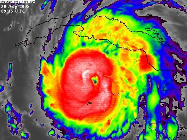
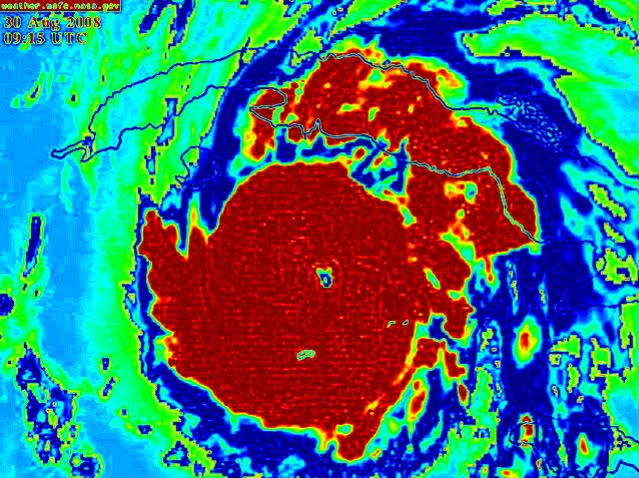
One thing is for sure...If Gustav didn't have the Gulf Coast's full attention last night, he will this morning...Especially when everyone gets up and see's him flexing his muscle...
SFT
SFT
0 likes
-
Derek Ortt
-
USTropics
- Professional-Met

- Posts: 2738
- Joined: Sun Aug 12, 2007 3:45 am
- Location: Florida State University
Re: Cat. 2 Hurricane Gustav in NW Caribbean Sea
Just to add a little bit more on hot towers:
Basically a hot tower is when a very tall, dense cumulonimbus cloud builds from the lowest layer of the troposphere and stretches upwards to the stratosphere. They can reach upwards of 11 miles in height. When such a vast amount of latent heat is produced due to the rising of moist air, which results in a cooling mechanism of the water vapor into liquid water, we can see hot towers form. When a hot tower forms, it generally acts like the pistons found in an engine, releasing energy in to the center of the storm resulting in lowering of surface pressure and consequently increasing wind speed.
Cooling cloud tops is an indication of convection building upwards. It does not always constitute a hot tower forming.
0 likes

Re: Cat. 2 Hurricane Gustav in NW Caribbean Sea
Pressure continued to drop even after the wind shift. What do you make of that Derek from an RI'ing storm?
EDIT: NM they did a loop. I'm an idiot.
EDIT: NM they did a loop. I'm an idiot.
Last edited by RL3AO on Sat Aug 30, 2008 4:35 am, edited 1 time in total.
0 likes
-
Just Joshing You
- Category 2
- Posts: 512
- Joined: Sat Nov 03, 2007 10:29 am
- Location: Nova Scotia
Re: Cat. 2 Hurricane Gustav in NW Caribbean Sea
SouthFLTropics wrote:One thing is for sure...If Gustav didn't have the Gulf Coast's full attention last night, he will this morning...Especially when everyone gets up and see's him flexing his muscle...
SFT
METEOROLOGICAL MUSCLE
0 likes
-
Hurricanewatcher2007

- Category 2
- Posts: 578
- Joined: Sat Jul 05, 2008 8:10 pm
-
Just Joshing You
- Category 2
- Posts: 512
- Joined: Sat Nov 03, 2007 10:29 am
- Location: Nova Scotia
-
Hurricanewatcher2007
- Category 2
- Posts: 578
- Joined: Sat Jul 05, 2008 8:10 pm
Re: Cat. 2 Hurricane Gustav in NW Caribbean Sea
the last VDM was at 7:41 and had a pressure of 965mb
0 likes
-
Just Joshing You
- Category 2
- Posts: 512
- Joined: Sat Nov 03, 2007 10:29 am
- Location: Nova Scotia
Re:
bob rulz wrote:Another special advisory/update coming soon? I think it's officially in RI now.
It already has been noted by NHC. First line of Disco:
GUSTAV HAS BEEN RAPIDLY INTENSIFYING DURING THE OVERNIGHT HOURS.
0 likes
-
Hurricanewatcher2007
- Category 2
- Posts: 578
- Joined: Sat Jul 05, 2008 8:10 pm
Who is online
Users browsing this forum: No registered users and 21 guests