ATL GUSTAV: Tropical Depression - Discussion
Moderator: S2k Moderators
-
USTropics
- Professional-Met

- Posts: 2738
- Joined: Sun Aug 12, 2007 3:45 am
- Location: Florida State University
Re: Cat. 4 Hurricane Gustav in NW Caribbean Sea
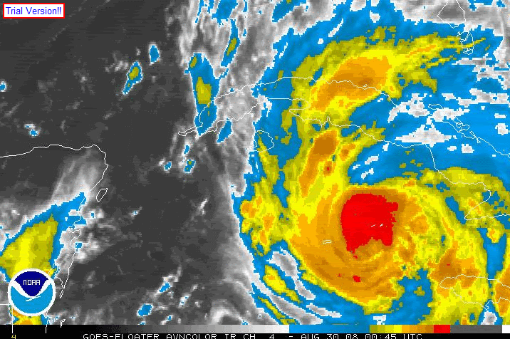
I downloaded the last 25 frames and have then converged them in to 1 .gif image:
0 likes
-
Brent
- S2K Supporter

- Posts: 38735
- Age: 37
- Joined: Sun May 16, 2004 10:30 pm
- Location: Tulsa Oklahoma
- Contact:
Re: Cat. 4 Hurricane Gustav in NW Caribbean Sea
njweather wrote:Holy poop....
Does anyone know what kind of cities in Cuba are going to be slammed, pop. / poverty-wise?
My prayers for those in its path...
Looks like it's going to pass just west of Havana which would put them near if not in the worst weather.
and it should be noted, it's the most narrow part.
Last edited by Brent on Sat Aug 30, 2008 12:28 pm, edited 1 time in total.
0 likes
-
6SpeedTA95
- Category 5

- Posts: 1206
- Joined: Wed Oct 19, 2005 3:25 pm
- Location: Oklahoma
- Contact:
Re:
Ummm poop? what else is there to say, I hope to God in heaven that is wrong.Scorpion wrote:HWRF 904 mb at landfall
0 likes
Re: Re:
gboudx wrote:cpdaman wrote:gboudx wrote:What track are you guys looking at? I'm plotting on the NHC's website and it appears pretty much spot on, albeit some wobbles, but overall motion pretty much on track. Certainly not "way east".
you have to understand one thing
every 6 hours they update the forecast points to account for where the storm now is
at 11 they moved them east, that is why they look on target right now ( and i am only talking about the first couple forecast points, not the final landfall yet)
So we're not talking about what we have current? Gotcha. How about we plot against the track the NHC had when it came off of Haiti. I bet it's way off too.
I feel like I'm getting sucked into the wobble-war/-removed- bullcrap. Nevermind.
mods i'm just trying to clear any confusion other on the board may have , that's why i'm responding again
you must understand that when you look and see the forecast point on the map that they are updated every 6 hours, the storm will ALWAYS "appear" close to the track, no matter how far off it is. because every 6 hours they are updated. Thus so long as the storm is not moving 50 mph it will only have 6 hours to deviate from track until the new update poops to match where it goes. in reality it has shifted east in the last 12 hours, NOT a huge distance, but signifcant. the shift i'm talking about is in the points near the center and up to the SE gulf, not final landfall yet
Last edited by cpdaman on Sat Aug 30, 2008 12:32 pm, edited 2 times in total.
0 likes
-
HURAKAN

- Professional-Met
- Posts: 46084
- Age: 39
- Joined: Thu May 20, 2004 4:34 pm
- Location: Key West, FL
- Contact:
Re: Cat. 4 Hurricane Gustav in NW Caribbean Sea
njweather wrote:Holy poop....
Does anyone know what kind of cities in Cuba are going to be slammed, pop. / poverty-wise?
My prayers for those in its path...
The entire area is very poor and most houses are poorly constructed. Still, I believe the Cuban government evacuated those at risk. In a communist country it's very easy to evacuate a population because when the government says "move," you better move.
0 likes


-
tolakram
- Admin

- Posts: 20183
- Age: 62
- Joined: Sun Aug 27, 2006 8:23 pm
- Location: Florence, KY (name is Mark)
Re: Cat. 4 Hurricane Gustav in NW Caribbean Sea
For those talking wobble I offer something to think about.
1. Wobbles should be either side of the forecast track but so far every poinnt has been missed to the north or east and been readjusted.
2. The forecast models initialize at the storm location that's fed into them. If the storm continues to be more east then the models will initialize more east and MAY or MAY NOT start trending to the east.
3. If Gustav has a large eye when making landfall locations well east of the forecast point may experience the brunt of this storm. If Gustav continues to 'wobble' east this could be significant.
That's all, not a forecast but not something to be ignored either. It's very important not to focus on the line, understand the trends, and not be surprised as reality dictates changes in the forecast.
To see past NHC forecasts you can look at the snake:
http://www.nhc.noaa.gov/archive/2008/gr ... p_5W.shtml
0 likes
-
ConvergenceZone
.gif)
- Category 5
- Posts: 5241
- Joined: Fri Jul 29, 2005 1:40 am
- Location: Northern California
Re: Re:
Stormcenter wrote:gboudx wrote:From WV and IR, looks like most intense convection is on the west side like this morning before it wrapped up. Why is the convection maintaining on the west but not the east?
Sorry if this has been discussed before.
A good sign!!!
Hey StormCenter, I know you are trying to be positive and think of every positive scenerio you can for this storm, and I don't blame you, but ya got to face it, this is NOT looking good. Even the latest discussions don't seem as bullish on the weakening as they were yesterday.The last discussion said that they don't expect it to weaken much in the gulf.....Yeasterday all we heard about with the discussions was the trough and shear, but not to much today. They are still expecting this to strike the gulf coast as a MAJOR hurricane... The tough part is the eyewall replacement cycles, which have been known to significantly weaken a storm, but there is no way to even know when those are going to happen. It can happen in the mid gulf and be wound up again to strike the coast a major.....One thing for sure, Gustav has its act together, and I don't really see anything standing in it's way......It's going to be devastating no matter where it hits, and it's looking like that more and more by the hour.
0 likes
Re: Cat. 4 Hurricane Gustav in NW Caribbean Sea
Are we watching a Cat 5 landfall for Cuba in the making?
0 likes

-
HURAKAN
- Professional-Met
- Posts: 46084
- Age: 39
- Joined: Thu May 20, 2004 4:34 pm
- Location: Key West, FL
- Contact:
Re: Cat. 4 Hurricane Gustav in NW Caribbean Sea
jinftl wrote:Are we watching a Cat 5 landfall for Cuba in the making?
It's possible but I hope it doesn't become a reality.
0 likes
-
apocalypt-flyer
- Category 1

- Posts: 468
- Joined: Sat Aug 27, 2005 11:51 am
Re: Cat. 4 Hurricane Gustav in NW Caribbean Sea
Whilst it might not hit Juventud full one the Isle is certainly going to get the Western eyewall without any compromises.
I suppose there results and pictures will be devastating tomorrow. One can only say good luck to everyone in Gustav's track at the moment.
I suppose there results and pictures will be devastating tomorrow. One can only say good luck to everyone in Gustav's track at the moment.
0 likes
Re: Cat. 4 Hurricane Gustav in NW Caribbean Sea
Something to consider...if Gustav enters the Gulf as a Cat 4 or 5.....it will be developing a Cat 4 or 5 surge....even if he weakens some as he approaches the Gulf Coast to say a Cat 3, we all know that the surge doesn't always diminish as fast.
0 likes
-
gboudx

- S2K Supporter
- Posts: 4090
- Joined: Thu Sep 04, 2003 1:39 pm
- Location: Rockwall, Tx but from Harvey, La
Re: Re:
cpdaman wrote:
mods i'm just trying to clear any confusion other on the board may have , that's why i'm responding again
you must understand that when you look and see the forecast point on the map that they are updated every 6 hours, the storm will ALWAYS "appear" close to the track, no matter how far off it is. because every 6 hours they are updated. Thus so long as the storm is not moving 50 mph it will only have 6 hours to deviate from track until the new update poops to match where it goes. in reality it has shifted east in the last 12 hours, NOT a huge distance, but signifcant. the shift i'm talking about is in the points near the center and up to the SE gulf, not final landfall yet
Okay, then yes I am confused. How do you guys decide which past track you're gonna use to determine current motion relative to previous track?
0 likes
-
cycloneye

- Admin
- Posts: 149342
- Age: 69
- Joined: Thu Oct 10, 2002 10:54 am
- Location: San Juan, Puerto Rico
Re: Cat. 4 Hurricane Gustav in NW Caribbean Sea
HURAKAN,there are no mountains in the Isle of Juventud right?
0 likes
-
CrazyC83
- Professional-Met
- Posts: 34315
- Joined: Tue Mar 07, 2006 11:57 pm
- Location: Deep South, for the first time!
Re: Cat. 4 Hurricane Gustav in NW Caribbean Sea
jinftl wrote:Are we watching a Cat 5 landfall for Cuba in the making?
I think so.
0 likes


Who is online
Users browsing this forum: No registered users and 31 guests