ATL GUSTAV: Tropical Depression - Discussion
Moderator: S2k Moderators
-
Weather Watcher

- Tropical Storm

- Posts: 171
- Joined: Tue Aug 30, 2005 7:03 pm
- Location: Wisconsin
- Contact:
according to the latest loop it looks like the eye disappeared but I know when it gets to ocean look out Yipes

Last edited by Weather Watcher on Sat Aug 30, 2008 7:36 pm, edited 1 time in total.
0 likes

Re: Cat. 4 Hurricane Gustav over Western Cuba
GFDL and HWRF are NOT on top of NOLA exactly...but that is a shift in those models...earlier GFDL was on the west side of Vermillion bay...now you could argue the eye/eyewall will land on Lafourche/maybe eastern Terrebone...same thing with HWRF. I cant tell exactly but you could argue they are even a hair east of the NHC line at this point. And yes if those pan out they are very bad surge wise into New Orleans, I would say worse than the 12 z or 6 z runs by a long shot...
0 likes
-
tolakram
- Admin

- Posts: 20183
- Age: 62
- Joined: Sun Aug 27, 2006 8:23 pm
- Location: Florence, KY (name is Mark)
Re: Cat. 4 Hurricane Gustav over Western Cuba
I think that small mountain range where Gustav crossed has done a number on structure.
http://hadar.cira.colostate.edu/ramsdis ... at2_0.html

http://hadar.cira.colostate.edu/ramsdis ... at2_0.html
0 likes
-
Hurricanewatcher2007

- Category 2

- Posts: 578
- Joined: Sat Jul 05, 2008 8:10 pm
Re: Cat. 4 Hurricane Gustav over Western Cuba
carversteve wrote: What is 146 kts in mph..i love weather, but am challenged beyond that!
146kts is 167.9mph you multiply the speed in kts by 1.15 to get mph
0 likes

Re: Cat. 4 Hurricane Gustav over Western Cuba
senorpepr wrote:peteywheatstraw wrote:The cone of uncertainty is not infallible. 48 hrs before Katrina made landfall it wasn't even in SE La.
I'm throwing a BS flag here. If you check out advisory number ONE... (about six days out), New Orleans was in the cone.
Senor, as someone who lived in Slidell prior to Katrina and a member of this forum, it was projected to go into the panhandle of Florida... It seems to me that it took a major shift in the track because we had been watching it until Thursday... it was only on Friday morning before it hit that it came into the cone of concern... We didn't realize it until Friday night and left the next day... it hit the following Monday morning... that means it was 72 hrs. out before the cone of concern ever included N.O.
0 likes
-
superfly
Re: Cat. 4 Hurricane Gustav over Western Cuba
tolakram wrote:I think that small mountain range where Gustav crossed has done a number on structure.
http://hadar.cira.colostate.edu/ramsdis ... at2_0.html
The structure looks fine, inner core looks intact. The eye is clouded over, but besides that, I don't think Cuba did much to Gustav.
0 likes

-
tolakram
- Admin
- Posts: 20183
- Age: 62
- Joined: Sun Aug 27, 2006 8:23 pm
- Location: Florence, KY (name is Mark)
Re: Cat. 4 Hurricane Gustav over Western Cuba
superfly wrote:tolakram wrote:I think that small mountain range where Gustav crossed has done a number on structure.
http://hadar.cira.colostate.edu/ramsdis ... at2_0.html
The structure looks fine, inner core looks intact. The eye is clouded over, but besides that, I don't think Cuba did much to Gustav.
Did you step through the loop to see what I was talking about?
0 likes

Re: Cat. 4 Hurricane Gustav over Western Cuba
tolakram wrote:I think that small mountain range where Gustav crossed has done a number on structure.
http://hadar.cira.colostate.edu/ramsdis ... at2_0.html
Check the radar - the inner core and eyewall are still intact. That's all that's needed for a "re-boom" over the Gulf.
Last edited by tallywx on Sat Aug 30, 2008 7:42 pm, edited 1 time in total.
0 likes
-
carversteve

- Tropical Storm
- Posts: 161
- Joined: Sat Aug 18, 2007 7:40 am
Re: Cat. 4 Hurricane Gustav over Western Cuba
Hurricanewatcher2007 wrote:carversteve wrote: What is 146 kts in mph..i love weather, but am challenged beyond that!
146kts is 167.9mph you multiply the speed in kts by 1.15 to get mph
WOW!! thats a lot of wind..

0 likes

Re: Cat. 4 Hurricane Gustav over Western Cuba
tolakram wrote:I think that small mountain range where Gustav crossed has done a number on structure.
http://hadar.cira.colostate.edu/ramsdis ... at2_0.html
looks like it hardly took the wind out of its sail to me, the eye is already halfway over water, will take no time at all to get back to what it was...and possibly stronger
0 likes
-
pablolopez26
- Tropical Storm
- Posts: 137
- Joined: Wed Aug 27, 2008 5:10 pm
Re: Cat. 4 Hurricane Gustav over Western Cuba
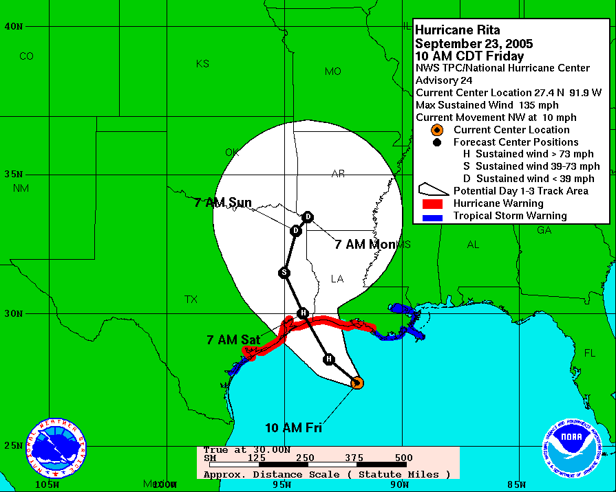
This is a Archived track of Hurricane Rita in 2005. As you can see the the lines mean nothing and kept changing. Even though this monster is slated to hit wester La, any number of variables can affect the steering of Gustav.
Just be careful all, and keep an eye on it.
http://www.nhc.noaa.gov/archive/2005/graphics/AT18/24.AL1805W.GIF
Just be careful all, and keep an eye on it.
http://www.nhc.noaa.gov/archive/2005/graphics/AT18/24.AL1805W.GIF
0 likes
-
tolakram
- Admin
- Posts: 20183
- Age: 62
- Joined: Sun Aug 27, 2006 8:23 pm
- Location: Florence, KY (name is Mark)
Re: Cat. 4 Hurricane Gustav over Western Cuba
Check the radar - the inner core and eyewall are still intact. That's all that's needed for a "re-boom" over the Gulf
Who said anything about it not re-intensifying? *sigh*, it's prime time, I forgot the demographics change, I'll wait to post interesting observations till later.
0 likes
-
soonertwister
- Category 5

- Posts: 1091
- Joined: Mon Jun 16, 2003 2:52 pm
Re:
tallywx wrote:Isn't the distance from Havana, Cuba to the center about the distance that New Orleans would be from the center if it follows the NHC track? If that's the case...well, all Havana is getting is 55 mph gusts. New Orleans can survive that.
The issue with NOLA isn't the winds, it never was. STORM SURGE is the deadly danger.
0 likes
-
carversteve
- Tropical Storm
- Posts: 161
- Joined: Sat Aug 18, 2007 7:40 am
Re: Cat. 4 Hurricane Gustav over Western Cuba
Just a question..is there anything that will make him lose any strength..besides that they usually weaken before landfall..Any troughs or shear or anything,because i'm not hearing any talk about any weakness at all.
0 likes
-
JtSmarts

- S2K Supporter

- Posts: 1442
- Age: 40
- Joined: Thu Jul 10, 2003 1:29 pm
- Location: Columbia, South Carolina
Re: Cat. 4 Hurricane Gustav over Western Cuba
carversteve wrote:Just a question..is there anything that will make him lose any strength..besides that they usually weaken before landfall..Any troughs or shear or anything,because i'm not hearing any talk about any weakness at all.
The heat potential will be less closer to landfall, but the NHC still expects at the least a major hurricane.
0 likes
-
ConvergenceZone
.gif)
- Category 5
- Posts: 5241
- Joined: Fri Jul 29, 2005 1:40 am
- Location: Northern California
Re: Cat. 4 Hurricane Gustav over Western Cuba
Just like our local meterologist just said, it's possible that this has weakend to a cat 3 storm, but that doesn't matter as it's expected to once again re-intensify and could reach cat 5 status(although not for sure).......
0 likes
-
Hurricanewatcher2007
- Category 2
- Posts: 578
- Joined: Sat Jul 05, 2008 8:10 pm
Re: Cat. 4 Hurricane Gustav over Western Cuba
carversteve wrote:Just a question..is there anything that will make him lose any strength..besides that they usually weaken before landfall..Any troughs or shear or anything,because i'm not hearing any talk about any weakness at all.
In the past advisories the NHC was talking about maybe some increase shear in the Northern GoM but today they don't seem to be saying to much about that so I am not sure whats up with that. But there are cooler waters so it shouldn't be able to maintain cat 5 status once in the Northern GoM if it should strengthen that much.
0 likes


Who is online
Users browsing this forum: No registered users and 15 guests