ATL: IKE Discussion

Moderator: S2k Moderators

Message
Author
tolakram
Admin
Admin
Posts: 20012
Age: 62
Joined: Sun Aug 27, 2006 8:23 pm
Location: Florence, KY (name is Mark)

Re: ATL IKE: Category 2 - Discussion

#9141 Postby tolakram » Thu Sep 11, 2008 12:12 pm

Loop:
http://weather.msfc.nasa.gov/cgi-bin/ge ... olor=white

Build your own

Code: Select all

http://weather.msfc.nasa.gov/cgi-bin/get-goes?satellite=GOES-E%20CONUS&lat=25&lon=-90&map=latlon&zoom=1&info=ir&quality=90&type=Animation&numframes=10&width=1200&height=800&palette=spect.pal&mapcolor=white
0 likes   

Frank P
S2K Supporter
S2K Supporter
Posts: 2776
Joined: Fri Aug 29, 2003 10:52 am
Location: Biloxi Beach, Ms
Contact:

Re:

#9142 Postby Frank P » Thu Sep 11, 2008 12:13 pm

Steve wrote:Agreed lys. Absent a VDM, and I'm so swamped at work between trying to unbury myself from last week's hiatus and watching Ike like a hawk that I don't even have time to fool with recon. I'm sure they'll mention it if they fly in there. On the WV loop Ed posted, you can see some deep convection riding east and north of there. If it wraps, I think we could say with certainty that it is the center. If not, well it might just be a transient feature within the confines of a larger circulation. Super interesting day of Ike watching. I think we're all learning a few things.

Steve


Not sure but I don't think its an eye... using this loop you see another very similar feature off to the east... also looks to be gobbled up at the end of this loop.. purely speculation on my part.

http://adds.aviationweather.gov/satelli ... g&itype=wv
0 likes   

jinftl
Category 5
Category 5
Posts: 4312
Joined: Tue Aug 31, 2004 4:47 pm
Location: fort lauderdale, fl

Re: Re:

#9143 Postby jinftl » Thu Sep 11, 2008 12:14 pm

The difference between being in the hurricane force sustained windfield and a storm-generated tornado...which generally are lower intensity than say a tornado alley tornado...may be immaterial in terms of damage.

Tornados a risk even further away from center....usually right frony quadrant.

THead wrote:
PTrackerLA wrote:Either way you cut it, a cat 2 of Ike's size will cause more damage than a small cat 3, bottom line. No one make the mistake of taking this lightly.


Yeah, I was also wondering how Ike's current configuration/size will translate to tornado risk at landfall. Do you people think Ike will have a greater risk for tornados just because of the size of his windfield or what?
Thanks.
0 likes   

User avatar
Sabanic
Category 2
Category 2
Posts: 683
Age: 65
Joined: Wed Aug 01, 2007 7:01 am
Location: Mobile, AL
Contact:

Re: ATL IKE: Category 2 - Discussion

#9144 Postby Sabanic » Thu Sep 11, 2008 12:14 pm

The high seems to be pushing hard westward from the east over the NGC. Wonder how far it is supposed to progress, and if it may push Ike into southern TX?
0 likes   

Ed Mahmoud

Re: ATL IKE: Category 2 - Discussion

#9145 Postby Ed Mahmoud » Thu Sep 11, 2008 12:14 pm

If Ike landfalls with much higher flight level winds than down at the surface, I'd imagine that would be the kind of low level helicity that might really spark a tornado outbreak.

Unofficially, that is.
0 likes   

User avatar
HURAKAN
Professional-Met
Professional-Met
Posts: 46086
Age: 38
Joined: Thu May 20, 2004 4:34 pm
Location: Key West, FL
Contact:

#9146 Postby HURAKAN » Thu Sep 11, 2008 12:14 pm

Image
0 likes   

tolakram
Admin
Admin
Posts: 20012
Age: 62
Joined: Sun Aug 27, 2006 8:23 pm
Location: Florence, KY (name is Mark)

Re: ATL IKE: Category 2 - Discussion

#9147 Postby tolakram » Thu Sep 11, 2008 12:14 pm

0 likes   

User avatar
HouTXmetro
Category 5
Category 5
Posts: 3949
Joined: Sun Jun 13, 2004 6:00 pm
Location: District of Columbia, USA

Re:

#9148 Postby HouTXmetro » Thu Sep 11, 2008 12:14 pm

dwg71 wrote:That is not an eye if it were, Ike would be moving SW and he's not.


Actually Ike did this off Cuba where what appeared to be an Eye rotated. Could it be the inner eye rotating around the outer eye?
0 likes   

User avatar
Cape Verde
Category 2
Category 2
Posts: 564
Age: 70
Joined: Tue Aug 31, 2004 5:53 pm
Location: Houston area

Re: ATL IKE: Category 2 - Discussion

#9149 Postby Cape Verde » Thu Sep 11, 2008 12:15 pm

Local television is showing massive traffic backups trying to exit Galveston. The inbound lanes are still inbound and there are people driving into Galveston. I don't know what they're thinking, because I don't think there is enough time to get back out. They need to open the contraflow lanes right now.
0 likes   

User avatar
KWT
Category 5
Category 5
Posts: 31415
Joined: Tue Aug 17, 2004 11:02 am
Location: UK!!!

Re:

#9150 Postby KWT » Thu Sep 11, 2008 12:15 pm

dwg71 wrote:That is not an eye if it were, Ike would be moving SW and he's not.


Look at the link I've put up, its not moving SW whats hppening is the eye is trying to open up, actual motion looking at the IR rapidfire link is WNW.

That is where the center is though its perfectly obvious, whether or not it will beocme an eye is another matter?
0 likes   

User avatar
PTrackerLA
Category 5
Category 5
Posts: 5277
Age: 41
Joined: Thu Oct 10, 2002 8:40 pm
Location: Lafayette, LA

#9151 Postby PTrackerLA » Thu Sep 11, 2008 12:17 pm

Now have tropical storm warnings for Lafayette, and hurricane warnings for Vermilion, Iberia, and St. Mary parishes just south of here. Check out the forecasted storm surges from the NWS:

.A HIGHER STORM SURGE THAN WOULD OTHERWISE
BE EXPECTED FOR A STORM OF THIS STRENGTH IS EXPECTED ALONG THE
TEXAS AND LOUISIANA COASTS...10 TO 13 FEET ALONG COASTAL JEFFERSON
AND CAMERON...8 TO 10 ALONG VERMILION...AND 6 TO 8 ALONG IBERIA
AND ST MARY.

We're going to get slammed pretty good here. Many of the areas that flooded with Rita's horrific surge will be flooding again. This is just terrible for our coast and will be even worse for Texas.
0 likes   

Nexus
Tropical Storm
Tropical Storm
Posts: 137
Joined: Sat Sep 11, 2004 12:13 am

Re: Re:

#9152 Postby Nexus » Thu Sep 11, 2008 12:17 pm

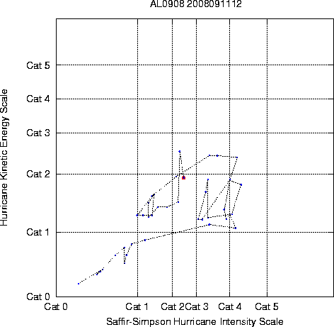
Here is a graph similar to what Masters was talking about re: Kinetic Energy. As you can see, Ike's current Kinetic Energy at Cat 2 Saffir-Simpson winds is on the same level as when he was a Cat 4 but smaller east of Florida:

Multiplatform Tropical Cyclone Kinetic Energy and Intensity (12z):

Image

Loop (scroll down for it):

http://rammb.cira.colostate.edu/product ... r=AL092008
0 likes   

User avatar
Steve
S2K Supporter
S2K Supporter
Posts: 9621
Joined: Sat Apr 05, 2003 11:41 pm
Location: Not a state-caster

#9153 Postby Steve » Thu Sep 11, 2008 12:19 pm

>>Actually Ike did this off Cuba where what appeared to be an Eye rotated. Could it be the inner eye rotating around the outer eye?

Sometimes when you mix two colors of paint you get a swirl where there is a distinct middle. Sometimes you might have white and blue paint pinwheeling into a general central area. Really hard to tell. FUNKTOP IR from the NOAA/SSD site does show convection building to that "spot's" east and around it, but like you said, it may just be an inner swirl rotating within a broader area of circulation and may or may not be a "center" or vortmax itself. I'm thinking they'll unravel some of these issues with Ike down the road when it's researched beyond the threat it poses now. Pretty cool to watch though.

Steve
Last edited by Steve on Thu Sep 11, 2008 12:21 pm, edited 1 time in total.
0 likes   

jinftl
Category 5
Category 5
Posts: 4312
Joined: Tue Aug 31, 2004 4:47 pm
Location: fort lauderdale, fl

Re:

#9154 Postby jinftl » Thu Sep 11, 2008 12:19 pm

This appearance suggests the back half of the storm (right side in this case) would have much more convection and probably worse weather...lasting for a longer time. Maybe the worst conditions will be a few hours later in arriving...esp if not all of the winds are translating to the surface since the somewhat less intense looking right half would be the first to arrive?

On the flip side, the water will be rising long before landfall on the coast as the storm pushes the water in around its circulation.

HURAKAN wrote:Image
0 likes   

THead
S2K Supporter
S2K Supporter
Posts: 790
Joined: Mon Aug 30, 2004 5:09 pm
Location: Lauderhill, Fla./Jefferson, Ga.

Re: ATL IKE: Category 2 - Discussion

#9155 Postby THead » Thu Sep 11, 2008 12:20 pm

Ed Mahmoud wrote:If Ike landfalls with much higher flight level winds than down at the surface, I'd imagine that would be the kind of low level helicity that might really spark a tornado outbreak.

Unofficially, that is.


Yeah, I'm worried about that possibility. Another reason not to split hairs over Cat?. There are plenty of other serious threats/possibilities to worry about and prepare for.
0 likes   

tolakram
Admin
Admin
Posts: 20012
Age: 62
Joined: Sun Aug 27, 2006 8:23 pm
Location: Florence, KY (name is Mark)

Re: ATL IKE: Category 2 - Discussion

#9156 Postby tolakram » Thu Sep 11, 2008 12:20 pm

As far as the possible eye goes, you can see in this rapid scan image that it quickly closes up and doesn't appear to be near the center of circulation.

http://rammb.cira.colostate.edu/ramsdis ... so_4km_ir3
0 likes   

HurricaneRobert
Category 3
Category 3
Posts: 812
Joined: Fri May 18, 2007 9:31 pm

Re: ATL IKE: Category 2 - Discussion

#9157 Postby HurricaneRobert » Thu Sep 11, 2008 12:20 pm

How would a tornado maintain itself under hurricane conditions? They're frequent, but short-lived, which is why I thought they happened often in places far from the center.
0 likes   

User avatar
tailgater
S2K Supporter
S2K Supporter
Posts: 3339
Joined: Sun Jul 11, 2004 9:13 pm
Location: St. Amant La.

Re:

#9158 Postby tailgater » Thu Sep 11, 2008 12:20 pm

Steve wrote:>>that open spot appears on the water vapor as well

Let me speculate this, and that's all it is is rogue, amateur speculation. But if we do get a 30-40 mile wide eye, that's pretty anomalous in the Gulf. Wilma was one of the few storms I can recall in the Gulf as it headed NE/ENE across south Florida that had a massive eye. I have no idea what the intensity will be at landfall, and I'm not going there. But if the eye or even outer eyewall is very large, then it would stand to reason that there would be a larger area of immediate damage due to the inner portion of Hurricane Ike. It's one thing if you've got a 8-12 mile wide eye encircled by the strongest winds and convection a storm has to offer. It's quite another thing if it is significantly larger. So it would be my guess than rather than a 20-25 mile swath of super strong wind damage at landfall, it could cover a wider area if the circumference of the "eyewall" (or center of convection, or whatever they choose to call it with Ike down the road) is substantially larger.

Again, not saying anything "x" is going to happen. Just an interested observer likely to see some TS conditions up my way observing some curiosities unique to Ike and trying to learn from them.

Steve

Looking at numerous sat loops I 'd say dry slot that is staying on western edge of eye wall(strange) but if you look closely at Visible loop( Hi Res)you can see clouds moving south on the eastern edge of dry slot.
0 likes   

CrazyC83
Professional-Met
Professional-Met
Posts: 34002
Joined: Tue Mar 07, 2006 11:57 pm
Location: Deep South, for the first time!

#9159 Postby CrazyC83 » Thu Sep 11, 2008 12:21 pm

Ike is in a cool eddy right now so I don't see much - if any - strengthening until this evening.
0 likes   

curtadams
S2K Supporter
S2K Supporter
Posts: 1122
Joined: Sun Aug 28, 2005 7:57 pm
Location: Orange, California
Contact:

#9160 Postby curtadams » Thu Sep 11, 2008 12:22 pm

The "eye" isn't the eye, or at least not exactly. It's offcenter and the inner eyewall isn't dead yet - you can see the cold convection from its remnants, also offcentered. The "eye" is the moat between the inner and outer walls opening up. It's the beginning of the future eye, if Ike can indeed ever finish his now 5-day ERC, but it's not at the center and it's not part of a complete eye.

Ike is reminding me of Rita with mid-level dry air, being sheared in under the outflow (and hence not directly visible on sat) preventing the ERC from finishing and deflating the storm. That's a *good* way to be reminded of Rita, although even the best-case outcome now is Isabel-level damage due to the massive surge being set up.
0 likes   


Return to “2008”

Who is online

Users browsing this forum: No registered users and 0 guests