ATL: IKE Discussion

Moderator: S2k Moderators

Message
Author
kurtpage
Tropical Storm
Tropical Storm
Posts: 228
Joined: Tue Sep 20, 2005 11:16 pm
Location: Texas

Re: Re:

#12461 Postby kurtpage » Sat Sep 13, 2008 12:56 am

fasterdisaster wrote:
capepoint wrote:reporters on galveston seawall now in eye.


There aren't any reporters on the seawall, as was said they are all several feet above it.


Again...splitting hairs. I think that we all knew what capepoint was saying.

I hope that none of the reporters are injured while reporting for this storm....
Last edited by kurtpage on Sat Sep 13, 2008 12:57 am, edited 1 time in total.
0 likes   

jimguru
S2K Supporter
S2K Supporter
Posts: 50
Joined: Sun Aug 31, 2008 12:50 am
Location: Centralia, Washington
Contact:

Re: ATL IKE: Category 2 - Discussion

#12462 Postby jimguru » Sat Sep 13, 2008 12:56 am

johngaltfla wrote:
fasterdisaster wrote:
bighaben wrote:what about reverse surge, once the storm passes, the water would be coming out of the bay onto the unprotected backside of GI, I've heard it happened in a past hurricane, what are the chances of that happening? If that happens the seawall is useless.


I think Steve Lyons was talking about this happening? Does someone know exactly what he was talking about?


NHC just had someone on MSNBC; apparently everyone forgot that the backside of the storm will overflow the island from the other direction when it passes north of Houston and the wind changes direction. Add in the water that is in the bay has to go somewhere when the winds reverse direction and he made perfect sense. Wish I had caught his name.


So in theory when the surge reverses, it could suck alot of things / people out to sea? ( in theory?)
0 likes   

User avatar
cycloneye
Admin
Admin
Posts: 145351
Age: 68
Joined: Thu Oct 10, 2002 10:54 am
Location: San Juan, Puerto Rico

Re: ATL IKE: Category 2 - Discussion

#12463 Postby cycloneye » Sat Sep 13, 2008 12:56 am

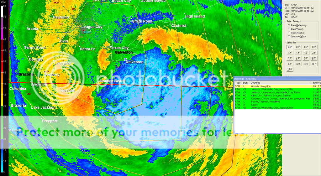
WTNT54 KNHC 130553
TCEAT4
HURRICANE IKE TROPICAL CYCLONE POSITION ESTIMATE
NWS TPC/NATIONAL HURRICANE CENTER MIAMI FL AL092008
100 AM CDT SAT SEP 13 2008

AT 1 AM CDT...0600Z...THE CENTER OF LARGE HURRICANE IKE WAS
ESTIMATED BY NOAA DOPPLER WEATHER RADAR TO BE NEAR LATITUDE 29.0
NORTH...LONGITUDE 94.7 WEST OR ABOUT 20 MILES...35 KM...
SOUTH-SOUTHEAST OF GALVESTON TEXAS. THE NORTHWESTERN PORTION OF THE
EYE SHOULD BE MOVING OVER THE GALVESTON AREA IN THE NEXT HOUR OR
TWO.

THE NATIONAL OCEAN SURFACE STATION AT THE GALVESTON PLEASURE PIER
RECENTLY REPORTED A WIND GUST OF 85 MPH...137 KM/HR.

$$
FORECASTER BEVEN
0 likes   

mtm4319
Category 5
Category 5
Posts: 1537
Joined: Sun Sep 12, 2004 2:47 am
Location: Mobile, AL

#12464 Postby mtm4319 » Sat Sep 13, 2008 12:57 am

0.1 N, 0.2 W in the past hour.
Last edited by mtm4319 on Sat Sep 13, 2008 12:58 am, edited 1 time in total.
0 likes   

soonertwister
Category 5
Category 5
Posts: 1091
Joined: Mon Jun 16, 2003 2:52 pm

Re: ATL IKE: Category 2 - Discussion

#12465 Postby soonertwister » Sat Sep 13, 2008 12:57 am

Aristotle wrote:It looks like the Seawall is doing its job. Geraldo may be there all night. Water is over topping the wall but the surge is not over the wall. Of course it is in the Dead Center of the Eye Wall. So Who knows. When the southern part of the eye wall comes up maybe surge will be worse. I Don't know how that works?


There was definitely a time when the surge was over the seawall, and I'm not convinced it's done. I'm afraid of what we'll see when the first cameras are brought out in the morning.
0 likes   

fasterdisaster
Category 5
Category 5
Posts: 1868
Joined: Mon Sep 19, 2005 4:41 pm
Location: Miami, Florida

Re:

#12466 Postby fasterdisaster » Sat Sep 13, 2008 12:57 am

WxGuy1 wrote:The area from Bolivar Peninsula to Sabine Pass will likely have the strongest winds and highest surge from Ike. What's the highest elevation on B. Peninsula? I have to think that the entire peninsula is experiencing near max wind and max surge, and probability of surviving there if you aren't in a very, very sturdy, reinforced building, I fear, is going to be tough.


According to GE, only about 2 feet.
0 likes   

jlauderdal
S2K Supporter
S2K Supporter
Posts: 7183
Joined: Wed May 19, 2004 5:46 am
Location: NE Fort Lauderdale
Contact:

Re: ATL IKE: Category 2 - Discussion

#12467 Postby jlauderdal » Sat Sep 13, 2008 12:58 am

Image
0 likes   

bighaben
Tropical Low
Tropical Low
Posts: 32
Age: 36
Joined: Sat Aug 30, 2008 1:48 am
Location: The Woodlands, Texas

Re: ATL IKE: Category 2 - Discussion

#12468 Postby bighaben » Sat Sep 13, 2008 12:58 am

jimguru wrote:
So in theory when the surge reverses, it could suck alot of things / people out to sea? ( in theory?)


Perhaps, I know a local met briefly covered it yesterday, but he didn't give any numbers at all! I'm seriously wondering if this is something Galveston really has to watch for and many people may have overlooked.
Last edited by bighaben on Sat Sep 13, 2008 12:58 am, edited 1 time in total.
0 likes   

User avatar
jasons2k
Storm2k Executive
Storm2k Executive
Posts: 8245
Age: 51
Joined: Wed Jul 06, 2005 12:32 pm
Location: The Woodlands, TX

Re: ATL IKE: Category 2 - Discussion

#12469 Postby jasons2k » Sat Sep 13, 2008 12:58 am

kurtpage wrote:
fasterdisaster wrote:
bighaben wrote:what about reverse surge, once the storm passes, the water would be coming out of the bay onto the unprotected backside of GI, I've heard it happened in a past hurricane, what are the chances of that happening? If that happens the seawall is useless.


I think Steve Lyons was talking about this happening? Does someone know exactly what he was talking about?


From what I understand...Galveston Bay will flood into the backside of Galveston when the winds change direction...


It's the other way around. Winds have been from the N & NE, almost parallel to the coast but bringing-in surge from the backside. Assuming this west wobble holds, after the eye passes, winds will switch from the south (onshore flow), and that's when the major surge will occur.

But if Ike takes another wobble east, that may not happen. It's very, very close.
0 likes   

jinftl
Category 5
Category 5
Posts: 4312
Joined: Tue Aug 31, 2004 4:47 pm
Location: fort lauderdale, fl

Re: ATL IKE: Category 2 - Discussion

#12470 Postby jinftl » Sat Sep 13, 2008 12:58 am

Dr, Lyons said worst winds and damage will be from east end of galveston and east of there. Also said if circulation stays just to the east of houston, they will not see the worst, esp west side. But still no picnic.


johngaltfla wrote:
fasterdisaster wrote:
bighaben wrote:what about reverse surge, once the storm passes, the water would be coming out of the bay onto the unprotected backside of GI, I've heard it happened in a past hurricane, what are the chances of that happening? If that happens the seawall is useless.


I think Steve Lyons was talking about this happening? Does someone know exactly what he was talking about?


NHC just had someone on MSNBC; apparently everyone forgot that the backside of the storm will overflow the island from the other direction when it passes north of Houston and the wind changes direction. Add in the water that is in the bay has to go somewhere when the winds reverse direction and he made perfect sense. Wish I had caught his name.
0 likes   

capepoint
Category 1
Category 1
Posts: 415
Joined: Sat Jul 19, 2008 7:13 pm
Location: Beaufort, NC

Re: Re:

#12471 Postby capepoint » Sat Sep 13, 2008 12:58 am

fasterdisaster wrote:
capepoint wrote:reporters on galveston seawall now in eye.


There aren't any reporters on the seawall, as was said they are all several feet above it.


excuse me. I should have said that the reporters standing on the base of the hill across the flooded roadway from the seawall are in the eye now. 70 or 80 feet IS a huge distance..... :roll:
0 likes   

User avatar
Aristotle
Tropical Storm
Tropical Storm
Posts: 141
Age: 59
Joined: Wed Aug 27, 2008 8:16 pm
Location: Crowley, TX

Re: Re:

#12472 Postby Aristotle » Sat Sep 13, 2008 12:59 am

fasterdisaster wrote:
capepoint wrote:reporters on galveston seawall now in eye.


There aren't any reporters on the seawall, as was said they are all several feet above it.


Dude take a chill pill NO ONE on this board actually thinks Geraldo and the rest of the reports are actually standing on the 17 precipice waiting to be sucked out to sea. WE all get that they are across the street from the Seawall. Please take anyone saying "Reporter at the Seawall" to mean someone referring to a reporter reporting at, near or generally close to the actual Seawall. Saavy?
0 likes   

mtm4319
Category 5
Category 5
Posts: 1537
Joined: Sun Sep 12, 2004 2:47 am
Location: Mobile, AL

Re: Re:

#12473 Postby mtm4319 » Sat Sep 13, 2008 12:59 am

fasterdisaster wrote:
WxGuy1 wrote:The area from Bolivar Peninsula to Sabine Pass will likely have the strongest winds and highest surge from Ike. What's the highest elevation on B. Peninsula? I have to think that the entire peninsula is experiencing near max wind and max surge, and probability of surviving there if you aren't in a very, very sturdy, reinforced building, I fear, is going to be tough.


According to GE, only about 2 feet.


I'm not sure if Google Earth is foolproof in this case, but I did find some 6-foot spots.
0 likes   

User avatar
fci
S2K Supporter
S2K Supporter
Posts: 3324
Joined: Tue Sep 14, 2004 10:29 am
Location: Lake Worth, FL

#12474 Postby fci » Sat Sep 13, 2008 1:00 am

Watching Fox is like passing an accident.
You just have to look.
Even though you don't want to.
It is horrific but you feel compelled to see it.

He asked their on air Met if it was true what he heard that after the eye passed the winds would come from the other direction.

She DID NOT KNOW!!!

She said, I guess we will see since things are counterclockwise.

Quite the Met, I would say.

Like I said, the coverage on KHOU (DirecTV feed), CNN, TWC and MSNBC is so much better but it is like watching the circus when you watch the swath of miss-information from Geraldo and Friends.....
0 likes   

jinftl
Category 5
Category 5
Posts: 4312
Joined: Tue Aug 31, 2004 4:47 pm
Location: fort lauderdale, fl

Re: ATL IKE: Category 2 - Discussion

#12475 Postby jinftl » Sat Sep 13, 2008 1:00 am

There's the 137! km/hr that is

fasterdisaster wrote:
cycloneye wrote:WTNT54 KNHC 130553
TCEAT4
HURRICANE IKE TROPICAL CYCLONE POSITION ESTIMATE
NWS TPC/NATIONAL HURRICANE CENTER MIAMI FL AL092008
100 AM CDT SAT SEP 13 2008

AT 1 AM CDT...0600Z...THE CENTER OF LARGE HURRICANE IKE WAS
ESTIMATED BY NOAA DOPPLER WEATHER RADAR TO BE NEAR LATITUDE 29.0
NORTH...LONGITUDE 94.7 WEST OR ABOUT 20 MILES...35 KM...
SOUTH-SOUTHEAST OF GALVESTON TEXAS. THE NORTHWESTERN PORTION OF THE
EYE SHOULD BE MOVING OVER THE GALVESTON AREA IN THE NEXT HOUR OR
TWO.

THE NATIONAL OCEAN SURFACE STATION AT THE GALVESTON PLEASURE PIER
RECENTLY REPORTED A WIND GUST OF 85 MPH...137 KM/HR.

$$
FORECASTER BEVEN


I'm sorry, but am I the only one amused there is a place off the Texas coast called "Pleasure Pier" and, especially, "Pleasure Island"?
0 likes   

fasterdisaster
Category 5
Category 5
Posts: 1868
Joined: Mon Sep 19, 2005 4:41 pm
Location: Miami, Florida

Re: ATL IKE: Category 2 - Discussion

#12476 Postby fasterdisaster » Sat Sep 13, 2008 1:00 am

jasons wrote:It's the other way around. Winds have been from the N & NE, almost parallel to the coast but bringing-in surge from the backside. Assuming this west wobble holds, after the eye passes, winds will switch from the south (onshore flow), and that's when the major surge will occur.

But if Ike takes another wobble east, that may not happen. It's very, very close.


You might already know this, but you're about to get hit by the core winds and rain.
0 likes   

Derek Ortt

Re:

#12477 Postby Derek Ortt » Sat Sep 13, 2008 1:01 am

Extremeweatherguy wrote:---


the strongest winds are to the east of the eye. They wont move onshore for a few more hours
0 likes   

jimguru
S2K Supporter
S2K Supporter
Posts: 50
Joined: Sun Aug 31, 2008 12:50 am
Location: Centralia, Washington
Contact:

Re: ATL IKE: Category 2 - Discussion

#12478 Postby jimguru » Sat Sep 13, 2008 1:01 am

Stream on ABC13 showing the restaurant fire now....
0 likes   

fasterdisaster
Category 5
Category 5
Posts: 1868
Joined: Mon Sep 19, 2005 4:41 pm
Location: Miami, Florida

Re: ATL IKE: Category 2 - Discussion

#12479 Postby fasterdisaster » Sat Sep 13, 2008 1:02 am

Jijenji wrote:Guys the water will be the highest around high tide, which is 2-3 hours from now. Also, I'm not sure they're completely into the eye yet based on the last radar imagery although it looks close.

http://radar.weather.gov/radar.php?rid= ... 11&loop=no


Unfortunately, high tide is going to be right when the reverse surge could hit. :cry:
0 likes   

User avatar
johngaltfla
Category 5
Category 5
Posts: 2069
Joined: Sun Jul 10, 2005 9:17 pm
Location: Sarasota County, FL
Contact:

Re: ATL IKE: Category 2 - Discussion

#12480 Postby johngaltfla » Sat Sep 13, 2008 1:02 am

KRIV-Houston just updated:

20 miles SSE of Galveston, moving NW at 12. So the wobble was just that.

Houston may not get the worst, but the winds when whipped between those buildings will not be a pretty sight.
0 likes   


Return to “2008”

Who is online

Users browsing this forum: No registered users and 8 guests