SouthFloridawx wrote:

Landfall or is the center south of what appears to be that eye?
Moderator: S2k Moderators

SouthFloridawx wrote:
fasterdisaster wrote:mathwhizz wrote:The "wobbles" people seem to be jumping on are looking to me as contractions of the eyewall
The path of the storm of itself is not changing to a great deal... it's basically following the NHC track, if not a little SouthWest of it
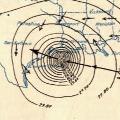
Yes, this is what I see too. It's gone from an 80 mile wide eye to about 30 miles.
I don't think so, tolakram's actually been plotting the center given by the NHC each advisory and he has been alternating between almost due north and almost due west. Right now after a north jog he looks to again be turning towards the WNW to NW
SouthFloridawx wrote:


fasterdisaster wrote:mathwhizz wrote:The "wobbles" people seem to be jumping on are looking to me as contractions of the eyewall
The path of the storm of itself is not changing to a great deal... it's basically following the NHC track, if not a little SouthWest of it
Yes, this is what I see too. It's gone from an 80 mile wide eye to about 30 miles.
I don't think so, tolakram's actually been plotting the center given by the NHC each advisory and he has been alternating between almost due north and almost due west. Right now after a north jog he looks to again be turning towards the WNW to NW
CowboyFan wrote:KFDM news just reported 6 feet of water in the downtown courthouse in galveston.
http://www.kfdm.com/


fasterdisaster wrote:
Compare:
Ivan
Rita
Katrina
Wilma
This just HAS to be Category 3.
Deathray wrote:1.3 million + 92,000 people without power already
Surge is also showing up in Galveson Bay
(As said on TV)
Jason_B wrote::eek: At the Clear Lake footage on TWC.

Users browsing this forum: No registered users and 35 guests


