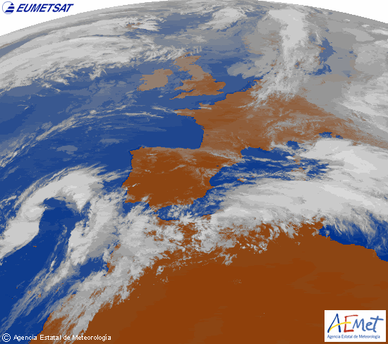
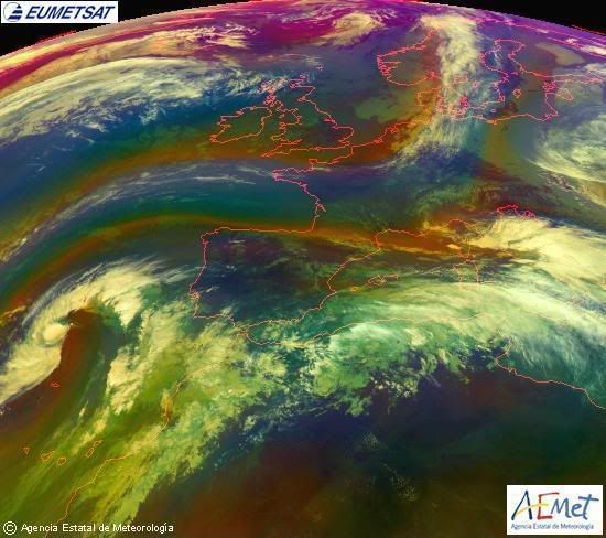
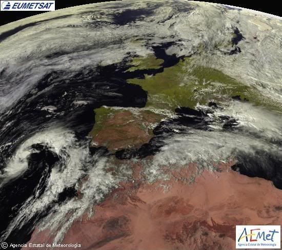
Subtropical Development in the NE Atlantic? New System

This is the general tropical discussion area. Anyone can take their shot at predicting a storms path.

Moderator: S2k Moderators

Forum rules

The posts in this forum are NOT official forecasts and should not be used as such. They are just the opinion of the poster and may or may not be backed by sound meteorological data. They are NOT endorsed by any professional institution or STORM2K. For official information, please refer to products from the National Hurricane Center and National Weather Service.

Help Support Storm2K
Message
Author
User avatar
HURAKAN
Professional-Met
Professional-Met
Posts: 46086
Age: 38
Joined: Thu May 20, 2004 4:34 pm
Location: Key West, FL
Contact:

Subtropical Development in the NE Atlantic? New System

#1 Postby HURAKAN » Fri Sep 19, 2008 9:40 am

Link: http://www.aemet.es/es/eltiempo/observa ... te/visible

Image

Image

Image

Image

Development not likely since it's moving north but looks nice!
0 likes   

User avatar
HURAKAN
Professional-Met
Professional-Met
Posts: 46086
Age: 38
Joined: Thu May 20, 2004 4:34 pm
Location: Key West, FL
Contact:

#2 Postby HURAKAN » Fri Sep 19, 2008 9:43 am

How it looked 6 hours ago:

Image
0 likes   

User avatar
Chacor
Category 5
Category 5
Posts: 10229
Joined: Mon Oct 02, 2006 10:43 pm
Location: Singapore

#3 Postby Chacor » Fri Sep 19, 2008 9:57 am

FQNT50 LFPW 190854

A
SECURITE
Weather bulletin for METAREA 2, METEO-FRANCE,
Toulouse, Friday 19 September 2008 at 09 UTC.

- Wind speed in BEAUFORT SCALE - Sea : Total significant -
- Please be aware, wind gusts can be a further 40 percent stronger
than the averages given here, and maximum waves may be up to twice
the significant height.


Part 1 : WARNING : nr 425.


Part 2 : General synopsis, Friday 19 at 00 UTC

Thundery low 1011 over MADEIRA, moving northwest and deepening,
expected 1010 35N18W by 19/12UTC, then 1007 36N19W by 20/12UTC.

Disturbance crossing FARADAY and Northwest ALTAIR later.
High 1026 just south Ireland moving northeast and building,
expected 1033 just east Netherland by 20/12UTC.
New high expected 1035 46N49W by 20/12UTC.


Tropical wave along 25W/26W south of 18N, moving west 10 kt.
ITCZ along 11N15W 10N18W 12N25W 10N35W.


Part 3 : Area forecasts to Saturday 20 at 12 UTC

FARADAY :
In far southeast, Southerly 3 to 5. Elsewhere, Southerly 3 or 4
gradually veering Northerly 5 or 6. Gusts. Moderate, becoming rough
in northwest. Rain. Fog patches.

ROMEO :
In Northwest: Southerly 3 to 5. In southeast: Easterly 3 to 5.
Moderate.

ALTAIR :
In far southeast, East or Northeast 3 to 5 increasing 4 to 6 later.
Elsewhere, Variable 2 to 4 becoming North or Northeast 4 to 6
later. Gusts. Moderate. Rain or showers.

CHARCOT :
East or Northeast 3 to 5, increasing 5 to 7 in south soon.
Moderate or rough. Showers, locally thundersqualls with severe
gusts from south.

ACORES :
In west: Variable 2 to 4. In east: North or Northeast 4 or 5,
increasing 6 in northeast at end. Moderate, locally rough in east.
Rain and showers, locally thundersqualls with severe gusts.

JOSEPHINE :
In southwest: Cyclonic 6 to 8 decreasing 5 to 7 later. In
northeast, East or Southeast 5 to 7 veering South or Southeast 3
to 5 from south. Moderate or rough. Showers, locally
thundersqualls with severe gusts.

IRVING :
Northerly 3 to 5. Moderate. Rain and showers in east, locally
thundersqualls with severe gust.

MADEIRA :
Cyclonic 6 to 8, but South or Southwest in east and West or
Southwest in south, veering West or Southwest 4 to 6 everywhere
later. Moderate or rough. Showers, locally thundersqualls with
severe gusts.


PAZENN :
East or Northeast 3 to 5, veering East 4 or 5 later. Moderate or
rough in Northwest swell.

IROISE, YEU, ROCHEBONNE :
Northeasterly 3 or 4, veering Easterly 4 or 5 later. Slight or
moderate in Northwest swell. Thundery rain in south.

CANTABRICO :
In west: East or Northeast 3 or 4 veering Easterly 4 or 5 soon. In
east: Northerly 2 to 4 veering East or Northeast overnight. Slight
or moderate in Northwest swell. Thundery rain or showers.

FINISTERRE :
East or Northeast 4 to 6 decreasing 2 to 4 in south later. Moderate
or rough in Northwest swell.

PORTO :
Northeasterly 3 or 4, locally Northerly in far northeast, veering
Easterly soon, and becoming variable 3 to 5 later, Southeasterly
prevailing. Slight increasing moderate. Showers or thundersqualls
with severe gusts.

SAO VICENTE :
East or Southeast 3 to 5, veering Southeasterly soon, occasionally
6 in far southeast, but becoming variable 3 or 4 in east. Slight
or moderate. Showers or thundersqualls with severe gusts.

CADIZ, GIBRALTAR STRAIT :
In and leeward strait, Easterly 3 to 5 increasing 4 to 6 later.
Elsewhere, variable 2 to 4. Smooth to slight, becoming locally
moderate. Showers.

CASABLANCA :
In west, South or Southeast 3 to 5, increasing 4 to 6 soon, and
veering South or Southwest 3 or 4 later. In east, variable 2 to 4.
Slight or moderate. Showers or thundersqualls with severe gusts.

AGADIR :
Variable 3 or 4, mainly Southerly 5 in far northwest. Slight or
moderate. Showers or thundersqualls with severe gusts.


METEOR :
North or Northeast 3 or 4, locally Northwest far northeast.
Moderate in N or NE swell.
Some showers.
CANARIAS :
Mainly Westerly 2 to 4, but South 3 to 5 in northeast until 20/03
UTC, becoming later Northerly in southeast. Slight or moderate in N
swell. Some showers in north, locally thundery in northeast at
first.
TARFAYA :
Becoming North 2 to 4, veering East later, becoming Variable at
end.
Moderate in N swell, abating. Thunderstorms, decerasing later.
CAPE VERDE, CAP BLANC :
North or Northeast 3 or 4, locally Variable 2 or 3 in north of CAP
BLANC at first.
Moderate in N or NE swell. Some showers in CAPE VERDE.


CAP TIMIRIS :
North 3 or 4, increasing later 4 or 5. Moderate. N swell.
SIERRA LEONE :
Variable 2 to 4, but Northeast in northwest. Moderate in S or SE
swell.
Thundersqualls with severe gusts, mainly in southeast.
GULF OF GUINEA :
Southerly 3 to 5, locally 6. Moderate in S swell. Thundersqualls
with severe gusts.
POINTE NOIRE :
South or Southeast 3 to 5, but Variable 1 to 3 far east. Moderate
in S swell.


Part 4 : outlook for next 24 hours :

Persistence of thundery low southwest of JOSEPHINE with threat of
near gale or gale in CHARCOT, JOSEPHINE and MADEIRA. Elsewhere, ni
gale expected.
0 likes   
User avatar
HURAKAN
Professional-Met
Professional-Met
Posts: 46086
Age: 38
Joined: Thu May 20, 2004 4:34 pm
Location: Key West, FL
Contact:

#4 Postby HURAKAN » Fri Sep 19, 2008 11:52 am

Image
0 likes   

User avatar
DESTRUCTION5
Category 5
Category 5
Posts: 4423
Age: 43
Joined: Wed Sep 03, 2003 11:25 am
Location: Stuart, FL

#5 Postby DESTRUCTION5 » Fri Sep 19, 2008 11:54 am

Humm...Could we have Kyle in a unlikley spot here?
0 likes   

User avatar
HURAKAN
Professional-Met
Professional-Met
Posts: 46086
Age: 38
Joined: Thu May 20, 2004 4:34 pm
Location: Key West, FL
Contact:

#6 Postby HURAKAN » Fri Sep 19, 2008 11:56 am

Image

12Z: Stationary, interesting.
0 likes   

User avatar
Category 5
Category 5
Category 5
Posts: 10074
Age: 35
Joined: Sun Feb 11, 2007 10:00 pm
Location: New Brunswick, NJ
Contact:

Re: Subtropical Development in the NE Atlantic?

#7 Postby Category 5 » Fri Sep 19, 2008 12:12 pm

You never know, you just never know. It surely is interesting.
0 likes   

User avatar
HURAKAN
Professional-Met
Professional-Met
Posts: 46086
Age: 38
Joined: Thu May 20, 2004 4:34 pm
Location: Key West, FL
Contact:

#8 Postby HURAKAN » Fri Sep 19, 2008 12:22 pm

In case you say that storms never develop here:

Image

Image

Image

Image

Image
0 likes   

User avatar
HURAKAN
Professional-Met
Professional-Met
Posts: 46086
Age: 38
Joined: Thu May 20, 2004 4:34 pm
Location: Key West, FL
Contact:

#9 Postby HURAKAN » Fri Sep 19, 2008 12:28 pm

Image

Sun coming down but the disturbance is looking a little better.
0 likes   

User avatar
DESTRUCTION5
Category 5
Category 5
Posts: 4423
Age: 43
Joined: Wed Sep 03, 2003 11:25 am
Location: Stuart, FL

Re:

#10 Postby DESTRUCTION5 » Fri Sep 19, 2008 12:38 pm

HURAKAN wrote:Image

Sun coming down but the disturbance is looking a little better.


Saw this being persistant on GFS and thought we may see at least some attention paid..
0 likes   

User avatar
HURAKAN
Professional-Met
Professional-Met
Posts: 46086
Age: 38
Joined: Thu May 20, 2004 4:34 pm
Location: Key West, FL
Contact:

#11 Postby HURAKAN » Fri Sep 19, 2008 1:48 pm

Image

Image

Not much movement expected in the next 24 hours.
0 likes   

Cyclone1
Category 5
Category 5
Posts: 2739
Age: 33
Joined: Tue Jun 12, 2007 12:03 pm
Location: Florida

#12 Postby Cyclone1 » Fri Sep 19, 2008 5:05 pm

Oh wow... I could definitely see this becoming Kyle... Deserves watching at least. Nice catch, Sandy!
0 likes   

User avatar
HURAKAN
Professional-Met
Professional-Met
Posts: 46086
Age: 38
Joined: Thu May 20, 2004 4:34 pm
Location: Key West, FL
Contact:

#13 Postby HURAKAN » Fri Sep 19, 2008 5:35 pm

:uarrow: This season we have not seen any subtropical development in the Atlantic Ocean itself (Edouard was in the GOM). I have been thinking on doing a thread talking about it but didn't think it would attract much public!

This system is interesting but I don't expect any real development. I have been surprised before and it's September! Lets see what happens.
0 likes   

User avatar
HURAKAN
Professional-Met
Professional-Met
Posts: 46086
Age: 38
Joined: Thu May 20, 2004 4:34 pm
Location: Key West, FL
Contact:

#14 Postby HURAKAN » Fri Sep 19, 2008 8:21 pm

Image

Image
0 likes   

Matt-hurricanewatcher

Re: Subtropical Development in the NE Atlantic?

#15 Postby Matt-hurricanewatcher » Fri Sep 19, 2008 8:28 pm

This don't have much chance. I'm not going to fly the freak flag after a "invest" last year that looked better having not being upgraded. I'm sorry, but it won't happen. If it does then I will say I'm wrong.

It does look pretty good, it has to loose that frontal thing, but other wise looks good.
0 likes   

Matt-hurricanewatcher

Re: Subtropical Development in the NE Atlantic?

#16 Postby Matt-hurricanewatcher » Fri Sep 19, 2008 8:39 pm

This needs to be Invest 94L...That is all I'm going to say.
0 likes   

User avatar
HURAKAN
Professional-Met
Professional-Met
Posts: 46086
Age: 38
Joined: Thu May 20, 2004 4:34 pm
Location: Key West, FL
Contact:

#17 Postby HURAKAN » Fri Sep 19, 2008 8:40 pm

Image

Image

Matt, I agree. It looks pretty darn good but not tropical enough to be subtropical. It has about 24 hours. Lets see.
0 likes   

Matt-hurricanewatcher

Re: Subtropical Development in the NE Atlantic?

#18 Postby Matt-hurricanewatcher » Fri Sep 19, 2008 8:55 pm

I think its borderline...If it can develop convection over the center, then it could become one. I believe the nhc needs to put it under a yellow or maybe a orange.
0 likes   

User avatar
HURAKAN
Professional-Met
Professional-Met
Posts: 46086
Age: 38
Joined: Thu May 20, 2004 4:34 pm
Location: Key West, FL
Contact:

#19 Postby HURAKAN » Fri Sep 19, 2008 8:59 pm

Image

LAIP5 - MARITIME-ship
Saturday Sep. 20 - 0:00 UTC

Air Temperature: 68°F
Dewpoint: 66°F
Wind: E at 34 mph
Pressure: 1012.6 mb
Weather: Thunderstorms
Wave Height: 5 ft
Sea Surface Temp: 69.8°F

Strong winds being reported near the LLC. A plus for subtropical-ization!
0 likes   

Matt-hurricanewatcher

Re:

#20 Postby Matt-hurricanewatcher » Fri Sep 19, 2008 9:02 pm

HURAKAN wrote:Image

LAIP5 - MARITIME-ship
Saturday Sep. 20 - 0:00 UTC

Air Temperature: 68°F
Dewpoint: 66°F
Wind: E at 34 mph
Pressure: 1012.6 mb
Weather: Thunderstorms
Wave Height: 5 ft
Sea Surface Temp: 69.8°F

Strong winds being reported near the LLC. A plus for subtropical-ization!


Very borderline sst's for subtropical development. I believe if it can develop that burst of convection near its center, it will be a subtropical system. But I don't think this has a chance of becoming more.
0 likes   


Return to “Talkin' Tropics”

Who is online

Users browsing this forum: Cpv17, Hurricane2022, Ian2401 and 46 guests