Without a doubt 93L is reorganizing...and quickly...I believe this will be a named storm..albeit probably short living because of increasing shear.
Of course...it is highly uncertsin whether 93L will actually be classified...if anything it should at least organize unto a Depression overnight.
ATL: Tropical Storm Kyle : Discussion
Moderator: S2k Moderators
-
jconsor
- Professional-Met

- Posts: 581
- Joined: Mon Jun 30, 2008 9:31 pm
- Location: Jerusalem, Israel
- Contact:
Re:
This once again shows how NHC is not always objective when classifying tropical cyclones. Recon shows a well-defined circulation with pressure around 1004 mb, flight level winds of 40 kt, SFMR winds over 50 kt. Satellite shows convection increasing dramatically (though still mostly in the eastern semicircle) in the past 12 hours, and yet they refuse to upgrade it.
0 likes
-
Matt-hurricanewatcher
Re: Re:
jconsor wrote:This once again shows how NHC is not always objective when classifying tropical cyclones. Recon shows a well-defined circulation with pressure around 1004 mb, flight level winds of 40 kt, SFMR winds over 50 kt. Satellite shows convection increasing dramatically (though still mostly in the eastern semicircle) in the past 12 hours, and yet they refuse to upgrade it.
I agree...I don't expect them to upgrade intil at least 5pm at the earliest.
0 likes
-
AJC3

- Admin

- Posts: 4156
- Age: 62
- Joined: Tue Aug 31, 2004 7:04 pm
- Location: Ballston Spa, New York
- Contact:
Re: Re:
jconsor wrote:This once again shows how NHC is not always objective when classifying tropical cyclones. Recon shows a well-defined circulation with pressure around 1004 mb, flight level winds of 40 kt, SFMR winds over 50 kt. Satellite shows convection increasing dramatically (though still mostly in the eastern semicircle) in the past 12 hours, and yet they refuse to upgrade it.
I think their conservative approach yielded the correct call when it came to NOT declaring 94L an STS this afternoon, despite the protests and second-guessing of some. RECON showed a cyclone with a XT structure. Let's give 93L a few more hours - if it maintains the trend toward improving organization, then I'm sure it will be upgraded. Until then, lets not jump on the bandwagon so early again.
0 likes


Re: ATL INVEST 93L: Discussion
000
ABNT20 KNHC 250545
TWOAT
TROPICAL WEATHER OUTLOOK
NWS TPC/NATIONAL HURRICANE CENTER MIAMI FL
200 AM EDT THU SEP 25 2008
FOR THE NORTH ATLANTIC...CARIBBEAN SEA AND THE GULF OF MEXICO...
A WELL-DEFINED SURFACE LOW PRESSURE SYSTEM CENTERED ABOUT 225 MILES
SOUTHEAST OF THE SOUTH CAROLINA-NORTH CAROLINA BORDER IS MOVING
SLOWLY WESTWARD. SHOWERS AND THUNDERSTORMS HAVE BECOME A LITTLE
BETTER ORGANIZED THIS MORNING AND THIS SYSTEM COULD DEVELOP INTO A
SUBTROPICAL OR TROPICAL CYCLONE LATER TODAY. REGARDLESS OF WHETHER
OR NOT THIS SYSTEM BECOMES A SUBTROPICAL OR TROPICAL CYCLONE...
STRONG WINDS...COASTAL FLOODING...HIGH SURF...AND DANGEROUS RIP
CURRENTS WILL CONTINUE ALONG PORTIONS OF THE U.S. EAST COAST DURING
THE NEXT COUPLE OF DAYS. OUTER RAINBANDS ARE ALREADY SPREADING
ONSHORE THE SOUTHEASTERN COAST OF NORTH CAROLINA...AND BUOY AND
SHIP REPORTS INDICATE WINDS IN EXCESS OF 50 MPH ARE OCCURRING NORTH
AND WEST OF THE CENTER. INTERESTS ALONG THE U.S. EAST COAST FROM
THE CAROLINAS NORTHWARD TO MID-ATLANTIC REGION SHOULD CLOSELY
MONITOR STATEMENTS FROM THEIR LOCAL NATIONAL WEATHER SERVICE
FORECAST OFFICES...AND ALSO HIGH SEAS FORECASTS ISSUED BY THE OCEAN
PREDICTION CENTER IN WASHINGTON D.C. FOR ADDITIONAL INFORMATION AND
WARNINGS.
ANOTHER WELL-DEFINED LOW PRESSURE SYSTEM CENTERED ABOUT 140 MILES
EAST-NORTHEAST OF THE TURKS AND CAICOS ISLANDS IS MOVING NORTHWARD
AT 10 TO 15 MPH. THUNDERSTORM ACTIVITY HAS INCREASED AND BECOME
BETTER ORGANIZED DURING THE PAST SEVERAL HOURS...AND UPPER-LEVEL
WINDS ARE EXPECTED TO GRADUALLY BECOME MORE FAVORABLE FOR A
TROPICAL DEPRESSION TO DEVELOP DURING THE NEXT DAY OR SO. IN
ADDITION...THE THREAT FOR HEAVY RAINFALL AND ASSOCIATED FLOODS AND
MUD SLIDES OVER HISPANIOLA...PUERTO RICO... AND THE VIRGIN ISLANDS
WILL CONTINUE THROUGH TODAY.
ELSEWHERE...TROPICAL CYCLONE FORMATION IS NOT EXPECTED DURING THE
NEXT 48 HOURS.
$$
FORECASTER STEWART
0 likes
-
Matt-hurricanewatcher
Re: ATL INVEST 93L: Discussion
Let me take my weird cap off and put on my hurricane tracker cap on.
Ok, this is a TROPICAL STORM based on data shown by recon last night. It has a closed LLC with some data showing 40 mph winds at the surface. It is likely stronger now with the deeper convection. THIS IS NOT 94L which had tryed to form a warm core yesterday morning, but failed to do so, that is why the convection died down. Now it is coming back in a more classic subtropical formation. I finally think it has formed enough of a warm core to be upgraded to. That is all...
Ok, this is a TROPICAL STORM based on data shown by recon last night. It has a closed LLC with some data showing 40 mph winds at the surface. It is likely stronger now with the deeper convection. THIS IS NOT 94L which had tryed to form a warm core yesterday morning, but failed to do so, that is why the convection died down. Now it is coming back in a more classic subtropical formation. I finally think it has formed enough of a warm core to be upgraded to. That is all...
0 likes
-
AJC3
- Admin
- Posts: 4156
- Age: 62
- Joined: Tue Aug 31, 2004 7:04 pm
- Location: Ballston Spa, New York
- Contact:
Re: ATL INVEST 93L: Discussion
Matt-hurricanewatcher wrote:Let me take my weird cap off and put on my hurricane tracker cap on.
Ok, this is a TROPICAL STORM based on data shown by recon last night. It has a closed LLC with some data showing 40 mph winds at the surface. It is likely stronger now with the deeper convection. THIS IS NOT 94L which had tryed to form a warm core yesterday morning, but failed to do so, that is why the convection died down. Now it is coming back in a more classic subtropical formation. I finally think it has formed enough of a warm core to be upgraded to. That is all...
1. The central convection in the gale center that is 94L died off because dry stable air wrapped into it's core. In the opinon of NHC, HPC and OPC, it never shed it's frontal structure yesterday. I agree with that assessment, although it looks as though as of now an occlusion has pretty much completely wrapped around the cyclone.
2. My making an analogy to 94L should not be construed in any way by anyone that I think it is similar in structure to 93L. It's simply an observation that the conservative tack NHC uses is, more often than not, superior to the immediate calls for upgrades that seem to so often pervade this board.
0 likes
-
Matt-hurricanewatcher
Re: ATL INVEST 93L: Discussion
AJC3 wrote:Matt-hurricanewatcher wrote:Let me take my weird cap off and put on my hurricane tracker cap on.
Ok, this is a TROPICAL STORM based on data shown by recon last night. It has a closed LLC with some data showing 40 mph winds at the surface. It is likely stronger now with the deeper convection. THIS IS NOT 94L which had tryed to form a warm core yesterday morning, but failed to do so, that is why the convection died down. Now it is coming back in a more classic subtropical formation. I finally think it has formed enough of a warm core to be upgraded to. That is all...
1. The central convection in the gale center that is 94L died off because dry stable air wrapped into it's core. In the opinon of NHC, HPC and OPC, it never shed it's frontal structure. I agree with that assessment.
2. My making an analogy to 94L should not be construed in any way by anyone that I think it is similar in structure to 93L. It's simply an observation that the conservative tack NHC uses is, more often than not, superior to the immediate calls for upgrades that seem to so often pervade this board.
1# You have a point in that it was to early to upgrade this morning, so the convection more or less got kicked down as fast as it went up. This time we will see if it can finally form that warm core.
2# Recon shown a well defined and closed LLC, with data to support at least 30-35 knot surface winds. You can't say that some of the data did show that. Maybe you could
So at the end of the day I believe soildly if the recon data has in vaild reason to be true that this system is likely a cyclone.(93L). Again, who really knows any more.
0 likes
Re: ATL INVEST 93L: Discussion
000
WONT41 KNHC 250837
DSAAT
SPECIAL TROPICAL DISTURBANCE STATEMENT
NWS TPC/NATIONAL HURRICANE CENTER MIAMI FL
435 AM EDT THU SEP 25 2008
A WELL-DEFINED EXTRATROPICAL LOW PRESSURE SYSTEM CENTERED ABOUT 225
MILES SOUTHEAST OF THE SOUTH CAROLINA-NORTH CAROLINA BORDER IS
MOVING WEST-NORTHWESTWARD AT 5 TO 10 MPH. SHOWERS AND THUNDERSTORMS
ARE GRADUALLY BECOMING BETTER ORGANIZED AND THIS SYSTEM COULD
DEVELOP INTO A SUBTROPICAL OR TROPICAL CYCLONE BEFORE THE SYSTEM
MOVES INLAND ALONG THE ALONG THE SOUTHEASTERN U.S. COAST ON FRIDAY.
REGARDLESS OF WHETHER OR NOT THIS SYSTEM BECOMES A SUBTROPICAL OR
TROPICAL CYCLONE... STRONG WINDS...COASTAL FLOODING...HIGH SURF...
AND DANGEROUS RIP CURRENTS WILL CONTINUE ALONG PORTIONS OF THE
SOUTHEASTERN AND MID-ATLANTIC U.S. COASTAL REGIONS DURING THE NEXT
COUPLE OF DAYS. OUTER RAINBANDS CONTINUE TO SPREAD ONSHORE THE
NORTH CAROLINA COAST THIS MORNING...AND BUOY AND SHIP REPORTS
INDICATE WINDS IN EXCESS OF 50 MPH ARE OCCURRING MORE THAN 100
MILES FORM THE CENTER. AN AIR FORCE RESERVE UNIT RECONNAISSANCE
AIRCRAFT SCHEDULED TO INVESTIGATE THE SYSTEM LATER THIS MORNING
WILL PROVIDE BETTER INFORMATION ON ITS STRUCTURE AND INTENSITY.
INTERESTS ALONG THE U.S. EAST COAST FROM THE CAROLINAS NORTHWARD TO
MID-ATLANTIC REGION SHOULD CLOSELY MONITOR STATEMENTS FROM THEIR
LOCAL NATIONAL WEATHER SERVICE FORECAST OFFICES...AND ALSO HIGH
SEAS FORECASTS ISSUED BY THE OCEAN PREDICTION CENTER IN WASHINGTON
D.C. FOR ADDITIONAL INFORMATION AND WARNINGS.
ANOTHER LOW PRESSURE SYSTEM OF TROPICAL ORIGIN CENTERED ABOUT 180
MILES EAST-NORTHEAST OF THE TURKS AND CAICOS ISLANDS IS MOVING
NORTHWARD AT AROUND 10 MPH. SATELLITE IMAGERY INDICATES
THUNDERSTORM ACTIVITY HAS CONTINUED TO INCREASE AND BECOME A LITTLE
BETTER ORGANIZED THIS MORNING. UPPER-LEVEL WINDS ARE EXPECTED TO
GRADUALLY BECOME A LITTLE MORE CONDUCIVE FOR A TROPICAL DEPRESSION
OR A TROPICAL STORM TO DEVELOP DURING THE NEXT DAY OR SO. REPORTS
FROM NEARBY SHIPS INDICATE SUSTAINED WINDS OF 30 TO 35 MPH NORTH OF
THE CENTER. A NOAA RECONNAISSANCE AIRCRAFT IS CURRENTLY ENROUTE TO
PROVIDE A BETTER ESTIMATE OF THE LOCATION AND INTENSITY OF THE LOW.
AS THIS WEATHER SYSTEM MOVES FARTHER NORTH TODAY...THE THREAT FOR
HEAVY RAINFALL AND ASSOCIATED FLOODS AND MUD SLIDES OVER
HISPANIOLA...PUERTO RICO...AND THE VIRGIN ISLANDS WILL GRADUALLY
SUBSIDE.
$$
FORECASTER STEWART
Last edited by Thunder44 on Thu Sep 25, 2008 3:51 am, edited 1 time in total.
0 likes
-
AJC3
- Admin
- Posts: 4156
- Age: 62
- Joined: Tue Aug 31, 2004 7:04 pm
- Location: Ballston Spa, New York
- Contact:
Re: ATL INVEST 93L: Discussion
Matt-hurricanewatcher wrote: Recon shown a well defined and closed LLC, with data to support at least 30-35 knot surface winds. You can't say that some of the data did show that. Maybe you couldbut it would all have to be bad data then. The question is why they are holding back on this, with a closed LLC, and data to support close to tropical storm force yesterday afternoon. I also don't understand why the recon did not send a vortex message...I thought they did that always when they closed off a LLC.
So at the end of the day I believe soildly if the recon data has in vaild reason to be true that this system is likely a cyclone.(93L). Again, who really knows any more.
Though I'm not sitting in their chair, I suspect the reason 93L wasn't upgraded last night was that it lacked the prerequisite sustained central convection. Sure, it was firing off sporadic thunderstorm activity, and there's no doubt that it was a broad but closed low, however it was a messy system devoid of thunderstorm activity when it left Hispanola WED morning and was only in the initial stages of 'recovery' so to speak.
I agree the system is looking progessively better w/r/t central convection with each passing hour, though it's clearly undergoing some westerly shear. Let's see if this organizing trend continues throughout the morning. Again, I preach... patience.
0 likes
Re: ATL INVEST 93L: Discussion
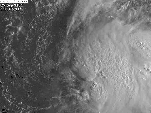
A 10z ship report shows winds TS force, Sustained south wind at 46mph. You can see it in the my GE image below in yellow ship mark. But it also looks like the center may becoming exposed in the last few visible images and from look at other ship and buoy reports:

0 likes
-
Ed Mahmoud
Re: ATL INVEST 93L: Discussion
One can see the LLC fairly well on IR loops, and it appears it is becoming more exposed, with convection moving further to the East and away from the LLC.
0 likes
-
deltadog03

- Professional-Met
- Posts: 3580
- Joined: Tue Jul 05, 2005 6:16 pm
- Location: Macon, GA
Re: ATL INVEST 93L: Discussion
WXMAN was talking about this yesterday, I believe it was yesterday, about how its about to hit some shear head on.
0 likes
-
HURAKAN

- Professional-Met
- Posts: 46084
- Age: 39
- Joined: Thu May 20, 2004 4:34 pm
- Location: Key West, FL
- Contact:
TROPICAL WEATHER DISCUSSION
NWS TPC/NATIONAL HURRICANE CENTER MIAMI FL
805 AM EDT THU SEP 25 2008
A BROAD AREA OF LOW PRESSURE IS ANALYZED AS A 1005 MB LOW IS
JUST TO THE NE OF THE TURKS AND CAICOS NEAR 22N69W MOVING
NORTHWARD NEAR 10 KT. THIS SYSTEM HAS BECOME BETTER ORGANIZED
DURING THE PAST SEVERAL HOURS...AND UPPER-LEVEL WINDS ARE
EXPECTED TO GRADUALLY BECOME MORE FAVORABLE FOR A TROPICAL
DEPRESSION TO DEVELOP DURING THE NEXT DAY OR SO. THIS SYSTEM IS
BEING SHEARED BY THE DEEP LAYERED TROUGH TO THE W WITH SCATTERED
MODERATE/STRONG CONVECTION FROM 20N-24N BETWEEN 65W-68W AND
SCATTERED SHOWERS/ISOLATED THUNDERSTORMS OVER THE SW ATLC FROM
18N-26N BETWEEN 61W-70W INCLUDING ISLANDS THE VIRGIN ISLANDS...
PUERTO RICO AND HISPANIOLA.
0 likes
-
Lowpressure

- S2K Supporter

- Posts: 2032
- Age: 59
- Joined: Sun Sep 14, 2003 9:17 am
- Location: Charlotte, North Carolina
Re:
HURAKAN wrote:Can anyone explain to me why this system is not TD 11 or TS Kyle?
Just a thought Luis. Does it matter in PR, insurance wise, whether a system is named or not?
0 likes
-
Lowpressure
- S2K Supporter
- Posts: 2032
- Age: 59
- Joined: Sun Sep 14, 2003 9:17 am
- Location: Charlotte, North Carolina
Re: Re:
Ed Mahmoud wrote:Lowpressure wrote:HURAKAN wrote:Can anyone explain to me why this system is not TD 11 or TS Kyle?
Just a thought Luis. Does it matter in PR, insurance wise, whether a system is named or not?
NHC answers to insurance company puppet-masters?
After the beat down with Katrina and now Ike, don't be too sure. You saw what just happened in the financial marketplace last week.
0 likes
Re:
HURAKAN wrote:Can anyone explain to me why this system is not TD 11 or TS Kyle?
I guess they are waiting for it to fall apart, poses little threat to land right now. If this were in 94L's current position, it probably would be upgraded last night.
0 likes
Who is online
Users browsing this forum: No registered users and 11 guests