
BEGIN
NHC
invest_al932008.invest
FSTDA
R
U
040
010
0000
200811030643
NONE
NOTIFY=ATRP
END
INVEST, AL, L, , , , , 93, 2008, DB, O, 2008110306, 9999999999, , , , , , METWATCH, , AL932008
AL, 93, 2008110206, , BEST, 0, 115N, 779W, 20, 1010, DB, 0, , 0, 0, 0, 0,
AL, 93, 2008110212, , BEST, 0, 116N, 784W, 20, 1010, DB, 0, , 0, 0, 0, 0,
AL, 93, 2008110218, , BEST, 0, 118N, 787W, 20, 1010, DB, 0, , 0, 0, 0, 0,
AL, 93, 2008110300, , BEST, 0, 115N, 793W, 20, 1010, DB, 0, , 0, 0, 0, 0,
AL, 93, 2008110306, , BEST, 0, 116N, 799W, 20, 1009, DB, 34, NEQ, 0, 0, 0, 0, 1011, 150, 60, 0, 0, L, 0, , 0, 0, INVEST, M,
ATL: PALOMA - Tropical Depression - Discussion
Moderator: S2k Moderators
-
TheEuropean

- Professional-Met

- Posts: 1797
- Age: 60
- Joined: Tue Sep 20, 2005 3:17 pm
- Location: Voerde, Germany
- Contact:
-
Matt-hurricanewatcher
Re: ATL: Invest 93L - Discussion
Looks weak to me. We will see if it can fire off some convection and even then I expect the nhc will wait until it makes it into the Atlantic before they upgrade if at all. I give this about as much since as the lord coming to my house tomarrow morning with a giant trout!
0 likes

Re: ATL: Invest 93L - Discussion
[quote="Matt-hurricanewatcher" I give this about as much since as the lord coming to my house tomarrow morning with a giant trout![/quote]
I have never ever in my way over half century of life heard this metaphor !...... Matt,I believe you got your point across
I have never ever in my way over half century of life heard this metaphor !...... Matt,I believe you got your point across
0 likes
-
Blown Away

- S2K Supporter

- Posts: 10253
- Joined: Wed May 26, 2004 6:17 am
Re: ATL: Invest 93L - Discussion
I agree Hurakan, looking much better this morning. I think we will see a TS out of this area.
0 likes
-
HURAKAN

- Professional-Met
- Posts: 46084
- Age: 39
- Joined: Thu May 20, 2004 4:34 pm
- Location: Key West, FL
- Contact:
Re: ATL: Invest 93L - Discussion
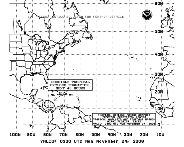
TROPICAL WEATHER OUTLOOK
NWS TPC/NATIONAL HURRICANE CENTER MIAMI FL
700 AM EST MON NOV 3 2008
FOR THE NORTH ATLANTIC...CARIBBEAN SEA AND THE GULF OF MEXICO...
DISORGANIZED CLOUDINESS...SHOWERS...AND THUNDERSTORMS ARE OCCURRING
OVER THE SOUTHWESTERN CARIBBEAN SEA IN ASSOCIATION WITH A BROAD AND
NEARLY STATIONARY LOW PRESSURE AREA. UPPER-LEVEL WINDS ARE
FAVORABLE FOR SOME DEVELOPMENT OF THIS SYSTEM OVER THE NEXT COUPLE
OF DAYS.
ELSEWHERE...TROPICAL CYCLONE FORMATION IS NOT EXPECTED DURING THE
NEXT 48 HOURS.
$$
FORECASTER BEVEN
0 likes
-
gatorcane

- S2K Supporter
- Posts: 23708
- Age: 48
- Joined: Sun Mar 13, 2005 3:54 pm
- Location: Boca Raton, FL
Here is a good link for viewing this area of disturbed weather. There is clear cyclonic turning in the SW Caribbean and a tropical depression may be in order in the next day or so:
http://metofis.rsmas.miami.edu/~dortt/s ... 1_loop.gif
http://metofis.rsmas.miami.edu/~dortt/s ... 1_loop.gif
0 likes


Re: ATL: Invest 93L - Discussion
Matt-hurricanewatcher wrote:even then I expect the nhc will wait until it makes it into the Atlantic before they upgrade if at all.
Why would they do that?
0 likes
-
Evil Jeremy

- S2K Supporter
- Posts: 5463
- Age: 32
- Joined: Mon Apr 10, 2006 2:10 pm
- Location: Los Angeles, CA
Re: ATL: Invest 93L - Discussion
The posts in this forum are NOT official forecast and should not be used as such. They are just the opinion of the poster and may or may not be backed by sound meteorological data. They are NOT endorsed by any professional institution or storm2k.org. For official information, please refer to the NHC and NWS products.
I give this about a 20% chance of this becoming anything. Whatever does come out of this would bring more rain to Cuba. A moderate TS at best. Should not be a problem for Florida, but things always change in the tropics.
0 likes
-
HURAKAN
- Professional-Met
- Posts: 46084
- Age: 39
- Joined: Thu May 20, 2004 4:34 pm
- Location: Key West, FL
- Contact:
Re: ATL: Invest 93L - Discussion
Disturbance 93L in southern Caribbean may develop later this week
Posted by: JeffMasters,
An area of disturbed weather (93L), associated with a broad area of low pressure that formed at the tail end of a stalled-out cold front, continues in the south-central Caribbean Sea. The disturbance has a strong potential to develop into a tropical storm by late this week. This morning's QuikSCAT pass missed 93L, but last night's QuikSCAT pass revealed an elongated circulation center near 11N 79W, about 300 miles north of the Panama Canal. Wind shear is a low to moderate 5-15 knots over the disturbance. Visible satellite images show that heavy thunderstorm activity has changed little in coverage or intensity over the past day in association with 93L, and the storm is quite disorganized at present. However, precipitable water imagery shows that the atmosphere has moistened considerably over the south-central Caribbean over the past day, and I expect a marked increase in heavy thunderstorm activity over the region by Tuesday.
The forecast
Wind shear is expected to remain in the moderate range, 10-20 knots, over the southern Caribbean during the remainder of the week. Water temperatures are warm, 29.5°C, and this warm water extends to great depth. These are favorable conditions for intensification, and both the GFDL and HWRF models predict 93L will become a hurricane. However, the SHIPS intensity model does not develop 93L at all.
Steering currents are weak, but a slow west-northwest to northwest motion of 93L is likely beginning on Tuesday, when an intensifying extratropical storm off the east coast of Florida should impart northwesterly steering currents over the southern Caribbean. Most of the models foresee that 93L will move to a point just offshore the Nicaragua-Honduras border by Thursday. At that time, a strong trough of low pressure will be approaching the U.S. East Coast. Most of the models predict that this trough will be strong enough to pull 93L northward towards western Cuba (GFDL and UKMET models), or even northeastwards, towards eastern Cuba and Jamaica (HWRF and ECMWF models). These two models foresee a possible threat to the Bahamas or South Florida late this week or early next week. The GFS model predicts the trough will not be strong enough to turn 93L northwards, and predicts a landfall in Nicaragua late this week. Since this is the outlier, I am discounting this solution, and predict that 93L will remain over water this week, becoming Tropical Storm Paloma Wednesday or Thursday. NHC is giving 93L a medium (20%-50% chance) of developing into a tropical storm by Wednesday morning. I give 93L a 40% chance of eventually becoming a hurricane.
Northeastern Nicaragua and northeastern Honduras are at risk of heavy rains from 93L beginning Tuesday. Total rainfall amounts of 4-8 inches are likely through Wednesday in these countries. Panama and Costa Rica will probably receive about 2-4 inches of rain through Wednesday. Heavy rains will likely move into the Cayman Islands on Wednesday.
I'll have an update Tuesday morning.
Jeff Masters
0 likes
-
Blown Away
- S2K Supporter
- Posts: 10253
- Joined: Wed May 26, 2004 6:17 am
Re:
gatorcane wrote:Jeff Masters seems to be entertaining the possibility of 93L becoming a TS or hurricane impacting South Florida (or coming very close)
Jeff changed his tune a little from Sunday's update and now has SFL/Bahamas as a possible scenerio.
0 likes
-
x-y-no

- Category 5

- Posts: 8359
- Age: 65
- Joined: Wed Aug 11, 2004 12:14 pm
- Location: Fort Lauderdale, FL
Re:
gatorcane wrote:Jeff Masters seems to be entertaining the possibility of 93L becoming a TS or hurricane impacting South Florida (or coming very close)
As things look now, I'm inclined to think any track will be southeast of us. But anytime something forms in that region late in the year we have to watch it.
0 likes


-
gatorcane
- S2K Supporter
- Posts: 23708
- Age: 48
- Joined: Sun Mar 13, 2005 3:54 pm
- Location: Boca Raton, FL
I'm surprised with the board's lack of intersest in 93L -- certainly seems on its way to becoming a depression and possibly Paloma this week. In fact it may even become a hurricane in the WCAR or NWCAR although I'll stay conservative and call for a tropical storm.

Last edited by gatorcane on Mon Nov 03, 2008 11:32 am, edited 2 times in total.
0 likes
-
MGC

- S2K Supporter
- Posts: 5941
- Joined: Sun Mar 23, 2003 9:05 pm
- Location: Pass Christian MS, or what is left.
Re: ATL: Invest 93L - Discussion
From the looks of it, 93L continues to slowly become better organized this morning. There is clearly a cyclonic spin quite evident on the visible and IR loops. Convection needs to become better concentrated though. As long as the disturbance can remain free of excessive shear I see no reason 93L will not continue to slowly organize. Chance of a TD forming are good...MGC
Of course the above is the opinion of MGC and not an official forecast.
Of course the above is the opinion of MGC and not an official forecast.
0 likes
Who is online
Users browsing this forum: No registered users and 37 guests