Strong winds still...got pretty rough this morning at Clearwater
Beach- the station there had 35 mph sustained with 41 mph
wind gusts...
http://www.wunderground.com/weatherstat ... ?ID=MCWBF1
Winds still 26 mph sustained with gusts to 33 mph
Florida Weather
Moderator: S2k Moderators
Forum rules

The posts in this forum are NOT official forecast and should not be used as such. They are just the opinion of the poster and may or may not be backed by sound meteorological data. They are NOT endorsed by any professional institution or STORM2K.
-
Tampa Bay Hurricane

- Category 5

- Posts: 5597
- Age: 38
- Joined: Fri Jul 22, 2005 7:54 pm
- Location: St. Petersburg, FL
-
HURRICANELONNY
- Category 5
- Posts: 1390
- Joined: Wed May 07, 2003 6:48 am
- Location: HOLLYWOOD.FL
Re: Florida Weather Thread: Cooler/Dryer air on the way.
49.5 THIS MORNING IN HOLLYWOOD. I THINK THAT'S IT FOR THE COLD THIS WINTER. HECK DAYLIGHT SAVINGS NEXT SUNDAY. 
0 likes
-
Evil Jeremy

- S2K Supporter

- Posts: 5463
- Age: 32
- Joined: Mon Apr 10, 2006 2:10 pm
- Location: Los Angeles, CA
Re: Florida Weather Thread: Cooler/Dryer air on the way.
It is currently 49 degrees where I am right now, though with those wind chills, it feels colder. Seems like it will be the same tomorrow.
0 likes
Re: Florida Weather Thread: Cooler/Dryer air on the way.
52* low last night. Cold front plunging today. Shade north side of house 60* Shade on south sunny side of house 63* Coldest low tonight.
Quick plunger deep trough then warm up wednesday.
Quick plunger deep trough then warm up wednesday.
0 likes
Re: Florida Weather Thread: Cooler/Dryer air on the way.
No rain in the forecast...temps warming up nicely by the end of the week as ridge sets up
AREA FORECAST DISCUSSION
NATIONAL WEATHER SERVICE MIAMI FL
231 PM EST MON MAR 2 2009
.DISCUSSION...
IT WILL BE MOSTLY SUNNY THE NEXT FEW DAYS AND
GENERALLY DRY. THE ONLY SLIGHT CHANCE FOR A SHOWER OR TWO WILL COME
WEDNESDAY AS A WEAK BACKDOOR/REINFORCING COLD FRONT MOVES SOUTH
ACROSS THE AREA WITH A SLIGHT INCREASE IN MOISTURE/CLOUDS. BEHIND THIS FRONT A
DEEP-LAYER SFC-500MB RIDGE WILL BUILD ACROSS THE FL PENINSULA
FRIDAY INTO NEXT WEEKEND KEEPING TRANQUIL BUT WARMER WEATHER
CONDITIONS IN PLACE.
0 likes

-
JonathanBelles
- Professional-Met

- Posts: 11430
- Age: 35
- Joined: Sat Dec 24, 2005 9:00 pm
- Location: School: Florida State University (Tallahassee, FL) Home: St. Petersburg, Florida
- Contact:
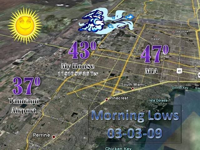
Looking at the local obs both here an outside Tampa. Both seem lower than forecast. Upper 30's in upper St. Pete; forecasted mid 40's. Taking in the microclimate, it still seems lower. I'll run out in a bit to get a look at my thermometer. I think that a freeze warning or some sort of advisory could have been warranted for interior Hillsborough Co.
0 likes
-
JonathanBelles
- Professional-Met
- Posts: 11430
- Age: 35
- Joined: Sat Dec 24, 2005 9:00 pm
- Location: School: Florida State University (Tallahassee, FL) Home: St. Petersburg, Florida
- Contact:
-
HURRICANELONNY
- Category 5
- Posts: 1390
- Joined: Wed May 07, 2003 6:48 am
- Location: HOLLYWOOD.FL

Re: Florida Weather Thread: Cooler/Dryer air on the way.
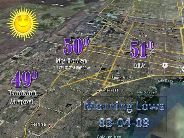
Moderation slowly becomes today and takes full effect by the end of the week. Forecast lows tonight are 54 in both Miami and Fort Lauderdale and 52 in West Palm. Add about 5-6 deg to those for Wednesday night's forecast lows.
AREA FORECAST DISCUSSION...UPDATED
NATIONAL WEATHER SERVICE MIAMI FL
819 AM EST TUE MAR 3 2009
DISCUSSION...AS THE COLD FRONT MOVES FURTHER EAST, STRONG HIGH
PRESSURE OVER WISCONSIN WILL MOVE SOUTHEAST AND WON`T EXIT THE
CAROLINA COAST UNTIL MAYBE AS LATE AS WEDNESDAY NIGHT. BUT TODAY
AND TONIGHT A TROUGH OF LOW PRESSURE WILL MOVE SOUTHWARD OVER THE
ATLANTIC WATERS AND POSSIBLY PRODUCE A FEW LOW TOPPED SHOWERS OVER
THE SOUTHEAST ATLANTIC WATERS AND COASTAL AREAS TONIGHT. WINDS
WILL VEER TO THE NORTHEAST AND INCREASE A BIT WITH THIS TROUGH
AND AS THE HIGH MOVES OFF THE CAROLINA COAST, THE LOW LEVEL WINDS
TURN EAST AND SPEEDS BECOME RELATIVELY LIGHT AND MODERATION OF THE
AIRMASS WILL BEGIN WITH ALL AREAS GETTING IN THE 70`S.
BY THE END OF THE WEEK AND THE WEEKEND, THE SURFACE HIGH WILL MOVE SOUTH AND
PARK ITSELF OVER THE ATLANTIC EAST OF CENTRAL FLORIDA AS A MID
LEVEL HIGH PRESSURE BUILDS OVER THE GULF OF MEXICO AND FLORIDA.
BY THIS WEEKEND, TEMPERATURES WILL GET INTO THE LOWER TO MID 80S
WITH THE WARMEST AREAS OVER THE INTERIOR. OUTSIDE OF THE SLIGHT
CHANCE OF RAIN TONIGHT, EXPECT NO RAINFALL THROUGH EARLY NEXT
WEEK.
0 likes
Re: Florida Weather Thread: Cooler/Dryer air on the way.
It's official....driest winter on record in parts of south florida..including Miami and Fort Lauderdale..areas seen 8-20% of normal precip since November 1. Excellent info to get an understanding of just how abnormal this 'dry' season has been...unchartered territory as far as drought and fire threat.
PUBLIC INFORMATION STATEMENT
NATIONAL WEATHER SERVICE MIAMI FL
1000 AM EST MON MAR 2 2009
...DRIEST WINTER ON RECORD OVER PARTS OF SOUTH FLORIDA...
...FIRE DANGER EXTREMELY HIGH...
February continued the extended period of extreme dryness across most of south Florida as the area remained stuck in a very dry weather pattern. As was the case in January, several cold fronts passed through the area last month. However, atmospheric conditions were not conducive for significant rainfall in advance of these weather systems. As a result, February 2009 went on record as one of the driest Februaries on record at several south Florida locations. These include West Palm Beach which for the second month in a row recorded a record dry month, Miami International Airport which recorded its fifth driest February, Miami Beach which recorded its fourth driest February and Naples which recorded its seventh driest February.
The three-month rainfall totals including the months of December 2008 and January and February 2009 ranked as the lowest on record at several locations. Miami and Fort Lauderdale recorded their driest December- February on record, with West Palm Beach, Naples and Miami Beach having their second driest all time winter period.
Going back to November 1, 2008, the eastern half of south Florida has received less than 25 percent of the average rainfall for this period, with most western areas at 25 to 40 percent of normal. At Miami and Naples, the percent of normal rainfall since November 1 is at 18 percent, at West Palm Beach it is 20 percent, at Miami Beach it is 15 percent and at Fort Lauderdale International it is an incredibly low 8 percent. Moore Haven has a slightly higher percentage of 36 percent compared to normal since November.
The very dry conditions have led to extremely high fire danger over all of south Florida. The normal start of the south Florida wildfire season is in March, but the extremely high values currently being observed are well ahead of schedule and have already led to a significant number of small wildfires over the region. The combination of these factors means that eastern metro areas of south Florida are under severe drought conditions, with moderate drought conditions elsewhere except in the Naples area where abnormally dry conditions are noted.
The outlook for March through May is for continued drier than normal conditions as La Niña is expected to persist through this period. These expected dry conditions will further exacerbate the wildfire threat over the region, and fire danger levels are likely to remain extremely high during the next 3 months. During the very dry winter and spring seasons of 1985 and 1989, a combined total of over a million acres were burned as a result of wildfires. With a similar lack of rainfall expected this spring, wildfires could once again become a big concern for all South Floridians. All persons are strongly urged to heed all bans on burning and take measures to prevent wildfires during the next few months.
For further information on this developing situation, please visit the National Weather Service Miami website at http://WWW.WEATHER.GOV/MIAMI.
$$
MOLLEDA
0 likes
Re: Florida Weather Thread: Cooler/Dryer air on the way.
48.4* low last night.
Only 64* right now.
74* forecast tomorrow.
Only 64* right now.
74* forecast tomorrow.
0 likes
-
HURRICANELONNY
- Category 5
- Posts: 1390
- Joined: Wed May 07, 2003 6:48 am
- Location: HOLLYWOOD.FL
Re: Florida Weather Thread: Cooler/Dryer air on the way.
Front lasted longer than forecast. 46.9* low last night. Only upper 60's today.
March sun has a nice bite to it even in cool air.
March sun has a nice bite to it even in cool air.
0 likes
-
gatorcane

- S2K Supporter
- Posts: 23708
- Age: 48
- Joined: Sun Mar 13, 2005 3:54 pm
- Location: Boca Raton, FL
Re: Florida Weather Thread: Cooler/Dryer air on the way.
Rain showers are forming along coastal Palm Beach County heading WSW into inland Palm Beach in the wake of a trough that is moving through. This should certainly help alleviate the fire danger, at least in Palm Beach County.
0 likes
Re: Florida Weather Thread: Cooler/Dryer air on the way.
Not much in the way of drought-busting rain to take place in the next week....including the scattered showers some areas are seeing today in palm beach county
AFDMFL
AREA FORECAST DISCUSSION
NATIONAL WEATHER SERVICE MIAMI FL
916 AM EST WED MAR 4 2009
.UPDATE...
WEAK SFC TROUGH IS MOVING INTO PALM BEACH COUNTY/LAKE OKEECHOBEE
AREA THIS MORNING. NERLY WIND SURGE EVIDENT BEHIND IT AND THIS IS
COMBINING WITH LAND BREEZE TO PRODUCE GOOD CONVERGENCE AND LOTS OF
CLOUDS THIS MORNING ACROSS PALM BEACH COUNTY. AS THE DISTURBANCE
CONTINUES SOUTH A FEW LIGHT SHOWERS ARE POSSIBLE, ALONG WITH AN
INCREASE IN CLOUDS FURTHER DOWN THE COAST. HAVE UPDATED THE
FORECAST TO REFLECT THESE EXPECTATIONS, AND HAVE SKIES BECOMING
MOSTLY CLOUDY THIS AFTERNOON OVER THE REMAINDER OF THE EAST COAST
METRO AREAS AS LAND BREEZE WILL GRADUALLY GIVE WAY.
OUTSIDE OF THIS SLIGHT CHANCE OF SHOWERS,
DON`T EXPECT ANY RAINFALL TROUGH EARLY NEXT WEEK.
TEMPERATURES WILL WARM ABOVE THE NORMAL VALUES BY THIS WEEKEND.
CHANCE OF RIP CURRENTS WILL BE ELEVATED FOR THE NEXT SEVERAL DAYS
OVER THE ATLANTIC BEACHES.
0 likes
Re: Florida Weather Thread: Cooler/Dryer air on the way.
Moderation continues statewide..as of noon today, temps in the 70's from I-4 corridor south.

0 likes
-
Tampa_God

- Category 1

- Posts: 333
- Age: 35
- Joined: Wed May 31, 2006 7:27 pm
- Location: New Port Richey/Trinity, FL
Re: Florida Weather Thread: Cooler/Dryer air on the way.
I never knew how much difference there is between seeing or hearing of a brushfire on television and actually seeing one not even 15 feet from you. I did some snooping when I heard some firetrucks and when I got on to one of the main roads, I saw smoke. So I was guessing it was a house fire becuase I knew there were houses back where it was. But when I turned around the corner on a side street, it hit me that it was a brushfire right next to a residential retirement neighborhood. I would had taken pics, but 1) didn't want to get in the way of the firefighters 2) I was getting strange looks from some of the residents and 3) I didn't have my camera. But its quite different seeing it from that perspective. and it was only yards away from the back of some people homes too, so you felt some remorse hoping that the fire didn't catch their homes on fire.
0 likes
Return to “USA & Caribbean Weather”
Who is online
Users browsing this forum: No registered users and 29 guests