Florida Weather
Moderator: S2k Moderators
Forum rules

The posts in this forum are NOT official forecast and should not be used as such. They are just the opinion of the poster and may or may not be backed by sound meteorological data. They are NOT endorsed by any professional institution or STORM2K.
Re:
Be interesting to see update later today on KBDI index....east coast areas of south florida will definitely see some localized areas of significant improvement....but i don't anticipate the 700 readings to be anyone near gone statewide..some of the areas with highest readings have had from 0 precip to a quarter inch in the last 24 hours....matching the radar precip estimates map to kbdi shows that inland counties fared the worst with rainfall.

HURAKAN wrote:
0 likes

-
Tampa Bay Hurricane

- Category 5

- Posts: 5597
- Age: 38
- Joined: Fri Jul 22, 2005 7:54 pm
- Location: St. Petersburg, FL
Scattered cumulus clouds are building into the sky inland over
southern hillsborough county south of tampa- I expect some storms
later- there are already isolated showers south of Orlando
moving west into central florida with the east coast sea breeze, it should
collide with the west coast sea breeze in a couple of hours- a strong
east wind will keep the west coast sea breeze close to the west
coast, so the best chance of rain will be near the coast
along that collision boundary by about 5 PM. I do NOT expect
widespread rain, but I do think there will be some isolated
moderate rain showers later.
Some convergence between the east wind and a weak
seabreeze has resulted in a moderate shower at the mouth
of tampa bay, seen moving towards the skyway bridge:
http://radar.weather.gov/ridge/radar.ph ... 1&loop=yes
0 likes
Re: Florida Weather Thread: Cold front brings needed rain
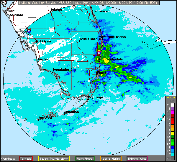
KBDI fell below 700 in Miami-Dade, Broward, and a few other counties as well....and some further decreases may take place with tomorrow's update for rain that falls between now and then....but the numbers show that one rain event...esp what was in reality one pretty localized heavy rain event (eastern palm beach and northeast broward getting the most)...won't raise Lake O by 2 or 3' or cancel out the 1 foot+ rainfall deficits going back to November 2008.

The detailed map shows that the effects of the rain were very beneficial....but localized to mainly the eastern metro areas.
Counties with highest KBDI with change since yesterday in ( ):
Hendry 740 (+2)
DeSoto 731 (-4)
Highlands 731 (-4)
Glades 720 (-12)
Palm Beach 719 (-8)
Sumter 719 (+2)
Lake 707 (+3)
Okeechobee 705 (+0)
Collier 702 (+1)
Martin 697 (-19)
Hardee 689 (-13)
Miami-Dade 689 (-16)
Hernando 687 (+2)
Broward 686 (-23)
Flagler 686 (+2)
St. Lucie 681 (-1)
http://flame.fl-dof.com/fire_weather/KB ... eport.html
This rain event absolutely surpassed expectations in the metro se fl....but the rest of the state hasn't been nearly as lucky. By late week, all areas will begin to dry out once again.
Last edited by jinftl on Wed Mar 18, 2009 3:28 pm, edited 1 time in total.
0 likes
-
JonathanBelles
- Professional-Met

- Posts: 11430
- Age: 35
- Joined: Sat Dec 24, 2005 9:00 pm
- Location: School: Florida State University (Tallahassee, FL) Home: St. Petersburg, Florida
- Contact:
-
HURAKAN

- Professional-Met
- Posts: 46084
- Age: 39
- Joined: Thu May 20, 2004 4:34 pm
- Location: Key West, FL
- Contact:
Re:
fact789 wrote:The new meteorology station on my college campus was reporting 86 degrees just before I left at 4! wow!
I have a problem with FIU's weather station. They have it in the top of Primera Casa, a 5-story building.
0 likes
-
JonathanBelles
- Professional-Met
- Posts: 11430
- Age: 35
- Joined: Sat Dec 24, 2005 9:00 pm
- Location: School: Florida State University (Tallahassee, FL) Home: St. Petersburg, Florida
- Contact:
Re: Re:
HURAKAN wrote:fact789 wrote:The new meteorology station on my college campus was reporting 86 degrees just before I left at 4! wow!
I have a problem with FIU's weather station. They have it in the top of Primera Casa, a 5-story building.
Ours is (or at least from what I was told) at 6 feet in the shade in the Quad.
0 likes
-
Tampa Bay Hurricane
- Category 5
- Posts: 5597
- Age: 38
- Joined: Fri Jul 22, 2005 7:54 pm
- Location: St. Petersburg, FL
Getting hot outside with the east wind stopping the sea breeze- but there are
some thicker darker clouds forming over central Pinellas- first seabreeze
dark clouds of the season- same thing near the skyway over the mouth of the
Bay, an area of dark clouds- maybe some thunderstorms? In any case,
the clouds have began converging interior Pinellas and mouth of the Bay,
at quarter to 5, so maybe we can get some storms to form!
Update: First rain of the season near Pinellas Park!!! (unfortunately it missed
me):
http://radar.weather.gov/ridge/radar.ph ... 1&loop=yes
You can see the west coast seabreeze move inland just barely and collide with an
area of clouds forming a moderate shower (very tiny shower) over central Pinellas...
0 likes
-
Tampa Bay Hurricane
- Category 5
- Posts: 5597
- Age: 38
- Joined: Fri Jul 22, 2005 7:54 pm
- Location: St. Petersburg, FL
-
Tampa Bay Hurricane
- Category 5
- Posts: 5597
- Age: 38
- Joined: Fri Jul 22, 2005 7:54 pm
- Location: St. Petersburg, FL
-
gatorcane

- S2K Supporter

- Posts: 23708
- Age: 48
- Joined: Sun Mar 13, 2005 3:54 pm
- Location: Boca Raton, FL
Re: Florida Weather Thread: Cold front brings needed rain
heavy rains pushing into interior Palm Beach County now and into Lake O.
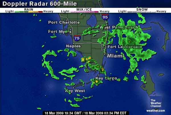
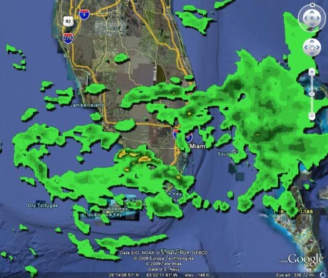
Mesoscale convergence now has moved from Broward/S. Palm Beach to Central Palm Beach County and West Palm metro areas as northern Palm Beach County has not seen the copious amounts of rain seen further south. But now looks like the rain totals are increasing across much of the CWA.
At this rate, this drought is going to be long gone. Fire threat is moving to low. True rainy season begins in only about 2 months.
West Central and SW FL remain dry. The drought will continue for all areas of FL except SE FL - Palm Beach, Broward, and Miami-Dade.
0 likes
-
Tampa Bay Hurricane
- Category 5
- Posts: 5597
- Age: 38
- Joined: Fri Jul 22, 2005 7:54 pm
- Location: St. Petersburg, FL
Re: Florida Weather Thread: Cold front brings needed rain
I truly do hope this is exactly as you say, the beginning of the end of the drought in se fl....surely a dent in it has been made. I will be the first to write in all caps 'drought cancel' but we do have a long way to go if you measure catching up on rain deficits as an indicator of the drought being over. What we really need is 4 or 5 rain events in a row like this...and that may happen come may or june....but today's rain alone hasn't even put the official reporting stations at normal totals for month-to-date for March. But it is a blessing for sure....no debating that.
While rain continues to fall in parts of the area, and some more impressive totals may take place in the next 24 hours, the forecast after that is for dry conditons.
Miami
Total Rain today: 1.13"
Total Month to Date: 1.14" (-0.30")
Total since 1/1/09: 1.60" (-3.79")
Total since 11/1/08: 2.85" (-8.15")
Fort Lauderdale
Total Rain today: 1.02"
Total Month to Date: 1.05" (-0.52")
Total since 1/1/09: 1.31" (-5.90")
Total since 11/1/08: 2.03" (-12.40")
West Palm Beach
Total Rain today: 0.81"
Total Month to Date: 0.89" (-1.17")
Total since 1/1/09: 1.14" (-7.22")
Total since 11/1/08: 3.79" (-13.26")
Naples
Total Rain today: 0.01"
Total Month to Date: 0.01" (-0.30")
Total since 1/1/09: 0.48" (-4.97")
Total since 11/1/08: 1.41" (-7.56")
The other parts of the state are in no way even close to being out of the woods for drought...and the fire threat continues to grow. As we have seen in past years, fire season can continue into the summer esp in areas north of Lake O.
Looking at the total rainfall since yesterday, this has been a bonanza event from Boynton Beach/Lake Worth south through north part of Fort Lauderdale (north of I-595 for those who know the local roads) and their western suburbs....pretty meager elsewhere...hopefully we can add an inch or 2 into the everglades and Lake O before things dry out.
gatorcane wrote:heavy rains pushing into interior Palm Beach County now and into Lake O.
Mesoscale convergence now has moved from Broward/S. Palm Beach to Central Palm Beach County and West Palm metro areas as northern Palm Beach County has not seen the copious amounts of rain seen further south. But now looks like the rain totals are increasing across much of the CWA.
At this rate, this drought is going to be long gone. Fire threat is moving to low. True rainy season begins in only about 2 months.
West Central and SW FL remain dry. The drought will continue for all areas of FL except SE FL - Palm Beach, Broward, and Miami-Dade.
0 likes
-
HURRICANELONNY
- Category 5
- Posts: 1390
- Joined: Wed May 07, 2003 6:48 am
- Location: HOLLYWOOD.FL
-
gatorcane
- S2K Supporter
- Posts: 23708
- Age: 48
- Joined: Sun Mar 13, 2005 3:54 pm
- Location: Boca Raton, FL
Re: Florida Weather Thread: Cold front brings needed rain
seems that this rain only wants to visit the "tropical" areas of FL (Southern Florida). Once you get north of a line from about Ft. Myers to Hobe Sound/Port St. Lucie, the skies are actually very clear and conditions dry.
0 likes
Return to “USA & Caribbean Weather”
Who is online
Users browsing this forum: No registered users and 36 guests