Florida Weather

U.S. & Caribbean Weather Discussions and Severe Weather Events

Moderator: S2k Moderators

Forum rules

The posts in this forum are NOT official forecast and should not be used as such. They are just the opinion of the poster and may or may not be backed by sound meteorological data. They are NOT endorsed by any professional institution or STORM2K.

Help Support Storm2K
Message
Author
jinftl
Category 5
Category 5
Posts: 4312
Joined: Tue Aug 31, 2004 4:47 pm
Location: fort lauderdale, fl

Re: Florida Weather Thread: SLGT Risk/TOR Watch in the Panhandle

#4241 Postby jinftl » Thu Apr 02, 2009 7:51 pm

Hot and generally rainfree acoss the peninsula today.

Preliminary High Temps:
BROOKSVILLE 86
DAYTONA BEACH 87
FORT LAUDERDALE INTL 89
FORT MYERS 85
FORT PIERCE 90
GAINESVILLE 84
KEY WEST 84
MELBOURNE 89
MIAMI 89
NAPLES 85
ORLANDO INTL 91
ST. PETERSBURG/CLEARWATER 86
TAMPA 83
VERO BEACH 90
WINTER HAVEN 90
WEST PALM BEACH 89

Meanwhile, the panhandle saw heavy rain.

Total rain during last 24 hours:
APALACHICOLA 1.99"
DESTIN 3.08"
MARIANA 5.03"
PANAMA CITY 5.42"
PENSACOLA 1.59"
TALLAHASSEE 4.21"

:sun: :sun: :sun:
What's on tap for Friday?

Panhandle dries out, central areas see scattered storms, south florida nears record highs again.

STATE FORECAST FOR FLORIDA
NATIONAL WEATHER SERVICE MIAMI FL
600 PM EDT THU APR 2 2009

.FRIDAY...PARTLY CLOUDY...EXCEPT MOSTLY SUNNY PANHANDLE AND MOSTLY
CLOUDY SOUTH CENTRAL. CHANCE OF SHOWERS AND THUNDERSTORMS CENTRAL
AND SOUTH CENTRAL. BREEZY SOUTH CENTRAL THROUGH KEYS. HIGHS IN THE
70S PANHANDLE...AROUND 80 NORTHEAST...CENTRAL AND KEYS...AND MID TO
UPPER 80S SOUTH...EXCEPT AROUND 90 SOUTHEAST.
.
0 likes   

JonathanBelles
Professional-Met
Professional-Met
Posts: 11430
Age: 35
Joined: Sat Dec 24, 2005 9:00 pm
Location: School: Florida State University (Tallahassee, FL) Home: St. Petersburg, Florida
Contact:

#4242 Postby JonathanBelles » Thu Apr 02, 2009 9:27 pm

The later the front gets to you in the FL Peninsula, the worse it will be. TOR issued for NFL, and it may be expected in SFL tomorrow.
0 likes   

User avatar
gatorcane
S2K Supporter
S2K Supporter
Posts: 23703
Age: 47
Joined: Sun Mar 13, 2005 3:54 pm
Location: Boca Raton, FL

Re:

#4243 Postby gatorcane » Thu Apr 02, 2009 9:34 pm

fact789 wrote:The later the front gets to you in the FL Peninsula, the worse it will be. TOR issued for NFL, and it may be expected in SFL tomorrow.


Not likely models are trending back on POPS and shunt energy North and East away from SFL. Tomorrow will feel like August with S to SW winds inland with winds veering to SE near the coast where it will be a good 5-7 degrees cooler. Expect mid 90s far western Broward and Miami-Dade with lower to mid 90s western Palm Beach County.
0 likes   

JonathanBelles
Professional-Met
Professional-Met
Posts: 11430
Age: 35
Joined: Sat Dec 24, 2005 9:00 pm
Location: School: Florida State University (Tallahassee, FL) Home: St. Petersburg, Florida
Contact:

#4244 Postby JonathanBelles » Thu Apr 02, 2009 9:38 pm

WITH LLJ EXPECTED TO INCREASE MARKEDLY AFTER 06Z IT APPEARS
WARM ADVECTION WILL BE THE PRIMARY DRIVING MECHANISM FOR POTENTIAL
SUPERCELL DEVELOPMENT. FORECAST SOUNDINGS ARE QUITE IMPRESSIVE
TOWARD SUNRISE AND IF SUFFICIENT BUOYANCY CAN SPREAD INLAND THEN
TORNADO THREAT WILL INCREASE SHARPLY WITH ANY SFC-BASED ACTIVITY.

From SPC Day 1
0 likes   

psyclone
S2K Supporter
S2K Supporter
Posts: 4802
Joined: Wed Aug 24, 2005 9:04 pm
Location: palm harbor fl

Re:

#4245 Postby psyclone » Thu Apr 02, 2009 10:00 pm

fact789 wrote:WITH LLJ EXPECTED TO INCREASE MARKEDLY AFTER 06Z IT APPEARS
WARM ADVECTION WILL BE THE PRIMARY DRIVING MECHANISM FOR POTENTIAL
SUPERCELL DEVELOPMENT. FORECAST SOUNDINGS ARE QUITE IMPRESSIVE
TOWARD SUNRISE AND IF SUFFICIENT BUOYANCY CAN SPREAD INLAND THEN
TORNADO THREAT WILL INCREASE SHARPLY WITH ANY SFC-BASED ACTIVITY.

From SPC Day 1

that is referring to convective potential in eastern NC, not Florida. I thnink peninsular Florida will mostly hear...crickets as upper support races away, like usual for this time of year.
0 likes   

jinftl
Category 5
Category 5
Posts: 4312
Joined: Tue Aug 31, 2004 4:47 pm
Location: fort lauderdale, fl

Re:

#4246 Postby jinftl » Fri Apr 03, 2009 12:55 am

SPC reference is from section on North Carolina (NC).
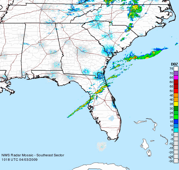
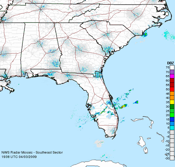
http://www.spc.noaa.gov/products/outlook/day1otlk.html


As with the last front on sunday, most of the energy will scoot of to the north and east of south florida. Only 20% rain chance friday through saturday.

Heat...not storms...will be the big story in south florida tomorrow...record temps in the low to mid 90's now forecast!

AREA FORECAST DISCUSSION...UPDATED
NATIONAL WEATHER SERVICE MIAMI FL
904 PM EDT THU APR 2 2009

.UPDATE...
RIDGE OF HIGH PRESSURE OVER THE WESTERN ATLANTIC WATERS CONTINUES
TO EXTEND WEST INTO SOUTH FLORIDA THIS EVENING. THE RIDGE WILL
BREAK DOWN LATE TONIGHT ALLOWING FOR A COLD FRONT OVER THE
CENTRAL GULF COAST STATES TO MOVE EAST TOWARDS SOUTH FLORIDA ON
FRIDAY. THIS WILL ALLOW FOR THE WINDS OVER THE AREA TO SWING FROM
A SOUTHERLY DIRECTION TONIGHT TO A SOUTHWEST DIRECTION ON FRIDAY.
SO HAVE REMOVE THE POPS FOR ALL OF THE CWA TONIGHT.

THE MID TO UPPER LEVEL ENERGY THAT IS OCCURRING OVER NORTH FLORIDA
THIS EVENING WILL ALSO CONTINUE TO MOVE NORTHEAST OVERNIGHT INTO
FRIDAY AND AWAY FROM SOUTH FLORIDA
. THE LATEST SHORT RANGE MODELS
HAVE ALSO DECREASE THE POPS OVER THE CWA A LITTLE BIT FOR FRIDAY.
SO HAVE LOWER THE POPS A LITTLE BIT OVER MOST OF THE CWA FOR
FRIDAY...AND REDUCED THE THUNDER WORDING TO SLIGHT CHANCE FROM
CHANCE.


THE OTHER CHANGE TO THE FORECAST IS TO MENTION NEAR RECORD HIGHS
FOR THE EAST COAST METRO AREAS FOR FRIDAY...AS TEMPS WILL BE IN
THE LOWER TO MID 90S.


NWS Forecast for: Miami FL
Issued by: National Weather Service Miami - South Florida
Last Update: 12:53 am EDT Apr 3, 2009
--------------------------------------------------------------------------------
Friday: A slight chance of showers, with thunderstorms also possible after 2pm. Partly cloudy, with a high near 92. Chance of precipitation is 20%.
Friday Night: A slight chance of showers before 2am. Patchy fog after 2am. Otherwise, partly cloudy, with a low around 72. Chance of precipitation is 20%.
Saturday: A 20 percent chance of showers after 2pm. Partly cloudy, with a high near 85.
Saturday Night: Partly cloudy, with a low around 70.
Sunday: Mostly sunny, with a high near 87.


fact789 wrote:The later the front gets to you in the FL Peninsula, the worse it will be. TOR issued for NFL, and it may be expected in SFL tomorrow.
0 likes   

User avatar
dizzyfish
S2K Supporter
S2K Supporter
Posts: 1520
Joined: Fri Sep 16, 2005 7:56 am
Location: New Port Richey, FL

Re: Florida Weather Thread: SLGT Risk/TOR Watch in NFL

#4247 Postby dizzyfish » Fri Apr 03, 2009 5:13 am

TORNADO WARNING
FLC035-107-109-031045-
/O.NEW.KJAX.TO.W.0009.090403T0956Z-090403T1045Z/

BULLETIN - EAS ACTIVATION REQUESTED
TORNADO WARNING
NATIONAL WEATHER SERVICE JACKSONVILLE FL
556 AM EDT FRI APR 3 2009

THE NATIONAL WEATHER SERVICE IN JACKSONVILLE HAS ISSUED A

* TORNADO WARNING FOR...
EASTERN PUTNAM COUNTY IN NORTHEAST FLORIDA
NORTHERN FLAGLER COUNTY IN NORTHEAST FLORIDA
SOUTHEASTERN ST. JOHNS COUNTY IN NORTHEAST FLORIDA

* UNTIL 645 AM EDT

* AT 557 AM EDT...NATIONAL WEATHER SERVICE DOPPLER RADAR INDICATED A
SEVERE THUNDERSTORM CAPABLE OF PRODUCING A TORNADO NEAR POMONA
PARK...MOVING EAST AT 45 MPH.

* OTHER LOCATIONS IN THE WARNING INCLUDE BUT ARE NOT LIMITED TO
ANDALUSIA...PALM COAST AND CRESCENT BEACH.
0 likes   

User avatar
HURAKAN
Professional-Met
Professional-Met
Posts: 46086
Age: 38
Joined: Thu May 20, 2004 4:34 pm
Location: Key West, FL
Contact:

#4248 Postby HURAKAN » Fri Apr 03, 2009 6:35 am

Image

Lets see if the heat expected today, plus the cold front can produce some showers here in south Florida.
0 likes   

User avatar
HURAKAN
Professional-Met
Professional-Met
Posts: 46086
Age: 38
Joined: Thu May 20, 2004 4:34 pm
Location: Key West, FL
Contact:

#4249 Postby HURAKAN » Fri Apr 03, 2009 7:41 am

After a very dry first half of March (0.02 inches of rain), the month rebounded and finished with 2.02 inches of rain in my house, compared to 2.62 last year.
0 likes   

User avatar
Tampa Bay Hurricane
Category 5
Category 5
Posts: 5598
Age: 37
Joined: Fri Jul 22, 2005 7:54 pm
Location: St. Petersburg, FL

Re: Florida Weather Thread: SLGT Risk/TOR Watch in NFL

#4250 Postby Tampa Bay Hurricane » Fri Apr 03, 2009 12:11 pm

It rained this morning and briefly the rain was heavy
0 likes   

User avatar
HURAKAN
Professional-Met
Professional-Met
Posts: 46086
Age: 38
Joined: Thu May 20, 2004 4:34 pm
Location: Key West, FL
Contact:

#4251 Postby HURAKAN » Fri Apr 03, 2009 3:59 pm

Image

Poof!
0 likes   

User avatar
Tampa Bay Hurricane
Category 5
Category 5
Posts: 5598
Age: 37
Joined: Fri Jul 22, 2005 7:54 pm
Location: St. Petersburg, FL

#4252 Postby Tampa Bay Hurricane » Fri Apr 03, 2009 8:53 pm

I think that Florida may have a significant wind event Monday...the temperatures
will drop 30 degrees from the low 90s Sunday to the low 60s Tuesday for
highs...right now NWS is forecasting 30 mph wind gusts. I expect
that forecast to be upgraded substantially. With the tempearture difference...
some coastal areas of Florida may have sustained 25-40 mph winds with
gusts to 50 mph easily. This is NOT OFFICIAL, but it is my experience
that whenever you have a front bring such a magnitude of temperature
difference...there is a lot of wind with it. Furthermore, any storms that
form Monday will likely tap into the extremely fast jet and could
produce damaging winds- I do not expect widespread severe weather- but
isolated stronger storms will have an impact.

My personal thought is that this temperature gradient may be enough
to bring tropical storm force winds to coastal areas.
0 likes   

jinftl
Category 5
Category 5
Posts: 4312
Joined: Tue Aug 31, 2004 4:47 pm
Location: fort lauderdale, fl

Re: Florida Weather Thread: SLGT Risk/TOR Watch in NFL

#4253 Postby jinftl » Fri Apr 03, 2009 10:07 pm

Florida is Florida...the weather is the same all over. Right?

This forecast says it all...literally!

STATE FORECAST FOR FLORIDA
NATIONAL WEATHER SERVICE MIAMI FL
544 PM EDT FRI APR 3 2009

.TONIGHT...MOSTLY CLEAR NORTH. PARTLY CLOUDY...THEN CLEARING
CENTRAL. PARTLY CLOUDY ELSEWHERE. A SLIGHT CHANCE OF SHOWERS SOUTH
AND KEYS...MAINLY IN THE EVENING. PATCHY LATE NIGHT FOG MAINLAND
SOUTH. LOWS IN THE UPPER 40S TO MID 50S NORTH....UPPER 50S TO LOWER
60S CENTRAL...IN THE 60S SOUTH
...EXCEPT 70S SOUTHEAST AND KEYS.

.SATURDAY...MOSTLY SUNNY NORTH TO PARTLY CLOUDY SOUTH. SLIGHT CHANCE
OF SHOWERS IN THE KEYS. HIGHS IN THE UPPER 70S TO LOWER 80S NORTH
AND 80S ELSEWHERE.

.SATURDAY NIGHT...PARTLY CLOUDY. SLIGHT CHANCE OF SHOWERS AND
THUNDERSTORMS PANHANDLE. SLIGHT CHANCE OF SHOWERS KEYS. LOWS IN THE
50S NORTH...60S ELSEWHERE...EXCEPT 70S SOUTH COASTS AND KEYS.

.SUNDAY AND SUNDAY NIGHT...MOSTLY CLOUDY NORTH AND CENTRAL. PARTLY
CLOUDY ELSEWHERE. CHANCE OF SHOWERS AND SLIGHT CHANCE OF
THUNDERSTORMS NORTH. SLIGHT CHANCE OF SHOWERS CENTRAL AND KEYS.
HIGHS IN THE UPPER 70S TO LOWER 80S NORTH....AND IN THE 80S
ELSEWHERE. LOWS IN THE 50S PANHANDLE...60S TO NEAR 70
ELSEWHERE...EXCEPT IN THE 70S SOUTHEAST AND KEYS.

.EXTENDED FORECAST...

.MONDAY...PARTLY CLOUDY. CHANCE OF SHOWERS AND THUNDERSTORMS
PENINSULA... AND CHANCE OF SHOWERS KEYS. HIGHS IN THE 60S PANHANDLE
AND BIG BEND
...70S ELSEWHERE...EXCEPT 80S MAINLAND SOUTH
.

.TUESDAY...PARTLY CLOUDY. SLIGHT CHANCE OF SHOWERS KEYS. LOWS IN THE
30S AND 40S NORTH...UPPER 40S TO LOWER 50S CENTRAL AND
SOUTH...EXCEPT MID 50S TO NEAR 60 SOUTH COASTS...AND AROUND 70 IN
THE KEYS
. HIGHS IN THE 60S NORTH...NEAR 70 CENTRAL...AND IN THE 70S
SOUTH AND KEYS.

.WEDNESDAY...MOSTLY CLEAR...EXCEPT PARTLY CLOUDY IN THE KEYS WITH A
SLIGHT CHANCE OF SHOWERS. LOWS IN THE 30S TO LOWER 40S NORTH...40S
CENTRAL...50S SOUTH...AND 60S IN THE KEYS
. HIGHS IN THE UPPER 60S TO
NEAR 70 NORTH AND CENTRAL...AND IN THE 70S SOUTH AND KEYS.
0 likes   

User avatar
Tampa Bay Hurricane
Category 5
Category 5
Posts: 5598
Age: 37
Joined: Fri Jul 22, 2005 7:54 pm
Location: St. Petersburg, FL

#4254 Postby Tampa Bay Hurricane » Sat Apr 04, 2009 10:29 am

Temperature drop of 20 degrees Sunday into Tuesday: 85 Sunday, 66 Tuesday
0 likes   

User avatar
tropicana
Category 5
Category 5
Posts: 8056
Joined: Sat Sep 27, 2003 6:48 pm
Location: Niagara Falls, Ontario, Canada
Contact:

Re: Florida Weather Thread: SLGT Risk/TOR Watch in NFL

#4255 Postby tropicana » Sat Apr 04, 2009 3:53 pm

90F at Miami International Airport today, tying a 1946 record...but also it was the first 90 degree temperature at the airport since October 11 2008... just 1 week short of 6 months ago.

-justin-
0 likes   

Sanibel
Category 5
Category 5
Posts: 10385
Joined: Mon Aug 30, 2004 11:06 pm
Location: Offshore SW Florida

Re: Florida Weather Thread: SLGT Risk/TOR Watch in NFL

#4256 Postby Sanibel » Sat Apr 04, 2009 4:11 pm

86.4 high today. Very warm considering the GOM SST nearby.


Brief shower yesterday. Trace. Front poofed as it arrived.
0 likes   

User avatar
Tampa Bay Hurricane
Category 5
Category 5
Posts: 5598
Age: 37
Joined: Fri Jul 22, 2005 7:54 pm
Location: St. Petersburg, FL

#4257 Postby Tampa Bay Hurricane » Sat Apr 04, 2009 4:37 pm

High 87*F today at my house. Arctic Blast headed this way by Monday.
0 likes   

User avatar
HURAKAN
Professional-Met
Professional-Met
Posts: 46086
Age: 38
Joined: Thu May 20, 2004 4:34 pm
Location: Key West, FL
Contact:

#4258 Postby HURAKAN » Sat Apr 04, 2009 7:12 pm

91°F today in my house.

Then, at around 3 to 5 PM we had occasional "showers" that were extremely beneficial for my cousin's baseball game.
0 likes   

User avatar
Tampa Bay Hurricane
Category 5
Category 5
Posts: 5598
Age: 37
Joined: Fri Jul 22, 2005 7:54 pm
Location: St. Petersburg, FL

#4259 Postby Tampa Bay Hurricane » Sat Apr 04, 2009 11:13 pm

Today was 87*F. Tuesday will be 63*F. 25*F drop!!!!!!!!!!!!!!!!!!!!!! :eek:
0 likes   

jinftl
Category 5
Category 5
Posts: 4312
Joined: Tue Aug 31, 2004 4:47 pm
Location: fort lauderdale, fl

Re:

#4260 Postby jinftl » Sun Apr 05, 2009 10:23 am

Contrary to the Laws of Physics, what goes down in Tampa in April must come back up! A roller coaster week of temperatures is in store...

Excerpt from NWS Tampa Bay Discussion:

AREA FORECAST DISCUSSION
NATIONAL WEATHER SERVICE TAMPA BAY RUSKIN FL
410 AM EDT SUN APR 5 2009

TEMPERATURES WILL FALL WELL BELOW NORMAL TUESDAY NIGHT THROUGH
WEDNESDAY NIGHT
THEN RETURN TO NEAR NORMAL ON THURSDAY AND ABOVE
NORMAL FOR FRIDAY AND SATURDAY
.
http://forecast.weather.gov/product.php ... glossary=1

Tampa Bay Hurricane wrote:Today was 87*F. Tuesday will be 63*F. 25*F drop!!!!!!!!!!!!!!!!!!!!!! :eek:
0 likes   


Return to “USA & Caribbean Weather”

Who is online

Users browsing this forum: No registered users and 28 guests