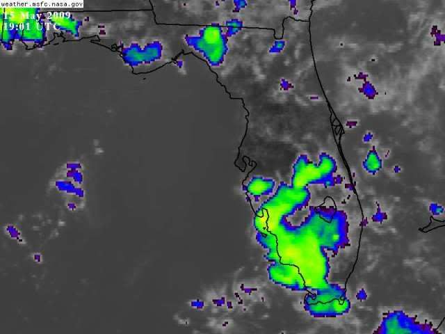
It looks like there is a large gap on the Western Coast of the peninsula, around the Tampa area...where no big thunderstorms are developing..
I recall when I lived in the Pinellas County area (northern) it was frustrating when you saw the activity to the north and south but the activity never made it far enough west....though it appears some light to moderate rain is falling in the East Lake area and NE Pinellas.
Florida Weather
Moderator: S2k Moderators
Forum rules

The posts in this forum are NOT official forecast and should not be used as such. They are just the opinion of the poster and may or may not be backed by sound meteorological data. They are NOT endorsed by any professional institution or STORM2K.
A normal rainy season doesn't crank up around here until about june 10th when a deep easterly flow becomes established... so these are bonus rounds. then we'll do well. the florida west coast, especially from sarasota to cedar key really does well in a reverse summertime flow as well during the summer. it was either 2002 or 2003 when about 90 inches fell here, much more than nearby tampa and much of it during the rainy season... repeated southwesterly flow dumped tons of nocturnal convection on us. My sidewalk was green! last year featured a lack of that setup. eventually we'll get dumped on. i missed a 2 inch dump by less than 15 miles last night.
0 likes
-
Tampa Bay Hurricane

- Category 5

- Posts: 5597
- Age: 38
- Joined: Fri Jul 22, 2005 7:54 pm
- Location: St. Petersburg, FL
-
Tampa Bay Hurricane
- Category 5
- Posts: 5597
- Age: 38
- Joined: Fri Jul 22, 2005 7:54 pm
- Location: St. Petersburg, FL
Re: Florida Weather Thread: Rainy season may have started
Very Ominous Clouds:
You can SEE VERY STRONG WINDS: Look closely the trees
are swinging
SE 44 G 53 mph!!! Albert Whitted
A few branches down in back yard
http://www.srh.noaa.gov/data/obhistory/KSPG.html


You can SEE VERY STRONG WINDS: Look closely the trees
are swinging
SE 44 G 53 mph!!! Albert Whitted
A few branches down in back yard
http://www.srh.noaa.gov/data/obhistory/KSPG.html


0 likes
-
JonathanBelles
- Professional-Met

- Posts: 11430
- Age: 35
- Joined: Sat Dec 24, 2005 9:00 pm
- Location: School: Florida State University (Tallahassee, FL) Home: St. Petersburg, Florida
- Contact:
-
JonathanBelles
- Professional-Met
- Posts: 11430
- Age: 35
- Joined: Sat Dec 24, 2005 9:00 pm
- Location: School: Florida State University (Tallahassee, FL) Home: St. Petersburg, Florida
- Contact:
Tornado in Temple Terrace yesterday rated an EF0...
http://www.srh.noaa.gov/images/tbw/TopN ... RMay13.pdf
http://www.srh.noaa.gov/images/tbw/TopN ... RMay13.pdf
0 likes
-
gatorcane

- S2K Supporter

- Posts: 23708
- Age: 48
- Joined: Sun Mar 13, 2005 3:54 pm
- Location: Boca Raton, FL
Re:
psyclone wrote:A normal rainy season doesn't crank up around here until about june 10th when a deep easterly flow becomes established... so these are bonus rounds. then we'll do well. the florida west coast, especially from sarasota to cedar key really does well in a reverse summertime flow as well during the summer. it was either 2002 or 2003 when about 90 inches fell here, much more than nearby tampa and much of it during the rainy season... repeated southwesterly flow dumped tons of nocturnal convection on us. My sidewalk was green! last year featured a lack of that setup. eventually we'll get dumped on. i missed a 2 inch dump by less than 15 miles last night.
The synoptic setup today for afternoon/evening thunderstorms for the West Coast of FL does not get any better, even in the middle of August during the rainy season. I took a look at some of the storm total maps and saw towns such as Palm Harbor, Dunedin, and Clearwater saw no rainfall. But if you had south down the peninsula into St. Petersburg and Pinellas Park, the story is different with plenty of rainfall and localized flooding.
I remember growing up as a kid, that happened often. I always felt the microclimate of North Pinellas County caused by its more distant proximity to the Bay and rolling hills/higher elevation did something to break apart alot of the bigger storms you would see farther south such as in Pinellas Park, Tampa, or inland. Of course these storms did not always break apart and there are times during the rainy season that big storms move through all of Pinellas County.
0 likes
Re: Re:
gatorcane wrote:psyclone wrote:A normal rainy season doesn't crank up around here until about june 10th when a deep easterly flow becomes established... so these are bonus rounds. then we'll do well. the florida west coast, especially from sarasota to cedar key really does well in a reverse summertime flow as well during the summer. it was either 2002 or 2003 when about 90 inches fell here, much more than nearby tampa and much of it during the rainy season... repeated southwesterly flow dumped tons of nocturnal convection on us. My sidewalk was green! last year featured a lack of that setup. eventually we'll get dumped on. i missed a 2 inch dump by less than 15 miles last night.
The synoptic setup today for afternoon/evening thunderstorms for the West Coast of FL does not get any better, even in the middle of August during the rainy season. I took a look at some of the storm total maps and saw towns such as Palm Harbor, Dunedin, and Clearwater saw no rainfall. But if you had south down the peninsula into St. Petersburg and Pinellas Park, the story is different with plenty of rainfall and localized flooding.
I remember growing up as a kid, that happened often. I always felt the microclimate of North Pinellas County caused by its more distant proximity to the Bay and rolling hills/higher elevation did something to break apart alot of the bigger storms you would see farther south such as in Pinellas Park, Tampa, or inland. Of course these storms did not always break apart and there are times during the rainy season that big storms move through all of Pinellas County.
I think you're way over thinking this. Northern pinellas was stabilized by a severe storm that developed in southern pasco county and travelled south into the east lake area before disipating. it could have just as easily developed over me (after all i am closer to the bay than the storm origination point). As for elevation, my whopping 20 foot elevation won't do much to disrupt a 40,000 foot thunderhead... that theory strikes me as goofy. When I lived in Largo I alway felt like I was getting the shaft and north county was hogging the rain so there's probably some psychology at work here too. In the short term, big discrepancies do develop but they always even out...that is the very nature of convective rainfall, hence my reference to the convective roulette wheel. sometimes you hit a streak like the lakeland area the last 3 days but over time it all evens out.
0 likes
Re: Florida Weather Thread: Rainy season may have started
One of the defining features of the 'rainy season' in south florida is that the dewpoint rises above 70 and remains above 70 for extended periods (if not always) of time....haven't hit that threshold yet...
From NWS Miami
For the more recent 33 years (1965-1997) when all three parameters were available, they were used in the following manner to determine the beginning of the summer season. The average daily dew point temperature was first examined to determine when it rose above and remained above 70oF. Of course, from this time on, the daily minimum temperatures remained above the 70oF level. The date when this took place was designated as the beginning of the summer season. In nearly all years, the summer rains began on or soon after that date.
Latest dewpoints (have been in the mid 60s to low 70s range for the past several days)
0 likes

Re:
I know that the southeast florida definition of rainy season is not used for central florida so it is possible that the 'rainy season' may have begun in that part of the state....but it hasn't in south florida yet. Getting close though....just need to get those dewpoints up a few more degrees...and have them stay there pretty much 24-7 going forward.
Also, given that Miami has seen 0.01" of rain month to date, Fort Lauderdale has seen 0.05" month to date, and West Palm has seen 0.03" month to date....not looking to rainy yet....key word being 'yet'.
Also, given that Miami has seen 0.01" of rain month to date, Fort Lauderdale has seen 0.05" month to date, and West Palm has seen 0.03" month to date....not looking to rainy yet....key word being 'yet'.
NDG wrote:Rainy season is here people, frontal boundary is long gone, nothing but summer like afternoon thunderstorms spawned by surface heating and seabreeze fronts along with the tropical moisture.
0 likes
Re: Florida Weather Thread: Rainy season may have started
Second day in a row afternoon heat drove convection that showered over us as the winds pushed it here from the mainland. Classic rainy season pattern.
0 likes
-
Evil Jeremy

- S2K Supporter
- Posts: 5463
- Age: 32
- Joined: Mon Apr 10, 2006 2:10 pm
- Location: Los Angeles, CA
Re: Florida Weather Thread: Rainy season may have started
No question (in my opinion) that we are now in rainy season mode. At least 30% rain for where I live for the next week is foretasted, including a 50% of rain tomorrow. Its that time of year again.
0 likes
-
DanKellFla

- Category 5
- Posts: 1291
- Joined: Fri Mar 17, 2006 12:02 pm
- Location: Lake Worth, Florida
It is about time! In some ways, it has been wonderful to have a late start to the rainy season. But, it has been brutal on the S. Fla water supply. Out of habit, I turned my spriklers off a month ago. Two weeks later, I had a brown lawn and had to turn my sprinklers on again. Hopefully, I can turn them off now for the rest of the summer.
Now, if I could only fix my lawnmower.
Now, if I could only fix my lawnmower.
0 likes
-
Tampa Bay Hurricane
- Category 5
- Posts: 5597
- Age: 38
- Joined: Fri Jul 22, 2005 7:54 pm
- Location: St. Petersburg, FL
http://radar.weather.gov/ridge/radar.ph ... 1&loop=yes
Huge storm over Sarasota county, entering Manatee...should
impact southern Pinellas by about 430 PM...
Severe thunderstorm west of Fort Myers...Watch out Sanibel
(I think that's where Sanibel Island is).
Huge storm over Sarasota county, entering Manatee...should
impact southern Pinellas by about 430 PM...
Severe thunderstorm west of Fort Myers...Watch out Sanibel
(I think that's where Sanibel Island is).
0 likes
-
Tampa Bay Hurricane
- Category 5
- Posts: 5597
- Age: 38
- Joined: Fri Jul 22, 2005 7:54 pm
- Location: St. Petersburg, FL
-
Tampa Bay Hurricane
- Category 5
- Posts: 5597
- Age: 38
- Joined: Fri Jul 22, 2005 7:54 pm
- Location: St. Petersburg, FL
-
HURAKAN

- Professional-Met
- Posts: 46084
- Age: 38
- Joined: Thu May 20, 2004 4:34 pm
- Location: Key West, FL
- Contact:
Miami WFO declared already the beginning of the rainy season:
http://www.srh.noaa.gov/images/mfl/news ... g_2009.pdf
http://www.srh.noaa.gov/images/mfl/news ... g_2009.pdf
0 likes
Return to “USA & Caribbean Weather”
Who is online
Users browsing this forum: Iceresistance and 49 guests