The NWS. For whatever it's worth. Says the low should head west. Slowly:
For the period of tonight through Friday...model guidance is in
good agreement that the stacked low will continue to move westward
into the central Gulf albeit slowly. This will keep fairly
moderate sserly flow through about 600mb or so through the period.
Precipitable waters remain between 1.5 and 2 inches...so at least scattered
convection is a good bet.
Florida Weather
Moderator: S2k Moderators
Forum rules

The posts in this forum are NOT official forecast and should not be used as such. They are just the opinion of the poster and may or may not be backed by sound meteorological data. They are NOT endorsed by any professional institution or STORM2K.
-
HURRICANELONNY
- Category 5

- Posts: 1390
- Joined: Wed May 07, 2003 6:48 am
- Location: HOLLYWOOD.FL
-
Tampa Bay Hurricane

- Category 5
- Posts: 5597
- Age: 38
- Joined: Fri Jul 22, 2005 7:54 pm
- Location: St. Petersburg, FL
-
WeatherLovingDoc

- S2K Supporter

- Posts: 453
- Joined: Fri Sep 05, 2008 10:08 pm
- Location: Washington D.C.
Re:
Tampa Bay Hurricane wrote:Torrential Rain and Wind
50-60 mph winds earlier snapped a tree in half in neighbor's yard
That's quite remarkable! I hope you all are inside.
0 likes
-
JonathanBelles
- Professional-Met

- Posts: 11430
- Age: 35
- Joined: Sat Dec 24, 2005 9:00 pm
- Location: School: Florida State University (Tallahassee, FL) Home: St. Petersburg, Florida
- Contact:
Re: Florida Weather Thread: 90L to impact FL wx
Looks like slide west instead of south.
If this was July I think we would have a good storm out of this tenacious system.
If this was July I think we would have a good storm out of this tenacious system.
0 likes
-
DanKellFla

- Category 5
- Posts: 1291
- Joined: Fri Mar 17, 2006 12:02 pm
- Location: Lake Worth, Florida
Re: Florida Weather Thread: 90L to impact FL wx
Sanibel wrote:Looks like slide west instead of south.
If this was July I think we would have a good storm out of this tenacious system.
I agree. It is spinning and has an eye-like structure. Plus, it is keeping me awake.
0 likes
-
Evil Jeremy

- S2K Supporter
- Posts: 5463
- Age: 32
- Joined: Mon Apr 10, 2006 2:10 pm
- Location: Los Angeles, CA
-
Bocadude85

- Category 5
- Posts: 2991
- Age: 39
- Joined: Mon Apr 18, 2005 2:20 pm
- Location: Honolulu,Hi
Re: Florida Weather Thread: 90L to impact FL wx
SPECIAL WEATHER STATEMENT
NATIONAL WEATHER SERVICE MIAMI FL
1012 AM EDT THU MAY 21 2009
FLZ067-068-072-168-172-211515-
INLAND PALM BEACH COUNTY FL-METRO PALM BEACH COUNTY FL-
COASTAL PALM BEACH COUNTY FL-METRO BROWARD COUNTY FL-
COASTAL BROWARD COUNTY FL-
1012 AM EDT THU MAY 21 2009
...STRONG THUNDERSTORMS MOVING ACROSS SOUTHEAST PALM BEACH AND
NORTHEAST BROWARD COUNTIES...
AT 1005 AM EDT...NATIONAL WEATHER SERVICE DOPPLER RADAR INDICATED A
CLUSTER OF STRONG THUNDERSTORMS FROM COCONUT CREEK TO NEAR BOCA
RATON...MOVING NORTHWEST AT 10 MPH. A REPORT WAS RECEIVED OF 53 MPH
AT 944 AM IN DEERFIELD BEACH. IN ADDITION, DOPPLER RADAR ESTIMATES
3 TO 5 INCHES WHICH WOULD INDICATE PONDING OF ROADWAYS AND
INTERSECTIONS.
At my work in Deerfield the winds were horrible... lost power for a few minutes and the palm fronds were stripped from the trees and now litter the roads... also the roads are underwater at the moment.
0 likes
-
Evil Jeremy
- S2K Supporter
- Posts: 5463
- Age: 32
- Joined: Mon Apr 10, 2006 2:10 pm
- Location: Los Angeles, CA
-
KG4HPN

- Tropical Depression

- Posts: 96
- Joined: Thu Aug 12, 2004 12:21 pm
- Location: New Smyrna Beach, FL
Re: Florida Weather Thread: 90L to impact FL wx
HI folks. I usually lurk on the TT boards May-Nov and didn't even realize this forum existed until today!
Here in the Daytona Beach area, we've had something on the order of 16 inches of rain since this all started Sunday night. Many retention ponds are flooded into roads, creating a huge mess. I've been keeping an eye on the radar and it seems that the rains might be tapering off a bit, but I'm hearing ya'll say it looks like the low is sliding south. There's been considerably heavier rain north of us and I'm wondering, does this mean that we're in for more heavier precip before this thing gets out of here?
Here in the Daytona Beach area, we've had something on the order of 16 inches of rain since this all started Sunday night. Many retention ponds are flooded into roads, creating a huge mess. I've been keeping an eye on the radar and it seems that the rains might be tapering off a bit, but I'm hearing ya'll say it looks like the low is sliding south. There's been considerably heavier rain north of us and I'm wondering, does this mean that we're in for more heavier precip before this thing gets out of here?
0 likes
Re: Florida Weather Thread: 90L to impact FL wx
Any future rain should be from bands rotating in around the Low and convecting up with daytime heating. In other words it ain't left yet.
0 likes
-
KG4HPN
- Tropical Depression
- Posts: 96
- Joined: Thu Aug 12, 2004 12:21 pm
- Location: New Smyrna Beach, FL
Re: Florida Weather Thread: 90L to impact FL wx
That much is clear! LOL
I live in New Smyrna and what I saw when I went to work this morning blew me away. On the way home last night I saw some mostly full drainage ditches and retention ponds, but very little actual flooding. We must have gotten some significant rain overnight, though, because this morning areas that had been bone dry last night were flooded significantly. Thank goodness our house is elevated so we have little worry in that regard, though we may have to park and walk since our yard is starting to flood.
At least here on the coast we haven't had the severe weather (for the most part) that some other folks have been experiencing. We've had a few gusty winds, but no tornadoes or nasty downbursts the way inland has.
0 likes
-
Bocadude85
- Category 5
- Posts: 2991
- Age: 39
- Joined: Mon Apr 18, 2005 2:20 pm
- Location: Honolulu,Hi
Re: Florida Weather Thread: 90L to impact FL wx
I wonder why a severe thunderstorm warning was not issued for that cell that moved ashore in NE Broward and SE Palm Beach Counties this morning? At my house here in Boca Raton... Palmetto and Powerline area many large trees are either snapped in half or uprooted.
0 likes
-
JonathanBelles
- Professional-Met
- Posts: 11430
- Age: 35
- Joined: Sat Dec 24, 2005 9:00 pm
- Location: School: Florida State University (Tallahassee, FL) Home: St. Petersburg, Florida
- Contact:
-
kevin
-
srainhoutx

- S2K Supporter
- Posts: 6919
- Age: 68
- Joined: Sun Jan 14, 2007 11:34 am
- Location: Haywood County, NC
- Contact:
Re: Florida Weather Thread: 90L to impact FL wx
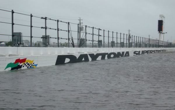
Talked to a friend in Daytona Beach last night. Here's a picture she sent that race fans will enjoy... 
0 likes
-
KG4HPN
- Tropical Depression
- Posts: 96
- Joined: Thu Aug 12, 2004 12:21 pm
- Location: New Smyrna Beach, FL
Re: Florida Weather Thread: 90L to impact FL wx
srainhoutx wrote:Talked to a friend in Daytona Beach last night. Here's a picture she sent that race fans will enjoy...
Holy cow!!!
(And that's the first time I've ever used that S2K catch phrase)
Is that going into turn 3?
0 likes
-
Evil Jeremy
- S2K Supporter
- Posts: 5463
- Age: 32
- Joined: Mon Apr 10, 2006 2:10 pm
- Location: Los Angeles, CA
Re: Florida Weather Thread: 90L to impact FL wx
I believe that is still the backstretch, nearing the entrance to turn 3. There is a race at Daytona about a month away, and if the rain continues, NASCAR fans (including myself) are not going to be happy lol.
0 likes
-
srainhoutx
- S2K Supporter
- Posts: 6919
- Age: 68
- Joined: Sun Jan 14, 2007 11:34 am
- Location: Haywood County, NC
- Contact:
Re: Florida Weather Thread: 90L to impact FL wx
BULLETIN - EAS ACTIVATION REQUESTED
FLASH FLOOD WARNING
NATIONAL WEATHER SERVICE MELBOURNE FL
807 AM EDT FRI MAY 22 2009
THE NATIONAL WEATHER SERVICE IN MELBOURNE HAS ISSUED A
* FLASH FLOOD WARNING FOR...
NORTHEASTERN VOLUSIA COUNTY IN FLORIDA...
THIS INCLUDES THE CITIES OF...NEW SMYRNA BEACH...SOUTH DAYTONA...
PORT ORANGE...PONCE INLET...ORMOND BEACH...HOLLY HILL...
EDGEWATER...DAYTONA BEACH...
* UNTIL 1100 AM EDT.
* AT 805 AM EDT...NATIONAL WEATHER SERVICE DOPPLER RADAR INDICATED
A PERSISTENT BAND OF SHOWERS AND STORMS MOVING ONSHORE FROM THE
ATLANTIC. THIS RAINFALL IS MOVING INTO AN AREA THAT HAS ALREADY
RECEIVED TORRENTIAL RAINFALL AMOUNTS IN THE PAST FEW DAYS AND
THE ADDITIONAL RAINS WILL ACT TO FURTHER WORSEN AN ALREADY
SERIOUS FLOODING SITUATION. ADDITIONAL RAINFALL AMOUNTS OF
TWO TO FOUR INCHES WITH ISOLATED HIGHER AMOUNTS MAY OCCUR THROUGH
LATE MORNING. PERSONS IN THESE AREAS SHOULD TAKE QUICK ACTION TO
PROTECT LIFE AND PROPERTY.
0 likes
-
KG4HPN
- Tropical Depression
- Posts: 96
- Joined: Thu Aug 12, 2004 12:21 pm
- Location: New Smyrna Beach, FL
Re: Florida Weather Thread: 90L to impact FL wx
Evil Jeremy wrote:I believe that is still the backstretch, nearing the entrance to turn 3. There is a race at Daytona about a month away, and if the rain continues, NASCAR fans (including myself) are not going to be happy lol.
Yep, I'm well aware of that, since I live and work in the area and am also a race fan. I think it's safe to say that they've "lost the track".

0 likes
Return to “USA & Caribbean Weather”
Who is online
Users browsing this forum: MetroMike and 22 guests