Global model runs discussion

Moderator: S2k Moderators

Message
Author
User avatar
cycloneye
Admin
Admin
Posts: 143877
Age: 68
Joined: Thu Oct 10, 2002 10:54 am
Location: San Juan, Puerto Rico

Re:

#421 Postby cycloneye » Sat Aug 01, 2009 12:53 pm

Derek Ortt wrote:thought the UKMET was not being plotted on that page anymore. Doesn't show up on the main page

At the links to other models,after bin/ you put ukm and that is it.

bin/ukm
0 likes   

User avatar
gatorcane
S2K Supporter
S2K Supporter
Posts: 23689
Age: 47
Joined: Sun Mar 13, 2005 3:54 pm
Location: Boca Raton, FL

#422 Postby gatorcane » Sat Aug 01, 2009 1:23 pm

00Z ECMWF shows this low (albeit weak) also at 216 hours out, heading west into the MDR.

With three models showing some kind of weak low from a tropical wave, it will bear watching -- but we are about 7-10 days from it happening....and not by coincidence when the true Cape Verde season begins..

http://www.ecmwf.int/products/forecasts ... 9080100!!/
0 likes   

Ed Mahmoud

Re: Long / Medium Range Model Runs

#423 Postby Ed Mahmoud » Sat Aug 01, 2009 1:46 pm

DOUBLE POST ALERT


Joe Bastardi says, in his opinion, based on the SOI change and the upward motion pulse, there will be a brief window of opportunity around mid-August for something to develop, before the SOI change occuring now leads to the door slamming shut in late August into September.


I don't know why, except for the CPAC near misses (and Iniki was a September storm and Iwa was a November storm, so Hawai'i has loads of hurricane season left) this will be a real low number 1992 type season.

And with coastlines in 3 directions, I have to think Florida has the best shot of a storm.

I'm thinking, based on days without electricity after Ike and sleeping on sweat soaked sheets in my boxers, and this after a cool front passed, an August hurricane without air conditioning would be really unpleasant.


Joe Bastardi says he has alerted his big money customers of an expected threat, but exactly where, his $100/year clients like me, he didn't say. But he has been alluding to either the Southeast or Northeast since April.


ETA:

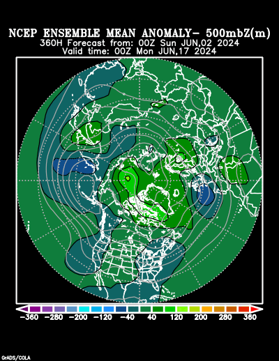
JB left this URL from the ensemble site as a clue:
http://www.cdc.noaa.gov/map/images/ens/z500anom_f360_nh.html

Image
0 likes   

Ed Mahmoud

Re: Long / Medium Range Model Runs

#424 Postby Ed Mahmoud » Sat Aug 01, 2009 2:02 pm

Image Nice wave in 1 week Mid-Atlantic

40 knot low level Easterlies in the Caribbean would not seem favorable if this makes it that far, both as far as convergence goes and faster wave motion/shear.

Not much at the 500 mb level yet, so it should be steered shallow, or generally Westward.
Image

Light flow aloft
Image

Looking beyond the 180 hour wave reduction resolution lobotomy...

Weakens and moved WNW to NW
Image
0 likes   

User avatar
cycloneye
Admin
Admin
Posts: 143877
Age: 68
Joined: Thu Oct 10, 2002 10:54 am
Location: San Juan, Puerto Rico

Re: Long / Medium Range Model Runs

#425 Postby cycloneye » Sat Aug 01, 2009 2:07 pm

12z EURO has closed low

Is the first time that the ECMWF model,(The best in 2009 IMO) has a closed low and sustains it for the majority of the run.

12z ECMWF
0 likes   

Ed Mahmoud

Re: Long / Medium Range Model Runs

#426 Postby Ed Mahmoud » Sat Aug 01, 2009 2:37 pm

Not much of a closed low, and it weakens it day 7 through day 10, so on day 10 it doesn't even show one of its 5 mb/division isobars closed around it.


But it is a start. And the size of the area of the 30 knot plus Easterlies screaming across the Caribbean is shrinking, so at least as far as shear and surface convergence, the area near and East of the Caribbean should be less hostile.


ETA: The GFS also weakens it after a week, but I assume (could be making a me of u and an, nevermind) that is a artifact of the resolution reduction at tau 180.
0 likes   

User avatar
gatorcane
S2K Supporter
S2K Supporter
Posts: 23689
Age: 47
Joined: Sun Mar 13, 2005 3:54 pm
Location: Boca Raton, FL

Re: Long / Medium Range Model Runs

#427 Postby gatorcane » Sat Aug 01, 2009 2:39 pm

Ed Mahmoud wrote:Not much of a closed low, and it weakens it day 7 through day 10, so on day 10 it doesn't even show one of its 5 mb/division isobars closed around it.


But it is a start. And the size of the area of the 30 knot plus Easterlies screaming across the Caribbean is shrinking, so at least as far as shear and surface convergence, the area near and East of the Caribbean should be less hostile.


What's important is that it along with GFS and CMC show some kind of weak closed low also. Forget about 10+ days out, that will likely change as models get a better handle on the situation...... I think this could be a real shot of something here for the first time in 2009.
0 likes   

User avatar
srainhoutx
S2K Supporter
S2K Supporter
Posts: 6919
Age: 67
Joined: Sun Jan 14, 2007 11:34 am
Location: Haywood County, NC
Contact:

Re: Long / Medium Range Model Runs

#428 Postby srainhoutx » Sat Aug 01, 2009 3:00 pm

Remember, the MJO goes positive in the Atlantic Basin around mid August. :wink:
0 likes   

User avatar
cycloneye
Admin
Admin
Posts: 143877
Age: 68
Joined: Thu Oct 10, 2002 10:54 am
Location: San Juan, Puerto Rico

Re: Long / Medium Range Model Runs

#429 Postby cycloneye » Sat Aug 01, 2009 6:43 pm

18z GFS ensemble track starts at the 4th.

Image

http://www.emc.ncep.noaa.gov/gmb/tpm/em ... single.gif
0 likes   

jinftl
Category 5
Category 5
Posts: 4312
Joined: Tue Aug 31, 2004 4:47 pm
Location: fort lauderdale, fl

Re: Long / Medium Range Model Runs

#430 Postby jinftl » Sat Aug 01, 2009 7:19 pm

Watch the trend from model run to model run....the most recent (18z), prior run (12z), and the run prior to that one (6z) are trending more west with whatever this system may be

Most recent (18z):
Image

Prior run (12z):
Image

2 runs prior to current (6z):
Image
0 likes   

Dean4Storms
S2K Supporter
S2K Supporter
Posts: 6358
Age: 62
Joined: Sun Aug 31, 2003 1:01 pm
Location: Miramar Bch. FL

#431 Postby Dean4Storms » Sat Aug 01, 2009 8:46 pm

It does look like a track toward maybe the NE Carib. if it materializes as the last run indicates. But this will likely change 10fold if we get anything at all!
0 likes   

Ed Mahmoud

Re: Long / Medium Range Model Runs

#432 Postby Ed Mahmoud » Sat Aug 01, 2009 11:03 pm

DOUBLE POST ALERT


Bed time approaches, don't want to be yawning at Mass...


GFS has started, and has a nice disturbance, closed at 850 mb, in 3 days.

Image

ETA:

No idea if I believe it, but it is a 25 knot TD then...

Image

This is hotlinked (I know, I know, Photobucket), but the thread should be on a new page by this time tomorrow...
0 likes   

User avatar
cycloneye
Admin
Admin
Posts: 143877
Age: 68
Joined: Thu Oct 10, 2002 10:54 am
Location: San Juan, Puerto Rico

Re: Long / Medium Range Model Runs

#433 Postby cycloneye » Sun Aug 02, 2009 11:52 am

GFS continues with its convective feedback as it shows some areas at the start of this 12z run.It has a weak low moving west,then turning NW around 45W,but nothing much stromger. In the long range period,it shows a parade of lows emerging Africa,but the developments with those is weak.We know the drill after 144 hours. :)

http://www.nco.ncep.noaa.gov/pmb/nwprod ... loop.shtml

The Canadian model at the 12z run shows some flashes of something,but anything that may cause you to open your eyes. :)

http://moe.met.fsu.edu/cgi-bin/cmctc2.c ... =Animation

12z UKMET shows the same flashes as the Canadian.

http://moe.met.fsu.edu/cgi-bin/ukmtc2.c ... =Animation
0 likes   

User avatar
cycloneye
Admin
Admin
Posts: 143877
Age: 68
Joined: Thu Oct 10, 2002 10:54 am
Location: San Juan, Puerto Rico

Re: Long / Medium Range Model Runs

#434 Postby cycloneye » Sun Aug 02, 2009 1:21 pm

Here are the tracks of UKMET,CMC and GFS at their 12z runs.UKMET and GFS start at the 4th and CMC starts tracking on the 6th.

Image
0 likes   

User avatar
SEASON_CANCELED
Category 3
Category 3
Posts: 887
Joined: Mon Jul 06, 2009 5:17 am
Location: 8 Bit Charlie Sheen

Re: Long / Medium Range Model Runs

#435 Postby SEASON_CANCELED » Sun Aug 02, 2009 1:48 pm

geez what a season. Edge of my seat :lol:


Looks like models are finally converging on something. That system rolling off africa
0 likes   

User avatar
cycloneye
Admin
Admin
Posts: 143877
Age: 68
Joined: Thu Oct 10, 2002 10:54 am
Location: San Juan, Puerto Rico

Re: Long / Medium Range Model Runs

#436 Postby cycloneye » Sun Aug 02, 2009 2:37 pm

The 12z EURO hangs on a low for a pretty long time but it vanishes at the end of run.

12z ECMWF

The summary of the 12z runs that have some form of development and those that dont have anything.

1-GFS+Yes
2-CMC=Yes
3-UKMET=Yes
4-NOGAPS=No
5-ECMWF=Yes
0 likes   

Derek Ortt

#437 Postby Derek Ortt » Sun Aug 02, 2009 5:12 pm

maybe my dream of a 3 storm season will come true
0 likes   

User avatar
gatorcane
S2K Supporter
S2K Supporter
Posts: 23689
Age: 47
Joined: Sun Mar 13, 2005 3:54 pm
Location: Boca Raton, FL

Re: Long / Medium Range Model Runs

#438 Postby gatorcane » Sun Aug 02, 2009 5:16 pm

cycloneye wrote:The 12z EURO hangs on a low for a pretty long time but it vanishes at the end of run.

12z ECMWF

The summary of the 12z runs that have some form of development and those that dont have anything.

1-GFS+Yes
2-CMC=Yes
3-UKMET=Yes
4-NOGAPS=No
5-ECMWF=Yes


So far the model consensus is quite good. I do believe we are going to have something to track here in about 7-10 days from now (a Cape Verde system it appears), and as expected the board will come to life again. If it forms into a named system it would be closer to the end of that range, probably anywhere in the Aug. 10-15th range.....


Here is another view of the ECMWF, with the system headed in the general direction of the NE Caribbean, or to the are just NE of the Leewards.

http://www.ecmwf.int/products/forecasts ... 9080212!!/
0 likes   

jinftl
Category 5
Category 5
Posts: 4312
Joined: Tue Aug 31, 2004 4:47 pm
Location: fort lauderdale, fl

Re:

#439 Postby jinftl » Sun Aug 02, 2009 5:41 pm

What are you seeing that makes a 3-storm season seem a potentially realized dream? Not being facetious....there is no denying we are in a weak el nino now, and this could become a moderate one in the fall. but that alone wouldn't even make a 3-storm season seem a reasonable forecast. The season during the strongest el nino in recent memory back in 1997 had 8 named storms.

Be curious to hear your take on what other factors may not only be present now, but will persist enough to 'shut the season done' effectivey? What on August 2nd indicates a potential season storm total so low that would make this is a once or twice in a hundred year-type occurrence or was this just a Sunday afternoon daydream?


p.s. Why not go all out and have a 0 storm season dream? dream big!!!

Derek Ortt wrote:maybe my dream of a 3 storm season will come true
0 likes   

Derek Ortt

#440 Postby Derek Ortt » Sun Aug 02, 2009 7:08 pm

did you not see the word maybe

I in no way am forecasting this... mere wishing on my part
0 likes   


Return to “2015”

Who is online

Users browsing this forum: No registered users and 35 guests