Models Developing a Strong Tropical Wave to Move Off Africa
Moderator: S2k Moderators
Forum rules
The posts in this forum are NOT official forecasts and should not be used as such. They are just the opinion of the poster and may or may not be backed by sound meteorological data. They are NOT endorsed by any professional institution or STORM2K. For official information, please refer to products from the National Hurricane Center and National Weather Service.
-
Aric Dunn
- Category 5

- Posts: 21238
- Age: 43
- Joined: Sun Sep 19, 2004 9:58 pm
- Location: Ready for the Chase.
- Contact:
just got done looking at close up visible loop of the system and it is very impressive. seems to be a very well defined area developing, with a broad center showing signs of organizing near 10-11N and 19-20W.
All seems to be in place, with plenty of moisture and sst's are 28c and sal is well north. The models have this as a depression storm in as little as 24 hours, which seem reasonable at this current rate of organization.
All seems to be in place, with plenty of moisture and sst's are 28c and sal is well north. The models have this as a depression storm in as little as 24 hours, which seem reasonable at this current rate of organization.
0 likes
-
Aric Dunn
- Category 5

- Posts: 21238
- Age: 43
- Joined: Sun Sep 19, 2004 9:58 pm
- Location: Ready for the Chase.
- Contact:
Re: Models Developing a Strong Tropical Wave to Move Off Africa
latest visible loops of the wave..
and image of broad area of low pressure that is quickly forming..

banding is becoming evident... but it still has some organizing at the surface to do but is quickly doing so...

and image of broad area of low pressure that is quickly forming..
banding is becoming evident... but it still has some organizing at the surface to do but is quickly doing so...

0 likes
Re: Models Developing a Strong Tropical Wave to Move Off Africa
Interesting San Juan discussion
AREA FORECAST DISCUSSION
NATIONAL WEATHER SERVICE SAN JUAN PR
209 PM AST WED AUG 12 2009
...
THE
NEXT...AND LARGER TROPICAL WAVE HAVING JUST EXITED THE AFRICAN COAST
IS THE MAIN ISSUE OF CONCERN. SEVERAL MODELS HAVE BEEN CONSISTENT
FOR SEVERAL RUNS NOW IN DEVELOPING A DEEP SYSTEM...TRACKING IT
ACROSS THE TROPICAL ATLC AND INTO THE EASTERN CARIBBEAN BY NEXT
TUESDAY OR WEDNESDAY. ALTHOUGH TRACK IS IMPOSSIBLE TO PREDICT AT
THIS POINT...GFS AND EURO MODELS SHOWING SURPRISING RUN TO RUN
CONSISTENCY MUCH IN THE SAME WAY THEY HAD PERFORMED PRE HURRICANE
DEAN IN 2007. WE ARE RAPIDLY APPROACHING THE CLIMATOLOGICAL PEAK
OF HURRICANE SEASON...AND THIS IS THE PERFECT TIME TO GO OVER YOUR
SEASONAL PLANS AND MAKE SURE YOU ARE READY. FORECAST TRACKS...ONCE
ISSUED...WILL CHANGE AND SHOULD NOT BE RELIED ON FOR LONGER RANGE
PREPARATIONS.
0 likes
- PTrackerLA
- Category 5

- Posts: 5281
- Age: 42
- Joined: Thu Oct 10, 2002 8:40 pm
- Location: Lafayette, LA
Re: Models Developing a Strong Tropical Wave to Move Off Africa
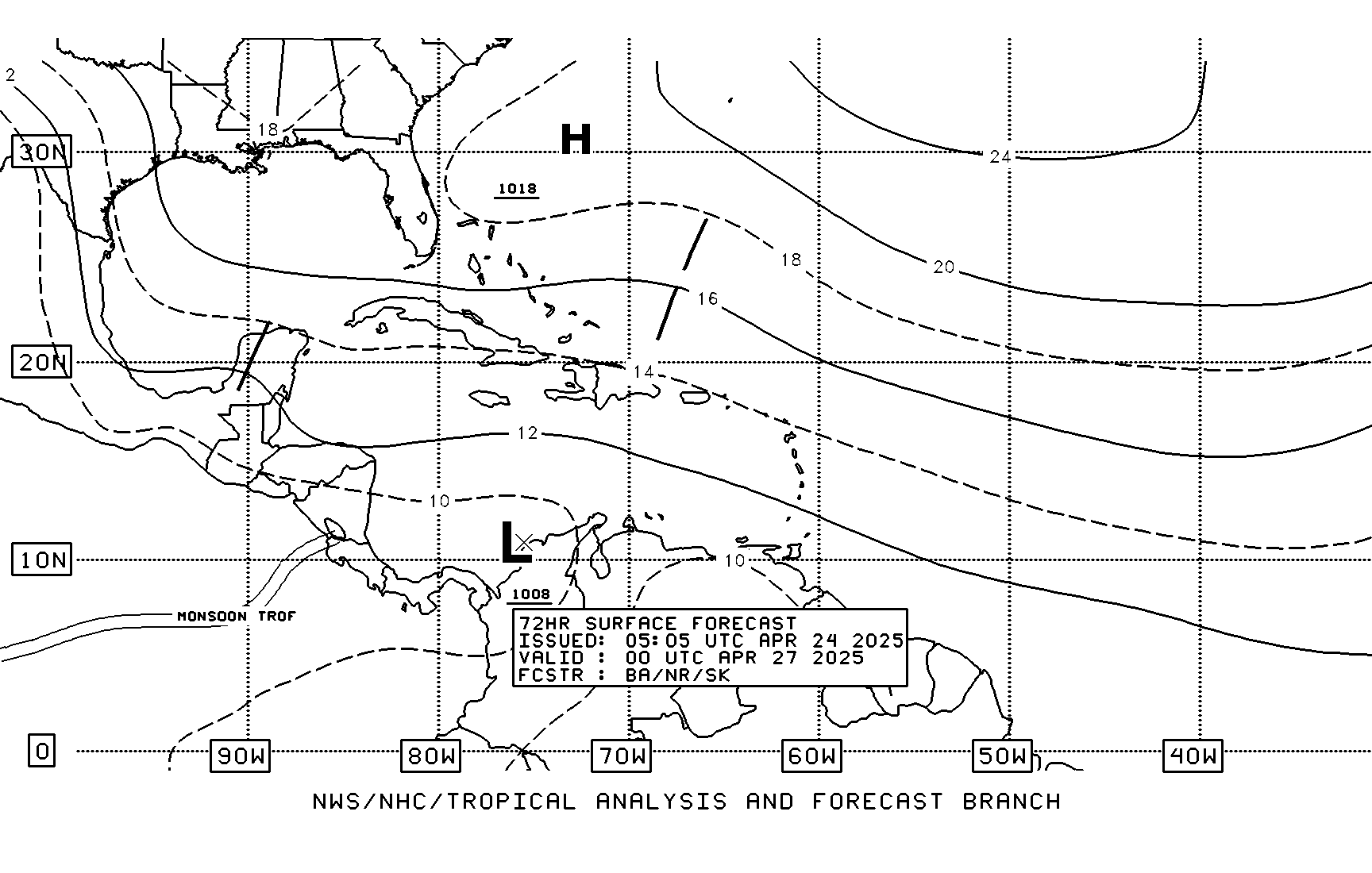
TAFB 72 hr forecast - looks like NHC looking at development - expect 90L soon.


0 likes
- cycloneye
- Admin

- Posts: 149579
- Age: 69
- Joined: Thu Oct 10, 2002 10:54 am
- Location: San Juan, Puerto Rico
Re: Models Developing a Strong Tropical Wave to Move Off Africa
12z ECMWF=Strong hurricane for Bahamas
Not before it brushes the northern Leewards.
http://www.ecmwf.int/products/forecasts ... 12!!!step/
Not before it brushes the northern Leewards.
http://www.ecmwf.int/products/forecasts ... 12!!!step/
0 likes
-
Wx_Warrior
- Category 5

- Posts: 2718
- Joined: Thu Aug 03, 2006 3:58 pm
- Location: Beaumont, TX
-
Aric Dunn
- Category 5

- Posts: 21238
- Age: 43
- Joined: Sun Sep 19, 2004 9:58 pm
- Location: Ready for the Chase.
- Contact:
hey... there is a criteria for invests as well... something like 24hrs for any system .. typically they wait for invest till it as least sustains some sort of potential for 24 hrs and thing just hit the water maybe 12 hours ago.. lol so it will be up by later or tomorrow.. although if they wait too long they will have to issue TCFA at the same time.. lol
0 likes
-
Aric Dunn
- Category 5

- Posts: 21238
- Age: 43
- Joined: Sun Sep 19, 2004 9:58 pm
- Location: Ready for the Chase.
- Contact:
Re: Models Developing a Strong Tropical Wave to Move Off Africa
cycloneye wrote:12z ECMWF=Strong hurricane for Bahamas
Not before it brushes the northern Leewards.
http://www.ecmwf.int/products/forecasts ... 12!!!step/
looks like it starts turning before the bahamas.... hard to tell from that angle..
0 likes
-
CrazyC83
- Professional-Met

- Posts: 34315
- Joined: Tue Mar 07, 2006 11:57 pm
- Location: Deep South, for the first time!
Re: Models Developing a Strong Tropical Wave to Move Off Africa
Aric Dunn wrote:cycloneye wrote:12z ECMWF=Strong hurricane for Bahamas
Not before it brushes the northern Leewards.
http://www.ecmwf.int/products/forecasts ... 12!!!step/
looks like it starts turning before the bahamas.... hard to tell from that angle..
Such a turn would likely send it paralleling the Eastern Seaboard...
0 likes
- Evil Jeremy
- S2K Supporter

- Posts: 5463
- Age: 32
- Joined: Mon Apr 10, 2006 2:10 pm
- Location: Los Angeles, CA
Re: Models Developing a Strong Tropical Wave to Move Off Africa
I am shocked this is not an Invest already. This thing is orginizing quickly, and the NHC is already giving it a code orange. I have no doubts this will be an invest before the day is done.
0 likes
- Emmett_Brown
- Category 5

- Posts: 1433
- Joined: Wed Aug 24, 2005 9:10 pm
- Location: Sarasota FL
Re: Models Developing a Strong Tropical Wave to Move Off Africa
cycloneye wrote:12z ECMWF=Strong hurricane for Bahamas
Not before it brushes the northern Leewards.
http://www.ecmwf.int/products/forecasts ... 12!!!step/
The 500 mb version of the ECMWF loop clearly shows the trough, but i cant tell if the trough is deepening or pulling out by the time the storm gets there:
http://www.ecmwf.int/products/forecasts/d/animate/catalog/products/forecasts/medium/deterministic/msl_uv850_z500!Geopotential%20500%20hPa!240!North%20America!pop!od!oper!public_plots!2009081212!!step/
0 likes
- cycloneye
- Admin

- Posts: 149579
- Age: 69
- Joined: Thu Oct 10, 2002 10:54 am
- Location: San Juan, Puerto Rico
Re: Models Developing a Strong Tropical Wave to Move Off Africa
Look how this is organizing.


0 likes
-
Wx_Warrior
- Category 5

- Posts: 2718
- Joined: Thu Aug 03, 2006 3:58 pm
- Location: Beaumont, TX
- Bocadude85
- Category 5

- Posts: 2991
- Age: 39
- Joined: Mon Apr 18, 2005 2:20 pm
- Location: Honolulu,Hi
Re: Models Developing a Strong Tropical Wave to Move Off Africa
Aric Dunn wrote:cycloneye wrote:12z ECMWF=Strong hurricane for Bahamas
Not before it brushes the northern Leewards.
http://www.ecmwf.int/products/forecasts ... 12!!!step/
looks like it starts turning before the bahamas.... hard to tell from that angle..
Come on guys we all know these models are going to change a million times before we start to get a good idea of where the system will end up. Also it seems to me that models almost always over amplify a trough
0 likes
-
Stormcenter
- S2K Supporter

- Posts: 6689
- Joined: Wed Sep 03, 2003 11:27 am
- Location: Houston, TX
Re: Models Developing a Strong Tropical Wave to Move Off Africa
It's still pretty difficult to see where a possible center may be forming or what
direction it's moving in. IMO
direction it's moving in. IMO
cycloneye wrote:Look how this is organizing.
0 likes
- Emmett_Brown
- Category 5

- Posts: 1433
- Joined: Wed Aug 24, 2005 9:10 pm
- Location: Sarasota FL
Re: Models Developing a Strong Tropical Wave to Move Off Africa
cycloneye wrote:Look how this is organizing.
Is it me, or does future 90L look like it is moving faster than Ana? Wonder if Ana is going to be ingested by future Bill. Will be fascinating to watch.
0 likes
Who is online
Users browsing this forum: Astromanía and 107 guests


