ATL: TROPICAL STORM BILL (03L)
Moderator: S2k Moderators
-
vbhoutex

- Storm2k Executive

- Posts: 29149
- Age: 74
- Joined: Wed Oct 09, 2002 11:31 pm
- Location: Cypress, TX
- Contact:
Re: ATL: HURRICANE BILL (03L)
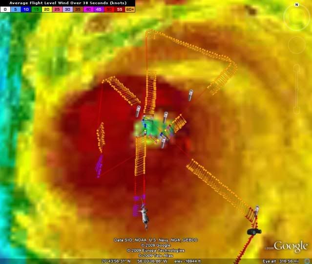
This is the bouy nearest to Bill. http://www.ndbc.noaa.gov/station_page.php?station=41044
0 likes

Re: ATL : BILL (03L) Recon Thread
UZNT13 KWBC 200103
XXAA 70012 99150 70599 04259 99009 28047 22004 00084 27241 21504
92770 22456 21505 85502 18047 23006 70142 10868 24008 50587 04571
21009 40759 15978 25013 30970 30180 01510 25097 40573 00508 88999
77999
31313 09608 80047
61616 NOAA9 WX03A BILL4 OB 18
62626 SPL 1500N05989W 0101 MBL WND 21504 AEV 20801 LAST REPORT OB
S 01 THRU 18 TO KWBC DLM WND 24504 008216 WL150 21004 084 REL 149
9N05990W 004749 SPG 1500N05989W 010100 =
XXBB 70018 99150 70599 04259 00009 28047 11942 22417 22921 22458
33894 21259 44850 18047 55803 15644 66777 14660 77761 13457 88737
13067 99712 10860 11694 11288 22667 09891 33597 03867 44574 02082
55506 03981 66494 05368 77457 08385 88344 21986
21212 00009 22004 11850 23006 22805 23010 33794 21510 44763 23512
55729 21514 66600 23013 77580 20514 88550 19511 99429 26010 11420
24512 22399 25013 33390 24013 44381 23510 55342 00502 66299 01510
77271 35511 88259 00511 99231 32006
31313 09608 80047
61616 NOAA9 WX03A BILL4 OB 18
62626 SPL 1500N05989W 0101 MBL WND 21504 AEV 20801 LAST REPORT OB
S 01 THRU 18 TO KWBC DLM WND 24504 008216 WL150 21004 084 REL 149
9N05990W 004749 SPG 1500N05989W 010100 =
0 likes
-
Squarethecircle
- Category 5

- Posts: 2165
- Joined: Fri Oct 19, 2007 4:00 pm
- Location: Fairfax, VA
Re:
The Eye Wall wrote:Whoa, wait just a second. I never said it wasn't a Cat. 4. Calm down.
Still, using satellite presentation for wind speed when there is recon in the storm is quite silly, don't you think?
0 likes
-
The Eye Wall
Re: ATL: HURRICANE BILL (03L)
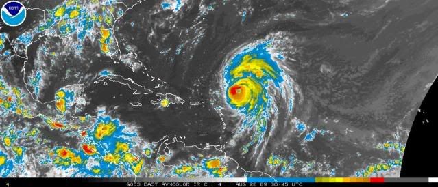
I retract my earlier statement. I just went and looked at a Satellite pic of it. The last I saw was hours and hours old. Cat 4, yes. High end? No.
0 likes
-
The Eye Wall
Re: Re:
Squarethecircle wrote:The Eye Wall wrote:Whoa, wait just a second. I never said it wasn't a Cat. 4. Calm down.
Still, using satellite presentation for wind speed when there is recon in the storm is quite silly, don't you think?
WTF? I was basing it off the way it looked earlier. Calm down. And yes, you can judge a book by its cover on some accounts. You can look at Bill and clearly see it's a mature hurricane vs. say Claudette. See the point?
0 likes


Re: ATL: HURRICANE BILL (03L)
Lyons on TWC said Bill is gonna move NNW tonite due to the ULL to the NW effecting it
he didn't think it was gonna hit New england or really make it that close....when he did the "hand" thing....i.e "will curve around like this"
he didn't think it was gonna hit New england or really make it that close....when he did the "hand" thing....i.e "will curve around like this"
0 likes
-
The Eye Wall
Re: ATL: HURRICANE BILL (03L)
A couple things. Yes, Bill is a Cat. 4. As stated in an earlier post yesterday, I stated that one of the things to look for is symmetry in the structure. Bill has got that, hands down. It has a very tight, small, eye completely surrounded by deep convection. However, the cloud tops, while cold, are not overly intense.
Also stated yesterday is the cloud pattern. Notice the clouds being pulled further and further north. Bill will soon feel the affects of that weakness and Bill will be headed north. This cloud motion is always a good indicator of future direction.

Also stated yesterday is the cloud pattern. Notice the clouds being pulled further and further north. Bill will soon feel the affects of that weakness and Bill will be headed north. This cloud motion is always a good indicator of future direction.
0 likes

Re:
HURAKAN wrote:Glad to be back!
Welcome back!
URNT15 KWBC 200105
NOAA3 WX03A BILL4 HDOB 28 20090820
005600 1846N 05820W 6966 03127 0006 +101 +085 258046 047 999 999 03
005630 1844N 05820W 6967 03129 0011 +099 +090 257045 045 999 999 03
005700 1842N 05820W 6965 03133 0013 +099 +089 256044 045 999 999 03
005730 1840N 05820W 6947 03156 0016 +096 +093 258043 044 999 999 03
005800 1838N 05820W 6948 03157 0020 +095 +089 256041 042 999 999 03
005830 1836N 05820W 6945 03161 0020 +094 +094 253040 042 043 017 03
005900 1834N 05820W 6950 03154 0030 +088 +088 255036 038 048 022 00
005930 1832N 05821W 6906 03207 0032 +083 +083 243035 041 050 018 00
010000 1831N 05821W 6938 03172 0040 +082 +082 245043 044 999 999 03
010030 1829N 05821W 6948 03165 0042 +086 +080 247041 042 999 999 03
010100 1827N 05821W 6951 03165 0041 +090 +080 248038 039 999 999 03
010130 1825N 05821W 6946 03170 0041 +089 +083 248038 039 999 999 03
010200 1824N 05819W 6949 03168 0035 +096 +075 250040 041 999 999 03
010230 1825N 05817W 6949 03169 0035 +096 +073 246040 041 999 999 03
010300 1826N 05815W 6949 03169 0036 +096 +072 243041 041 999 999 03
010330 1827N 05812W 6947 03170 0030 +100 +071 241041 041 999 999 03
010400 1829N 05810W 6946 03172 0030 +100 +071 240041 042 999 999 03
010430 1830N 05808W 6948 03169 0030 +101 +070 237043 043 999 999 03
010500 1831N 05806W 6946 03171 0029 +100 +071 235044 044 999 999 03
010530 1832N 05804W 6946 03171 0033 +097 +074 236045 045 999 999 03
Code: Select all
TIME         Latit.    Long.    Plane. Prs.   Height   Pressure   Temp   Dew Pt.   Dir, 30s mean   FL    SFMR   Precip   QC
5:60:00z   18.46°N   58.20°W   696.6 hPa   3127m   1000.6 hPa   10.1°C   8.5°C   258° @ 046kt   47kt   999kt   999mm   Suspect
5:63:30z   18.44°N   58.20°W   696.7 hPa   3129m   1001.1 hPa   9.9°C   9.0°C   257° @ 045kt   45kt   999kt   999mm   Suspect
5:70:00z   18.42°N   58.20°W   696.5 hPa   3133m   1001.3 hPa   9.9°C   8.9°C   256° @ 044kt   45kt   999kt   999mm   Suspect
5:73:30z   18.40°N   58.20°W   694.7 hPa   3156m   1001.6 hPa   9.6°C   9.3°C   258° @ 043kt   44kt   999kt   999mm   Suspect
5:80:00z   18.38°N   58.20°W   694.8 hPa   3157m   1002.0 hPa   9.5°C   8.9°C   256° @ 041kt   42kt   999kt   999mm   Suspect
5:83:30z   18.36°N   58.20°W   694.5 hPa   3161m   1002.0 hPa   9.4°C   9.4°C   253° @ 040kt   42kt   43kt   17mm   Suspect
5:90:00z   18.34°N   58.20°W   695.0 hPa   3154m   1003.0 hPa   8.8°C   8.8°C   255° @ 036kt   38kt   48kt   22mm   OK
5:93:30z   18.32°N   58.21°W   690.6 hPa   3207m   1003.2 hPa   8.3°C   8.3°C   243° @ 035kt   41kt   50kt   18mm   OK
1:00:00z   18.31°N   58.21°W   693.8 hPa   3172m   1004.0 hPa   8.2°C   8.2°C   245° @ 043kt   44kt   999kt   999mm   Suspect
1:00:30z   18.29°N   58.21°W   694.8 hPa   3165m   1004.2 hPa   8.6°C   8.0°C   247° @ 041kt   42kt   999kt   999mm   Suspect
1:01:00z   18.27°N   58.21°W   695.1 hPa   3165m   1004.1 hPa   9.0°C   8.0°C   248° @ 038kt   39kt   999kt   999mm   Suspect
1:01:30z   18.25°N   58.21°W   694.6 hPa   3170m   1004.1 hPa   8.9°C   8.3°C   248° @ 038kt   39kt   999kt   999mm   Suspect
1:02:00z   18.24°N   58.19°W   694.9 hPa   3168m   1003.5 hPa   9.6°C   7.5°C   250° @ 040kt   41kt   999kt   999mm   Suspect
1:02:30z   18.25°N   58.17°W   694.9 hPa   3169m   1003.5 hPa   9.6°C   7.3°C   246° @ 040kt   41kt   999kt   999mm   Suspect
1:03:00z   18.26°N   58.15°W   694.9 hPa   3169m   1003.6 hPa   9.6°C   7.2°C   243° @ 041kt   41kt   999kt   999mm   Suspect
1:03:30z   18.27°N   58.12°W   694.7 hPa   3170m   1003.0 hPa   10.0°C   7.1°C   241° @ 041kt   41kt   999kt   999mm   Suspect
1:04:00z   18.29°N   58.10°W   694.6 hPa   3172m   1003.0 hPa   10.0°C   7.1°C   240° @ 041kt   42kt   999kt   999mm   Suspect
1:04:30z   18.30°N   58.08°W   694.8 hPa   3169m   1003.0 hPa   10.1°C   7.0°C   237° @ 043kt   43kt   999kt   999mm   Suspect
1:05:00z   18.31°N   58.06°W   694.6 hPa   3171m   1002.9 hPa   10.0°C   7.1°C   235° @ 044kt   44kt   999kt   999mm   Suspect
1:05:30z   18.32°N   58.04°W   694.6 hPa   3171m   1003.3 hPa   9.7°C   7.4°C   236° @ 045kt   45kt   999kt   999mm   Suspect
UZNT13 KWBC 200106
XXAA 70017 99193 70583 04298 99994 260// 24547 00554 ///// /////
92630 21402 25552 85362 18003 26048 70011 110// 24553 88999 77999
31313 09608 80047
61616 NOAA3 WX03A BILL4 OB 16
62626 REL 1932N05832W 004731 SPG 1934N05826W 005141 WL150 24050 0
85 DLM WND 25051 993697 MBL WND 24051=
XXBB 70018 99193 70583 04298 00994 260// 11993 25814 22928 21601
33807 16204 44785 16433 55697 11015
21212 00994 24547 11973 23545 22887 26552 33726 25056 44697 25053
31313 09608 80047
61616 NOAA3 WX03A BILL4 OB 16
62626 REL 1932N05832W 004731 SPG 1934N05826W 005141 WL150 24050 0
85 DLM WND 25051 993697 MBL WND 24051=
0 likes
-
DreamworksSKG
Re: ATL: HURRICANE BILL (Models)
SO what happens if the trough goes negative tilt-wise and doesnt progress as quickly as we thought or isn't as strong? And what if the bermuda high doesn't weaken as much as they thought?
0 likes

http://metofis.rsmas.miami.edu/~dortt/s ... 1_loop.gif
good view
smooth sailing for bill for how much longer....nice big ULL dropping SE well off SE coast
lyons says it will turn him NNW 2 nite for a time let's see
good view
smooth sailing for bill for how much longer....nice big ULL dropping SE well off SE coast
lyons says it will turn him NNW 2 nite for a time let's see
0 likes
Re: ATL : BILL (03L) Recon Thread
URNT15 KWBC 200115
NOAA3 WX03A BILL4 HDOB 29 20090820
010600 1834N 05802W 6947 03170 0040 +091 +083 237044 045 999 999 03
010630 1835N 05800W 6946 03171 0042 +089 +085 237045 046 999 999 03
010700 1837N 05757W 6948 03168 0038 +091 +084 235047 048 999 999 03
010730 1838N 05755W 6949 03166 0040 +089 +082 255036 049 999 999 03
010800 1839N 05753W 6947 03168 0039 +090 +085 230049 050 999 999 03
010830 1841N 05751W 6948 03166 0036 +092 +083 229051 052 999 999 03
010900 1842N 05748W 6949 03165 0035 +093 +073 228053 054 999 999 03
010930 1843N 05746W 6948 03166 0038 +090 +079 227053 053 999 999 03
011000 1845N 05744W 6948 03167 0038 +090 +082 226053 053 999 999 03
011030 1846N 05742W 6947 03167 0039 +089 +085 224052 052 999 999 03
011100 1848N 05740W 6948 03166 0036 +091 +078 223053 053 999 999 03
011130 1849N 05738W 6948 03165 0036 +092 +073 223054 054 999 999 03
011200 1851N 05736W 6948 03166 0033 +094 +071 219054 055 999 999 03
011230 1853N 05734W 6948 03165 0031 +096 +070 216056 056 999 999 03
011300 1855N 05732W 6949 03164 0031 +096 +074 214056 057 999 999 03
011330 1857N 05730W 6947 03166 0030 +096 +076 213057 058 999 999 03
011400 1859N 05729W 6948 03165 0029 +096 +073 212059 059 999 999 03
011430 1901N 05727W 6946 03166 0034 +090 +087 209058 058 036 000 03
011500 1903N 05725W 6948 03164 0036 +088 +088 206058 059 999 999 03
011530 1905N 05724W 6948 03163 0036 +088 +088 204058 058 999 999 03
UZNT13 KWBC 200117
XXAA 70017 99185 70583 04288 99003 27217 21031 00023 27017 21028
92709 21600 22535 85440 17201 25535 70083 094// 25036 88999 77999
31313 09608 80100
61616 NOAA3 WX03A BILL4 OB 17
62626 REL 1846N05835W 010048 SPG 1848N05832W 010444 WL150 20533 0
85 DLM WND 24035 002696 MBL WND 21035=
XXBB 70018 99185 70583 04288 00003 27217 11992 26214 22975 24608
33871 18400 44741 13044 55695 09006
21212 00003 21031 11000 21028 22993 20535 33916 23038 44898 25036
55712 24043 66695 25039
31313 09608 80100
61616 NOAA3 WX03A BILL4 OB 17
62626 REL 1846N05835W 010048 SPG 1848N05832W 010444 WL150 20533 0
85 DLM WND 24035 002696 MBL WND 21035=
NOAA3 WX03A BILL4 HDOB 29 20090820
010600 1834N 05802W 6947 03170 0040 +091 +083 237044 045 999 999 03
010630 1835N 05800W 6946 03171 0042 +089 +085 237045 046 999 999 03
010700 1837N 05757W 6948 03168 0038 +091 +084 235047 048 999 999 03
010730 1838N 05755W 6949 03166 0040 +089 +082 255036 049 999 999 03
010800 1839N 05753W 6947 03168 0039 +090 +085 230049 050 999 999 03
010830 1841N 05751W 6948 03166 0036 +092 +083 229051 052 999 999 03
010900 1842N 05748W 6949 03165 0035 +093 +073 228053 054 999 999 03
010930 1843N 05746W 6948 03166 0038 +090 +079 227053 053 999 999 03
011000 1845N 05744W 6948 03167 0038 +090 +082 226053 053 999 999 03
011030 1846N 05742W 6947 03167 0039 +089 +085 224052 052 999 999 03
011100 1848N 05740W 6948 03166 0036 +091 +078 223053 053 999 999 03
011130 1849N 05738W 6948 03165 0036 +092 +073 223054 054 999 999 03
011200 1851N 05736W 6948 03166 0033 +094 +071 219054 055 999 999 03
011230 1853N 05734W 6948 03165 0031 +096 +070 216056 056 999 999 03
011300 1855N 05732W 6949 03164 0031 +096 +074 214056 057 999 999 03
011330 1857N 05730W 6947 03166 0030 +096 +076 213057 058 999 999 03
011400 1859N 05729W 6948 03165 0029 +096 +073 212059 059 999 999 03
011430 1901N 05727W 6946 03166 0034 +090 +087 209058 058 036 000 03
011500 1903N 05725W 6948 03164 0036 +088 +088 206058 059 999 999 03
011530 1905N 05724W 6948 03163 0036 +088 +088 204058 058 999 999 03
Code: Select all
TIME         Latit.    Long.    Plane. Prs.   Height   Pressure   Temp   Dew Pt.   Dir, 30s mean   FL    SFMR   Precip   QC
1:06:00z   18.34°N   58.02°W   694.7 hPa   3170m   1004.0 hPa   9.1°C   8.3°C   237° @ 044kt   45kt   999kt   999mm   Suspect
1:06:30z   18.35°N   58.00°W   694.6 hPa   3171m   1004.2 hPa   8.9°C   8.5°C   237° @ 045kt   46kt   999kt   999mm   Suspect
1:07:00z   18.37°N   57.57°W   694.8 hPa   3168m   1003.8 hPa   9.1°C   8.4°C   235° @ 047kt   48kt   999kt   999mm   Suspect
1:07:30z   18.38°N   57.55°W   694.9 hPa   3166m   1004.0 hPa   8.9°C   8.2°C   255° @ 036kt   49kt   999kt   999mm   Suspect
1:08:00z   18.39°N   57.53°W   694.7 hPa   3168m   1003.9 hPa   9.0°C   8.5°C   230° @ 049kt   50kt   999kt   999mm   Suspect
1:08:30z   18.41°N   57.51°W   694.8 hPa   3166m   1003.6 hPa   9.2°C   8.3°C   229° @ 051kt   52kt   999kt   999mm   Suspect
1:09:00z   18.42°N   57.48°W   694.9 hPa   3165m   1003.5 hPa   9.3°C   7.3°C   228° @ 053kt   54kt   999kt   999mm   Suspect
1:09:30z   18.43°N   57.46°W   694.8 hPa   3166m   1003.8 hPa   9.0°C   7.9°C   227° @ 053kt   53kt   999kt   999mm   Suspect
1:10:00z   18.45°N   57.44°W   694.8 hPa   3167m   1003.8 hPa   9.0°C   8.2°C   226° @ 053kt   53kt   999kt   999mm   Suspect
1:10:30z   18.46°N   57.42°W   694.7 hPa   3167m   1003.9 hPa   8.9°C   8.5°C   224° @ 052kt   52kt   999kt   999mm   Suspect
1:11:00z   18.48°N   57.40°W   694.8 hPa   3166m   1003.6 hPa   9.1°C   7.8°C   223° @ 053kt   53kt   999kt   999mm   Suspect
1:11:30z   18.49°N   57.38°W   694.8 hPa   3165m   1003.6 hPa   9.2°C   7.3°C   223° @ 054kt   54kt   999kt   999mm   Suspect
1:12:00z   18.51°N   57.36°W   694.8 hPa   3166m   1003.3 hPa   9.4°C   7.1°C   219° @ 054kt   55kt   999kt   999mm   Suspect
1:12:30z   18.53°N   57.34°W   694.8 hPa   3165m   1003.1 hPa   9.6°C   7.0°C   216° @ 056kt   56kt   999kt   999mm   Suspect
1:13:00z   18.55°N   57.32°W   694.9 hPa   3164m   1003.1 hPa   9.6°C   7.4°C   214° @ 056kt   57kt   999kt   999mm   Suspect
1:13:30z   18.57°N   57.30°W   694.7 hPa   3166m   1003.0 hPa   9.6°C   7.6°C   213° @ 057kt   58kt   999kt   999mm   Suspect
1:14:00z   18.59°N   57.29°W   694.8 hPa   3165m   1002.9 hPa   9.6°C   7.3°C   212° @ 059kt   59kt   999kt   999mm   Suspect
1:14:30z   19.01°N   57.27°W   694.6 hPa   3166m   1003.4 hPa   9.0°C   8.7°C   209° @ 058kt   58kt   36kt   0mm   Suspect
1:15:00z   19.03°N   57.25°W   694.8 hPa   3164m   1003.6 hPa   8.8°C   8.8°C   206° @ 058kt   59kt   999kt   999mm   Suspect
1:15:30z   19.05°N   57.24°W   694.8 hPa   3163m   1003.6 hPa   8.8°C   8.8°C   204° @ 058kt   58kt   999kt   999mm   Suspect
UZNT13 KWBC 200117
XXAA 70017 99185 70583 04288 99003 27217 21031 00023 27017 21028
92709 21600 22535 85440 17201 25535 70083 094// 25036 88999 77999
31313 09608 80100
61616 NOAA3 WX03A BILL4 OB 17
62626 REL 1846N05835W 010048 SPG 1848N05832W 010444 WL150 20533 0
85 DLM WND 24035 002696 MBL WND 21035=
XXBB 70018 99185 70583 04288 00003 27217 11992 26214 22975 24608
33871 18400 44741 13044 55695 09006
21212 00003 21031 11000 21028 22993 20535 33916 23038 44898 25036
55712 24043 66695 25039
31313 09608 80100
61616 NOAA3 WX03A BILL4 OB 17
62626 REL 1846N05835W 010048 SPG 1848N05832W 010444 WL150 20533 0
85 DLM WND 24035 002696 MBL WND 21035=
0 likes

-
vacanechaser

- Category 5
- Posts: 1461
- Joined: Wed Dec 03, 2003 9:34 pm
- Location: Portsmouth, Va
- Contact:
Re: ATL: HURRICANE BILL (03L)
Hurricanewatcher2007 wrote:The Eye Wall wrote:It's almost not even Cat 4. The structure is decent, but convection not terribly deep. I think 135 mph is prudent.
You can't go by looks alone. We have aircraft reports to suggest about 140mph. If you have Aircraft data you go with that since thats first hand information. If you don't have aircraft data then you go based on Dvorak and presentation but ONLY if theres no aircraft data available.
no you cant.... and the core is intact and looking very good... they found 140mph at the surface... so, looks dont really matter...
Jesse V. Bass III
http://www.vastormphoto.com
Hurricane Intercept Research Team
0 likes
-
DreamworksSKG
Re: ATL: HURRICANE BILL (03L)
Harvey Leonard on channel 7 has "Fringe" Effects of Bill brushing Cape Cod in his forecast
check it out
http://www.thebostonchannel.com/weather ... Video-Cast
I think folks in Novas Scotia and up the Bay of Fundy should be particularly concerned.
Maybe Downeast maine as well
I still think this storm is going to back in further than they think
check it out
http://www.thebostonchannel.com/weather ... Video-Cast
I think folks in Novas Scotia and up the Bay of Fundy should be particularly concerned.
Maybe Downeast maine as well
I still think this storm is going to back in further than they think
0 likes
Who is online
Users browsing this forum: No registered users and 76 guests