ATL: TROPICAL DEPRESSION DANNY (05L)
Moderator: S2k Moderators
-
Derek Ortt
-
gatorcane

- S2K Supporter

- Posts: 23708
- Age: 48
- Joined: Sun Mar 13, 2005 3:54 pm
- Location: Boca Raton, FL
that will make quite a difference on where this ends up though. Certainly worth watching over the next 24-48 hours.
Certainly the models will have a difficult time resolving the complex situation of a ULL working down the surface and interacting with a tropical wave, to say the least.
What I am saying is that the track if this thing just doesn't seem as certain as some may think.
0 likes
-
hurricanefloyd5

- Category 5

- Posts: 1659
- Age: 45
- Joined: Sun May 02, 2004 10:53 am
- Location: Spartanburg
- Contact:
Re: ATL: Invest 92L
The magnitudes of the flight level winds aren't that surprising given that the Quikscat from this time yesterday had some unflagged 50 knot barbs. Now if those winds were part of a surface circulation....
0 likes
-
Derek Ortt
-
otowntiger
- Category 5
- Posts: 1932
- Joined: Tue Aug 31, 2004 7:06 pm
Re:
gatorcane wrote::uarrow:
that will make quite a difference on where this ends up though. Certainly worth watching over the next 24-48 hours.
Certainly the models will have a difficult time resolving the complex situation of a ULL working down the surface and interacting with a tropical wave, to say the least.
What I am saying is that the track if this thing just doesn't seem as certain as some may think.
Yes, I agree GatorCane (by the way I think the Tigers are going to give you guys fits in Baton Rouge this year, hopefully
But, while this system is obviously a significant feature it sure is mighty disorganized considering its apparent ferocity as noted by relatively high winds observed by recon.
Last edited by otowntiger on Tue Aug 25, 2009 4:52 pm, edited 1 time in total.
0 likes
-
Aric Dunn
- Category 5
- Posts: 21238
- Age: 43
- Joined: Sun Sep 19, 2004 9:58 pm
- Location: Ready for the Chase.
- Contact:
Re:
gatorcane wrote::uarrow:
that will make quite a difference on where this ends up though. Certainly worth watching over the next 24-48 hours.
Certainly the models will have a difficult time resolving the complex situation of a ULL working down the surface and interacting with a tropical wave, to say the least.
What I am saying is that the track if this thing just doesn't seem as certain as some may think.
the imiage i posted earlier showing the two vorts.. are rotating around a mean center and will eventually consolidate around 67 W and 22 to 23 North...
0 likes
-
otowntiger
- Category 5
- Posts: 1932
- Joined: Tue Aug 31, 2004 7:06 pm
Re: Re:
"Seems to be stalled at that point. Am I understanding that there are 6 hours in between those two images? If so there's not much movement at that point.[/quote]
Those images are from two separate runs. Although, maybe we should compare with the 48 hour image from the 12z run with the 42 hour image from the 18z run. The comparison above is not completely fair.[/quote]"
Ok, I gotcha. Duh, pardon my model ignorance.
Those images are from two separate runs. Although, maybe we should compare with the 48 hour image from the 12z run with the 42 hour image from the 18z run. The comparison above is not completely fair.[/quote]"
Ok, I gotcha. Duh, pardon my model ignorance.
0 likes
-
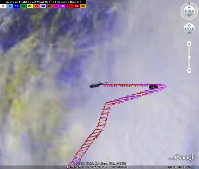
cycloneye

- Admin

- Posts: 149404
- Age: 69
- Joined: Thu Oct 10, 2002 10:54 am
- Location: San Juan, Puerto Rico
Re: ATL : Invest 92L - Recon Thread
More 50kt flight level winds and at SMFR too.
URNT15 KNHC 252150
AF302 01AAA INVEST HDOB 19 20090825
214030 2444N 06417W 9771 00338 0157 +215 +156 094048 049 044 008 00
214100 2444N 06419W 9768 00338 0156 +215 +155 092046 047 043 009 00
214130 2444N 06422W 9767 00339 0157 +215 +155 097048 050 044 005 00
214200 2444N 06424W 9769 00338 0158 +215 +155 097047 048 043 005 00
214230 2444N 06426W 9766 00339 0157 +217 +155 098048 050 046 004 00
214300 2444N 06428W 9776 00332 0156 +217 +156 099050 054 046 005 00
214330 2444N 06430W 9770 00338 0156 +219 +157 099053 054 048 000 00
214400 2444N 06432W 9769 00342 0158 +217 +157 102051 053 050 001 00
214430 2444N 06435W 9776 00334 0159 +216 +158 102051 053 050 003 00
214500 2444N 06437W 9774 00333 0158 +216 +158 102055 057 049 003 00
214530 2444N 06439W 9770 00337 0158 +215 +158 103056 060 049 003 00
214600 2444N 06441W 9772 00335 0157 +215 +158 102050 052 050 003 00
214630 2444N 06443W 9766 00340 0156 +215 +159 100055 056 050 002 00
214700 2444N 06445W 9771 00336 0156 +215 +159 100053 055 050 004 00
214730 2444N 06448W 9766 00339 0157 +213 +159 100051 053 050 003 00
214800 2444N 06450W 9773 00334 0157 +211 +159 099052 054 049 003 00
214830 2444N 06452W 9761 00344 0156 +210 +158 101047 052 048 007 00
214900 2444N 06454W 9785 00323 0155 +210 +157 097050 053 048 008 00
214930 2444N 06456W 9771 00334 0153 +210 +156 098050 050 048 007 00
215000 2444N 06458W 9768 00335 0153 +210 +154 097049 050 048 005 00
0 likes

Re:
Derek Ortt wrote:this looks like a June GOM developing system, with the close proximity to the UL (seems similar to Arlene 2005), with the Andrew windfield. Somewhat strange
sounds oh so close to what we see now....Erin 1995:
By the 27th, both circulations were generating deep convection a few hundred miles to the northeast of the Leeward Islands. A day later, meteorologists at the NHC Tropical Analysis and Forecast Branch (TAFB, formerly TSAF as in figures) and the NESDIS Synoptic Analysis Branch (SAB) assigned Dvorak technique T-numbers of 1.5 to the trailing cloud cluster. These numbers increased to T-2.5, potentially indicative of a tropical cyclone with 35 knot (tropical storm force) winds by midday on the 30th. In reality, although the cloud pattern was slowly consolidating and surface pressures were falling ahead of the system in the Bahamas, development was retarded by southwesterly vertical wind shear associated with an upper-level low that was moving southwestward at 10-15 knots across Florida. Reconnaissance aircraft data from the U.S. Air Force Reserves (Hurricane Hunters) on the 28th, 29th, and again during midday on the 30th indicated that the system did not have a closed circulation at low levels. Instead it was a very vigorous tropical wave--winds speeds around 40 knots were reported from ships in the northern part of the cloud pattern.
Because of the system's potential for development and its close proximity to the Bahamas and Florida, a special nighttime reconnaissance mission was requested by the NHC and flown by the Hurricane Hunters late on the 30th. The first "vortex message" was transmitted to the NHC shortly after 0100 UTC on the 31st. From that information it is estimated that the system became Tropical Storm Erin at 0000 UTC on the 31st (Fig. 1 [47K GIF], Table 1).
0 likes
-
cycloneye
- Admin
- Posts: 149404
- Age: 69
- Joined: Thu Oct 10, 2002 10:54 am
- Location: San Juan, Puerto Rico
Re: ATL: Invest 92L
the imiage i posted earlier showing the two vorts.. are rotating around a mean center and will eventually consolidate around 67 W and 22 to 23 North...
Plane is in another place.
0 likes


-
MGC

- S2K Supporter
- Posts: 5940
- Joined: Sun Mar 23, 2003 9:05 pm
- Location: Pass Christian MS, or what is left.
Re: ATL: Invest 92L
After staring at the satellite loop for some time, I don't see any evidence of a closed circulation at the surface. I would be surprised if this is upgraded. Maybe tomorrow.....MGC
0 likes
-
cycloneye
- Admin
- Posts: 149404
- Age: 69
- Joined: Thu Oct 10, 2002 10:54 am
- Location: San Juan, Puerto Rico
Re: ATL : Invest 92L - Recon Thread
More 50kt + flight level winds.
URNT15 KNHC 252200
AF302 01AAA INVEST HDOB 20 20090825
215030 2444N 06501W 9772 00332 0153 +212 +153 099049 054 050 005 00
215100 2444N 06503W 9776 00326 0151 +210 +153 099051 054 049 007 00
215130 2444N 06505W 9765 00335 0151 +210 +152 098050 053 051 004 00
215200 2444N 06507W 9770 00329 0150 +210 +152 097049 051 048 004 00
215230 2444N 06509W 9777 00325 0150 +209 +152 098055 058 049 004 00
215300 2444N 06511W 9771 00331 0152 +204 +151 099049 051 049 003 00
215330 2444N 06514W 9772 00325 0150 +204 +150 099052 054 046 004 00
215400 2444N 06516W 9771 00329 0149 +208 +148 099052 053 050 003 00
215430 2444N 06518W 9772 00328 0149 +206 +147 096047 048 044 005 00
215500 2444N 06520W 9769 00326 0147 +206 +147 095050 052 048 003 00
215530 2444N 06522W 9773 00326 0147 +209 +147 095054 055 048 004 00
215600 2444N 06524W 9768 00332 0148 +206 +147 095051 053 048 001 03
215630 2444N 06527W 9771 00328 0148 +207 +148 097051 054 048 004 00
215700 2444N 06529W 9775 00324 0147 +207 +148 097049 052 047 004 00
215730 2444N 06531W 9765 00333 0147 +207 +148 098053 055 050 003 00
215800 2444N 06533W 9768 00328 0146 +204 +147 098056 058 047 006 00
215830 2444N 06535W 9774 00323 0146 +202 +146 097053 053 045 007 00
215900 2444N 06537W 9767 00328 0145 +208 +145 098053 054 046 004 00
215930 2444N 06540W 9765 00329 0145 +210 +145 098051 053 047 004 00
220000 2444N 06542W 9773 00324 0143 +210 +147 096055 056 049 006 00
0 likes
Re: ATL: Invest 92L
Somehow the ULL is convecting in the center. Whether it is drilling down at the same time as the wave is forming is your guess as much as mine.
0 likes
-
jlauderdal
- S2K Supporter
- Posts: 7240
- Joined: Wed May 19, 2004 5:46 am
- Location: NE Fort Lauderdale
- Contact:
Re:
CrazyC83 wrote:Could they find stronger winds and have something almost unheard of - a hurricane-strength wave?
sure, its called a strong thunderstorm
0 likes

Who is online
Users browsing this forum: No registered users and 246 guests