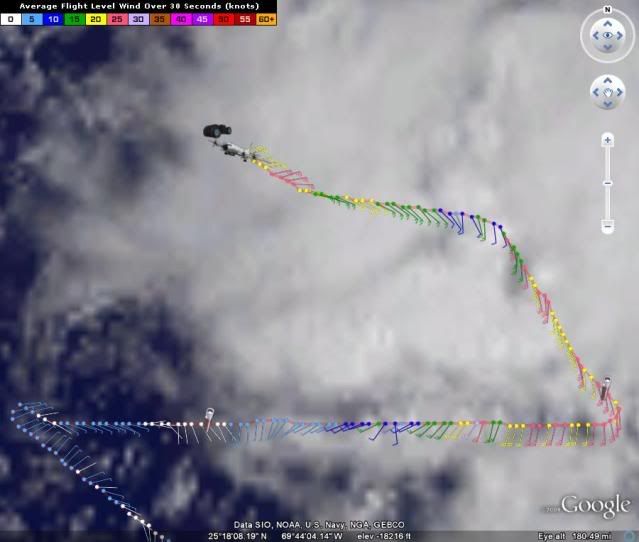
ATL: TROPICAL DEPRESSION DANNY (05L)

Moderator: S2k Moderators

Message
Author
User avatar
SEASON_CANCELED
Category 3
Category 3
Posts: 887
Joined: Mon Jul 06, 2009 5:17 am
Location: 8 Bit Charlie Sheen

Re: ATL: Invest 92L - Computer Models

#981 Postby SEASON_CANCELED » Wed Aug 26, 2009 8:40 am

x-y-no wrote:
SEASON_CANCELED wrote:Yuck the CMC right over manhatten :eek:


Yep .... CMC has the trillion dollar storm scenario - major storm sweeping right up the eastern seaboard from the Grand Banks to Boston.

Let's all sincerely hope that doesn't verify.


A trillion dollars? I would think more than that. 18 million people would be out of work for weeks. Including wall street. Never forget that Manhatten is a shallow island. And all the bridges to it could not withstand a hurricane. The subway would be ruined. Well anyway, lets hope this doesnt pan out. I told the mods they could Ban me if JB was right. After a direct hit on NYC i think it will be like mad max. Total collapse
0 likes   

User avatar
KWT
Category 5
Category 5
Posts: 31415
Joined: Tue Aug 17, 2004 11:02 am
Location: UK!!!

#982 Postby KWT » Wed Aug 26, 2009 8:40 am

I'm not sure I'd go to that extreme Derek, looking at the image's Hurakan has just put up he convection is a lot closer to the LLC then with Alberto.
I do agree though Derek the conditions aren't great but if the ULL keeps diving down and this one keeps slowly lifting out its going to get into better conditions possibly sooner then that, maybe only 24hrs?
0 likes   

User avatar
HURAKAN
Professional-Met
Professional-Met
Posts: 46086
Age: 38
Joined: Thu May 20, 2004 4:34 pm
Location: Key West, FL
Contact:

#983 Postby HURAKAN » Wed Aug 26, 2009 8:43 am

Tropical Storm Danny likely to be named today

First-light satellite images of the tropical wave (92L) a few hundred miles northeast of the Bahama Islands show that the system has developed an organized surface circulation, and 92L will likely be named Tropical Storm Danny later today. This morning's QuikSCAT pass confirms the presence of a surface circulation, and the satellite saw top winds of 50 mph in a cluster of thunderstorms well east of the center. Wind shear has dropped to the moderate range, 10 - 15 knots. The upper-level low 92L is moving underneath has plenty of dry air in it, and the upper low is injecting this dry air into 92L's west side, keeping and heavy thunderstorm activity from developing on that side. The Hurricane Hunters are in 92L, and have found surface winds up to 57 mph so far this morning. NHC continues to give 92L a high (greater than 50% chance) of developing into a tropical depression by Thursday afternoon.

The forecast for 92L
As 92L continues to plow through the upper low, the low will weaken, and wind shear is expected to decline to the low range, 5 - 10 knots, by tonight. However, the upper-level low will continue to dump dry, cold air into 92L through Thursday afternoon, slowing down development. By Thursday night, when 92L should be several hundred miles off the coast of northern Florida, the upper-level low may be weak enough and far enough away that 92L will find itself in a region with light upper level anticyclonic winds, which would favor more rapid development. Most of the intensity models, including the GFDL, HWRF, and SHIPS model, forecast that 92L will become a hurricane by Friday. However, this favorable environment will not last long, since a strong trough of low pressure will be approaching the U.S. East Coast on Friday. This trough will bring high wind shear of 20 - 30 knots by Friday night. This trough should be strong enough to turn 92L to the north. The models have come into better agreement keeping 92L offshore as it passes North Carolina, though the storm is certainly capable of giving the Outer Banks a direct hit. As 92L passes North Carolina, it should start heading north-northeast, with a second landfall likely Saturday night or Sunday morning somewhere between Massachusetts and Nova Scotia. At that time, 92L is likely to be a strong tropical storm or weak Category 1 hurricane, with winds in the 55 - 80 mph range. It currently appears that 92L will not bring tropical storm conditions to the Bahamas or to Florida.


Jeff Masters
0 likes   

CrazyC83
Professional-Met
Professional-Met
Posts: 34002
Joined: Tue Mar 07, 2006 11:57 pm
Location: Deep South, for the first time!

#984 Postby CrazyC83 » Wed Aug 26, 2009 8:43 am

URNT15 KWBC 261337
NOAA3 WXWXA AL92 HDOB 33 20090826
132730 2549N 06924W 6443 03845 0091 +060 +042 080024 025 999 999 03
132800 2550N 06927W 6441 03848 0093 +059 +035 086025 026 999 999 03
132830 2552N 06929W 6440 03849 0095 +058 +035 093026 027 999 999 03
132900 2553N 06931W 6442 03848 0102 +054 +034 102027 028 999 999 03
132930 2554N 06933W 6440 03850 0106 +051 +044 113025 025 999 999 03
133000 2556N 06935W 6441 03849 0108 +050 +042 109026 028 999 999 03
133030 2557N 06937W 6442 03846 0102 +052 +048 105028 029 999 999 03
133100 2558N 06940W 6441 03848 0101 +052 +049 105027 030 999 999 03
133130 2600N 06942W 6440 03851 0094 +057 +057 102016 017 999 999 03
133200 2601N 06944W 6441 03849 0091 +060 +057 102018 020 999 999 03
133230 2602N 06946W 6442 03849 0086 +063 +054 094022 023 999 999 03
133300 2604N 06948W 6442 03849 0085 +064 +049 086023 023 999 999 03
133330 2605N 06951W 6440 03853 0095 +059 +051 074022 023 999 999 03
133400 2606N 06953W 6441 03854 0095 +061 +050 077022 023 999 999 03
133430 2607N 06955W 6441 03854 0092 +064 +042 088021 023 999 999 03
133500 2609N 06957W 6441 03855 0098 +061 +039 097021 022 999 999 03
133530 2610N 06959W 6442 03856 0102 +059 +043 094021 021 999 999 03
133600 2612N 07002W 6441 03856 0103 +058 +046 092020 021 999 999 03
133630 2613N 07004W 6438 03859 0103 +057 +046 090019 020 999 999 03
133700 2614N 07006W 6436 03862 0104 +056 +046 088021 024 999 999 03
0 likes   

User avatar
x-y-no
Category 5
Category 5
Posts: 8359
Age: 65
Joined: Wed Aug 11, 2004 12:14 pm
Location: Fort Lauderdale, FL

#985 Postby x-y-no » Wed Aug 26, 2009 8:43 am

It was just an expression. I wasn't trying to make a serious cost estimate.
0 likes   

User avatar
storms NC
Tropical Storm
Tropical Storm
Posts: 247
Age: 69
Joined: Tue Sep 14, 2004 2:41 pm
Location: Coast of NC & southwest coast of Fla

Re:

#986 Postby storms NC » Wed Aug 26, 2009 8:44 am

HURAKAN wrote:Here he's:

Image

92L:

Image


Looks to be trying to wrap some moisture around it now.
0 likes   

User avatar
SEASON_CANCELED
Category 3
Category 3
Posts: 887
Joined: Mon Jul 06, 2009 5:17 am
Location: 8 Bit Charlie Sheen

Re:

#987 Postby SEASON_CANCELED » Wed Aug 26, 2009 8:45 am

x-y-no wrote:It was just an expression. I wasn't trying to make a serious cost estimate.


Ya i know but reality set it in for a moment. If a direct hit took place it would be EXTREMELY costly if not bring about complete recession
0 likes   

User avatar
KWT
Category 5
Category 5
Posts: 31415
Joined: Tue Aug 17, 2004 11:02 am
Location: UK!!!

Re: ATL: Invest 92L

#988 Postby KWT » Wed Aug 26, 2009 8:46 am

Bocadude85 wrote:http://www.ssd.noaa.gov/goes/flt/t1/loop-vis.html

Great loop here showing the LLC very well... also seems its heading just North of due West


Yeah it doesn't seem to be picking up much latitude though obviously need to watch it over a longer term, it does seem like a north of west motion is occuring right now.
0 likes   

User avatar
HURAKAN
Professional-Met
Professional-Met
Posts: 46086
Age: 38
Joined: Thu May 20, 2004 4:34 pm
Location: Key West, FL
Contact:

#989 Postby HURAKAN » Wed Aug 26, 2009 8:46 am

Image

Leaving now. 'til later
0 likes   

User avatar
ronjon
Category 5
Category 5
Posts: 4822
Joined: Fri Aug 19, 2005 5:17 pm
Location: Hernando Beach, FL

Re: ATL: Invest 92L

#990 Postby ronjon » Wed Aug 26, 2009 8:51 am

I computed the distance to WPB (26.5N-80W) as 616 miles from 92Ls current position. At its current speed (15 mph), it'll take 41 hours to reach it. I think its got about 36 hrs before it turns north with the trough lifting out from the GOM.
0 likes   

User avatar
Thunder44
Category 5
Category 5
Posts: 5922
Age: 44
Joined: Mon Jun 09, 2003 7:53 pm
Location: New York City

Re: ATL : Invest 92L - Recon Thread

#991 Postby Thunder44 » Wed Aug 26, 2009 8:53 am

This must be an errror? Drosponde shows 981mb pressure? 37 kt winds at the surface as well:


Product: NOAA Temp Drop (Dropsonde) Message (UZNT13 KWBC)
Transmitted: 26th day of the month at 13:29Z
Aircraft: Lockheed WP-3D Orion (Reg. Num. N43RF)
Mission: Non-Tasked Mission, possibly not tropical (in the North Atlantic basin)
Mission Identifier: Al92 (Probably storm name and mission number)
Observation Number: 13

Part A...


Date: Near the closest hour of 13Z on the 26th day of the month
Highest Mandatory Level For Which Wind Was Reported: 700mb
Coordinates: 24.6N 67.5W
Map this location: http://www.hhrecon.com/recon/scripts/pa ... &lon=-67.5
Location: 438 miles (705 km) between the NNW and N (348°) from San Juan, Puerto Rico (USA).

Level: Geo. Height / Air Temp. / Dew Point / Wind Direction / Wind Speed
981mb (28.97 inHg): Sea Level (Surface) / 24.6°C (76.3°F) / Approximately 20°C (68°F) / 185° (from the S) / 37 knots (43 mph)
1000mb: -166m (-545 ft) / Other data not available.
925mb: 517m (1,696 ft) / 20.6°C (69.1°F) / 19.2°C (66.6°F) / 170° (from the S) / 30 knots (35 mph)
850mb: 1,245m (4,085 ft) / 17.4°C (63.3°F) / 14.7°C (58.5°F) / 165° (from the SSE) / 34 knots (39 mph)
700mb: 2,878m (9,442 ft) / 7.8°C (46.0°F) / 7.0°C (44.6°F) / 165° (from the SSE) / 32 knots (37 mph)

Information About Radiosonde:
- Launch Time: 12:57Z

Remarks Section...


Release Location: 24.61N 67.46W
Map this location: http://www.hhrecon.com/recon/scripts/pa ... lon=-67.46
Release Time: 12:57:33Z

Splash Location: 24.65N 67.48W
Map this location: http://www.hhrecon.com/recon/scripts/pa ... lon=-67.48
Splash Time: 13:02:06Z

Mean Boundary Level Wind (mean wind in the lowest 500 geopotential meters):
- Wind: 180° (from the S) at 34 knots (39 mph)

Deep Layer Mean Wind (average wind over the depth):
- Wind: 165° (from the SSE) at 32 knots (37 mph)
- Depth of Sounding: From 645mb to 981mb

Average Wind Over Lowest Available 150 geopotential meters (gpm):
- Lowest 150m: 160 gpm - 10 gpm (525 geo. feet - 33 geo. feet)
- Wind: 180° (from the S) at 36 knots (41 mph)


Part B: Data For Significant Levels...


Significant Temperature And Relative Humidity Levels...


Level: Air Temp. / Dew Point
981mb (Surface): 24.6°C (76.3°F) / Approximately 20°C (68°F)
980mb: 24.6°C (76.3°F) / Approximately 20°C (68°F)
903mb: 18.8°C (65.8°F) / 18.4°C (65.1°F)
856mb: 17.6°C (63.7°F) / 14.9°C (58.8°F)
667mb: 5.6°C (42.1°F) / 5.3°C (41.5°F)
644mb: 4.8°C (40.6°F) / 4.8°C (40.6°F)


Significant Wind Levels...


Level: Wind Direction / Wind Speed
981mb (Surface): 185° (from the S) / 37 knots (43 mph)
960mb: 180° (from the S) / 37 knots (43 mph)
933mb: 170° (from the S) / 29 knots (33 mph)
644mb: 160° (from the SSE) / 26 knots (30 mph)


---

Original Undecoded Observation:


UZNT13 KWBC 261329
XXAA 76137 99246 70675 07947 99981 24650 18537 00666 ///// /////
92517 20614 17030 85245 17427 16534 70878 07808 16532 88999 77999
31313 09608 81257
61616 NOAA3 WXWXA AL92 OB 13
62626 REL 2461N06746W 125733 SPG 2465N06748W 130206 WL150 18036 0
85 DLM WND 16532 981645 MBL WND 18034=
XXBB 76138 99246 70675 07947 00981 24650 11980 24650 22903 18804
33856 17627 44667 05603 55644 048//
21212 00981 18537 11960 18037 22933 17029 33644 16026
31313 09608 81257
61616 NOAA3 WXWXA AL92 OB 13
62626 REL 2461N06746W 125733 SPG 2465N06748W 130206 WL150 18036 0
85 DLM WND 16532 981645 MBL WND 18034=
Last edited by Thunder44 on Wed Aug 26, 2009 8:55 am, edited 1 time in total.
0 likes   

CrazyC83
Professional-Met
Professional-Met
Posts: 34002
Joined: Tue Mar 07, 2006 11:57 pm
Location: Deep South, for the first time!

#992 Postby CrazyC83 » Wed Aug 26, 2009 8:53 am

URNT15 KWBC 261347
NOAA3 WXWXA AL92 HDOB 34 20090826
133730 2616N 07008W 6437 03860 0103 +057 +040 088020 021 999 999 03
133800 2617N 07010W 6438 03860 0106 +056 +041 088021 021 999 999 03
133830 2618N 07013W 6439 03860 0103 +058 +038 086022 022 999 999 03
133900 2620N 07015W 6438 03862 0102 +060 +034 087021 022 999 999 03
133930 2621N 07017W 6439 03861 0102 +062 +031 086021 022 999 999 03
134000 2623N 07019W 6439 03861 0106 +060 +028 086021 022 999 999 03
134030 2624N 07021W 6435 03867 0107 +059 +024 087019 020 999 999 03
134100 2626N 07023W 6439 03860 0102 +060 +037 087028 031 999 999 03
134130 2627N 07025W 6439 03861 0105 +057 +051 084030 033 999 999 03
134200 2628N 07028W 6439 03861 0098 +064 +035 084022 023 999 999 03
134230 2630N 07030W 6438 03863 0098 +064 +031 087022 022 999 999 03
134300 2630N 07032W 6437 03866 0102 +062 +034 088024 025 999 999 03
134330 2629N 07035W 6434 03867 0105 +059 +035 084023 024 999 999 03
134400 2629N 07038W 6436 03865 0103 +061 +029 076023 023 999 999 03
134430 2629N 07040W 6437 03864 0101 +062 +024 071023 023 999 999 03
134500 2629N 07043W 6435 03867 0101 +062 +024 071024 024 999 999 03
134530 2628N 07046W 6435 03869 0105 +061 +021 073024 025 999 999 03
134600 2628N 07048W 6435 03869 0106 +061 +022 074026 026 999 999 03
134630 2628N 07051W 6434 03871 0107 +060 +023 074025 026 999 999 03
134700 2627N 07054W 6435 03870 0109 +060 +024 075026 027 999 999 03
0 likes   

CrazyC83
Professional-Met
Professional-Met
Posts: 34002
Joined: Tue Mar 07, 2006 11:57 pm
Location: Deep South, for the first time!

#993 Postby CrazyC83 » Wed Aug 26, 2009 8:53 am

That has to be an error.
0 likes   

User avatar
KWT
Category 5
Category 5
Posts: 31415
Joined: Tue Aug 17, 2004 11:02 am
Location: UK!!!

#994 Postby KWT » Wed Aug 26, 2009 8:54 am

So it could end up being fairly close then Ronjon if the models are right. Will be interesting to see just how much northerly latitude it does gain over the next 12hrs. I'd guess its on roughly a 280 degree motion right now.
0 likes   

otowntiger
Category 5
Category 5
Posts: 1921
Joined: Tue Aug 31, 2004 7:06 pm

Re: ATL: Invest 92L

#995 Postby otowntiger » Wed Aug 26, 2009 8:55 am

I have to say that I'm a little embarrassed for spending so much time watching this thing spit and sputter the last couple of days. :oops: Not only will it clearly not affect my area its probably not even going to be much of threat to anybody, regardless of track due to poor organization and resulting low intensity. I need to move on and get a life! :lol:
0 likes   

User avatar
wxman57
Moderator-Pro Met
Moderator-Pro Met
Posts: 22979
Age: 67
Joined: Sat Jun 21, 2003 8:06 pm
Location: Houston, TX (southwest)

Re: ATL: Invest 92L

#996 Postby wxman57 » Wed Aug 26, 2009 8:56 am

ronjon wrote:I computed the distance to WPB (26.5N-80W) as 616 miles from 92Ls current position. At its current speed (15 mph), it'll take 41 hours to reach it. I think its got about 36 hrs before it turns north with the trough lifting out from the GOM.


I see absolutely nothing to indicate a Florida threat at this time. The main question I have is whether it'll make a significant impact on the NC coast or pass offshore.
0 likes   

Sanibel
Category 5
Category 5
Posts: 10375
Joined: Mon Aug 30, 2004 11:06 pm
Location: Offshore SW Florida

Re: ATL: Invest 92L

#997 Postby Sanibel » Wed Aug 26, 2009 8:56 am

The models blew the track. Good example of how a ULL overhead can keep a storm's outflow from organizing correctly. Naked Danny. System has energy because it is able to develop even with a ULL overhead.
0 likes   

CrazyC83
Professional-Met
Professional-Met
Posts: 34002
Joined: Tue Mar 07, 2006 11:57 pm
Location: Deep South, for the first time!

#998 Postby CrazyC83 » Wed Aug 26, 2009 9:03 am

URNT15 KWBC 261357
NOAA3 WXWXA AL92 HDOB 35 20090826
134730 2627N 07057W 6435 03872 0108 +062 +022 071024 026 999 999 03
134800 2627N 07059W 6434 03872 0109 +062 +010 067022 023 999 999 03
134830 2627N 07102W 6437 03869 0105 +066 -008 064022 022 999 999 03
134900 2626N 07105W 6434 03872 0104 +067 -007 063022 022 999 999 03
134930 2626N 07108W 6436 03870 0100 +069 -011 063021 021 999 999 03
135000 2625N 07110W 6436 03869 0095 +072 -017 060021 022 999 999 03
135030 2625N 07113W 6435 03869 0093 +073 -018 060021 021 999 999 03
135100 2624N 07115W 6435 03870 0094 +072 -015 061021 022 999 999 03
135130 2624N 07118W 6433 03873 0094 +073 -012 058021 022 999 999 03
135200 2623N 07121W 6435 03871 0090 +075 -005 056022 022 999 999 03
135230 2623N 07123W 6435 03871 0091 +074 -004 055023 023 999 999 03
135300 2622N 07126W 6435 03871 0092 +073 -001 056022 023 999 999 03
135330 2622N 07129W 6435 03872 0093 +073 +000 057023 024 999 999 03
135400 2621N 07131W 6435 03873 0095 +071 +008 061023 024 999 999 03
135430 2621N 07134W 6437 03871 0099 +068 +022 073026 028 999 999 03
135500 2620N 07137W 6425 03886 0100 +065 +038 070029 029 999 999 03
135530 2620N 07139W 6429 03879 0096 +068 +032 068028 030 999 999 03
135600 2619N 07142W 6429 03881 0099 +066 +028 066029 030 999 999 03
135630 2619N 07145W 6429 03880 0106 +061 +046 069028 029 999 999 03
135700 2618N 07147W 6434 03876 0113 +058 +042 063027 028 999 999 03
0 likes   

User avatar
KWT
Category 5
Category 5
Posts: 31415
Joined: Tue Aug 17, 2004 11:02 am
Location: UK!!!

Re: ATL: Invest 92L

#999 Postby KWT » Wed Aug 26, 2009 9:04 am

wxman57 wrote:
ronjon wrote:I computed the distance to WPB (26.5N-80W) as 616 miles from 92Ls current position. At its current speed (15 mph), it'll take 41 hours to reach it. I think its got about 36 hrs before it turns north with the trough lifting out from the GOM.


I see absolutely nothing to indicate a Florida threat at this time. The main question I have is whether it'll make a significant impact on the NC coast or pass offshore.


Whats interesting though is this system does seem to be tracking a little further to the west then the models were expecting, most models have this going NW right from the off but it seems more like a 280-285 track to me.
0 likes   

Derek Ortt

#1000 Postby Derek Ortt » Wed Aug 26, 2009 9:06 am

looks stationary on 1km visible
0 likes   


Return to “2009”

Who is online

Users browsing this forum: No registered users and 4 guests