ATL: TROPICAL DEPRESSION DANNY (05L)

Moderator: S2k Moderators

Message
Author
User avatar
artist
Category 5
Category 5
Posts: 9792
Joined: Mon Jun 06, 2005 3:26 pm
Location: West Palm

Re: Re:

#1721 Postby artist » Thu Aug 27, 2009 12:59 pm

tolakram wrote:
artist wrote:ok, when I do a 10 image loop now by clicking on Latitude= 28.23° N Longitude= 72.44° W (X=378 Y=132)
from http://weather.msfc.nasa.gov/GOES/goeseasthurr.html
I am now seeing clouds moving beneath this swirl off to the ne, not in tandem. Is anyone else seeing this? Do a rapid loop and tell me if I am losing it or not please. :ggreen:


YES, for hours now. :p

And for the first poster who must live on the east coast.

http://rammb.cira.colostate.edu/ramsdis ... _floater_1

Put your finger on the LLC and tell me if it's moved. :)


I am feeling soooo confused! lol :lol:
0 likes   

Derek Ortt

#1722 Postby Derek Ortt » Thu Aug 27, 2009 12:59 pm

looks like Danny has weakened a little. Winds according to recon are closer to 40KT
0 likes   

User avatar
artist
Category 5
Category 5
Posts: 9792
Joined: Mon Jun 06, 2005 3:26 pm
Location: West Palm

#1723 Postby artist » Thu Aug 27, 2009 1:00 pm

000
URNT15 KNHC 271753
AF307 0505A DANNY HDOB 30 20090827
174400 2655N 07301W 9664 00379 0090 +245 +194 228016 017 019 000 00
174430 2657N 07302W 9664 00378 0089 +240 +195 229017 018 016 001 00
174500 2658N 07304W 9665 00378 0089 +240 +195 226017 017 020 000 00
174530 2659N 07305W 9662 00380 0088 +240 +196 225017 017 018 001 00
174600 2700N 07306W 9663 00377 0087 +245 +195 227016 017 020 000 00
174630 2701N 07307W 9666 00374 0086 +244 +195 229016 017 020 000 00
174700 2702N 07309W 9662 00377 0086 +240 +196 226015 016 021 000 03
174730 2703N 07310W 9664 00375 0086 +240 +196 224013 014 019 000 00
174800 2704N 07311W 9664 00374 0085 +240 +195 221012 012 020 000 00
174830 2705N 07312W 9663 00375 0085 +240 +196 219011 012 017 000 03
174900 2706N 07314W 9664 00374 0084 +240 +196 221009 010 015 000 03
174930 2707N 07315W 9667 00370 0083 +240 +196 227008 009 013 000 00
175000 2708N 07316W 9665 00371 0082 +240 +196 231008 009 014 000 00
175030 2709N 07317W 9664 00372 0082 +240 +196 235008 008 012 000 03
175100 2711N 07319W 9664 00372 0081 +240 +196 249006 007 013 000 00
175130 2712N 07320W 9664 00371 0081 +240 +196 260005 006 015 000 03
175200 2713N 07320W 9663 00371 0080 +240 +196 262004 004 008 000 00
175230 2715N 07321W 9664 00370 0080 +240 +196 289002 003 009 000 00
175300 2716N 07322W 9662 00372 0079 +240 +196 030002 003 009 000 03
175330 2717N 07323W 9664 00368 0079 +240 +196 040005 006 010 000 00
$$


At 17:44:00Z (first observation), the observation was 298 miles (479 km) to the ENE (65°) from Nassau, Bahamas.
At 17:53:30Z (last observation), the observation was 289 miles (466 km) to the ENE (58°) from Nassau, Bahamas.
0 likes   

tolakram
Admin
Admin
Posts: 20009
Age: 62
Joined: Sun Aug 27, 2006 8:23 pm
Location: Florence, KY (name is Mark)

Re: ATL: TROPICAL STORM DANNY

#1724 Postby tolakram » Thu Aug 27, 2009 1:01 pm

Image

The LLC is looking better, so now I have no clue.

Loop: turn off all but the last few frames.

http://rammb.cira.colostate.edu/ramsdis ... is_floater

This loop is moving toward the NW, but the LLC appears to be moving SE because it's almost stationary.

If you ignore what everyone is calling the LLC and step back to see the big picture:

http://rammb.cira.colostate.edu/ramsdis ... 4km_visir2

I'm hard pressed to see any significant movement. Yea, maybe a swirl of low level clouds makes it to the east coast, but the main convection isn't budging.
0 likes   

User avatar
BensonTCwatcher
Category 5
Category 5
Posts: 1046
Joined: Sat Aug 28, 2004 10:11 pm
Location: Southport NC

#1725 Postby BensonTCwatcher » Thu Aug 27, 2009 1:01 pm

Looking at the GFS it has a brush with OBX which I think it plausible the ridge is building in and the pattern looks very plausible for this to shift the track west. Expect the usual increments for consistency. Of course no good handle on ULL's anywhere...
0 likes   

User avatar
artist
Category 5
Category 5
Posts: 9792
Joined: Mon Jun 06, 2005 3:26 pm
Location: West Palm

#1726 Postby artist » Thu Aug 27, 2009 1:06 pm

000
URNT15 KNHC 271803
AF307 0505A DANNY HDOB 31 20090827
175400 2719N 07324W 9664 00368 0079 +240 +196 047006 007 013 000 00
175430 2720N 07325W 9664 00370 0079 +240 +196 054009 010 011 000 03
175500 2721N 07326W 9665 00370 0080 +240 +196 053011 012 013 000 00
175530 2722N 07327W 9664 00371 0081 +239 +196 050013 014 014 000 00
175600 2723N 07328W 9666 00371 0082 +238 +196 048015 016 013 001 00
175630 2724N 07330W 9663 00373 0083 +236 +196 052017 018 021 000 00
175700 2726N 07331W 9667 00369 0084 +238 +196 051021 022 021 000 00
175730 2727N 07332W 9664 00373 0084 +240 +196 054021 022 022 000 00
175800 2728N 07334W 9666 00373 0085 +239 +195 056023 024 023 000 00
175830 2729N 07335W 9666 00373 0087 +238 +195 059024 024 022 000 03
175900 2730N 07336W 9663 00378 0088 +235 +195 059023 024 021 000 00
175930 2731N 07337W 9662 00380 0089 +235 +195 059023 024 021 000 00
180000 2732N 07339W 9664 00379 0091 +235 +195 059024 024 023 000 00
180030 2733N 07340W 9664 00380 0092 +236 +195 058026 027 024 000 03
180100 2734N 07341W 9663 00382 0093 +235 +195 059024 026 022 001 00
180130 2736N 07343W 9664 00380 0093 +237 +195 057025 026 019 001 00
180200 2737N 07344W 9662 00384 0094 +236 +195 059022 024 017 001 00
180230 2738N 07345W 9666 00381 0094 +240 +195 061024 026 023 000 00
180300 2739N 07346W 9663 00383 0095 +237 +195 061026 027 025 000 00
180330 2740N 07348W 9666 00382 0096 +239 +195 063026 027 025 000 00
$$


At 17:54:00Z (first observation), the observation was 290 miles (466 km) to the ENE (58°) from Nassau, Bahamas.
At 18:03:30Z (last observation), the observation was 284 miles (456 km) to the NE (51°) from Nassau, Bahamas.
0 likes   

User avatar
HURAKAN
Professional-Met
Professional-Met
Posts: 46086
Age: 38
Joined: Thu May 20, 2004 4:34 pm
Location: Key West, FL
Contact:

#1727 Postby HURAKAN » Thu Aug 27, 2009 1:07 pm

Image
0 likes   

meandthestorm
Tropical Wave
Tropical Wave
Posts: 3
Joined: Thu Aug 20, 2009 11:33 pm

Re: ATL: TROPICAL STORM DANNY

#1728 Postby meandthestorm » Thu Aug 27, 2009 1:10 pm

I have a question; I live on the east coast of VA, and our weather dude is not saying much, its like hes scared to. Everyother word is MAYBE this and MAYBE that...Can someone please give me an idea if this cloud that they are calling a storm is coming to VA, and what we could get out of it if anything?
0 likes   

Derek Ortt

#1729 Postby Derek Ortt » Thu Aug 27, 2009 1:12 pm

even if it were to make it to Virginia, you'd still not get much. Everything is east of the center

this thing is not even looking like a tropical cyclone. It is starting to look like a squall line
0 likes   

User avatar
vacanechaser
Category 5
Category 5
Posts: 1461
Joined: Wed Dec 03, 2003 9:34 pm
Location: Portsmouth, Va
Contact:

Re:

#1730 Postby vacanechaser » Thu Aug 27, 2009 1:14 pm

Derek Ortt wrote:even if it were to make it to Virginia, you'd still not get much. Everything is east of the center

this thing is not even looking like a tropical cyclone. It is starting to look like a squall line


yeah, but it would not take it long or not take much for it to wrap around the center... we have seen that happen in the past.. not saying that this will do that, but we know how quickly things can change with these systems..


Jesse V. Bass III
http://www.vastormphoto.com
Hurricane Intercept Research Team
0 likes   

User avatar
artist
Category 5
Category 5
Posts: 9792
Joined: Mon Jun 06, 2005 3:26 pm
Location: West Palm

#1731 Postby artist » Thu Aug 27, 2009 1:17 pm

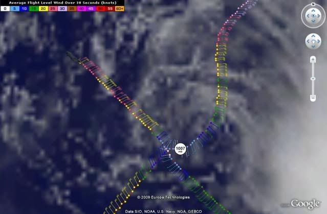
Atlantic USAF High-Density Observations
--------------------------------------------------------------------------------


000
URNT15 KNHC 271813
AF307 0505A DANNY HDOB 32 20090827
180400 2741N 07349W 9666 00383 0096 +239 +193 064024 025 026 003 00
180430 2742N 07350W 9664 00385 0097 +239 +192 060028 029 027 000 00
180500 2743N 07352W 9658 00392 0099 +237 +191 059027 027 023 001 00
180530 2745N 07353W 9668 00383 0099 +240 +191 058026 026 022 000 00
180600 2746N 07354W 9666 00385 0099 +240 +192 060025 026 024 000 00
180630 2747N 07356W 9665 00387 0100 +239 +192 059024 024 023 000 00
180700 2748N 07357W 9664 00388 0101 +239 +193 060024 025 021 000 00
180730 2749N 07358W 9663 00390 0101 +238 +194 062024 025 023 000 00
180800 2750N 07359W 9665 00389 0102 +236 +194 062024 025 024 000 00
180830 2751N 07401W 9667 00388 0103 +237 +195 060024 025 022 000 00
180900 2752N 07402W 9662 00393 0103 +238 +195 059024 025 024 000 00
180930 2753N 07403W 9665 00391 0104 +239 +194 060025 026 024 000 00
181000 2755N 07405W 9667 00390 0104 +240 +194 061026 027 026 000 00
181030 2756N 07406W 9664 00391 0104 +238 +195 059026 026 024 000 00
181100 2757N 07407W 9665 00391 0104 +238 +195 060025 027 024 000 03
181130 2758N 07409W 9666 00390 0105 +239 +195 061025 026 024 000 00
181200 2759N 07410W 9665 00391 0105 +239 +195 062026 026 025 000 03
181230 2800N 07411W 9663 00394 0105 +239 +195 063025 026 024 000 03
181300 2801N 07413W 9662 00394 0106 +238 +196 062024 025 024 000 03
181330 2802N 07414W 9665 00393 0106 +239 +196 062025 025 024 000 00
$$


At 18:04:00Z (first observation), the observation was 284 miles (456 km) to the NE (50°) from Nassau, Bahamas.
At 18:13:30Z (last observation), the observation was 281 miles (452 km) to the NE (43°) from Nassau, Bahamas.
0 likes   

User avatar
HURAKAN
Professional-Met
Professional-Met
Posts: 46086
Age: 38
Joined: Thu May 20, 2004 4:34 pm
Location: Key West, FL
Contact:

#1732 Postby HURAKAN » Thu Aug 27, 2009 1:20 pm

Image
0 likes   

User avatar
BensonTCwatcher
Category 5
Category 5
Posts: 1046
Joined: Sat Aug 28, 2004 10:11 pm
Location: Southport NC

#1733 Postby BensonTCwatcher » Thu Aug 27, 2009 1:22 pm

I can see evidence that anticyclone forecast over Danny is shaping up. So strengthening should begin tonight. We'll see how much really occurs, but and OBX hybrid storm looks like a reasonable call.
0 likes   

User avatar
Duddy
Category 1
Category 1
Posts: 363
Joined: Sat Jun 10, 2006 9:07 pm
Location: Wilmington, NC

Re: ATL: TROPICAL STORM DANNY

#1734 Postby Duddy » Thu Aug 27, 2009 1:22 pm

OK, I had to log in to post this.

What the hell is going on with this thing? It's missing all the tropical points and it looks to me like the LLC is naked and moving West or even WSW.
0 likes   

canes04
Category 1
Category 1
Posts: 302
Joined: Sat May 22, 2004 5:41 pm
Location: Miami, FL

Re: ATL: TROPICAL STORM DANNY

#1735 Postby canes04 » Thu Aug 27, 2009 1:22 pm

It has come to a halt, didn't a model a few days ago have this stalling for a day or two.

If it hangs around long enough who knows what could happen.
The NHC does not have a handle on this one.
0 likes   

poof121
Category 1
Category 1
Posts: 316
Age: 44
Joined: Tue Sep 11, 2007 11:33 am
Location: Laurel, MD

Re: ATL: TROPICAL STORM DANNY

#1736 Postby poof121 » Thu Aug 27, 2009 1:25 pm

Interesting... NHC moved the points on the floater...
0 likes   

User avatar
artist
Category 5
Category 5
Posts: 9792
Joined: Mon Jun 06, 2005 3:26 pm
Location: West Palm

#1737 Postby artist » Thu Aug 27, 2009 1:27 pm

000
URNT15 KNHC 271823
AF307 0505A DANNY HDOB 33 20090827
181400 2804N 07415W 9663 00395 0106 +239 +196 064025 026 022 000 00
181430 2805N 07417W 9664 00395 0107 +236 +196 063024 025 022 002 00
181500 2806N 07418W 9665 00393 0108 +236 +196 064025 026 025 000 00
181530 2807N 07419W 9664 00394 0108 +235 +196 066025 026 023 000 00
181600 2808N 07420W 9666 00394 0108 +237 +196 066026 027 018 002 00
181630 2809N 07422W 9660 00400 0109 +235 +196 064025 027 021 001 00
181700 2810N 07423W 9663 00396 0109 +235 +196 064025 026 023 000 00
181730 2811N 07424W 9665 00395 0110 +235 +196 066025 025 023 000 00
181800 2813N 07426W 9663 00397 0110 +237 +196 066026 027 024 000 00
181830 2814N 07427W 9664 00396 0110 +237 +196 067025 027 023 000 00
181900 2815N 07428W 9664 00397 0111 +235 +197 066026 027 023 000 00
181930 2816N 07430W 9666 00396 0111 +235 +197 067026 027 021 000 00
182000 2817N 07431W 9662 00399 0111 +235 +197 066026 027 023 000 03
182030 2818N 07432W 9663 00399 0111 +235 +197 066027 028 022 000 00
182100 2819N 07434W 9665 00397 0112 +237 +197 065028 029 022 000 00
182130 2820N 07435W 9664 00398 0113 +236 +197 065028 029 023 001 00
182200 2822N 07436W 9667 00397 0113 +238 +196 065028 029 024 000 00
182230 2823N 07438W 9664 00399 0113 +237 +196 067028 029 026 000 00
182300 2824N 07439W 9665 00399 0114 +239 +196 068028 029 026 000 00
182330 2825N 07441W 9664 00399 0115 +239 +196 068029 029 022 005 03
$$


At 18:14:00Z (first observation), the observation was 282 miles (454 km) to the NE (43°) from Nassau, Bahamas.
At 18:23:30Z (last observation), the observation was 284 miles (457 km) to the NE (35°) from Nassau, Bahamas.
0 likes   

User avatar
AdamFirst
S2K Supporter
S2K Supporter
Posts: 2491
Age: 36
Joined: Thu Aug 14, 2008 10:54 am
Location: Port Saint Lucie, FL

Re: ATL: TROPICAL STORM DANNY

#1738 Postby AdamFirst » Thu Aug 27, 2009 1:27 pm

canes04 wrote:It has come to a halt, didn't a model a few days ago have this stalling for a day or two.

If it hangs around long enough who knows what could happen.
The NHC does not have a handle on this one.


I believe the CMC had this thing stalling out a few days ago, it was one of those vague models.
0 likes   

User avatar
artist
Category 5
Category 5
Posts: 9792
Joined: Mon Jun 06, 2005 3:26 pm
Location: West Palm

Re: ATL: TROPICAL STORM DANNY

#1739 Postby artist » Thu Aug 27, 2009 1:29 pm

poof121 wrote:Interesting... NHC moved the points on the floater...


they do with each advisory, as their track changes. The points are not static. That is my understanding.
8-) Please correct me if I am wrong guys!
0 likes   

Derek Ortt

#1740 Postby Derek Ortt » Thu Aug 27, 2009 1:34 pm

it all depends where the small UL to Danny's north drops

if it drops to the east of Danny, we could see dual outflow channels tomorrow and the CMC solution will verify (at least in terms of intensity)

if it drops over Danny, good night Danny
0 likes   


Return to “2009”

Who is online

Users browsing this forum: No registered users and 7 guests