artist wrote:what does the latest euro show?
Recurves around 75w which is farther west then yesterdays 12z run
Moderator: S2k Moderators


artist wrote:what does the latest euro show?

artist wrote:what does the latest euro show?


Stormcenter wrote:I think you'll be just fine in Baton Rouge.BigB0882 wrote:Well these shifts mean I will definitely be keeping an eye on this one.
Evil Jeremy wrote:Stormcenter wrote:But conditions will only get worse and not better for Erika as she moves westward. IMO
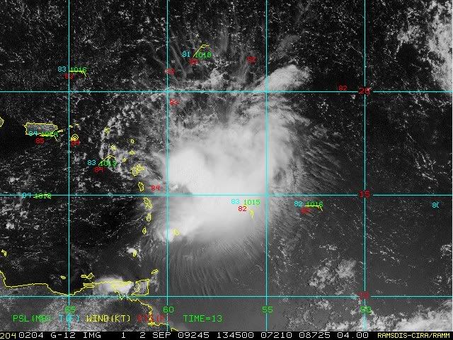
Yea well, 2 nights ago we thought that the shear would obliterate 94L. Conditions keep on changing, so nothing is definite.


Stormcenter wrote:There will be a trough (another one) in the GOM sometime next week that will bring some more nice healthy shear into the area. The funny thing is this thing may not even make that far west to begin with anyway.


lrak wrote:With my amateur satellite skillswhat is pushing this storm further south than planned? The ULL low to her NE?
Track:
We are heading down a complicated nightmare with this one. The system has tracked almost due W if not WSW over night…however this may be more of NHC and the aircraft tracking a vortex around the broad center. Problem with this is that the current vortex being track could dissipate at any time and a new center could form within the deeper convection to the SE…in fact this may be in progress at this time. Until a decent center firms up the track guidance will be only of modest confidence and lend marginal support. The general steering pattern is off toward the WNW for the short term and then complications with the pattern over the western Atlantic on the placement of the sub-tropical ridge and approaching eastern US trough lead to even higher uncertainty.
The tropical models and dynamical consensus and ensembles all are south of the official NHC forecast track. In addition, the global models including the GFS is well S and W of the official track. The HWRF and GFDL tracks are more to the right with the HWRF well to the east of NHC. However these models have been trending westward with time over the past 24 hours and several including the GFDL and HWRF are suggesting a westerly bending toward the end of the forecast period.
For now will go with a slow short term W motion followed by a slight bend toward the WNW as the system becomes somewhat better organized. Forecast confidence after 48 hours is fairly low as based on the current motion… even the 24 hour forecast could be horribly off especially given any center relocations.
Portastorm wrote:Stormcenter wrote:There will be a trough (another one) in the GOM sometime next week that will bring some more nice healthy shear into the area. The funny thing is this thing may not even make that far west to begin with anyway.
There will? Where? I just looked at the 500mb and 850 mb patterns for next week from the last few GFS runs and there is no trough in the Gulf. The 0z run deepens a trough about Sept. 12th other than that ... the pattern is more ridging than anything else.

TreasureIslandFLGal wrote:StormCenter,
I don't like to hear talk of another front coming unless it parks itself off the east coast of Florida. Approaching fronts in the Gulf with storms coming into Florida gives the west coast of Florida its only real threats from things coming in from the south.
i.e. if this cuts across southern Florida, very little impact from land interaction will occur. Heck, storms actually often strengthen over south Florida because of the swamps! Then into the gulf and a recurve because of an approaching front puts a storm into the bend...making the west coast on the NE, messy side of a storm.
At this point, at least for Conus concerns, lets hope the BAMMS play out and send this into Hispanola and a slow death. Although I also don't want to wish any copious amounts of rain on poor Haiti. They had a hell of a year last year as it was!
Maybe shear will just kill this.
I had a dream last night that Erika pulled a Charlie-esque move --into the Gulf and then turned N & NE by a late approaching front. Everyone expected it to go into the panhandle, but it instead went inland at Clearwater, FL pretty abruptly. Would that be dreamcasting vs. -removed-? -that wasn't even the worst of the nightmare though, even though the storm damage/coastal flooding was bad. But the worst part of the dream was that the shelters and local area all went rampant with Swine flu since folks were either crammed close together there or trying to work together to clean up neighborhoods and there wasn't good medical treatment available (overwhelmed hospitals) so many deaths resulted...less by the hurricane and more because of all the untreated flu (untreatable under post-storm conditions)!
I obviously worry about too many things.

vbhoutex wrote:lrak wrote:With my amateur satellite skills
I'm not so sure that she is actually moving SW as opposed to the recon picking up on different vortexes within the broad low level circulation and not necessarily finding the "exact center" of the circulation. This is from Jeff Lindner's email this am:Track:
We are heading down a complicated nightmare with this one. The system has tracked almost due W if not WSW over night…however this may be more of NHC and the aircraft tracking a vortex around the broad center. Problem with this is that the current vortex being track could dissipate at any time and a new center could form within the deeper convection to the SE…in fact this may be in progress at this time. Until a decent center firms up the track guidance will be only of modest confidence and lend marginal support. The general steering pattern is off toward the WNW for the short term and then complications with the pattern over the western Atlantic on the placement of the sub-tropical ridge and approaching eastern US trough lead to even higher uncertainty.
The tropical models and dynamical consensus and ensembles all are south of the official NHC forecast track. In addition, the global models including the GFS is well S and W of the official track. The HWRF and GFDL tracks are more to the right with the HWRF well to the east of NHC. However these models have been trending westward with time over the past 24 hours and several including the GFDL and HWRF are suggesting a westerly bending toward the end of the forecast period.
For now will go with a slow short term W motion followed by a slight bend toward the WNW as the system becomes somewhat better organized. Forecast confidence after 48 hours is fairly low as based on the current motion… even the 24 hour forecast could be horribly off especially given any center relocations.
Users browsing this forum: No registered users and 5 guests