ATL : TROPICAL DEPRESSION ERIKA (06L)

Moderator: S2k Moderators

Message
Author
User avatar
Evil Jeremy
S2K Supporter
S2K Supporter
Posts: 5463
Age: 32
Joined: Mon Apr 10, 2006 2:10 pm
Location: Los Angeles, CA

Re: ATL : TROPICAL STORM ERIKA - Computer Models

#3721 Postby Evil Jeremy » Wed Sep 02, 2009 11:48 pm

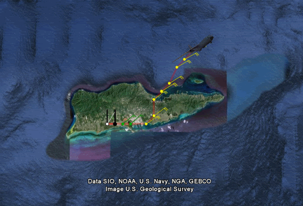
AtlanticWind wrote:I am a little perplexed by the intensity forecsat by the NHC, ships takes the up to 60 mph, HWRF goes crazy , nogaps seems to have a pretty strong system , gfdl has it at 1002 mb before hitting the D.R.. it seems the nhc forcast should at least mantain mid tropical storm strengh until they are sure the circulation is gone.


Well, the models have been really underestimating the shear lately, and the storm was on the edge of dieing earlier tonight, and the upcoming shear, as well as interaction with the mountains of the islands would of killed Erika, but if it is indeed reforming further north, the entire track and intensity forecasts, as Derek so wisely put it, would need to be "chucked".
0 likes   

User avatar
vbhoutex
Storm2k Executive
Storm2k Executive
Posts: 29113
Age: 73
Joined: Wed Oct 09, 2002 11:31 pm
Location: Cypress, TX
Contact:

Re: ATL : TROPICAL STORM ERIKA (06L)

#3722 Postby vbhoutex » Wed Sep 02, 2009 11:53 pm

I could easily be proved wrong in this case, but I don't see what you are seeing. I do see a mlc moving ne away from the northern convection, but I am not picking up on the low level spin you are. I still think that, like I posted several pages ago that we have a completely decoupled system with any low level spin still going w or wsw and the mlc heading ne.
0 likes   

User avatar
deltadog03
Professional-Met
Professional-Met
Posts: 3580
Joined: Tue Jul 05, 2005 6:16 pm
Location: Macon, GA

#3723 Postby deltadog03 » Wed Sep 02, 2009 11:54 pm

Recon should be on the way pretty soon I think...
0 likes   

User avatar
deltadog03
Professional-Met
Professional-Met
Posts: 3580
Joined: Tue Jul 05, 2005 6:16 pm
Location: Macon, GA

#3724 Postby deltadog03 » Wed Sep 02, 2009 11:55 pm

Vb, look at the dark cloud elements just on the line of really deep convection. Its hard to see initially, but speed the loop up and you will see the dark clouds spinning.

In fact, the deep convection is moving over and expanding with that spin. I think what helps me to see it, and could be wrong, but look how the deep convection sticks out around that area and its moving WNW.
0 likes   

User avatar
Evil Jeremy
S2K Supporter
S2K Supporter
Posts: 5463
Age: 32
Joined: Mon Apr 10, 2006 2:10 pm
Location: Los Angeles, CA

#3725 Postby Evil Jeremy » Wed Sep 02, 2009 11:55 pm

This next recon mission will be very important, it will help us know if there is any LLC at all, and if there is one reforming to the north of the old one.
0 likes   

WeatherEmperor
S2K Supporter
S2K Supporter
Posts: 4806
Age: 41
Joined: Thu Sep 04, 2003 2:54 pm
Location: South Florida

Re: ATL : TROPICAL STORM ERIKA - RECON

#3726 Postby WeatherEmperor » Wed Sep 02, 2009 11:55 pm

Delta,

I know this is kind of a weird question to ask, but what do you think the hurricane hunters will find? do you think they will find a new center up north?

<RICKY>
0 likes   

User avatar
Dave
Retired Staff
Retired Staff
Posts: 13442
Age: 74
Joined: Tue Aug 01, 2006 3:57 pm
Location: Milan Indiana
Contact:

Re:

#3727 Postby Dave » Wed Sep 02, 2009 11:55 pm

deltadog03 wrote:Recon should be on the way pretty soon I think...


Waiting now
0 likes   

MWatkins
S2K Supporter
S2K Supporter
Posts: 2574
Joined: Sat Oct 12, 2002 7:51 pm
Location: SE Florida
Contact:

Re: ATL : TROPICAL STORM ERIKA - Computer Models

#3728 Postby MWatkins » Wed Sep 02, 2009 11:56 pm

FWIW NOGAPS is not holding on to much at 24 hours with a very weak 500MB reflection just east of Puerto Rico. At the surface it looks almost like an open trough but still, in theory, hanging in there.

IF there is something at the surface trying to get cooking at 17/61, and after watching the loops over and over again it kind of looks that way, then we could be seeing enough to keep this going for the next couple of days.

Just looked at 36H NOGAPS and it has a closed surface circulation or very sharp surface trough (looks closed through) just north of the DR.

These little hanging in there circulations aren't something to dismiss easily. Not taking my eye off of this one until there's no deep convection left.

MW
0 likes   

User avatar
deltadog03
Professional-Met
Professional-Met
Posts: 3580
Joined: Tue Jul 05, 2005 6:16 pm
Location: Macon, GA

#3729 Postby deltadog03 » Wed Sep 02, 2009 11:58 pm

Rodger that. I am not sure at this point anymore. lol I really do think I see some low level spin there though. I hope they sample that area. I don't see any low level spin anywhere else. I mean, its hard with no true VIS shot, but its descent.
0 likes   

User avatar
Dave
Retired Staff
Retired Staff
Posts: 13442
Age: 74
Joined: Tue Aug 01, 2006 3:57 pm
Location: Milan Indiana
Contact:

#3730 Postby Dave » Wed Sep 02, 2009 11:59 pm

URNT15 KNHC 030457
AF307 0406A ERIKA HDOB 01 20090903
044730 1742N 06448W 0116 00000 0113 +275 +167 360000 000 087 000 20
044800 1742N 06448W 0115 00000 0113 +270 +166 360000 000 087 000 20
044830 1742N 06448W 0115 00000 0113 +270 +165 360000 000 087 000 20
044900 1742N 06448W 0114 00000 0112 +270 +164 360000 000 087 000 20
044930 1742N 06448W 0115 00000 0112 +270 +164 360000 000 087 000 20
045000 1742N 06448W 0114 00000 0112 +270 +163 360000 000 087 000 23
045030 1742N 06448W 0116 00000 0112 +270 +162 360000 000 999 999 23
045100 1742N 06448W 0116 00000 0112 +270 +162 360000 000 999 999 23
045130 1742N 06448W 0114 00000 0111 +270 +161 360000 000 999 999 23
045200 1742N 06448W 0113 00000 0109 +270 +160 360000 000 999 999 23
045230 1742N 06448W 0113 00000 0110 +270 +159 360000 000 999 999 23
045300 1742N 06448W 0113 00000 0110 +270 +159 360000 000 999 999 23
045330 1742N 06448W 0113 00000 0109 +268 +158 360000 000 999 999 23
045400 1742N 06448W 0112 00000 0109 +266 +158 360000 000 999 999 23
045430 1742N 06448W 0110 00000 0107 +266 +157 360000 000 999 999 23
045500 1742N 06448W 0109 00000 0106 +265 +157 360000 000 999 999 23
045530 1742N 06448W 0108 00000 0104 +265 +156 360000 000 999 999 23
045600 1742N 06448W 0106 00000 0103 +265 +156 360000 000 999 999 23
045630 1742N 06448W 0105 00000 0101 +265 +155 360000 000 999 999 23
045700 1742N 06449W 0102 00000 0099 +265 +155 360000 000 999 999 23
$$
;
0 likes   

User avatar
Evil Jeremy
S2K Supporter
S2K Supporter
Posts: 5463
Age: 32
Joined: Mon Apr 10, 2006 2:10 pm
Location: Los Angeles, CA

#3731 Postby Evil Jeremy » Thu Sep 03, 2009 12:00 am

A little off topic, but I was always curious, any of you know how many people are normally on a recon plane during a normal routine like the one coming up?
0 likes   

User avatar
deltadog03
Professional-Met
Professional-Met
Posts: 3580
Joined: Tue Jul 05, 2005 6:16 pm
Location: Macon, GA

#3732 Postby deltadog03 » Thu Sep 03, 2009 12:00 am

I agree fully MW!! I think this one is going to be the little engine that could. Recon should be leaving soon, and I really hope they go up to that area.
0 likes   

User avatar
vbhoutex
Storm2k Executive
Storm2k Executive
Posts: 29113
Age: 73
Joined: Wed Oct 09, 2002 11:31 pm
Location: Cypress, TX
Contact:

Re: ATL : TROPICAL STORM ERIKA (06L)

#3733 Postby vbhoutex » Thu Sep 03, 2009 12:03 am

I can see a possible mini vortex scooting off to the N of the NW side of the convection if I really work on it, but past that I can't come up with anything past what I have already posted. With Erika, who knows? We both could be proved to be out in left field!!
0 likes   

User avatar
Dave
Retired Staff
Retired Staff
Posts: 13442
Age: 74
Joined: Tue Aug 01, 2006 3:57 pm
Location: Milan Indiana
Contact:

#3734 Postby Dave » Thu Sep 03, 2009 12:08 am

URNT15 KNHC 030507
AF307 0406A ERIKA HDOB 02 20090903
045730 1742N 06449W 0100 00000 0097 +265 +154 360000 000 999 999 23
045800 1742N 06449W 0100 00000 0094 +265 +154 360000 000 999 999 23
045830 1742N 06449W 0098 00000 0094 +265 +153 360000 000 999 999 23
045900 1742N 06449W 0097 00000 0093 +265 +152 360000 000 999 999 23
045930 1742N 06449W 0090 00000 0092 +267 +152 360000 000 999 999 23
050000 1742N 06449W 0097 00000 0093 +265 +151 360000 000 999 999 23
050030 1742N 06449W 0096 00000 0092 +265 +150 360000 000 999 999 23
050100 1742N 06449W 0097 00000 0092 +265 +150 360000 000 999 999 23
050130 1742N 06449W 0096 00000 0092 +265 +149 360000 000 999 999 23
050200 1742N 06449W 0104 00000 0101 +265 +150 032004 006 999 999 23
050230 1742N 06447W 9946 00151 0109 +260 +153 050016 018 999 999 03
050300 1742N 06446W 9749 00330 0118 +245 +156 048017 019 999 999 03
050330 1742N 06444W 9330 00699 0097 +219 +157 055021 022 999 999 03
050400 1743N 06443W 8996 00934 0057 +199 +156 054024 026 999 999 03
050430 1745N 06443W 8597 01407 0095 +182 +151 052023 024 999 999 03
050500 1746N 06442W 8462 01565 0127 +175 +146 057021 022 999 999 03
050530 1747N 06441W 8434 01595 0131 +172 +140 058021 022 999 999 03
050600 1749N 06440W 8432 01597 0130 +173 +134 059021 022 999 999 03
050630 1750N 06439W 8428 01601 0130 +172 +129 061021 021 999 999 03
050700 1751N 06438W 8426 01602 0131 +170 +125 058020 021 999 999 03
$$
;

Takeoff
0 likes   

MWatkins
S2K Supporter
S2K Supporter
Posts: 2574
Joined: Sat Oct 12, 2002 7:51 pm
Location: SE Florida
Contact:

Re:

#3735 Postby MWatkins » Thu Sep 03, 2009 12:14 am

deltadog03 wrote:I agree fully MW!! I think this one is going to be the little engine that could. Recon should be leaving soon, and I really hope they go up to that area.


Agreed! Let's see what they find up there!

And again, I know it's NOGAPS, but it still shows a closed surface circulation at 84 hrs hanging out in the Turks.

So far 2 out of 2 global models agree that this isn't going to go quitely into the night tonight. The next couple of days are going to be VERY interesting indeed.

MW
0 likes   

User avatar
Dave
Retired Staff
Retired Staff
Posts: 13442
Age: 74
Joined: Tue Aug 01, 2006 3:57 pm
Location: Milan Indiana
Contact:

#3736 Postby Dave » Thu Sep 03, 2009 12:16 am

Image
0 likes   

User avatar
Dave
Retired Staff
Retired Staff
Posts: 13442
Age: 74
Joined: Tue Aug 01, 2006 3:57 pm
Location: Milan Indiana
Contact:

#3737 Postby Dave » Thu Sep 03, 2009 12:19 am

URNT15 KNHC 030517
AF307 0406A ERIKA HDOB 03 20090903
050730 1752N 06437W 8429 01600 0131 +172 +122 055021 021 999 999 03
050800 1753N 06436W 8428 01601 0131 +171 +119 056019 020 999 999 03
050830 1754N 06435W 8429 01598 0131 +175 +117 057020 020 999 999 03
050900 1755N 06434W 8428 01602 0131 +174 +115 058020 021 999 999 03
050930 1756N 06433W 8429 01601 0131 +173 +114 056021 022 999 999 03
051000 1757N 06431W 8428 01601 0131 +175 +113 055023 023 999 999 03
051030 1758N 06430W 8428 01599 0131 +175 +112 056023 023 999 999 03
051100 1759N 06429W 8425 01603 0129 +175 +111 057022 022 999 999 03
051130 1800N 06428W 8428 01598 0129 +175 +110 056022 023 999 999 03
051200 1800N 06426W 8428 01602 0130 +175 +109 059021 022 999 999 03
051230 1801N 06425W 8428 01601 0130 +175 +109 058022 023 999 999 03
051300 1802N 06424W 8429 01602 0128 +175 +109 059022 023 999 999 03
051330 1803N 06423W 8426 01602 0130 +174 +109 056022 022 999 999 03
051400 1804N 06422W 8428 01601 0131 +175 +109 056022 022 022 001 03
051430 1805N 06420W 8429 01600 0128 +176 +108 057023 024 024 000 00
051500 1806N 06419W 8428 01601 0130 +176 +107 056023 023 024 000 03
051530 1806N 06418W 8422 01611 0134 +176 +108 052023 024 999 999 03
051600 1805N 06417W 8422 01606 0130 +177 +108 050025 025 020 000 03
051630 1803N 06418W 8432 01596 0128 +177 +109 048024 025 024 000 03
051700 1801N 06418W 8428 01600 0128 +175 +109 047024 024 020 000 00
$$
;
0 likes   

MWatkins
S2K Supporter
S2K Supporter
Posts: 2574
Joined: Sat Oct 12, 2002 7:51 pm
Location: SE Florida
Contact:

#3738 Postby MWatkins » Thu Sep 03, 2009 12:23 am

At 180 hrs NOGAPS puts a serious hurricane up near Hattaras.

It's that time of year.

MW
0 likes   

User avatar
hurricanetrack
HurricaneTrack.com
HurricaneTrack.com
Posts: 1781
Joined: Tue Dec 02, 2003 10:46 pm
Location: Wilmington, NC
Contact:

#3739 Postby hurricanetrack » Thu Sep 03, 2009 12:23 am

NewGFDL keeps it for all 126hrs this time.
0 likes   

User avatar
AJC3
Admin
Admin
Posts: 3999
Age: 61
Joined: Tue Aug 31, 2004 7:04 pm
Location: Ballston Spa, New York
Contact:

Re: ATL : TROPICAL STORM ERIKA (06L)

#3740 Postby AJC3 » Thu Sep 03, 2009 12:24 am

Doubt this is a true center "reformation" per se. Based upon sat, recon and scatterometer data from earlier today (refer to the conversation between AFM, Derek, and Chris [wxman57] ), what I think you had going on was two separate vort centers aligned along an w-e or wsw-ene oriented axis. The lead vort shot out way ahead of the convection, became exposed, passed over Guadeloupe and came to screeching halt. You could see this take place on both vis satellie and the mosaic radar loop. What I think then happened is that the vort axis pivoted northward and the trailing vort (which recon fixed as a center while the lead vort was becoming exposed well ahead) tightened up as it turned toward the NW. This is the area where I think you're seeing the convection fire up over the past several hours.

In spite of the refiring, the atmospheric conditions don't look very promising for Erica. Mid-tropospheric shear doesn't look to abate soon enough before SW upper tropospheric shear comes into the picture.

my $ 0.0000002 (the first in some time)

T
0 likes   


Return to “2009”

Who is online

Users browsing this forum: No registered users and 5 guests