Possible NW Gulf Development Late This Week?

This is the general tropical discussion area. Anyone can take their shot at predicting a storms path.

Moderator: S2k Moderators

Forum rules

The posts in this forum are NOT official forecasts and should not be used as such. They are just the opinion of the poster and may or may not be backed by sound meteorological data. They are NOT endorsed by any professional institution or STORM2K. For official information, please refer to products from the National Hurricane Center and National Weather Service.

Help Support Storm2K
Message
Author
User avatar
LaBreeze
Category 5
Category 5
Posts: 1497
Joined: Thu Sep 04, 2003 1:57 pm
Location: SW Louisiana

Re: Possible NW Gulf Development Late This Week?

#421 Postby LaBreeze » Sun Sep 13, 2009 10:51 pm

attallaman wrote:All is quiet here tonight, I did have a few good thunderboomers with lots of lightning this afternoon but they moved through here quick so is the threat of anything developing in the W GOM or the C GOM now gone?


Yes, from what I am hearing from local mets. Nothing left in the W GOM or C GOM to develop tropically.
0 likes   

User avatar
lrak
S2K Supporter
S2K Supporter
Posts: 1770
Age: 58
Joined: Thu Jun 21, 2007 2:48 pm
Location: Corpus Christi, TX

Re:

#422 Postby lrak » Mon Sep 14, 2009 11:10 am

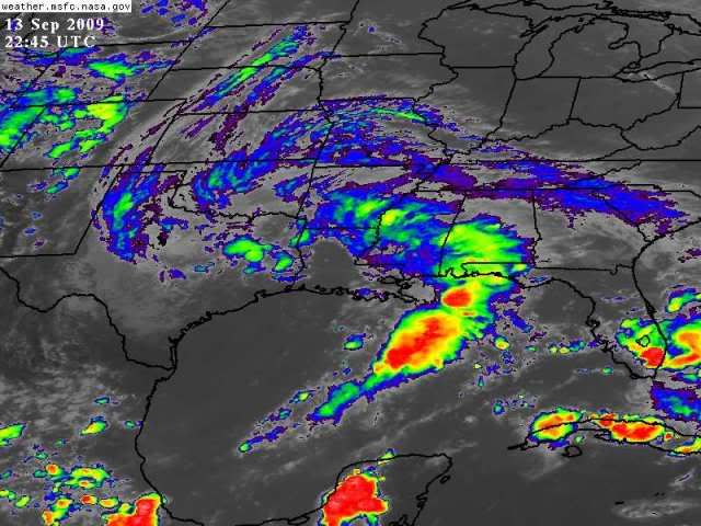
HURAKAN wrote:Image

Not very tropical :lol:


I know you guys want this thread to die, but that looks like a tropical system over land :eek:

Can you imagine if there were good conditions for developement last week and it was in the BOC? :eek: :eek: :eek:
0 likes   

User avatar
HURAKAN
Professional-Met
Professional-Met
Posts: 46086
Age: 38
Joined: Thu May 20, 2004 4:34 pm
Location: Key West, FL
Contact:

Re: Re:

#423 Postby HURAKAN » Mon Sep 14, 2009 11:15 am

lrak wrote:I know you guys want this thread to die, but that looks like a tropical system over land :eek:


Tropical systems don't have cold fronts and their size is usually smaller. What we see in the picture is a classic non-tropical system.
0 likes   

attallaman

Re: Possible NW Gulf Development Late This Week?

#424 Postby attallaman » Mon Sep 14, 2009 2:21 pm

Some of my local TV METs were saying today that what's left of that L will just sit up there where it is now for a few days and give that region soaking rains. Would it be possible for that L to begin tracking back towards the GOM and creating yet another problem if it did re-enter the GOM? Has something like that ever happened?
0 likes   

User avatar
vbhoutex
Storm2k Executive
Storm2k Executive
Posts: 29113
Age: 73
Joined: Wed Oct 09, 2002 11:31 pm
Location: Cypress, TX
Contact:

Re: Possible NW Gulf Development Late This Week?

#425 Postby vbhoutex » Mon Sep 14, 2009 3:33 pm

attallaman wrote:Some of my local TV METs were saying today that what's left of that L will just sit up there where it is now for a few days and give that region soaking rains. Would it be possible for that L to begin tracking back towards the GOM and creating yet another problem if it did re-enter the GOM? Has something like that ever happened?

I believe the ECMWF had it doing just that earlier this week. I believe the last time a low moved inland and looped and headed back into the GOM in this area(SE TX)the name was Allison. I know that was not the only time something like that has happened. Ivan comes to mind in that he went in at Mobile/P'cola and his remnants looped back out over the ATL near NC and made it back into the GOM and landfalled again in SE TX, but was not a major storm at the final landfall.

edit to add for clarity. The ULL is what is still spinning over Texas, not the low that moved out of the GOM into LA and is continuing to move NE.
0 likes   

User avatar
lrak
S2K Supporter
S2K Supporter
Posts: 1770
Age: 58
Joined: Thu Jun 21, 2007 2:48 pm
Location: Corpus Christi, TX

Re: Possible NW Gulf Development Late This Week?

#426 Postby lrak » Tue Sep 15, 2009 8:05 pm

http://forecast.weather.gov/MapClick.ph ... &map.y=265

http://radar.weather.gov/radar.php?rid= ... 11&loop=no

http://radar.weather.gov/radar.php?rid= ... 1&loop=yes

http://radar.weather.gov/radar.php?prod ... K&loop=yes

Spin, west wind, and low pressure...strange. I remember a storm a few years back that stayed looking like a tropical system way inland over TX. They become great SOAKERS...my yard is still muddy!
0 likes   

CYCLONE MIKE
Category 5
Category 5
Posts: 2183
Joined: Tue Aug 31, 2004 6:04 pm
Location: Gonzales, LA

Re: Possible NW Gulf Development Late This Week?

#427 Postby CYCLONE MIKE » Tue Sep 15, 2009 8:32 pm

I think the door is about to slam shut on the GOM season. I know, I know things can change but in my opinion I think the season is just about over. Maybe a storm or two somewhere in the atlantic but with the frequency and strength of fronts sweeping through the gulf states hard to get anything going or have something move in from the east with the southwesterly flow. And of course after the front there is shear screaming through the gulf for a few days after. Then before you know it another front is dropping down. It has been like this for the last month. Here is a piece from our latest AFD...

THERE IS BETTER AGREEMENT MONDAY INTO NEXT WEEK WITH BOTH THE GFS
AND THE ECMWF INDICATING A DEEP MID/UPPER TROUGH SETTING UP OVER
THE WESTERN GREAT LAKES TO MID MISSISSIPPI VALLEY AREA TUESDAY
WITH A STRONGER SYSTEM COMING DOWN INTO THE BASE OF THE TROUGH
LATER NEXT WEEK. THE AMOUNT OF COOL/COLD AIR WITH THIS SYSTEM
LOOKS UNUSUALLY STRONG FOR SEPTEMBER. THE INITIAL FRONTAL BOUNDARY
SHOULD GET A PUSH INTO THE FORECAST AREA ON TUESDAY. HAVE KEPT A
CHANCE OF SHOWERS AND THUNDERSTORMS IN THE FORECAST MONDAY THROUGH
TUESDAY.

So looks like another week without any development.
0 likes   

User avatar
HurricaneBelle
S2K Supporter
S2K Supporter
Posts: 1179
Joined: Sun Aug 27, 2006 6:12 pm
Location: Clearwater, FL

Re: Possible NW Gulf Development Late This Week?

#428 Postby HurricaneBelle » Tue Sep 15, 2009 8:53 pm

CYCLONE MIKE wrote:I think the door is about to slam shut on the GOM season. I know, I know things can change but in my opinion I think the season is just about over. Maybe a storm or two somewhere in the atlantic but with the frequency and strength of fronts sweeping through the gulf states hard to get anything going or have something move in from the east with the southwesterly flow. And of course after the front there is shear screaming through the gulf for a few days after. Then before you know it another front is dropping down. It has been like this for the last month.


Hmmm...I seem to recall last year somebody said something just like this and ended up with Ike for his troubles. :)
0 likes   

User avatar
vbhoutex
Storm2k Executive
Storm2k Executive
Posts: 29113
Age: 73
Joined: Wed Oct 09, 2002 11:31 pm
Location: Cypress, TX
Contact:

Re: Possible NW Gulf Development Late This Week?

#429 Postby vbhoutex » Tue Sep 15, 2009 10:10 pm

CYCLONE MIKE wrote:I think the door is about to slam shut on the GOM season. I know, I know things can change but in my opinion I think the season is just about over. Maybe a storm or two somewhere in the atlantic but with the frequency and strength of fronts sweeping through the gulf states hard to get anything going or have something move in from the east with the southwesterly flow. And of course after the front there is shear screaming through the gulf for a few days after. Then before you know it another front is dropping down. It has been like this for the last month.


If one of these fronts makes it into the GOM, which they will start doing, we will still have the threat of a homegrown(cut-off low)developing. Of course, the shear would have to relax too along with other factors being right for it to develop into a TC. But, as stated above, even with the current pattern and parameters we are seeing, it is still too early to declare the GOM season done imo. I HOPE IT IS DONE THOUGH!!! Last year will last us for many, many years!!
0 likes   

jinftl
Category 5
Category 5
Posts: 4312
Joined: Tue Aug 31, 2004 4:47 pm
Location: fort lauderdale, fl

Re: Possible NW Gulf Development Late This Week?

#430 Postby jinftl » Tue Sep 15, 2009 10:15 pm

Current shear in the Gulf is slightly below climatologic norms...and has significantly dropped in the last week or so

Image
0 likes   

User avatar
Pearl River
S2K Supporter
S2K Supporter
Posts: 825
Age: 66
Joined: Fri Dec 09, 2005 6:07 pm
Location: SELa

Re: Possible NW Gulf Development Late This Week?

#431 Postby Pearl River » Wed Sep 16, 2009 7:56 am

Let's not forget Hilda in 1964: From Wikipedia.

A tropical wave organized into a tropical depression on September 28 while located south of Cuba. It steadily strengthened throughout the day and became a tropical storm on the 29th near the western tip of Cuba. On the 30th, Hilda strengthened to hurricane intensity, which was followed by a period of rapid intensification which lasted until October 1. Hilda became a 150 mph (240 km/h) Category 4 hurricane while south of Louisiana. As it approached the coastline, conditions became unfavorable, weakening Hilda to a 110 mph (180 km/h) Category 2 hurricane at the time of its St. Mary Parish, Louisiana landfall on October 4. After landfall, Hilda quickly dissipated over Georgia. Hurricane Hilda killed 37 when it made landfall in Louisiana, with most of the deaths caused by storm-generated tornadoes. It caused roughly $126 million (1964 dollars ($760 million 2005 dollars)) in damage.
0 likes   

User avatar
wxman57
Moderator-Pro Met
Moderator-Pro Met
Posts: 22979
Age: 67
Joined: Sat Jun 21, 2003 8:06 pm
Location: Houston, TX (southwest)

Re: Possible NW Gulf Development Late This Week?

#432 Postby wxman57 » Wed Sep 16, 2009 8:38 am

jinftl wrote:Current shear in the Gulf is slightly below climatologic norms...and has significantly dropped in the last week or so

http://img7.imageshack.us/img7/4880/sheargulf.png


I wonder how that chart is calculated. Just a quick look at 200mb winds across the Gulf today (in the light wind shear shown on the chart), and I see that north of 25N, the winds are from the west at 30kts to 55kts across the whole northern half to 2/3 of the Gulf.

An encouraging note is the sharp climatological rise in shear that begins across the Gulf in September. With the first significant cold front reaching the Gulf early next week, at least the NW Gulf may be out of the woods for 2009. Can't rule out the chance of a hit in the NE Gulf, Florida and the East U.S. Coast, for sure.
0 likes   

User avatar
wxman57
Moderator-Pro Met
Moderator-Pro Met
Posts: 22979
Age: 67
Joined: Sat Jun 21, 2003 8:06 pm
Location: Houston, TX (southwest)

Re: Possible NW Gulf Development Late This Week?

#433 Postby wxman57 » Wed Sep 16, 2009 8:40 am

Pearl River wrote:Let's not forget Hilda in 1964: From Wikipedia.


Don't need Wikipedia to remember Hilda. Hilda was the first hurricane I went through in south Louisiana. I was 7 years old when it hit. Then we had Betsy the following year.
0 likes   

User avatar
lrak
S2K Supporter
S2K Supporter
Posts: 1770
Age: 58
Joined: Thu Jun 21, 2007 2:48 pm
Location: Corpus Christi, TX

Re: Possible NW Gulf Development Late This Week?

#434 Postby lrak » Wed Sep 16, 2009 5:10 pm

This mess is turning around and heading south now. If this spin moves over the GOM could it develope, or is the cold front for next week going to swing it back north?

http://radar.weather.gov/radar.php?prod ... v&loop=yes


http://radar.weather.gov/radar.php?prod ... s&loop=yes

THE SFC LOW AND UPPER LEVEL LOW APPEAR TO BE VIRTUALLY STACKED
BASED ON LATEST SFC ANALYSIS AND WATER VAPOR IMAGERY AND THIS
SYSTEM HAS SHOWN A TENDENCY TO MOVE VERY SLOWLY TO THE SOUTH AND
WEST THROUGHOUT THE DAY. SHORT TERM PROGS ARE IN PRETTY GOOD
AGREEMENT WITH POSITIONING OF THIS SYSTEM BEFORE IT BEGINS TO LIFT
OUT VERY SLOWLY TO THE EAST AFTER THURSDAY.


http://forecast.weather.gov/product.php ... glossary=1

this thing is really interesting to me, how long has tropical system just lingered. Not saying this is tropical but its sucking in wet air from the GOM.


http://forecast.weather.gov/MapClick.ph ... &map.y=128

WEST wind at 18 still low pressure at the surface.
Last edited by lrak on Wed Sep 16, 2009 7:44 pm, edited 1 time in total.
0 likes   

CYCLONE MIKE
Category 5
Category 5
Posts: 2183
Joined: Tue Aug 31, 2004 6:04 pm
Location: Gonzales, LA

Re: Possible NW Gulf Development Late This Week?

#435 Postby CYCLONE MIKE » Wed Sep 16, 2009 7:44 pm

vbhoutex wrote:
CYCLONE MIKE wrote:I think the door is about to slam shut on the GOM season. I know, I know things can change but in my opinion I think the season is just about over. Maybe a storm or two somewhere in the atlantic but with the frequency and strength of fronts sweeping through the gulf states hard to get anything going or have something move in from the east with the southwesterly flow. And of course after the front there is shear screaming through the gulf for a few days after. Then before you know it another front is dropping down. It has been like this for the last month.


If one of these fronts makes it into the GOM, which they will start doing, we will still have the threat of a homegrown(cut-off low)developing. Of course, the shear would have to relax too along with other factors being right for it to develop into a TC. But, as stated above, even with the current pattern and parameters we are seeing, it is still too early to declare the GOM season done imo. I HOPE IT IS DONE THOUGH!!! Last year will last us for many, many years!!


The fronts have made it to the gulf, even the central gulf over the last month. Just look back at previous threads about about home grown gulf development. Storms were forecast by models to develop at the tail end of stalled fronts sitting in the gulf and never happened on quite a few occasions. Things were just never quite right this year except very early in the season when monster high was sitting over the gulf and we had highs in the 100's for a week straight. Many records broken. Not complaining by any means, just making a statement. Things were just not meant to be this year. Maybe mother nature was giving us a break. Next year though could be a totally different story.

BTW with el nino this winter maybe the gulf coast could make good headlines with a winter storm or two :D
0 likes   

CYCLONE MIKE
Category 5
Category 5
Posts: 2183
Joined: Tue Aug 31, 2004 6:04 pm
Location: Gonzales, LA

Re: Possible NW Gulf Development Late This Week?

#436 Postby CYCLONE MIKE » Wed Sep 16, 2009 7:47 pm

lrak wrote:This mess is turning around and heading south now. If this spin moves over the GOM could it develope, or is the cold front for next week going to swing it back north?

http://radar.weather.gov/radar.php?prod ... v&loop=yes


http://radar.weather.gov/radar.php?prod ... s&loop=yes

THE SFC LOW AND UPPER LEVEL LOW APPEAR TO BE VIRTUALLY STACKED
BASED ON LATEST SFC ANALYSIS AND WATER VAPOR IMAGERY AND THIS
SYSTEM HAS SHOWN A TENDENCY TO MOVE VERY SLOWLY TO THE SOUTH AND
WEST THROUGHOUT THE DAY. SHORT TERM PROGS ARE IN PRETTY GOOD
AGREEMENT WITH POSITIONING OF THIS SYSTEM BEFORE IT BEGINS TO LIFT
OUT VERY SLOWLY TO THE EAST AFTER THURSDAY.


http://forecast.weather.gov/product.php ... glossary=1

this thing is really interesting to me, how long has tropical system just lingered. Not saying this is tropical but its sucking in wet air from the GOM.


http://forecast.weather.gov/MapClick.ph ... &map.y=128

WEST wind at 18 still low pressure at the surface.


Irak, it is forecast to pull out friday. Might make it as far south as central louisiana but thats it.
0 likes   

User avatar
lrak
S2K Supporter
S2K Supporter
Posts: 1770
Age: 58
Joined: Thu Jun 21, 2007 2:48 pm
Location: Corpus Christi, TX

Re: Possible NW Gulf Development Late This Week?

#437 Postby lrak » Wed Sep 16, 2009 7:53 pm

http://www.ssd.noaa.gov/goes/east/eaus/loop-wv.html

I just like to follow this spin on radar and water loop. It started west of CC TX, barely made it out in the GOM and is still spinning. I'm amazed at how fast a drought can be relieved!

OMG the mosquitoes!
0 likes   

User avatar
lrak
S2K Supporter
S2K Supporter
Posts: 1770
Age: 58
Joined: Thu Jun 21, 2007 2:48 pm
Location: Corpus Christi, TX

Re: Possible NW Gulf Development Late This Week?

#438 Postby lrak » Wed Sep 16, 2009 7:56 pm

CYCLONE MIKE wrote:
lrak wrote:This mess is turning around and heading south now. If this spin moves over the GOM could it develope, or is the cold front for next week going to swing it back north?

http://radar.weather.gov/radar.php?prod ... v&loop=yes


http://radar.weather.gov/radar.php?prod ... s&loop=yes

THE SFC LOW AND UPPER LEVEL LOW APPEAR TO BE VIRTUALLY STACKED
BASED ON LATEST SFC ANALYSIS AND WATER VAPOR IMAGERY AND THIS
SYSTEM HAS SHOWN A TENDENCY TO MOVE VERY SLOWLY TO THE SOUTH AND
WEST THROUGHOUT THE DAY. SHORT TERM PROGS ARE IN PRETTY GOOD
AGREEMENT WITH POSITIONING OF THIS SYSTEM BEFORE IT BEGINS TO LIFT
OUT VERY SLOWLY TO THE EAST AFTER THURSDAY.


http://forecast.weather.gov/product.php ... glossary=1

this thing is really interesting to me, how long has tropical system just lingered. Not saying this is tropical but its sucking in wet air from the GOM.


http://forecast.weather.gov/MapClick.ph ... &map.y=128

WEST wind at 18 still low pressure at the surface.


Irak, it is forecast to pull out friday. Might make it as far south as central louisiana but thats it.


I figured the cold front would slap it. Thats all the talk around here is our first big cold front of the season. I was hoping it would make this season somewhat memorable by beating the C front and becoming at TD or something. :P

GOM moisture http://radar.weather.gov/radar.php?prod ... x&loop=yes

WOW

http://radar.weather.gov/radar.php?prod ... v&loop=yes
0 likes   

Dean4Storms
S2K Supporter
S2K Supporter
Posts: 6358
Age: 62
Joined: Sun Aug 31, 2003 1:01 pm
Location: Miramar Bch. FL

#439 Postby Dean4Storms » Wed Sep 16, 2009 9:15 pm

Historically North Florida has seen more Tropical Storms and Hurricanes in Oct. and November, so I would not say that the GOM is about out of business!
0 likes   

User avatar
somethingfunny
ChatStaff
ChatStaff
Posts: 3926
Age: 37
Joined: Thu May 31, 2007 10:30 pm
Location: McKinney, Texas

Re: Possible NW Gulf Development Late This Week?

#440 Postby somethingfunny » Wed Sep 16, 2009 10:38 pm

I found tonight's Dallas-Fort Worth AFD rather educational:

000
FXUS64 KFWD 170135
AFDFWD

AREA FORECAST DISCUSSION
NATIONAL WEATHER SERVICE FORT WORTH TX
835 PM CDT WED SEP 16 2009

.UPDATE...
THE LOW PRESSURE SYSTEM CONTINUES TO WANDER WESTWARD...BUT WILL
BEGIN TO DROP SOUTH TONIGHT AND TOMORROW. THIS LOW IS ESSENTIALLY
ACTING AS A REMNANT TROPICAL CYCLONE...WITHOUT THE FANFARE OF EVER
BEING A TROPICAL SYSTEM WITH A NAME. THE LOW IS VERTICALLY
STACKED...FORMED IN A LOW SHEAR ENVIRONMENT...AND HAS A WARM-
CORE...MEANING THICKNESS VALUES/TEMPERATURES IN THE CORE OR CENTER
OF THE LOW ARE WARMER THAN THE SURROUNDING ENVIRONMENT.

BECAUSE OF ITS WARM CORE DYNAMICS...LAPSE RATES ARE LOW AND
INSTABILITY BECOMES LIMITED WITHOUT AN ACCESS TO A SUSTAINED
SOURCE OF HIGH THETA-E AIR. THIS IS WHY TROPICAL CYCLONES REQUIRE
WARM OCEAN WATERS...BECAUSE IT SUPPLIES AN ENORMOUS SOURCE OF LOW
LEVEL INSTABILITY FOR CONTINUOUS DEEP CONVECTION. OUR CURRENT WARM
CORE LOW FORMED OVER LAND AND HAS WRAPPED STABLE CONTINENTAL AIR
ALL THE WAY AROUND THE CIRCULATION. THUS...THE INSTABILITY IS
WEAK...AND THUNDERSTORMS HAVE BEEN NEARLY NON-EXISTENT...WITH
SHALLOW CONVECTION DOMINATING. STILL...WITH JUST THIS MEAGER
BAROTROPIC INSTABILITY...WE HAVE A SURFACE LOW CENTER OF 1007
MB...A CURIOUS EFFECT OF PRESSURE FALLS AND STRONGER NORTH WINDS
TONIGHT...AND LASTLY A RADAR PRESENTATION SHOWING IMPRESSIVE
SPIRAL BANDING.

ALL IN ALL...THE FORECAST WILL BE UPDATED TO RAISE WINDS AND LOW
TEMPS A BIT. WILL KEEP THE CURRENT POP AND QPF CONFIGURATION
WITH BEST CHANCES OF RAIN IN THE EAST WITH AVERAGE QPF OF AN INCH
OR SO. ONE THING TO NOTE...IS THAT BECAUSE WE ARE ESSENTIALLY
DEALING WITH A REMNANT TROPICAL CYCLONE...THERE IS A POSSIBILITY
OF CORE RAINS TONIGHT NEAR THE CENTER. CONTEMPLATED A SMALL FLASH
FLOOD WATCH OVER THE EASTERN ZONES...BUT AGAIN...THE COMPLETE LACK
OF HIGH THETA-E AIR AVAILABLE TO THIS SYSTEM WILL INHIBIT DEEP
CONVECTION AND THUS THE POTENTIAL FOR FLASH FLOOD PROVOKING
RAINFALL.

TR.92

&&

0 likes   


Return to “Talkin' Tropics”

Who is online

Users browsing this forum: 869MB, AnnularCane, cycloneye, HurricaneFan, hurricanes1234, LarryWx, Stratton23, USTropics and 56 guests