
Hurricane in Western Caribbean?
Moderator: S2k Moderators
Forum rules

The posts in this forum are NOT official forecasts and should not be used as such. They are just the opinion of the poster and may or may not be backed by sound meteorological data. They are NOT endorsed by any professional institution or STORM2K. For official information, please refer to products from the National Hurricane Center and National Weather Service.
-
cycloneye

- Admin

- Posts: 149514
- Age: 69
- Joined: Thu Oct 10, 2002 10:54 am
- Location: San Juan, Puerto Rico
Re: Hurricane in Western Caribbean?
18z GFS at 180 hours shows a weak low at SW Caribbean.

0 likes
Visit the Caribbean-Central America Weather Thread where you can find at first post web cams,radars
and observations from Caribbean basin members Click Here
and observations from Caribbean basin members Click Here
-
cycloneye
- Admin
- Posts: 149514
- Age: 69
- Joined: Thu Oct 10, 2002 10:54 am
- Location: San Juan, Puerto Rico
Re: Hurricane in Western Caribbean?
Ukmet also has something in that general area.
NEW TROPICAL STORM FORECAST TO DEVELOP AFTER 72 HOURS
FORECAST POSITION AT T+ 72 : 7.5N 85.2W
VERIFYING TIME POSITION STRENGTH TENDENCY
-------------- -------- -------- --------
12UTC 20.10.2009 7.5N 85.2W WEAK
00UTC 21.10.2009 8.2N 85.5W WEAK INTENSIFYING SLIGHTLY
12UTC 21.10.2009 8.3N 84.5W WEAK WEAKENING SLIGHTLY
00UTC 22.10.2009 8.6N 85.7W WEAK WEAKENING SLIGHTLY
12UTC 22.10.2009 9.8N 85.9W WEAK WEAKENING SLIGHTLY
00UTC 23.10.2009 9.8N 85.3W WEAK LITTLE CHANGE
12UTC 23.10.2009 9.6N 85.5W WEAK WEAKENING SLIGHTLY
0 likes
Visit the Caribbean-Central America Weather Thread where you can find at first post web cams,radars
and observations from Caribbean basin members Click Here
and observations from Caribbean basin members Click Here
-
Blown Away

- S2K Supporter

- Posts: 10253
- Joined: Wed May 26, 2004 6:17 am
Re: Hurricane in Western Caribbean?
ECMWF another look.
http://weather.myfoxtampabay.com/maps/W ... bbean.html
http://weather.myfoxtampabay.com/maps/W ... bbean.html
0 likes
Hurricane Eye Experience: David 79, Irene 99, Frances 04, Jeanne 04, Wilma 05… Hurricane Brush Experience: Andrew 92, Erin 95, Floyd 99, Matthew 16, Irma 17, Ian 22, Nicole 22…
-
deltadog03

- Professional-Met

- Posts: 3580
- Joined: Tue Jul 05, 2005 6:16 pm
- Location: Macon, GA
-
Blown Away
- S2K Supporter
- Posts: 10253
- Joined: Wed May 26, 2004 6:17 am
Re:
deltadog03 wrote:I am suprised this thread is not popping by now...lol Euro usually dosn't create phantom storms like gfs does. Is the threat real? IDK, but you have to atleast consider the poss.
Deltadog, what's happening at the end ECMWF run? Is it getting ready to get picked up by a trough or does it look like a ridge builds in and blocks it? Almost looks like an Irene 1999 type track.
0 likes
Hurricane Eye Experience: David 79, Irene 99, Frances 04, Jeanne 04, Wilma 05… Hurricane Brush Experience: Andrew 92, Erin 95, Floyd 99, Matthew 16, Irma 17, Ian 22, Nicole 22…
-
Ivanhater

- Storm2k Moderator

- Posts: 11221
- Age: 39
- Joined: Fri Jul 01, 2005 8:25 am
- Location: Pensacola
Re: Hurricane in Western Caribbean?
Not deltadog, but it shows a building ridge at the end of the model heading on a nnw, north motion in the eastern gulf
216

240

216
240
0 likes
Michael
-
deltadog03
- Professional-Met
- Posts: 3580
- Joined: Tue Jul 05, 2005 6:16 pm
- Location: Macon, GA
-
cycloneye
- Admin
- Posts: 149514
- Age: 69
- Joined: Thu Oct 10, 2002 10:54 am
- Location: San Juan, Puerto Rico
Re: Hurricane in Western Caribbean?
Yes is the NAM,but the 00z run shows a weak low pressure in the SW Caribbean.

0 likes
Visit the Caribbean-Central America Weather Thread where you can find at first post web cams,radars
and observations from Caribbean basin members Click Here
and observations from Caribbean basin members Click Here
-
Derek Ortt

Re: Hurricane in Western Caribbean?
18z run....slight increase in tc formation probability from prior run (12z run shown below)...highest probability is around 13.5N,78W

jinftl wrote:Watching the trend on this graphic that NOAA releases every 6 hours...tropical cyclone formation probability

0 likes
-
Derek Ortt
-
jconsor
- Professional-Met
- Posts: 580
- Joined: Mon Jun 30, 2008 9:31 pm
- Location: Jerusalem, Israel
- Contact:
Re:
In the past few years, the ECMWF has had a fair number of busts on track forecasts, but much fewer busts on tropical cyclone genesis. (Note: I define genesis as development into a TC, not intensification afterwards). The ECMWF resolution has been upgraded significantly in recent years, which has increased its skill significantly.
I have only been following the ECMWF forecasts in detail since the beginning of the 2008 tropical season. Since then, I cannot recall one system that the ECMWF developed into a TC for 2 consecutive runs inside of 120 hours that did not develop. The ECMWF did have the wave ahead of Fred developing for about 6 consecutive runs, but those runs were all more than 120 hours (5 days) out.
The UKMET and NOGAPS are now indicating at least a TD in the SW Caribbean by the end of this week. The GFS is lagging behind because it keeps a much stronger ridge over the W Caribbean which causes the system to move west into Nicaragua/Panama.
Derek Ortt wrote:EC has at times had MAJOR busts in terms of genesis
Gabrielle still rings in my head. Had an intense hurricane hitting the NE and I went with it, getting badly burned
I'll wait for more model support
0 likes

Re: Hurricane in Western Caribbean?
The 00 Euro run has the System in the EGOM at 240hrs. This is 3 runs in a row!
http://www.ecmwf.int/products/forecasts ... 9101800!!/
http://www.ecmwf.int/products/forecasts ... 9101800!!/
0 likes

-
cycloneye
- Admin
- Posts: 149514
- Age: 69
- Joined: Thu Oct 10, 2002 10:54 am
- Location: San Juan, Puerto Rico
Re: Hurricane in Western Caribbean?
This is from the San Juan NWS discussion this morning:
FOR THOSE WHO THOUGHT THE 2009 ATLC HURRICANE SEASON WAS OVER...LAST
SVRL RUNS OF THE ECMWF MODEL HAVE BEEN INDICATING A STRONG
TROPICAL CYCLONE DEVELOPING ACROSS THE SOUTHWEST CARIBBEAN SEA
OVER THE NEXT 48 HRS. WHILE TPC DOES NOT HAVE ANYTHING MENTIONED
IN THEIR LATEST TROPICAL WX OTLK...LATEST IR IMAGERY SHOWS A
MARKED INCREASE IN DEEP CONVECTION NORTH OF PANAMA WITH EVIDENCE
OF SOME MID LEVEL TURNING. GIVEN THE CONSISTENCY OF THE ECMWF
MODEL OVER THE LAST THREE DAYS PREDICTING A STRONG AND WELL-
DEVELOPED TROPICAL CYCLONE AND THE RECENT INCREASE IN CONVECTION
ALONG WITH FVRBL CLIMATOLOGICAL AND MJO CONDITIONS AM ANTICIPATING
SOMETHING WILL DEVELOP EVENTUALLY IN THAT AREA THIS WEEK.
http://forecast.weather.gov/product.php ... glossary=1
0 likes
Visit the Caribbean-Central America Weather Thread where you can find at first post web cams,radars
and observations from Caribbean basin members Click Here
and observations from Caribbean basin members Click Here
-
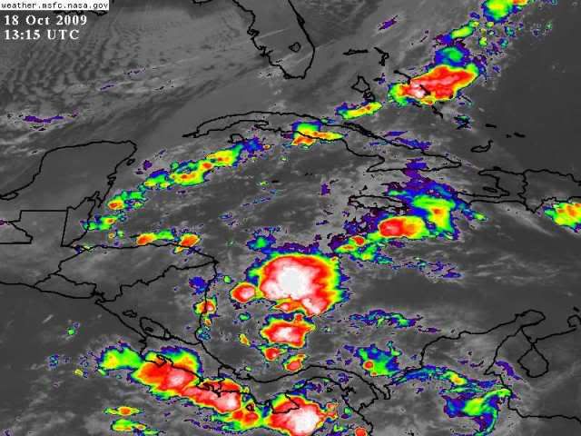
cycloneye
- Admin
- Posts: 149514
- Age: 69
- Joined: Thu Oct 10, 2002 10:54 am
- Location: San Juan, Puerto Rico
Re: Hurricane in Western Caribbean?

0 likes
Visit the Caribbean-Central America Weather Thread where you can find at first post web cams,radars
and observations from Caribbean basin members Click Here
and observations from Caribbean basin members Click Here

-
wxman57

- Moderator-Pro Met

- Posts: 23175
- Age: 68
- Joined: Sat Jun 21, 2003 8:06 pm
- Location: Houston, TX (southwest)
Re: Hurricane in Western Caribbean?
Definitely something to keep an eye on. But I wouldn't put too much stock on any ECMWF track. Steering currents are constantly changing north of 20N this time of year with the increasingly strong cold fronts. It's all about timing - development timing, cold front timing. GFS doesn't see the potential storm, but it is forecasting strong SW-WSW upper-level winds across the NE Gulf at the time the Euro is bringing the storm into the region. So it's unlikely that this potential storm could threaten the northern Gulf Coast. South Florida and the Bahamas (after Cuba) would be the much more likely targets.
0 likes
-
cycloneye
- Admin
- Posts: 149514
- Age: 69
- Joined: Thu Oct 10, 2002 10:54 am
- Location: San Juan, Puerto Rico
Re: Hurricane in Western Caribbean?
Below is a discussion by Dr Jeff Masters about the Western Caribbean posibilities for development.
In the Atlantic, there have been some modest flare-ups of heavy thunderstorm clusters in the extreme Southwest Caribbean off the coasts of Nicaragua and Panama over the past day. This activity has been too disorganized and limited in extent to prove a threat to develop. However, for the past three days, the ECMWF model has been predicting the eventual development of a tropical storm in this region, sometime during the period October 23 - 25. The GFS and NOGAPS models have also been hinting that conditions may become favorable for tropical storm formation in the Western Caribbean early next week, and we should anticipate the possibility of a late-season tropical storm forming. The regions most likely to be affected by such a storm would be weatern Cuba, the Cayman Islands, Jamaica, Mexico's Yucatan Peninsula, South Florida, and the Bahamas. Stay tuned.
Jeff Masters
0 likes
Visit the Caribbean-Central America Weather Thread where you can find at first post web cams,radars
and observations from Caribbean basin members Click Here
and observations from Caribbean basin members Click Here
Who is online
Users browsing this forum: No registered users and 189 guests