WPAC : TROPICAL DEPRESSION MIRINAE (23W)

Moderator: S2k Moderators

Message
Author
User avatar
metenthusiast
Category 1
Category 1
Posts: 271
Age: 48
Joined: Sun Oct 18, 2009 1:09 am
Location: Manila, Phllippines
Contact:

Re:

#661 Postby metenthusiast » Wed Oct 28, 2009 1:57 am

StormingB81 wrote:So I guess a recurve is now definately out of the question then huh


I am no expert on these matters, but based on the data, models, and analysis... well, you could perish the thought and forget that scenario.

"Personal Forecast Disclaimer:
The posts in this forum are NOT official forecast and should not be used as such. They are just the opinion of the poster and may or may not be backed by sound meteorological data. They are NOT endorsed by any professional institution or storm2k.org. For official information, please refer to the NHC and NWS products."
0 likes   

oaba09
S2K Supporter
S2K Supporter
Posts: 1496
Age: 38
Joined: Thu Oct 01, 2009 10:02 am
Location: Valenzuela, Philippines
Contact:

Re:

#662 Postby oaba09 » Wed Oct 28, 2009 1:58 am

StormingB81 wrote:So I guess a recurve is now definately out of the question then huh


Unfortunately, yes...... :(
0 likes   

dhoeze
Tropical Storm
Tropical Storm
Posts: 130
Age: 43
Joined: Tue Oct 27, 2009 2:32 am
Location: Manila, Philippines

Re: WPAC : TYPHOON MIRINAE (23W)

#663 Postby dhoeze » Wed Oct 28, 2009 1:58 am

I think, government is now ready for this storm, problem is our drainage,floodways,rivers and lakes are not.
They are still in critical level. Every inch of additional rainfall would cause flooding. Our lands here Metro
Manila are still still saturated in water.

I agree with you sir. Prepare for the worse.
0 likes   
"Productivity is never an accident. It is always the result of a commitment to excellence, intelligent planning, and focused effort."

dexterlabio
Category 5
Category 5
Posts: 3468
Joined: Sat Oct 24, 2009 11:50 pm

Re:

#664 Postby dexterlabio » Wed Oct 28, 2009 2:00 am

StormingB81 wrote:So I guess a recurve is now definately out of the question then huh


i guess. but let's just say that there's a low chance for that. possible track for mirinae is from quezon up to aurora-isabela area. if you take a look at the weather maps, there is a strong ridge keeping mirinae from traveling to the west or even a more wsw track.
Last edited by dexterlabio on Wed Oct 28, 2009 2:04 am, edited 1 time in total.
0 likes   
Personal Forecast Disclaimer:
The posts in this forum are NOT official forecast and should not be used as such. They are just the opinion of the poster and may or may not be backed by sound meteorological data. They are NOT endorsed by any professional institution or storm2k.org. For official information, please refer to the NHC and NWS products.

User avatar
metenthusiast
Category 1
Category 1
Posts: 271
Age: 48
Joined: Sun Oct 18, 2009 1:09 am
Location: Manila, Phllippines
Contact:

Re: WPAC : TYPHOON MIRINAE (23W)

#665 Postby metenthusiast » Wed Oct 28, 2009 2:01 am

If that STR over China and Taiwan strengthens even more, this track model would seem more probable

Image

"Personal Forecast Disclaimer:
The posts in this forum are NOT official forecast and should not be used as such. They are just the opinion of the poster and may or may not be backed by sound meteorological data. They are NOT endorsed by any professional institution or storm2k.org. For official information, please refer to the NHC and NWS products."
0 likes   

oaba09
S2K Supporter
S2K Supporter
Posts: 1496
Age: 38
Joined: Thu Oct 01, 2009 10:02 am
Location: Valenzuela, Philippines
Contact:

Re: WPAC : TYPHOON MIRINAE (23W)

#666 Postby oaba09 » Wed Oct 28, 2009 2:02 am

metenthusiast wrote:If that STR over China and Taiwan strengthens even more, this track model would seem more probable

Image

"Personal Forecast Disclaimer:
The posts in this forum are NOT official forecast and should not be used as such. They are just the opinion of the poster and may or may not be backed by sound meteorological data. They are NOT endorsed by any professional institution or storm2k.org. For official information, please refer to the NHC and NWS products."


This is actually what I'm expecting.......worst case scenario........
0 likes   

dexterlabio
Category 5
Category 5
Posts: 3468
Joined: Sat Oct 24, 2009 11:50 pm

Re: WPAC : TYPHOON MIRINAE (23W)

#667 Postby dexterlabio » Wed Oct 28, 2009 2:06 am

oaba09 wrote:
metenthusiast wrote:If that STR over China and Taiwan strengthens even more, this track model would seem more probable

Image

"Personal Forecast Disclaimer:
The posts in this forum are NOT official forecast and should not be used as such. They are just the opinion of the poster and may or may not be backed by sound meteorological data. They are NOT endorsed by any professional institution or storm2k.org. For official information, please refer to the NHC and NWS products."


This is actually what I'm expecting.......worst case scenario........


it seems that the STR over china continues to strengthen as the day passes by. it appears to be more zonal at this moment compared to the last couple of days.
0 likes   
Personal Forecast Disclaimer:
The posts in this forum are NOT official forecast and should not be used as such. They are just the opinion of the poster and may or may not be backed by sound meteorological data. They are NOT endorsed by any professional institution or storm2k.org. For official information, please refer to the NHC and NWS products.

oaba09
S2K Supporter
S2K Supporter
Posts: 1496
Age: 38
Joined: Thu Oct 01, 2009 10:02 am
Location: Valenzuela, Philippines
Contact:

Re: WPAC : TYPHOON MIRINAE (23W)

#668 Postby oaba09 » Wed Oct 28, 2009 2:19 am

Track History
Synoptic Time -Latitude -Longitude -Intensity
200910280600 16.2 136.9 85
200910280000 16.2 138.5 75

200910271800 15.9 140.2 65
200910271200 15.6 142.2 45
200910270600 14.8 143.7 40
200910270000 14.1 145.4 35
200910261800 13.6 146.9 35
200910261200 13.2 148.4 35
200910260600 12.7 149.9 30
200910260000 12.2 151.3 25

Look at the 2 latest track....It's not gaining latitude anymore
0 likes   

dhoeze
Tropical Storm
Tropical Storm
Posts: 130
Age: 43
Joined: Tue Oct 27, 2009 2:32 am
Location: Manila, Philippines

Re: WPAC : TYPHOON MIRINAE (23W)

#669 Postby dhoeze » Wed Oct 28, 2009 2:19 am

drdavisjr wrote:
oaba09 wrote:Looks similar w/ JTWC now.........At least now we have a clearer picture


OK...maybe a little better for Metro Manila.


Guys,

Right now, what is the probability of the Model by AFWI to happen?
Will the ridge be have that much of a strength?


Thanks.
0 likes   
"Productivity is never an accident. It is always the result of a commitment to excellence, intelligent planning, and focused effort."

oaba09
S2K Supporter
S2K Supporter
Posts: 1496
Age: 38
Joined: Thu Oct 01, 2009 10:02 am
Location: Valenzuela, Philippines
Contact:

Re: WPAC : TYPHOON MIRINAE (23W)

#670 Postby oaba09 » Wed Oct 28, 2009 2:22 am

dhoeze wrote:
drdavisjr wrote:
oaba09 wrote:Looks similar w/ JTWC now.........At least now we have a clearer picture


OK...maybe a little better for Metro Manila.


Guys,

Right now, what is the probability of the Model by AFWI to happen?
Will the ridge be have that much of a strength?


Thanks.


It's a big possibility.........In my personal opinion, it seems like the STR is strong enough to "push" the system south of the forecast track
0 likes   

dhoeze
Tropical Storm
Tropical Storm
Posts: 130
Age: 43
Joined: Tue Oct 27, 2009 2:32 am
Location: Manila, Philippines

Re:

#671 Postby dhoeze » Wed Oct 28, 2009 2:22 am

drdavisjr wrote:Image

Latest computer models...JTWC in black.


Guys,

Right now, what is the probability of the Model by AFWI to happen?
Will the ridge be have that much of a strength?


Thanks.
0 likes   
"Productivity is never an accident. It is always the result of a commitment to excellence, intelligent planning, and focused effort."

oaba09
S2K Supporter
S2K Supporter
Posts: 1496
Age: 38
Joined: Thu Oct 01, 2009 10:02 am
Location: Valenzuela, Philippines
Contact:

Re: Re:

#672 Postby oaba09 » Wed Oct 28, 2009 2:28 am

dhoeze wrote:
drdavisjr wrote:Image

Latest computer models...JTWC in black.


Guys,

Right now, what is the probability of the Model by AFWI to happen?
Will the ridge be have that much of a strength?


Thanks.


It's 1 of the 2 possibilities so...I'd say it's quite high...........
0 likes   

User avatar
P.K.
Professional-Met
Professional-Met
Posts: 5149
Joined: Thu Sep 23, 2004 5:57 pm
Location: Watford, England
Contact:

Re: WPAC : TYPHOON MIRINAE (23W)

#673 Postby P.K. » Wed Oct 28, 2009 2:41 am

75kts.

WTPQ21 RJTD 280600
RSMC TROPICAL CYCLONE ADVISORY
NAME TY 0921 MIRINAE (0921)
ANALYSIS
PSTN 280600UTC 16.2N 137.0E GOOD
MOVE W 14KT
PRES 960HPA
MXWD 075KT
GUST 105KT
50KT 70NM
30KT 180NM
FORECAST
24HF 290600UTC 16.0N 131.9E 75NM 70%
MOVE W 12KT
PRES 945HPA
MXWD 080KT
GUST 115KT
48HF 300600UTC 16.4N 127.0E 140NM 70%
MOVE W 12KT
PRES 935HPA
MXWD 085KT
GUST 120KT
72HF 310600UTC 16.3N 122.8E 210NM 70%
MOVE W 11KT
PRES 935HPA
MXWD 085KT
GUST 120KT =
0 likes   

oaba09
S2K Supporter
S2K Supporter
Posts: 1496
Age: 38
Joined: Thu Oct 01, 2009 10:02 am
Location: Valenzuela, Philippines
Contact:

#674 Postby oaba09 » Wed Oct 28, 2009 3:12 am

Image
0 likes   

oaba09
S2K Supporter
S2K Supporter
Posts: 1496
Age: 38
Joined: Thu Oct 01, 2009 10:02 am
Location: Valenzuela, Philippines
Contact:

#675 Postby oaba09 » Wed Oct 28, 2009 3:41 am

Image

WTPN32 PGTW 280900
MSGID/GENADMIN/NAVMARFCSTCEN PEARL HARBOR HI/JTWC//
SUBJ/TROPICAL CYCLONE WARNING//
RMKS/
1. TYPHOON 23W (MIRINAE) WARNING NR 010
01 ACTIVE TROPICAL CYCLONE IN NORTHWESTPAC
MAX SUSTAINED WINDS BASED ON ONE-MINUTE AVERAGE
WIND RADII VALID OVER OPEN WATER ONLY
---
WARNING POSITION:
280600Z --- NEAR 16.2N 136.9E
MOVEMENT PAST SIX HOURS - 270 DEGREES AT 15 KTS
POSITION ACCURATE TO WITHIN 040 NM
POSITION BASED ON CENTER LOCATED BY SATELLITE
PRESENT WIND DISTRIBUTION:
MAX SUSTAINED WINDS - 085 KT, GUSTS 105 KT
WIND RADII VALID OVER OPEN WATER ONLY
RADIUS OF 064 KT WINDS - 020 NM NORTHEAST QUADRANT
020 NM SOUTHEAST QUADRANT
020 NM SOUTHWEST QUADRANT
020 NM NORTHWEST QUADRANT
RADIUS OF 050 KT WINDS - 045 NM NORTHEAST QUADRANT
030 NM SOUTHEAST QUADRANT
035 NM SOUTHWEST QUADRANT
045 NM NORTHWEST QUADRANT
RADIUS OF 034 KT WINDS - 090 NM NORTHEAST QUADRANT
065 NM SOUTHEAST QUADRANT
060 NM SOUTHWEST QUADRANT
100 NM NORTHWEST QUADRANT
REPEAT POSIT: 16.2N 136.9E
---
FORECASTS:
12 HRS, VALID AT:
281800Z --- 16.5N 133.7E
MAX SUSTAINED WINDS - 095 KT, GUSTS 115 KT
WIND RADII VALID OVER OPEN WATER ONLY
RADIUS OF 064 KT WINDS - 025 NM NORTHEAST QUADRANT
025 NM SOUTHEAST QUADRANT
025 NM SOUTHWEST QUADRANT
025 NM NORTHWEST QUADRANT
RADIUS OF 050 KT WINDS - 050 NM NORTHEAST QUADRANT
040 NM SOUTHEAST QUADRANT
045 NM SOUTHWEST QUADRANT
050 NM NORTHWEST QUADRANT
RADIUS OF 034 KT WINDS - 100 NM NORTHEAST QUADRANT
080 NM SOUTHEAST QUADRANT
075 NM SOUTHWEST QUADRANT
105 NM NORTHWEST QUADRANT
VECTOR TO 24 HR POSIT: 275 DEG/ 15 KTS
---
24 HRS, VALID AT:
290600Z --- 16.7N 130.6E
MAX SUSTAINED WINDS - 100 KT, GUSTS 125 KT
WIND RADII VALID OVER OPEN WATER ONLY
RADIUS OF 064 KT WINDS - 030 NM NORTHEAST QUADRANT
030 NM SOUTHEAST QUADRANT
030 NM SOUTHWEST QUADRANT
030 NM NORTHWEST QUADRANT
RADIUS OF 050 KT WINDS - 055 NM NORTHEAST QUADRANT
050 NM SOUTHEAST QUADRANT
050 NM SOUTHWEST QUADRANT
055 NM NORTHWEST QUADRANT
RADIUS OF 034 KT WINDS - 105 NM NORTHEAST QUADRANT
090 NM SOUTHEAST QUADRANT
090 NM SOUTHWEST QUADRANT
110 NM NORTHWEST QUADRANT
VECTOR TO 36 HR POSIT: 270 DEG/ 12 KTS
---
36 HRS, VALID AT:
291800Z --- 16.7N 128.0E
MAX SUSTAINED WINDS - 105 KT, GUSTS 130 KT
WIND RADII VALID OVER OPEN WATER ONLY
RADIUS OF 064 KT WINDS - 035 NM NORTHEAST QUADRANT
035 NM SOUTHEAST QUADRANT
035 NM SOUTHWEST QUADRANT
035 NM NORTHWEST QUADRANT
RADIUS OF 050 KT WINDS - 060 NM NORTHEAST QUADRANT
055 NM SOUTHEAST QUADRANT
055 NM SOUTHWEST QUADRANT
060 NM NORTHWEST QUADRANT
RADIUS OF 034 KT WINDS - 115 NM NORTHEAST QUADRANT
100 NM SOUTHEAST QUADRANT
100 NM SOUTHWEST QUADRANT
120 NM NORTHWEST QUADRANT
VECTOR TO 48 HR POSIT: 270 DEG/ 11 KTS
---
EXTENDED OUTLOOK:
48 HRS, VALID AT:
300600Z --- 16.7N 125.7E
MAX SUSTAINED WINDS - 105 KT, GUSTS 130 KT
WIND RADII VALID OVER OPEN WATER ONLY
RADIUS OF 064 KT WINDS - 035 NM NORTHEAST QUADRANT
035 NM SOUTHEAST QUADRANT
035 NM SOUTHWEST QUADRANT
035 NM NORTHWEST QUADRANT
RADIUS OF 050 KT WINDS - 060 NM NORTHEAST QUADRANT
055 NM SOUTHEAST QUADRANT
060 NM SOUTHWEST QUADRANT
065 NM NORTHWEST QUADRANT
RADIUS OF 034 KT WINDS - 115 NM NORTHEAST QUADRANT
105 NM SOUTHEAST QUADRANT
110 NM SOUTHWEST QUADRANT
120 NM NORTHWEST QUADRANT
VECTOR TO 72 HR POSIT: 270 DEG/ 09 KTS
---
72 HRS, VALID AT:
310600Z --- 16.7N 121.8E
MAX SUSTAINED WINDS - 090 KT, GUSTS 110 KT
WIND RADII VALID OVER OPEN WATER ONLY
RADIUS OF 064 KT WINDS - 035 NM NORTHEAST QUADRANT
035 NM SOUTHEAST QUADRANT
035 NM SOUTHWEST QUADRANT
035 NM NORTHWEST QUADRANT
RADIUS OF 050 KT WINDS - 060 NM NORTHEAST QUADRANT
055 NM SOUTHEAST QUADRANT
055 NM SOUTHWEST QUADRANT
060 NM NORTHWEST QUADRANT
RADIUS OF 034 KT WINDS - 120 NM NORTHEAST QUADRANT
110 NM SOUTHEAST QUADRANT
115 NM SOUTHWEST QUADRANT
125 NM NORTHWEST QUADRANT
VECTOR TO 96 HR POSIT: 265 DEG/ 10 KTS
---
LONG RANGE OUTLOOK:
NOTE...ERRORS FOR TRACK HAVE AVERAGED NEAR 250 NM
ON DAY 4 AND 350 NM ON DAY 5... AND FOR INTENSITY
NEAR 20 KT EACH DAY.
---
96 HRS, VALID AT:
010600Z --- 16.4N 117.8E
MAX SUSTAINED WINDS - 080 KT, GUSTS 100 KT
WIND RADII VALID OVER OPEN WATER ONLY
VECTOR TO 120 HR POSIT: 270 DEG/ 11 KTS
---
120 HRS, VALID AT:
020600Z --- 16.2N 113.2E
MAX SUSTAINED WINDS - 070 KT, GUSTS 085 KT
WIND RADII VALID OVER OPEN WATER ONLY
---
REMARKS:
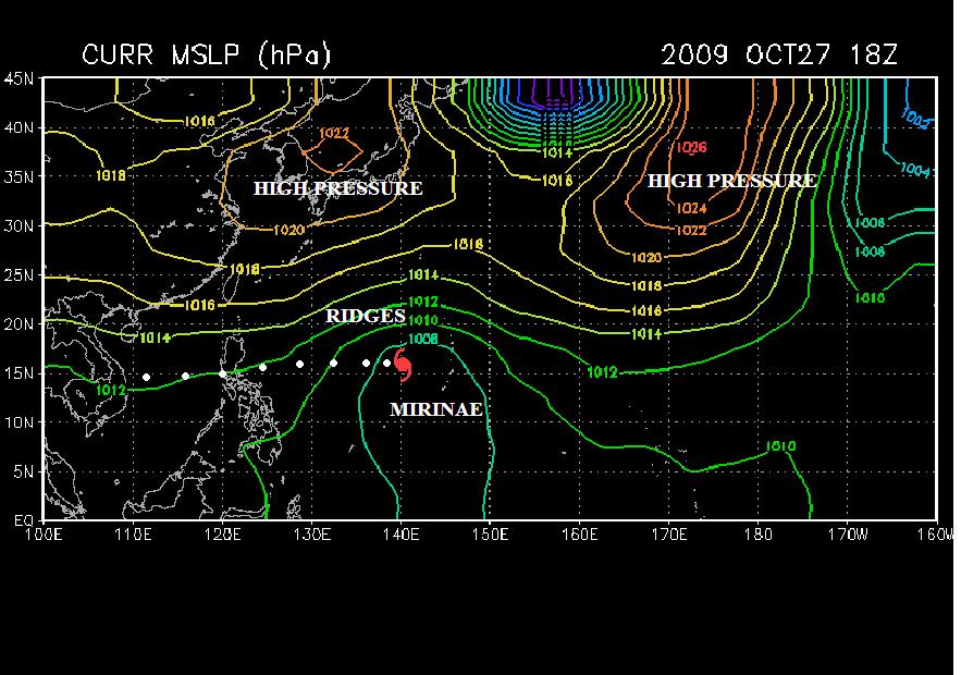
280900Z POSITION NEAR 16.3N 136.1E.
TYPHOON (TY) 23W (MIRINAE), LOCATED APPROXIMATELY 930 NM EAST OF
MANILA, PHILIPPINES, HAS TRACKED WESTWARD AT 15 KNOTS OVER THE PAST
SIX HOURS. DVORAK ESTIMATES FROM PGTW, KNES AND RJTD INDICATE AN 80
TO 90 KNOT CYCLONE. THE SYSTEM HAS INTENSIFIED 10 KNOTS SINCE THE
PREVIOUS FORECAST, DUE IN PART TO SUSTAINED POLEWARD OUTFLOW INTO AN
UPPER LEVEL TROUGH PASSING TO THE NORTH. STRONG RADIAL OUTFLOW AND
WARM SEA SURFACE TEMPERATURES HAVE ALSO BEEN FACTORS IN INTEN-
SIFICATION, AND WILL PROMOTE FURTHER INTENSIFICATION AS POLEWARD
OUTFLOW BEGINS TO SHUT DOWN OVER THE NEXT 06 TO 12 HOURS. LANDFALL
WITH LUZON IS STILL EXPECTED TO OCCUR AROUND 31/06Z, AFTER WHICH
MIRINAE WILL EMERGE INTO THE SOUTH CHINA SEA AS A WEAKENED TYPHOON.
THE FORECAST TRACK REFLECTS A TIGHT GROUPING AMONG THE CONSENSUS
MEMBERS INDICATING A GENERALLY WESTWARD TRACK. MAXIMUM SIGNIFICANT
WAVE HEIGHT AT 280600Z IS 22 FEET. NEXT WARNINGS AT 281500Z,
282100Z, 290300Z AND 290900Z.//
NNNN
0 likes   

User avatar
ManilaTC
WesternPacificWeather.com
Posts: 593
Age: 47
Joined: Mon Oct 26, 2009 5:13 am
Location: Mandaluyong City, Philippines
Contact:

Re: WPAC : TYPHOON MIRINAE (23W)

#676 Postby ManilaTC » Wed Oct 28, 2009 3:56 am

Image

Here is another batch of model runs. Take note of the Gray line, which is from a european model (UKMET)

Most of the models are signifying a dive because of the very strong ridge.
0 likes   
The above post is NOT official and should not be used as such. It is my opinion and may or may not be backed by sound meteorological data. It is not endorsed by any professional institution or storm2k.org. Please refer to your official national weather agency.

WEB http://goo.gl/JDiKXB | FB https://goo.gl/N5sIle | @ManilaTC

oaba09
S2K Supporter
S2K Supporter
Posts: 1496
Age: 38
Joined: Thu Oct 01, 2009 10:02 am
Location: Valenzuela, Philippines
Contact:

Re: WPAC : TYPHOON MIRINAE (23W)

#677 Postby oaba09 » Wed Oct 28, 2009 4:05 am

ClarkEligue wrote:Image

Here is another batch of model runs. Take note of the Gray line, which is from a european model (UKMET)

Most of the models are signifying a dive because of the very strong ridge.


I'm actually expecting that to happen.............We need to watch the movement of MIRINAE in the next couple of hours..
0 likes   

dexterlabio
Category 5
Category 5
Posts: 3468
Joined: Sat Oct 24, 2009 11:50 pm

Re: WPAC : TYPHOON MIRINAE (23W)

#678 Postby dexterlabio » Wed Oct 28, 2009 4:09 am

i think jtwc is not considering the STR strong enough to dive mirinae significantly south of its forecast track. looks like it is still heading generally westwards.
0 likes   
Personal Forecast Disclaimer:
The posts in this forum are NOT official forecast and should not be used as such. They are just the opinion of the poster and may or may not be backed by sound meteorological data. They are NOT endorsed by any professional institution or storm2k.org. For official information, please refer to the NHC and NWS products.

oaba09
S2K Supporter
S2K Supporter
Posts: 1496
Age: 38
Joined: Thu Oct 01, 2009 10:02 am
Location: Valenzuela, Philippines
Contact:

Re: WPAC : TYPHOON MIRINAE (23W)

#679 Postby oaba09 » Wed Oct 28, 2009 4:23 am

dexterlabio wrote:i think jtwc is not considering the STR strong enough to dive mirinae significantly south of its forecast track. looks like it is still heading generally westwards.


Yup....I think we'll have a better idea tomorrow.....
0 likes   

oaba09
S2K Supporter
S2K Supporter
Posts: 1496
Age: 38
Joined: Thu Oct 01, 2009 10:02 am
Location: Valenzuela, Philippines
Contact:

#680 Postby oaba09 » Wed Oct 28, 2009 4:40 am

mirinae appears to be continuously moving westwards as of the moment......
0 likes   


Return to “2009”

Who is online

Users browsing this forum: No registered users and 10 guests