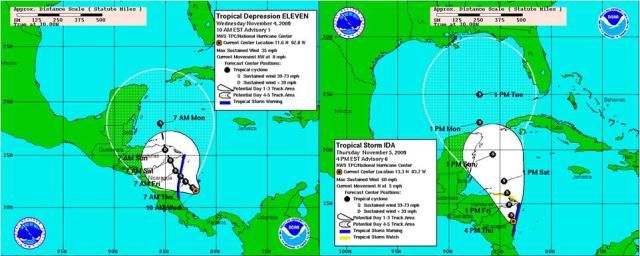
...SUMMARY OF 400 PM EST INFORMATION...
LOCATION...13.3N 83.7W
MAXIMUM SUSTAINED WINDS...60 MPH
PRESENT MOVEMENT...NORTH-NORTHWEST OR 330 DEGREES AT 3 MPH
MINIMUM CENTRAL PRESSURE...990 MB
ATL : TROPICAL DEPRESSION IDA
Moderator: S2k Moderators
-
cycloneye

- Admin

- Posts: 149753
- Age: 69
- Joined: Thu Oct 10, 2002 10:54 am
- Location: San Juan, Puerto Rico
Re: ATL : TROPICAL STORM IDA
0 likes
Visit the Caribbean-Central America Weather Thread where you can find at first post web cams,radars
and observations from Caribbean basin members Click Here
and observations from Caribbean basin members Click Here

We've seen that happen before with these systems before however we shall see, timing is as per normal very important with regards to whether the system beats the increasing shear into the southern gulf or not. If it doesn't then unless it does get scooted off to the NE its going to be destroyed thats for sure.
0 likes
Personal Forecast Disclaimer:
The posts in this forum are NOT official forecast and should not be used as such. They are just the opinion of the poster and may or may not be backed by sound meteorological data. They are NOT endorsed by any professional institution or storm2k.org. For official information, please refer to the NHC and NWS products
The posts in this forum are NOT official forecast and should not be used as such. They are just the opinion of the poster and may or may not be backed by sound meteorological data. They are NOT endorsed by any professional institution or storm2k.org. For official information, please refer to the NHC and NWS products
-
cycloneye
- Admin
- Posts: 149753
- Age: 69
- Joined: Thu Oct 10, 2002 10:54 am
- Location: San Juan, Puerto Rico
Re: ATL : TROPICAL STORM IDA

0 likes
Visit the Caribbean-Central America Weather Thread where you can find at first post web cams,radars
and observations from Caribbean basin members Click Here
and observations from Caribbean basin members Click Here
-
ozonepete
- Professional-Met

- Posts: 4743
- Joined: Mon Sep 07, 2009 3:23 pm
- Location: From Ozone Park, NYC / Now in Brooklyn, NY
Re: ATL : TROPICAL STORM IDA
cycloneye wrote:...SUMMARY OF 400 PM EST INFORMATION...
LOCATION...13.3N 83.7W
MAXIMUM SUSTAINED WINDS...60 MPH
PRESENT MOVEMENT...NORTH-NORTHWEST OR 330 DEGREES AT 3 MPH
MINIMUM CENTRAL PRESSURE...990 MB
Sounds right to me.
0 likes
-
ozonepete
- Professional-Met
- Posts: 4743
- Joined: Mon Sep 07, 2009 3:23 pm
- Location: From Ozone Park, NYC / Now in Brooklyn, NY
Re: ATL : TROPICAL STORM IDA
BTW, anyone notice that the graph says N at 5mph while the advisory says NNW at 3?
0 likes
Interesting that the NHC are still showing that bend to the NNW/NW again in a few days time, will be interesting to see if that actually occurs.
0 likes
Personal Forecast Disclaimer:
The posts in this forum are NOT official forecast and should not be used as such. They are just the opinion of the poster and may or may not be backed by sound meteorological data. They are NOT endorsed by any professional institution or storm2k.org. For official information, please refer to the NHC and NWS products
The posts in this forum are NOT official forecast and should not be used as such. They are just the opinion of the poster and may or may not be backed by sound meteorological data. They are NOT endorsed by any professional institution or storm2k.org. For official information, please refer to the NHC and NWS products
-
cycloneye
- Admin
- Posts: 149753
- Age: 69
- Joined: Thu Oct 10, 2002 10:54 am
- Location: San Juan, Puerto Rico
Re: ATL : TROPICAL STORM IDA
ozonepete wrote:BTW, anyone notice that the graph says N at 5mph while the advisory says NNW at 3?
I just noticed that.Maybe a glitch?
0 likes
Visit the Caribbean-Central America Weather Thread where you can find at first post web cams,radars
and observations from Caribbean basin members Click Here
and observations from Caribbean basin members Click Here
-
MGC

- S2K Supporter

- Posts: 5941
- Joined: Sun Mar 23, 2003 9:05 pm
- Location: Pass Christian MS, or what is left.
Re: ATL : TROPICAL STORM IDA
Only time will tell if Ida survives CA. I still think it will. Ida still has a pretty decent cloud pattern despite being inland for a while now. Key will be how far Ida moves west. A west component will prolong the time over land. As long as a decent mid level circulation remains intact the cyclone should survive the trek across CA. Interesting but NWS Slidell has issued a coastal flood statement as tides are expected to increase due to strong winds caused by the pressure gradient between Ida and high pressure to our NE. SE Louisiana in now in the 5 day cone, kinda weird for November. Thankfully this is not August...MGC
0 likes
-
ozonepete
- Professional-Met
- Posts: 4743
- Joined: Mon Sep 07, 2009 3:23 pm
- Location: From Ozone Park, NYC / Now in Brooklyn, NY
Re: ATL : TROPICAL STORM IDA
It looks like it may be going due north now - if so, that's obviously not good.
0 likes
-
Blown Away

- S2K Supporter
- Posts: 10253
- Joined: Wed May 26, 2004 6:17 am
Re: ATL : TROPICAL STORM IDA
The NHC has been shifting the short term track slightly to the east with each advisory and this will keep more of the circulation envelope over water and the center will spend less time over land.
http://www.nhc.noaa.gov/archive/2009/gr ... 5NLW.shtml
http://www.nhc.noaa.gov/archive/2009/gr ... 5NLW.shtml
0 likes
Hurricane Eye Experience: David 79, Irene 99, Frances 04, Jeanne 04, Wilma 05… Hurricane Brush Experience: Andrew 92, Erin 95, Floyd 99, Matthew 16, Irma 17, Ian 22, Nicole 22…


-
CourierPR

- Category 5

- Posts: 1336
- Age: 72
- Joined: Tue Aug 31, 2004 7:53 pm
- Location: Pompano Beach, Florida
Re:
Yes, last night on NBC6 in Miami, local Met John Gerard said Ida needed to be watched. Usually he goes in the opposite direction regarding possible threats from storms.Decomdoug wrote:With the slight shift to the east, I wonder how long before the Florida media frenzy cranks up.
0 likes
-
cycloneye
- Admin
- Posts: 149753
- Age: 69
- Joined: Thu Oct 10, 2002 10:54 am
- Location: San Juan, Puerto Rico
Re:
HURAKAN wrote:
BIG DIFFERENCE
West - Yesterday 10 AM
East - Now 4 PM
To add about the track east shift,if it moves more faster it will spend much less time over land.
0 likes
Visit the Caribbean-Central America Weather Thread where you can find at first post web cams,radars
and observations from Caribbean basin members Click Here
and observations from Caribbean basin members Click Here
-
Blown Away
- S2K Supporter
- Posts: 10253
- Joined: Wed May 26, 2004 6:17 am
Re: ATL : TROPICAL STORM IDA
0 likes
Hurricane Eye Experience: David 79, Irene 99, Frances 04, Jeanne 04, Wilma 05… Hurricane Brush Experience: Andrew 92, Erin 95, Floyd 99, Matthew 16, Irma 17, Ian 22, Nicole 22…
-
cycloneye
- Admin
- Posts: 149753
- Age: 69
- Joined: Thu Oct 10, 2002 10:54 am
- Location: San Juan, Puerto Rico
Re: ATL : TROPICAL STORM IDA - Models
18z GFS at 120 hours.

150 hours.Almost at the same area.

150 hours.Almost at the same area.
0 likes
Visit the Caribbean-Central America Weather Thread where you can find at first post web cams,radars
and observations from Caribbean basin members Click Here
and observations from Caribbean basin members Click Here
-
ozonepete
- Professional-Met
- Posts: 4743
- Joined: Mon Sep 07, 2009 3:23 pm
- Location: From Ozone Park, NYC / Now in Brooklyn, NY
Re: ATL : TROPICAL STORM IDA
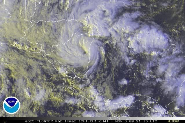
Nice RGB image here. The eye is plainly visible so it'll be easier to track movement. But watch out for wobbles. Even eyes in weaker storms like this can wobble when they're over land due to frictional effects.
0 likes

Re: ATL : TROPICAL STORM IDA
Texas has issued a coastal flood advisory as well....expecting that blob to develop I guess.......very very interesting.....especially this late in the game.....
0 likes
-
Ivanhater

- Storm2k Moderator

- Posts: 11222
- Age: 39
- Joined: Fri Jul 01, 2005 8:25 am
- Location: Pensacola
Re: ATL : TROPICAL STORM IDA - Models
18z GFS never gets Ida out of the Caribbean and pushes her back south
0 likes
Michael
-
ozonepete
- Professional-Met
- Posts: 4743
- Joined: Mon Sep 07, 2009 3:23 pm
- Location: From Ozone Park, NYC / Now in Brooklyn, NY
Re: ATL : TROPICAL STORM IDA
Boy is this moving slowly! But it looks like it's going almost due north.
0 likes
Who is online
Users browsing this forum: No registered users and 110 guests