ATL : TROPICAL DEPRESSION IDA

Moderator: S2k Moderators

Message
Author
User avatar
gatorcane
S2K Supporter
S2K Supporter
Posts: 23692
Age: 47
Joined: Sun Mar 13, 2005 3:54 pm
Location: Boca Raton, FL

Re: ATL : HURRICANE IDA

#2621 Postby gatorcane » Sun Nov 08, 2009 9:24 am

wxman57 wrote:I think Ida's about peaked in intensity now. Cloud tops are starting to warm. Latest model guidance puts what's left of Ida on the Gulf Coast Monday night. At that point it will be embedded in the jet core along the cold front. Moisture will be stripped off north of the center during the day Monday, so there won't be much to make "landfall" on the Gulf Coast. Ida will merge with the frontal low Tuesday morning and the whole mess will become a big Nor'easter Wednesday night/Thursday.

I just don't buy that hooking track to the southeast. I don't think there will be anything left of Ida to do that. Fewer models are showing the hook, and I suspect the NHC will give up on it soon.


The posts in this forum are NOT official forecast and should not be used as such. They are just the opinion of the poster and may or may not be backed by sound meteorological data. They are NOT endorsed by any professional institution or storm2k.org. For official information, please refer to the NHC and NWS products.

Yeah I agree with this forecast. In fact I think its starting the process of getting that large "comma" shape as it now starts to gain more lattitude and wind shear begins to increase from here on out. Should be a sheared mess by the time it reaches the Northern GOM and likely absorbed into the front and ejected NE. In fact probably won't be too tropical in the Northern GOM at all, more of a winter-like system. There will be some good winds, but mostly because of tight pressure gradients and not because of any "eye-wall" or hurricane-induced winds. The majority of the strongest winds will stay well offshore the Panhandle and Northern Gulf coast.
0 likes   

Javlin
Category 5
Category 5
Posts: 1621
Age: 64
Joined: Fri Jul 09, 2004 7:58 pm
Location: ms gulf coast

Re: ATL : HURRICANE IDA

#2622 Postby Javlin » Sun Nov 08, 2009 9:29 am

Why Wxman57 do the models keep up that intensity?You go look at the Cimiss map's and the shear is present even though there is shear decline but 50 to 40 or 30 is very healty shear.The euro,cmc and nogaps all take it over further W over the warm pocket in the GOM
0 likes   

User avatar
gatorcane
S2K Supporter
S2K Supporter
Posts: 23692
Age: 47
Joined: Sun Mar 13, 2005 3:54 pm
Location: Boca Raton, FL

Re: ATL : HURRICANE IDA

#2623 Postby gatorcane » Sun Nov 08, 2009 9:37 am

Javlin wrote:Why Wxman57 do the models keep up that intensity?You go look at the Cimiss map's and the shear is present even though there is shear decline but 50 to 40 or 30 is very healty shear.The euro,cmc and nogaps all take it over further W over the warm pocket in the GOM


Take a look at how the shear is increasingly fairly steadily now across the Central and Northern GOM. Then way off to the NW across the Western US, you see some white showing up indicating that the trough is there and that will amplify and push SE very quickly over the next couple of days. Also SSTs are quite marginal along the northern GOM coast, in fact right near the coast they are quite cool after a period of lows in the 40s and 50s the past several days.

For example take a look at a buoy off Pensacola (buoy 42012). Water temperature there is 73.4F, well below the threshold:
http://www.ndbc.noaa.gov/station_page.php?station=42012

Most of the SSTs at the buoys I am looking at across the N. Central COM are around 75F-78F, which is marginal (perhaps the right word is nominal).

Image
Last edited by gatorcane on Sun Nov 08, 2009 9:41 am, edited 3 times in total.
0 likes   

Dean4Storms
S2K Supporter
S2K Supporter
Posts: 6358
Age: 62
Joined: Sun Aug 31, 2003 1:01 pm
Location: Miramar Bch. FL

#2624 Postby Dean4Storms » Sun Nov 08, 2009 9:38 am

I don't see the clouds tops warming.

http://www.ssd.noaa.gov/goes/flt/t2/flash-avn.html


I look at intensity models and they show a hurricane or top in TS right to landfall. I'm afraid folks are going to begin hearing this sheared, cooler SST's, transition talk and take this storm lightly and we end up getting a big surprise. I already had a neighbor this morning tell me he heard it would weaken and turn away, that we wouldn't see anything more than a little rain.
0 likes   

Dean4Storms
S2K Supporter
S2K Supporter
Posts: 6358
Age: 62
Joined: Sun Aug 31, 2003 1:01 pm
Location: Miramar Bch. FL

Re: ATL : HURRICANE IDA

#2625 Postby Dean4Storms » Sun Nov 08, 2009 9:42 am

gatorcane wrote:
Javlin wrote:Why Wxman57 do the models keep up that intensity?You go look at the Cimiss map's and the shear is present even though there is shear decline but 50 to 40 or 30 is very healty shear.The euro,cmc and nogaps all take it over further W over the warm pocket in the GOM


Take a look at how the shear is increasingly fairly steadily now across the Central and Northern GOM. Then way off to the NW across the Western US, you see some white showing up indicating that the trough is there and that will amplify and push SE very quickly over the next couple of days. Also SSTs are quite marginal along the northern GOM coast, in fact right near the coast they are quite cool after a period of lows in the 40s and 50s the past several days.

Image


Gator, all the buoys show SST in the upper 70's most at 78. We have not gotten down to even the 50's the last several days down here right along the coast, you are seeing inland temps evidently. The coldest temp so far this fall that I have recorded on my Davis Inst. Weather Station has been 55 and that was a good while back after that cold shot in Oct.

That buoy you picked is just offshore, hardly indicative of most of the north Gulf. and just out the Mobile Bay.
Last edited by Dean4Storms on Sun Nov 08, 2009 9:45 am, edited 1 time in total.
0 likes   

User avatar
deltadog03
Professional-Met
Professional-Met
Posts: 3580
Joined: Tue Jul 05, 2005 6:16 pm
Location: Macon, GA

#2626 Postby deltadog03 » Sun Nov 08, 2009 9:43 am

No doubt SST are cooler, for goodness sake its november, however IMO the shear won't be deadly until very near landfall. And its moving quickly enough that the SST's will only slowly degrade it not rapidly destroy it.
0 likes   

User avatar
Dionne
S2K Supporter
S2K Supporter
Posts: 1616
Age: 74
Joined: Mon Jan 02, 2006 8:51 am
Location: SW Mississippi....Alaska transplant via a Southern Belle.

Re: ATL : HURRICANE IDA

#2627 Postby Dionne » Sun Nov 08, 2009 9:44 am

Time to gas up the run truck. Just in case.....better safe than sorry.
Last edited by Dionne on Sun Nov 08, 2009 9:45 am, edited 1 time in total.
0 likes   

User avatar
cycloneye
Admin
Admin
Posts: 145609
Age: 68
Joined: Thu Oct 10, 2002 10:54 am
Location: San Juan, Puerto Rico

Re: ATL : HURRICANE IDA

#2628 Postby cycloneye » Sun Nov 08, 2009 9:45 am

AT 900 AM CST...1500 UTC...A HURRICANE WATCH IS IN EFFECT FROM GRAND
ISLE LOUISIANA TO THE MISSISSIPPI/ALABAMA BORDER. THIS WATCH DOES
NOT INCLUDE THE CITY OF NEW ORLEANS. A HURRICANE WATCH MEANS THAT
HURRICANE CONDITIONS ARE POSSIBLE WITHIN THE WATCH AREA...GENERALLY
WITHIN 36 HOURS.


...SUMMARY OF 900 AM CST INFORMATION...
LOCATION...21.2N 86.0W
MAXIMUM SUSTAINED WINDS...90 MPH
PRESENT MOVEMENT...NORTHWEST OR 325 DEGREES AT 10 MPH
MINIMUM CENTRAL PRESSURE...983 MB
0 likes   
Visit the Caribbean-Central America Weather Thread where you can find at first post web cams,radars
and observations from Caribbean basin members Click Here

User avatar
cycloneye
Admin
Admin
Posts: 145609
Age: 68
Joined: Thu Oct 10, 2002 10:54 am
Location: San Juan, Puerto Rico

Re: ATL : HURRICANE IDA - Advisories

#2629 Postby cycloneye » Sun Nov 08, 2009 9:47 am

000
WTNT31 KNHC 081447
TCPAT1
BULLETIN
HURRICANE IDA ADVISORY NUMBER 18
NWS TPC/NATIONAL HURRICANE CENTER MIAMI FL AL112009
900 AM CST SUN NOV 08 2009

...CENTER OF IDA MOVING INTO THE YUCATAN CHANNEL...HURRICANE WATCH
ISSUED FOR PORTIONS OF THE NORTHERN GULF COAST...

AT 900 AM CST...1500 UTC...A HURRICANE WATCH IS IN EFFECT FROM GRAND
ISLE LOUISIANA TO THE MISSISSIPPI/ALABAMA BORDER. THIS WATCH DOES
NOT INCLUDE THE CITY OF NEW ORLEANS. A HURRICANE WATCH MEANS THAT
HURRICANE CONDITIONS ARE POSSIBLE WITHIN THE WATCH AREA...GENERALLY
WITHIN 36 HOURS.

A HURRICANE WARNING REMAINS IN EFFECT FOR THE YUCATAN PENINSULA OF
MEXICO FROM PLAYA DEL CARMEN TO CABO CATOCHE. A HURRICANE WARNING
MEANS THAT HURRICANE CONDITIONS ARE EXPECTED SOMEWHERE WITHIN THE
WARNING AREA WITHIN 24 HOURS. PREPARATIONS TO PROTECT LIFE AND
PROPERTY SHOULD BE RUSHED TO COMPLETION IN THE WARNING AREA.

A HURRICANE WATCH REMAINS IN EFFECT FOR THE YUCATAN PENINSULA OF
MEXICO FROM TULUM TO PLAYA DEL CARMEN. A HURRICANE WATCH MEANS THAT
HURRICANE CONDITIONS ARE POSSIBLE WITHIN THE WATCH AREA.

A TROPICAL STORM WARNING REMAINS IN EFFECT FOR THE YUCATAN PENINSULA
OF MEXICO FROM PUNTA ALLEN NORTHWARD TO PLAYA DEL CARMEN AND FROM
CABO CATOCHE WESTWARD TO SAN FELIPE. A TROPICAL STORM WARNING
MEANS THAT TROPICAL STORM CONDITIONS ARE EXPECTED WITHIN THE
WARNING AREA WITHIN 24 HOURS.

A TROPICAL STORM WARNING REMAINS IN EFFECT FOR THE CUBAN PROVINCE OF
PINAR DEL RIO.

A TROPICAL STORM WATCH REMAINS IN EFFECT FOR THE ISLE OF YOUTH.

INTERESTS ELSEWHERE ALONG THE NORTHERN COAST OF THE GULF OF MEXICO
SHOULD MONITOR THE PROGRESS OF IDA. ADDITIONAL TROPICAL CYCLONE
WATCHES OR WARNINGS MAY BE REQUIRED LATER TODAY.

FOR STORM INFORMATION SPECIFIC TO YOUR AREA IN THE UNITED
STATES...INCLUDING POSSIBLE INLAND WATCHES AND WARNINGS...PLEASE
MONITOR PRODUCTS ISSUED BY YOUR LOCAL NATIONAL WEATHER SERVICE
FORECAST OFFICE. FOR STORM INFORMATION SPECIFIC TO YOUR AREA
OUTSIDE OF THE UNITED STATES...PLEASE MONITOR PRODUCTS ISSUED
BY YOUR NATIONAL METEOROLOGICAL SERVICE.

AT 900 AM CST...1500 UTC...THE CENTER OF HURRICANE IDA WAS LOCATED
NEAR LATITUDE 21.2 NORTH...LONGITUDE 86.0 WEST OR ABOUT 75 MILES...
120 KM...NORTHEAST OF COZUMEL MEXICO AND ABOUT 80 MILES...125 KM...
WEST-SOUTHWEST OF THE WESTERN TIP OF CUBA.

IDA IS MOVING TOWARD THE NORTHWEST NEAR 10 MPH...17 KM/HR. A TURN
TOWARD THE NORTH-NORTHWEST AND AN INCREASE IN FORWARD SPEED ARE
EXPECTED DURING THE NEXT 24 HOURS...WITH A TURN TOWARD THE NORTH
LIKELY BY TUESDAY. ON THE FORECAST TRACK....THE CENTER OF IDA
SHOULD MOVE THROUGH THE YUCATAN CHANNEL INTO THE GULF OF MEXICO
TODAY...AND BE NEAR THE NORTHERN GULF COAST BY TUESDAY.

MAXIMUM SUSTAINED WINDS ARE NEAR 90 MPH...150 KM/HR...WITH HIGHER
GUSTS. IDA IS A CATEGORY ONE HURRICANE ON THE SAFFIR-SIMPSON SCALE.
SOME STRENGTHENING IS FORECAST TODAY...WITH GRADUAL WEAKENING
EXPECTED ON MONDAY. IDA IS EXPECTED TO BEGIN LOSING TROPICAL
CHARACTERISTICS ON TUESDAY AS IT NEARS THE GULF COAST...BUT IT
COULD REACH THE COAST AS A TROPICAL CYCLONE.

HURRICANE FORCE WINDS EXTEND OUTWARD UP TO 15 MILES...30 KM...FROM
THE CENTER...AND TROPICAL STORM FORCE WINDS EXTEND OUTWARD UP TO
140 MILES...220 KM.

ESTIMATED MINIMUM CENTRAL PRESSURE IS 983 MB...29.03 INCHES.

IDA IS EXPECTED TO PRODUCE TOTAL RAIN ACCUMULATIONS OF 3 TO 5 INCHES
OVER PORTIONS OF THE YUCATAN PENINSULA AND WESTERN CUBA...WITH
POSSIBLE ISOLATED MAXIMUM AMOUNTS OF 10 INCHES.

A STORM SURGE COULD RAISE WATER LEVELS BY AS MUCH AS 3 TO 4 FEET
ABOVE GROUND LEVEL ALONG THE COAST OF THE YUCATAN PENINSULA. NEAR
THE COAST...THE SURGE WILL BE ACCOMPANIED BY LARGE AND DESTRUCTIVE
WAVES.

...SUMMARY OF 900 AM CST INFORMATION...
LOCATION...21.2N 86.0W
MAXIMUM SUSTAINED WINDS...90 MPH
PRESENT MOVEMENT...NORTHWEST OR 325 DEGREES AT 10 MPH
MINIMUM CENTRAL PRESSURE...983 MB

AN INTERMEDIATE ADVISORY WILL BE ISSUED BY THE NATIONAL HURRICANE
CENTER AT 1200 PM CST FOLLOWED BY THE NEXT COMPLETE ADVISORY AT 300
PM CST.

$$
FORECASTER BEVEN


0 likes   
Visit the Caribbean-Central America Weather Thread where you can find at first post web cams,radars
and observations from Caribbean basin members Click Here

Dean4Storms
S2K Supporter
S2K Supporter
Posts: 6358
Age: 62
Joined: Sun Aug 31, 2003 1:01 pm
Location: Miramar Bch. FL

#2630 Postby Dean4Storms » Sun Nov 08, 2009 9:51 am

Opal is a good example of a weakening Hurricane over the northern Gulf getting caught up in a frontal boundary, they had hurricane force winds all the way up to Montgomery, AL, this of course was stronger than Ida at landfall but weakening rapidly but even the land friction was not enough to weaken it substantially before it reached east central Alabama and west central GA. The increase in forward speed could allow Ida to maintain strong winds well into the immediate Gulf Coast if she is at hurricane strength just 100-150 miles offshore!
0 likes   

User avatar
cycloneye
Admin
Admin
Posts: 145609
Age: 68
Joined: Thu Oct 10, 2002 10:54 am
Location: San Juan, Puerto Rico

Re: ATL : HURRICANE IDA

#2631 Postby cycloneye » Sun Nov 08, 2009 9:51 am

Image
0 likes   
Visit the Caribbean-Central America Weather Thread where you can find at first post web cams,radars
and observations from Caribbean basin members Click Here

User avatar
HURAKAN
Professional-Met
Professional-Met
Posts: 46086
Age: 38
Joined: Thu May 20, 2004 4:34 pm
Location: Key West, FL
Contact:

#2632 Postby HURAKAN » Sun Nov 08, 2009 9:58 am

Image

Finding the channel!!
0 likes   

User avatar
HURAKAN
Professional-Met
Professional-Met
Posts: 46086
Age: 38
Joined: Thu May 20, 2004 4:34 pm
Location: Key West, FL
Contact:

#2633 Postby HURAKAN » Sun Nov 08, 2009 10:00 am

08/1145 UTC 20.7N 85.7W T4.5/4.5 IDA -- Atlantic

4.5 = 77 knots
0 likes   

User avatar
ronjon
Category 5
Category 5
Posts: 4824
Joined: Fri Aug 19, 2005 5:17 pm
Location: Hernando Beach, FL

Re: ATL : HURRICANE IDA

#2634 Postby ronjon » Sun Nov 08, 2009 10:00 am

Hmmm...seems odd no tropical storm watches for coastal AL and panhandle of FL. This is confusing from the NHC. I understand that its going to transition to ET but the effects will still be the same as a tropical storm. Heck, NHC has the storm at 60 mph over coastal sections of the FL panhandle as a ET storm. Here's a classic case of bureaucratic definitions getting in the way of common sense.
0 likes   

jconsor
Professional-Met
Professional-Met
Posts: 552
Joined: Mon Jun 30, 2008 9:31 pm
Location: Jerusalem, Israel
Contact:

Re: ATL : HURRICANE IDA

#2635 Postby jconsor » Sun Nov 08, 2009 10:00 am

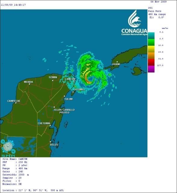
I disagree on the short-term - Ida is likely beginning to strengthen now. There was notable warming of the cloud tops between 11z and 13z, but in the past hour and a half, that trend has reversed. Also, the Cancun radar (http://flhurricane.com/imageanimator.php?70) shows a closed eyewall (while the eyewall has been open to the S-SW for the past 12 hours) and a significant shrinking of the eye size in the past 2 hours.

The 200 mb pattern is favorable for slow strengthening for the next 12-24 hours, as the 200 mb wind forecasts around Ida indicates southerly flow of around 15-20 kt, which is nearly parallel to Ida's expected NNW track. Also, the upper trough in the western Gulf is expected to continue to create a favorable diffluent pattern over Ida for the next 24 hours or so.

You expect that Ida will get ripped apart by shear and cease to exist prior to landfall. The line between positive and negative interaction between tropical systems and troughs is a fine one. However, most of the models (especially the models that have a handle on Ida's current depth and intensity) indicates there will be positive feedback between Ida and the trough, and the strong SW winds aloft will merely accelerate the extratropical transition.

A more likely scenario is that Ida weakens to a strong tropical storm or low-end category 1 and begins to transition to extratropical with a spreading wind field as it approaches the northern Gulf coast. The saving grace is that the strongest winds will most likely be from an offshore direction (N/NW) on the western side of the storm, where the synoptic pressure gradient is tighter. In this scenario, friction from land will cut down on wind speeds, and also the storm surge won't be a big deal except perhaps over parts of southeast Louisiana where northerly winds tend to pile up water.

wxman57 wrote:I think Ida's about peaked in intensity now. Cloud tops are starting to warm. Latest model guidance puts what's left of Ida on the Gulf Coast Monday night. At that point it will be embedded in the jet core along the cold front. Moisture will be stripped off north of the center during the day Monday, so there won't be much to make "landfall" on the Gulf Coast. Ida will merge with the frontal low Tuesday morning and the whole mess will become a big Nor'easter Wednesday night/Thursday.

I just don't buy that hooking track to the southeast. I don't think there will be anything left of Ida to do that. Fewer models are showing the hook, and I suspect the NHC will give up on it soon.
Last edited by jconsor on Sun Nov 08, 2009 10:05 am, edited 3 times in total.
0 likes   

User avatar
drezee
S2K Supporter
S2K Supporter
Posts: 3664
Joined: Mon Jun 09, 2003 12:49 pm
Location: FL

Re: ATL : HURRICANE IDA - Recon

#2636 Postby drezee » Sun Nov 08, 2009 10:01 am

Recon left early for a change:

000
URNT15 KNHC 081451
AF309 0411A IDA HDOB 02 20091108
144330 3024N 08856W 0203 00001 0208 +173 +080 059004 011 999 999 03
144400 3025N 08855W 0139 00037 0201 +166 +084 071010 014 999 999 03
144430 3026N 08855W 9973 00196 0203 +172 +089 096025 028 999 999 03
144500 3027N 08854W 9740 00394 0194 +171 +092 107027 027 999 999 03
144530 3029N 08854W 9294 00788 0193 +146 +094 107024 025 999 999 03
144600 3029N 08855W 9009 01055 0190 +141 +092 103023 024 999 999 03
144630 3029N 08857W 8646 01395 0169 +150 +087 107024 025 999 999 03
144700 3027N 08858W 8305 01737 0164 +146 +082 109022 023 999 999 03
144730 3026N 08859W 8024 02025 0152 +132 +078 121022 022 999 999 03
144800 3024N 08900W 7742 02322 0142 +122 +073 123019 020 999 999 03
144830 3023N 08901W 7482 02608 0138 +105 +068 120021 023 999 999 03
144900 3021N 08901W 7232 02891 0130 +093 +062 123025 026 999 999 03
144930 3020N 08902W 6998 03162 0131 +075 +055 126025 025 999 999 03
145000 3018N 08903W 6778 03424 0135 +054 +048 130025 025 999 999 03
145030 3017N 08904W 6584 03661 0142 +034 +034 129026 028 999 999 03
145100 3015N 08905W 6394 03896 0145 +017 +017 128028 028 999 999 03
145130 3014N 08906W 6210 04132 9990 -003 +999 126029 029 999 999 05
145200 3012N 08907W 6048 04340 9990 -021 +999 122031 032 999 999 05
145230 3011N 08908W 5871 04577 9990 -040 +999 124032 032 999 999 05
145300 3009N 08909W 5730 04771 9990 -053 +999 124031 031 999 999 05
$$
0 likes   

User avatar
cycloneye
Admin
Admin
Posts: 145609
Age: 68
Joined: Thu Oct 10, 2002 10:54 am
Location: San Juan, Puerto Rico

Re: ATL : HURRICANE IDA

#2637 Postby cycloneye » Sun Nov 08, 2009 10:01 am

ronjon wrote:Hmmm...seems odd no tropical storm watches for coastal AL and panhandle of FL. This is confusing from the NHC. I understand that its going to transition to ET but the effects will still be the same as a tropical storm. Heck, NHC has the storm at 60 mph over coastal sections of the FL panhandle as a ET storm. Here's a classic case of bureaucratic definitions getting in the way of common sense.


I am sure that watches and warnings will expand eastward later today.
0 likes   
Visit the Caribbean-Central America Weather Thread where you can find at first post web cams,radars
and observations from Caribbean basin members Click Here

User avatar
drezee
S2K Supporter
S2K Supporter
Posts: 3664
Joined: Mon Jun 09, 2003 12:49 pm
Location: FL

Re: ATL : HURRICANE IDA

#2638 Postby drezee » Sun Nov 08, 2009 10:04 am

cycloneye wrote:
ronjon wrote:Hmmm...seems odd no tropical storm watches for coastal AL and panhandle of FL. This is confusing from the NHC. I understand that its going to transition to ET but the effects will still be the same as a tropical storm. Heck, NHC has the storm at 60 mph over coastal sections of the FL panhandle as a ET storm. Here's a classic case of bureaucratic definitions getting in the way of common sense.


I am sure that watches and warnings will expand eastward later today.


It is all about timing...winds will get to grand isle 6 hours before AL...so six hours later the watches go up...
0 likes   

User avatar
HURAKAN
Professional-Met
Professional-Met
Posts: 46086
Age: 38
Joined: Thu May 20, 2004 4:34 pm
Location: Key West, FL
Contact:

#2639 Postby HURAKAN » Sun Nov 08, 2009 10:05 am

Image

The center of Ida looks like a heart. She's definitely a romantic!!!
0 likes   

User avatar
cycloneye
Admin
Admin
Posts: 145609
Age: 68
Joined: Thu Oct 10, 2002 10:54 am
Location: San Juan, Puerto Rico

Re: ATL : HURRICANE IDA - Recon=Plane is flying towards Ida

#2640 Postby cycloneye » Sun Nov 08, 2009 10:05 am

OB 3

URNT15 KNHC 081501
AF309 0411A IDA HDOB 03 20091108
145330 3008N 08910W 5577 04981 9990 -063 +999 127031 031 999 999 05
145400 3006N 08911W 5447 05166 0231 -075 +999 126031 032 999 999 05
145430 3005N 08912W 5343 05319 0238 -081 +999 117030 031 999 999 05
145500 3003N 08913W 5228 05485 0241 -088 -088 120029 030 999 999 05
145530 3001N 08914W 5088 05690 0249 -095 -095 140027 029 999 999 03
145600 3000N 08915W 4963 05888 0260 -097 -097 161023 024 999 999 03
145630 2958N 08916W 4906 05982 0269 -090 -090 168018 020 999 999 03
145700 2957N 08917W 4884 06015 0271 -085 -092 168017 017 999 999 03
145730 2955N 08917W 4853 06066 0273 -086 -095 167016 017 999 999 03
145800 2953N 08917W 4820 06118 0276 -090 -098 168016 016 999 999 03
145830 2951N 08916W 4788 06174 0282 -095 -101 167015 016 999 999 03
145900 2949N 08916W 4761 06220 0288 -099 -103 176013 013 999 999 03
145930 2947N 08916W 4734 06265 0290 -100 -105 172011 012 999 999 03
150000 2946N 08916W 4703 06315 0293 -105 -106 174010 011 999 999 03
150030 2944N 08916W 4667 06371 0295 -111 -111 177011 012 999 999 03
150100 2942N 08916W 4632 06430 0299 -115 -115 168012 012 999 999 03
150130 2940N 08916W 4610 06467 0301 -117 -117 157011 011 999 999 03
150200 2938N 08916W 4587 06507 0304 -121 -121 154009 009 999 999 03
150230 2936N 08916W 4557 06558 0305 -125 -125 154010 010 999 999 03
150300 2934N 08916W 4523 06613 0308 -130 -130 157012 013 999 999 03
0 likes   
Visit the Caribbean-Central America Weather Thread where you can find at first post web cams,radars
and observations from Caribbean basin members Click Here


Return to “2009”

Who is online

Users browsing this forum: No registered users and 195 guests