Southern Plains winter wx thread (2009-2010)

Winter Weather Discussion

Moderator: S2k Moderators

Forum rules

The posts in this forum are NOT official forecast and should not be used as such. They are just the opinion of the poster and may or may not be backed by sound meteorological data. They are NOT endorsed by any professional institution or STORM2K.

Help Support Storm2K
Message
Author
BlueIce
S2K Supporter
S2K Supporter
Posts: 194
Age: 37
Joined: Mon Sep 01, 2008 10:05 pm
Location: Oklahoma City, Oklahoma

Re: Southern Plains winter wx thread (2009-2010)

#421 Postby BlueIce » Wed Jan 27, 2010 3:04 pm

Extremeweatherguy wrote:Here is my latest personal prediction for the storm...

Image

Image

It looks like the best chance for significant snows will be in northern and northwest Oklahoma, and the best chance for significant ice will be across central Oklahoma extending from the SW to the NE part of the state. There is likely to be a narrow strip of very significant icing within the larger ice storm zone, with amounts exceeding 0.75" within that corridor. Ice amounts of that magnitude coupled with breezy winds will likely cause significant damage to trees and power lines.


The following post is NOT an official forecast and should not be used as such. It is just the opinion of the poster and may or may not be backed by sound meteorological data. It is NOT endorsed by any professional institution including storm2k.org. For official information, please refer to NWS products.


I am thinking we may have another event on level with the December 2007 ice storm. I was really hoping that we were going to get record breaking snow.

Image
0 likes   

BlueIce
S2K Supporter
S2K Supporter
Posts: 194
Age: 37
Joined: Mon Sep 01, 2008 10:05 pm
Location: Oklahoma City, Oklahoma

Re: Southern Plains winter wx thread (2009-2010)

#422 Postby BlueIce » Wed Jan 27, 2010 5:25 pm

Looks like the 18z GFS has reduced the total precip for the event, I would like to see the 00z GFS and NAM to verify this. Just from outside observation there looks to be significant moisture coming in from the southwest. We just need to get that cold air in quicker.

18z GFS
Image

18z NAM
Image
0 likes   

User avatar
Extremeweatherguy
Category 5
Category 5
Posts: 11095
Joined: Mon Oct 10, 2005 8:13 pm
Location: Florida

Re: Southern Plains winter wx thread (2009-2010)

#423 Postby Extremeweatherguy » Wed Jan 27, 2010 6:37 pm

18z NAM accumulation amounts...

OKLAHOMA CITY
Snow accumulation = 1.5"+
Sleet accumulation = 0.27"
Freezing rain accumulation = 2.06"

NORMAN
Snow accumulation = 0.4"+
Sleet accumulation = 0.02"
Freezing rain accumulation = 2.05"

18z GFS accumulation amounts...

OKLAHOMA CITY
Snow accumulation = 2.7"
Sleet accumulation = 0.96"
Freezing rain accumulation = 0.71"

NORMAN
Snow accumulation = 0.8"
Sleet accumulation = 0.63"
Freezing rain accumulation = 1.13"

Overall the trend continues towards this looking more like a major ice storm for OKC/OUN and less of a major snow storm. There will still probably be some snow/sleet at the end, but as of now it doesn't look like that will be the biggest story from this event in central Oklahoma.
0 likes   

User avatar
Ntxw
Storm2k Moderator
Storm2k Moderator
Posts: 22784
Joined: Wed Oct 21, 2009 6:34 pm
Location: DFW, Texas

#424 Postby Ntxw » Wed Jan 27, 2010 6:42 pm

Amazing how quickly models and change.
0 likes   
The above post and any post by Ntxw is NOT an official forecast and should not be used as such. It is just the opinion of the poster and may or may not be backed by sound meteorological data. It is NOT endorsed by any professional institution including Storm2k. For official information, please refer to NWS products.

  Help support Storm2K!
Help Support Storm2K

User avatar
srainhoutx
S2K Supporter
S2K Supporter
Posts: 6919
Age: 67
Joined: Sun Jan 14, 2007 11:34 am
Location: Haywood County, NC
Contact:

Re: Southern Plains winter wx thread (2009-2010)

#425 Postby srainhoutx » Wed Jan 27, 2010 6:42 pm

:uarrow: I agree EWG. The change over line will be critical. I suspect a rather narrow line of heavier snow transitioning to a sleet/freezing rain event. Keep an eye on the QPF totals. :wink: Stay Safe Folks. It's going to be a very long February IMHO.
0 likes   
Carla/Alicia/Jerry(In The Eye)/Michelle/Charley/Ivan/Dennis/Katrina/Rita/Wilma/Ike/Harvey

Member: National Weather Association
Wx Infinity Forums
http://wxinfinity.com/index.php

Facebook.com/WeatherInfinity
Twitter @WeatherInfinity

BlueIce
S2K Supporter
S2K Supporter
Posts: 194
Age: 37
Joined: Mon Sep 01, 2008 10:05 pm
Location: Oklahoma City, Oklahoma

Re: Southern Plains winter wx thread (2009-2010)

#426 Postby BlueIce » Wed Jan 27, 2010 10:26 pm

Anyone have any good updates?
0 likes   

User avatar
Extremeweatherguy
Category 5
Category 5
Posts: 11095
Joined: Mon Oct 10, 2005 8:13 pm
Location: Florida

#427 Postby Extremeweatherguy » Wed Jan 27, 2010 11:03 pm

The 00z NAM and GFS have come in slightly colder at the surface for tomorrow. This helps to solidify the idea that the storm threat is real. In addition, both continue to show freezing rain being the most likely p-type for OKC and OUN through most of tomorrow afternoon, with some possible sleet mixing in by tomorrow evening. The GFS shows a period tomorrow night into Friday morning that looks pretty good (via skew-t) for sleet changing to snow across OKC and OUN with some light accumulations possible.

I have posted the 00z NAM accumulations below, and will post the 00z GFS accumulations when they become available.

OKLAHOMA CITY (NAM Accumulations)
Temperature falls to freezing = 8-9am
Snow accumulation = 0.5"+
Sleet accumulation = 0.0"
Frz Rain accumulation = 1.79"

NORMAN (NAM Accumulations)
Temperature falls to freezing = 8-9am
Snow accumulation = 0.4"+
Sleet accumulation = 0.0"
Frz Rain accumulation = 1.93"
0 likes   

User avatar
Extremeweatherguy
Category 5
Category 5
Posts: 11095
Joined: Mon Oct 10, 2005 8:13 pm
Location: Florida

#428 Postby Extremeweatherguy » Wed Jan 27, 2010 11:35 pm

Here is my latest personal forecast update. It is overall very similar to my earlier forecast, but with a few small shifts in the snow/ice areas based on what I am seeing from the latest model runs. Keep in mind that small changes to these map could still occur as we head into tomorrow based on how the surface 32F line sets up across the area. The biggest "?" is in south and southeast Oklahoma. If the freezing line can get there more quickly then I might need to up their ice totals significantly. As of now they look to avoid the worst of the storm, but a difference of just a few degrees could make all the difference. Another "?" is the upper level cold. Most of the models think freezing rain will be the primary p-type for central Oklahoma for most of tomorrow, but if the upper levels can cool more quickly, then snow/sleet totals would need to be upped, especially for OKC and OUN. Stay tuned!

Image

Image

The following post is NOT an official forecast and should not be used as such. It is just the opinion of the poster and may or may not be backed by sound meteorological data. It is NOT endorsed by any professional institution including storm2k.org. For official information, please refer to NWS products.
0 likes   

msstateguy83

#429 Postby msstateguy83 » Thu Jan 28, 2010 2:22 am

iam in the house this early morning checking the very latest data out... but i must say heads up to ANYONE living in central... southwestern... western...south central oklahoma into western north texas... this is going to be a *MAJOR,MAJOR ICE STORM* no doubt about it we could see amts over 1 inch + in isolated spots from central down into sw ok, wrn n tx.. with widespread 0.50-0.75" amounts... the front is still making very good progress into oklahoma temps still on the fall quite impressively. i will post more later in the am

EDIT: EWG'S MAP cover's things pretty well i would just say to extend the area of 0.75" down the i-44 corridor
past lawton to the red river.

EDIT 2: also would note this is a VERY complex weather situation ongoing currently depending on how the front makes it far south into the am and how much deep cold air we get into the upper levels i still think its possible to get a good amt of snow out by the end of the day in some areas, feel snow amts *MIGHT* have to be raised across the region just something we need to keep an eye on, but quite honestly i would be more worried attm with the threat @ hand which could be far more costly and that is the ice...

The following post is NOT an official forecast and should not be used as such. It is just the opinion of the poster and may or may not be backed by sound meteorological data. It is NOT endorsed by any professional institution including storm2k.org. For official information, please refer to NWS products.
0 likes   

msstateguy83

Re: Southern Plains winter wx thread (2009-2010)

#430 Postby msstateguy83 » Thu Jan 28, 2010 2:52 am

Image
0 likes   

User avatar
Extremeweatherguy
Category 5
Category 5
Posts: 11095
Joined: Mon Oct 10, 2005 8:13 pm
Location: Florida

#431 Postby Extremeweatherguy » Thu Jan 28, 2010 2:57 am

Temperatures are cooling fairly rapidly across the state of Oklahoma this evening...

Image

It is just a matter of time before OKC and surrounding locations fall below 32F.
0 likes   

msstateguy83

Re: Southern Plains winter wx thread (2009-2010)

#432 Postby msstateguy83 » Thu Jan 28, 2010 3:00 am

EWG would you agree its not over 'hypeing it' or overstating it that this is getting cranked up to the top of the scale as of about
now due to how fast this front is moving in? i mean iam convenced we will see a MAJOR winter storm across the main body of ok down into nw tx with possibly even heavy snow still if the upper levels cool down quick enough.
0 likes   

msstateguy83

#433 Postby msstateguy83 » Thu Jan 28, 2010 3:06 am

HOLY! i just checked last obs from the airport here in w.falls still says like 51 i've got 42 at my house n wind @ 22 mph
0 likes   

BlueIce
S2K Supporter
S2K Supporter
Posts: 194
Age: 37
Joined: Mon Sep 01, 2008 10:05 pm
Location: Oklahoma City, Oklahoma

#434 Postby BlueIce » Thu Jan 28, 2010 6:37 am

For the record I HATE Ice. Regardless, I will still be taking photos of the event. I would predict widespread power outages in Oklahoma City tonight. If the last storm is any indication we have a serious situation on our hands.
0 likes   

User avatar
Extremeweatherguy
Category 5
Category 5
Posts: 11095
Joined: Mon Oct 10, 2005 8:13 pm
Location: Florida

Re: Southern Plains winter wx thread (2009-2010)

#435 Postby Extremeweatherguy » Thu Jan 28, 2010 6:48 am

Temperatures are still just above freezing at 5:40am across the central and southern OKC metro areas. It is 33F in Oklahoma City and 36F in Norman according to the mesonet. Wetbulbs in these places are 32F or colder though, so once the precipitation begins it shouldn't take long for us to all fall to near/below freezing. Looking at the radar loop, I would suspect that the beginning of the first band of heavier precipitation is only an hour or less away for southern parts of the metro. Once this band arrives I believe that many zones will see a period of normal rain quickly trying to transition to freezing rain (especially on elevated surfaces, cars, etc) as the surface temperatures drops. Some areas could also see some sleet..and according to the NWS sleet may actually become more likely (especially from the central metro northward) later this morning into the afternoon, so that will definitely be something to keep an eye on.
0 likes   

User avatar
srainhoutx
S2K Supporter
S2K Supporter
Posts: 6919
Age: 67
Joined: Sun Jan 14, 2007 11:34 am
Location: Haywood County, NC
Contact:

Re: Southern Plains winter wx thread (2009-2010)

#436 Postby srainhoutx » Thu Jan 28, 2010 6:58 am

:uarrow: Stay Safe up there folks. Looks like frontogenesis is occurring just W of Seminole, TX to near Carlsbad NM at this hour. Going to be a long 24 hours for sure.
0 likes   
Carla/Alicia/Jerry(In The Eye)/Michelle/Charley/Ivan/Dennis/Katrina/Rita/Wilma/Ike/Harvey

Member: National Weather Association
Wx Infinity Forums
http://wxinfinity.com/index.php

Facebook.com/WeatherInfinity
Twitter @WeatherInfinity

User avatar
srainhoutx
S2K Supporter
S2K Supporter
Posts: 6919
Age: 67
Joined: Sun Jan 14, 2007 11:34 am
Location: Haywood County, NC
Contact:

Re: Southern Plains winter wx thread (2009-2010)

#437 Postby srainhoutx » Thu Jan 28, 2010 7:10 am

PROBABILISTIC HEAVY SNOW AND ICING DISCUSSION
NWS HYDROMETEOROLOGICAL PREDICTION CENTER CAMP SPRINGS MD
457 AM EST THU JAN 28 2010

VALID 12Z THU JAN 28 2010 - 12Z SUN JAN 31 2010


DAYS 1/2...

...FOUR CORNERS/SOUTHERN PLAINS TO THE TENNESSEE VALLEY...
INGREDIENTS AT THE SURFACE AND ALOFT COMING TOGETHER FOR A MAJOR
ICE STORM DAY 1...THEN A MAJOR SNOW STORM DAY 2 OVER MUCH OF THE
SAME AREA OF TEXAS AND OKLAHOMA. WIDESPREAD MULTIPLE P-TYPE WINTER
WEATHER SCENARIO UNFOLDS ACROSS EASTERN NEW MEXICO...TEXAS
PANHANDLE AND WESTERN OKLAHOMA THIS MORNING WITH DRY...COLD FRONT
SURGING SOUTHWARD ACROSS THE SOUTHERN HIGH PLAINS. AIRMASS THEN
MOVES DOWNSLOPE INTO WEST CENTRAL OKLAHOMA THIS AFTERNOON AND
EASTERN OKLAHOMA VERY LATE TONIGHT. ALOFT...A LONG-DURATION SOUTH
TO SOUTHWEST FLOW AND BROAD-SCALE LIFT EVENT WITH EMBEDDED JET
DYNAMICS EJECTS NORTHWARD FROM AN UPPER-LEVEL TROUGH STILL DIGGING
ACROSS SONORA. LIGHT TO MODERATE SNOWFALL IS EXPECTED ACROSS THE
SAN JUANS...SANGRE DE CRISTOS...PORTIONS OF SERN COLORADO AND
SOUTHWEST KANSAS WITH THE EMBEDDED DYNAMICS. NOT UNTIL FRIDAY
MORNING...WHEN A LARGE PORTION OF THE MID-LEVEL TROUGH FORMS A
WELL-DEFINED CIRCULATION ALONG THE NM/TX BORDER...WILL OVER
RUNNING AND THE THREAT OF FREEZING RAIN AND SLEET TRANSITION TO
SNOW FROM WEST TO EAST ACROSS CENTRAL/EASTERN OKLAHOMA AND THE
SOUTHEAST PORTION OF THE TEXAS PANHANDLE. BASED ON THE HPC QPFS
AND THE H7 LOW TRACK OF THE ECMWF/NAM...SIGNIFICANT ICE AND SLEET
ACCUMULATIONS WILL OCCUR OVER A WIDE AREA...GENERALLY ALONG AND
N/S OF A LINE FROM LUBBOCK TX TO TULSA OK. THE AREA OF HEAVY ICE
ACCUMULATION...IN THE 0.50 TO 1 INCH RANGE...WILL ENCOMPASS MUCH
OF SOUTHWEST/CENTRAL OKLAHOMA BETWEEN I-40/I-44. BY EARLY THIS
EVENING...MOVING NEWD INTO EAST CENTRAL OKLAHOMA AS THE COLDER
AIRMASS BEGINS TO MOVE DOWNSLOPE OFF THE HIGH PLAINS AND PUSH THE
COLD FRONT EASTWARD. BY FRIDAY MORNING...8-12 INCHES OF SNOW WILL
HAVE FALLEN ACROSS PORTIONS OF EASTERN NEW MEXICO...THE TX/OK
PANHANDLES AND A SMALL PORTION OF WESTERN OKLAHOMA/SOUTHERN KANSAS
WITH FREEZING RAIN AND SLEET CHANGING OVER TO SNOW ACROSS
NORTHEASTERN OKLAHOMA AND NORTHWEST ARKANSAS. FRIDAY AFTERNOON AND
EVENING...DEFORMATION PRECIPITATION SHIELD AND UP GLIDE WILL BE
GENERATING SNOW AND SNOW SHOWERS BETWEEN I-70/I-40 FROM
SOUTHEASTERN KANSAS TO THE MO/IL BORDER WITH OVER RUNNING IN THE
FORM OF LIGHT FREEZING RAIN DEVELOPING ALONG THE I-40 CORRIDOR
FROM EAST CENTRAL ARKANSAS TO CENTRAL TENNESSEE....WHERE UP TO
0.25 INCHES OF ICE IS ANTICIPATED. GENERALLY 3-6 INCHES OF
SNOWFALL IS EXPECTED AFTER THE ICE...AND AHEAD OF THE H7 TROUGH
MIGRATING ACROSS NORTHERN ARKANSAS...TENNESSEE...SOUTHERN KENTUCKY
BETWEEN FRIDAY NIGHT AND SATURDAY MORNING...WITH UP TO 8 INCHES OF
SNOW ABOVE 3000 FT MSL IN THE SMOKIES OF NC/TN/NE GA.

...GREAT LAKES/NORTHEAST AND NORTHERN NEW ENGLAND...
VERY COLD CYCLONIC FLOW ANCHORED ACROSS EASTERN CANADA...AND
EMBEDDED SHORTWAVE ENERGY ROTATING THROUGH THE UPPER-LEVEL TROUGH
MOVES THROUGH THE NORTHEAST TODAY...FOLLOWED BY AN ADDITIONAL
SHORTWAVE CURRENTLY OVER LAKE SUPERIOR. MID-LEVEL WARM ADVECTION
AND OROGRAPHICS IN SOUTHWEST FLOW GENERATE LIGHT TO MODERATE SNOW
AND SNOW SHOWERS ACROSS THE UPPER AND EASTERN GREAT LAKES...WITH
STRONG H85-H7 FLOW MOVING LOCALLY INTENSE SHOWERS WELL INLAND AND
ACROSS THE HIGHER TERRAIN OF THE NORTHEAST. THE HEAVIER SNOWFALLS
WILL BE ACROSS WESTERN NEW YORK...THE WEST THROUGH NORTHWEST
SLOPES OF THE ADIRONDACKS/CATSKILLS...WESTERN/NORTH CENTRAL
PENNSYLVANIA AND THE HIGHER TERRAIN OF NEW ENGLAND AND NORTHERN
MAINE.

DAYS 2/3...
...SOUTHERN APPALACHIANS/SOUTHERN MID ATLANTIC...
SOUTHERN PLAINS STORM SYSTEM AND WELL-DEFINED H7 SHORTWAVE WILL BE
MOVING THROUGH THE SMOKIES AND INTO THE PIEDMONT FRIDAY NIGHT AND
EARLY SATURDAY MORNING. WITH NO CLEAR CUT SFC WAVE/LOW FORMING TO
PROVIDE LOW-LEVEL WARM ADVECTION TO THE LOWER ELEVATIONS OF SC/NC
AND SRN VA...THE MID-LEVEL MOISTURE AND SOUTHWEST FLOW
ALOFT/STRONG JET DYNAMICS WILL BE CONTINUING TO GENERATE
WIDESPREAD UP GLIDE AND OVER RUNNING WINTRY-MIX PRECIPITATION
ACROSS THE SOUTHERN MID-ATLANTIC. ALONG THE NORTHERN PERIPHERY OF
THE DEFORMATION PRECIPITATION SHIELD...LIGHT SNOW IS EXPECTED
ACROSS CENTRAL/SOUTHERN VIRGINIA...THE MOUNTAINS OF SRN WV...AND
THE PIEDMONT OF WESTERN NORTH CAROLINA. BASED ON THE TIMING AND
THERMAL PROFILES OF THE NAM/ECMWF...4+ INCHES OF SNOWFALL IS
EXPECTED ALONG AND NORTH OF THE I-40 CORRIDOR OF NORTH
CAROLINA/SOUTHERN VIRGINIA TO THE SRN END OF CHESAPEAKE BAY TO THE
NORTHERN OUTER BANKS. ACROSS SOUTHERN NC TO THE SC BORDER...LIGHT
ICE AND SLEET WITH A FEW SNOWFLAKES MIXED IN...ARE EXPECTED
SATURDAY MORNING.
0 likes   
Carla/Alicia/Jerry(In The Eye)/Michelle/Charley/Ivan/Dennis/Katrina/Rita/Wilma/Ike/Harvey

Member: National Weather Association
Wx Infinity Forums
http://wxinfinity.com/index.php

Facebook.com/WeatherInfinity
Twitter @WeatherInfinity

BlueIce
S2K Supporter
S2K Supporter
Posts: 194
Age: 37
Joined: Mon Sep 01, 2008 10:05 pm
Location: Oklahoma City, Oklahoma

Re: Southern Plains winter wx thread (2009-2010)

#438 Postby BlueIce » Thu Jan 28, 2010 7:48 am

My equipment is now showing below freezing on the east side of the metro. Here we go...
0 likes   

User avatar
Extremeweatherguy
Category 5
Category 5
Posts: 11095
Joined: Mon Oct 10, 2005 8:13 pm
Location: Florida

#439 Postby Extremeweatherguy » Thu Jan 28, 2010 7:52 am

Mesonet temperatures as of 6:45am..

Spencer, OK = 31F
Norman, OK = 33F
El Reno, OK = 30F
Guthrie, OK = 30F
Shawnee, OK = 33F

20 minutes later (7:05am)...

Spencer, OK = 31F
Norman, OK = 32F
El Reno, OK = 29F
Guthrie, OK = 29F
Shawnee, OK = 33F
0 likes   

User avatar
srainhoutx
S2K Supporter
S2K Supporter
Posts: 6919
Age: 67
Joined: Sun Jan 14, 2007 11:34 am
Location: Haywood County, NC
Contact:

Re: Southern Plains winter wx thread (2009-2010)

#440 Postby srainhoutx » Thu Jan 28, 2010 8:16 am

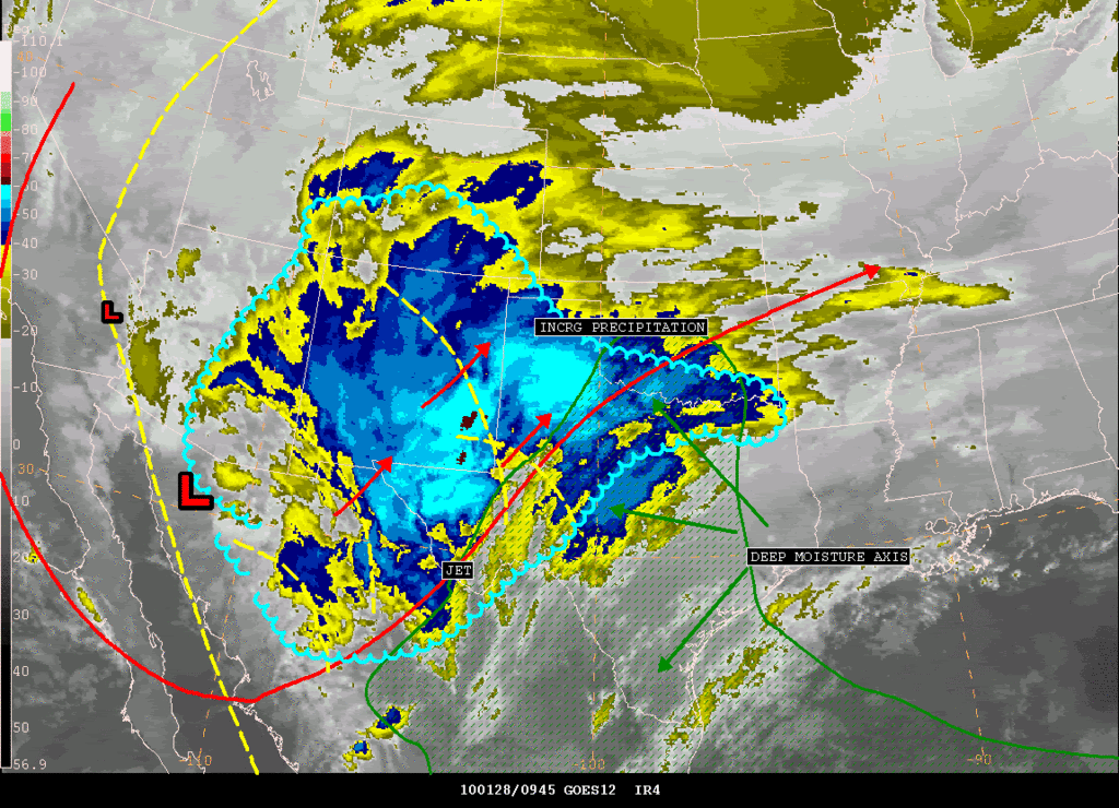
SATELLITE PRECIPITATION ESTIMATES..DATE/TIME 01/28/10 1010Z
SATELLITE ANALYSIS BRANCH/NESDIS---NPPU---TEL.301-763-8678
LATEST DATA USED: GOES-12/11 0945Z KUSSELSON
.
LOCATION...W TEXAS...OKLAHOMA...S COLORADO...NEW MEXICO...
LOCATION...ARIZONA...
.
ATTN WFOS...OUN...SJT...LUB...AMA...MAF...PUB...ABQ...EPZ...TWC...
ATTN RFCS...ABRFC...WGRFC...CBRFC...
.
EVENT...MOISTURE AND DYNAMICS ALL COMING TOGETHER...INCRG PRECIP NM TO
W TX TO OKLAHOMA...
.
SATELLITE ANALYSIS AND TRENDS...MAIN UPPER LOW BEGINNING TO SLOWLY OPEN
UP A BIT ACROSS NW OLD MEXICO AS SATELLITE WIND SPEED MAX OF NEAR 90KTS
COMES AROUND THE BOTTOM OF THE TROUGH (ACROSS W CENTRAL OLD MEXICO.)
THIS IN COMBO WITH VARIOUS SHORT WAVES COMING OUT AHEAD OF THE TROUGH
AND BLENDED TOTAL PRECIPITABLE WATER LOOP SHOWING AN EXPANSION OF DEEP
MOISTURE NORTH AND NW THRU TEXAS WILL HELP EXPLODE PRECIP TODAY ACROSS
W TEXAS INTO OKLAHOMA. IN THE IMMEDIATE FUTURE...COOLING CLOUD TOPS
SE NM INTO W CENTRAL TEXAS SETTING THE STAGE FOR INCRG PRECIP THERE THIS
MORNING AND A MAX PRECIP OF AN INCH OR MORE POSSIBLY CENTERED IN SW TO
W CENTRAL TEXAS FOR THE 12-18Z PERIOD AND THEN MIGRATING INTO OKLAHOMA
FOR THE 18-00Z ON THE WESTERN FRINGES OF THE ALREADY DEEPENING MOISTURE
AXIS THAT NOW WAS CENTERED FROM S CENTRAL TX TO S CENTRAL OK. AND IF
THAT WAS NOT ENOUGH...GPS SITES ACROSS THE AREA WERE ALREADY SHOWING
AN EXCELLENT PW MOISTURE GRADIENT FROM N CENTRAL TX (NEAR 1 INCH) TO
N CENTRAL OK WHERE PWATS WERE STEADY AT 0.4" WHICH SHOULD MAKE FOR AN
ADDITIONAL EXCELLENT OVERRUNNING AREA.
ON THE BACK SIDE OF LOW...WATER VAPOR LOOP SHOWING DARKENING ACROSS
S CA AND HANGBACK JET S CA INTO OLD MEXICO THAT COULD ALLOW FOR SOME
MOISTURE WRAP BACK IN AZ FOR MOST OF THE DAY...THERE MAY BE SOME TROWEL
CHARACTERISTICS DEVELOPING BACK THERE DURING THE DAY THAT WOULD FURTHER
CONFIRM THAT. UPPER SYSTEM NOW NEAR THE NW OLD MEXICO-S CENTRAL AZ
BORDER WILL BE SLOW MOVE EAST...SINCE NO REAL GOOD KICKER UPSTREAM IS
IDENTIFIED FOR THE NEXT 6HRS.
WILL CONTINUE TO MONITOR...SEE SATELLITE ANALYSIS GRAPHIC SHORTLY ON
HOME PAGE ADDRESS BELOW...
.
SEE NCEP HPC DISCUSSION AND QPF/S FOR FORECAST.
....NESDIS IS A MEMBER OF 12 PLANET....
.
SSD/SAB WEB ADDRESS FOR PRECIP ESTIMATES:
HTTP://WWW.SSD.NOAA.GOV/PS/PCPN/
...ALL LOWER CASE EXCEPT /PS/PCPN/

Image
0 likes   
Carla/Alicia/Jerry(In The Eye)/Michelle/Charley/Ivan/Dennis/Katrina/Rita/Wilma/Ike/Harvey

Member: National Weather Association
Wx Infinity Forums
http://wxinfinity.com/index.php

Facebook.com/WeatherInfinity
Twitter @WeatherInfinity


Return to “Winter Weather”

Who is online

Users browsing this forum: No registered users and 11 guests