
Atlantic Sea Surface Temperatures and Anomalies
Moderator: S2k Moderators
Forum rules

The posts in this forum are NOT official forecasts and should not be used as such. They are just the opinion of the poster and may or may not be backed by sound meteorological data. They are NOT endorsed by any professional institution or STORM2K. For official information, please refer to products from the National Hurricane Center and National Weather Service.
-
cycloneye

- Admin

- Posts: 149406
- Age: 69
- Joined: Thu Oct 10, 2002 10:54 am
- Location: San Juan, Puerto Rico
Re: Atlantic Sea Surface Temperatures and Anomalies
Yikes!! Take a look at how above normal are the sst anomalies in the MDR and Eastern Atlantic.If that stays as it is now,it will be a fuel to the parade of african waves that emerge that continent.This is the result of almost non-existant highs in the Atlantic thanks to the many big winter lows.
0 likes
Visit the Caribbean-Central America Weather Thread where you can find at first post web cams,radars
and observations from Caribbean basin members Click Here
and observations from Caribbean basin members Click Here
-
gatorcane

- S2K Supporter

- Posts: 23708
- Age: 48
- Joined: Sun Mar 13, 2005 3:54 pm
- Location: Boca Raton, FL
If you look at the anomalies in the Atlantic compared to last year at this time there is a significant difference. In fact the Atlantic MDR and Caribbean region are running warmer than 2004 and 2005 at this time, two very active years in recent past. Something to watch over the next several months especially if neutral conditions return as some of the models are forecasting.
Anomalies from this time last year (Feb. 19, 2009):

Anomalies currently:

Anomalies from this time last year (Feb. 19, 2009):
Anomalies currently:
0 likes
-
cycloneye
- Admin
- Posts: 149406
- Age: 69
- Joined: Thu Oct 10, 2002 10:54 am
- Location: San Juan, Puerto Rico
Re: Atlantic Sea Surface Temperatures and Anomalies
You can see the difference between the Tropical Cyclone Heat Potential in 2009 for Febuary 19 and this years graphic on the same date.More warmer TCHP this year.
http://www.aoml.noaa.gov/phod/cyclone/data/at.html
19th of Febuary,2009

19th of Febuary,2010

http://www.aoml.noaa.gov/phod/cyclone/data/at.html
19th of Febuary,2009
19th of Febuary,2010
0 likes
Visit the Caribbean-Central America Weather Thread where you can find at first post web cams,radars
and observations from Caribbean basin members Click Here
and observations from Caribbean basin members Click Here
-
cycloneye
- Admin
- Posts: 149406
- Age: 69
- Joined: Thu Oct 10, 2002 10:54 am
- Location: San Juan, Puerto Rico
Re: Atlantic Sea Surface Temperatures and Anomalies
MDR looks balmy for this time of the year.Lets see in the comming weeks how the anomalies go more warmer or decrease.
http://www.osdpd.noaa.gov/ml/ocean/sst/anomaly.html

http://www.osdpd.noaa.gov/ml/ocean/sst/anomaly.html
0 likes
Visit the Caribbean-Central America Weather Thread where you can find at first post web cams,radars
and observations from Caribbean basin members Click Here
and observations from Caribbean basin members Click Here
-
Blown Away

- S2K Supporter
- Posts: 10253
- Joined: Wed May 26, 2004 6:17 am
Re: Atlantic Sea Surface Temperatures and Anomalies
As cold as it has been here in SFL this El Nino winter it's amazing to see the MDR heating up! My thinking is this year we will see a CV monster become a problem for somebody in the E Caribbean and/or SE Conus! Hope not, but being in this active phase, 2010 analog years, warm MDR, and it's been quiet here in SFL for a few years, I feel SFL is due for a storm from the E.
0 likes
Hurricane Eye Experience: David 79, Irene 99, Frances 04, Jeanne 04, Wilma 05… Hurricane Brush Experience: Andrew 92, Erin 95, Floyd 99, Matthew 16, Irma 17, Ian 22, Nicole 22…


Re: Atlantic Sea Surface Temperatures and Anomalies
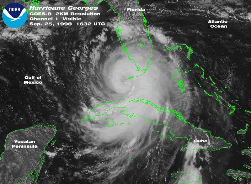
Though it is still too early to tell, I agree about a Cape Verde "monster" that will cause problems to US, Carbbean or Central America. If you look at the seasons that follow an El Niño year most of them have had destructive Cape Verde and Caribbean hurricanes. 1998 had Georges and Mitch, 2003 had Isabel, 2005 had Dennis and Wilma and 2007 had Dean and Felix.
0 likes
-
wxman57

- Moderator-Pro Met

- Posts: 23173
- Age: 68
- Joined: Sat Jun 21, 2003 8:06 pm
- Location: Houston, TX (southwest)
Re: Atlantic Sea Surface Temperatures and Anomalies
The reason the SSTs in the MDR are much warmer this year is directly related to the cold weather across the U.S. We had a strong negative NAO for quite a while. This means lower pressure off the East U.S. Coast and a weaker Bermuda High. Weaker Bermuda High means weaker easterly trade winds and less upwelling of cooler water. Last year, pressures across the Atlantic Basin were much higher, resulting in strong easterly trades, high low-level wind shear, and considerable dry air moving off the west coast of Africa.
It's all reversed this year. Look for a very busy season.
It's all reversed this year. Look for a very busy season.
0 likes

It'll be quite interesting to see how this summer behaves, the AO has been super negative this winter, more akin to the winters of the 60s.
I think the ENSO state really will hold the key to this season, every other factor looks good to go IMO for another busy season, like 1995/2003 and the ultimate extreme of 2005 (I refuse to use 1998 as that rapidly swang to a powerful La Nina that summer, however thats another one where everything set-up well after the El nino)
I also like 60s ENSO given the northern hemisphere this winter has been very much similar to the 60s in pattern, though obviously not as cold.
0 likes
Personal Forecast Disclaimer:
The posts in this forum are NOT official forecast and should not be used as such. They are just the opinion of the poster and may or may not be backed by sound meteorological data. They are NOT endorsed by any professional institution or storm2k.org. For official information, please refer to the NHC and NWS products
The posts in this forum are NOT official forecast and should not be used as such. They are just the opinion of the poster and may or may not be backed by sound meteorological data. They are NOT endorsed by any professional institution or storm2k.org. For official information, please refer to the NHC and NWS products

Re: Atlantic Sea Surface Temperatures and Anomalies
JB seems to agree. He cites 1964, 1998, 2005 & 2008 as analogs. Some active seasons. Too early to tell, but interesting to say the least.
http://www.accuweather.com/video-on-dem ... %20Lurking
http://www.accuweather.com/video-on-dem ... %20Lurking
0 likes
-
Cookie

- S2K Supporter
- Posts: 477
- Age: 38
- Joined: Sun Dec 14, 2008 11:13 am
- Location: Isle Of lewis scotland
Re: Atlantic Sea Surface Temperatures and Anomalies
blp wrote:JB seems to agree. He cites 1964, 1998, 2005 & 2008 as analogs. Some active seasons. Too early to tell, but interesting to say the least.
http://www.accuweather.com/video-on-dem ... %20Lurking
very interesting thanks for posting
0 likes
-
cycloneye
- Admin
- Posts: 149406
- Age: 69
- Joined: Thu Oct 10, 2002 10:54 am
- Location: San Juan, Puerto Rico
Re: Atlantic Sea Surface Temperatures and Anomalies
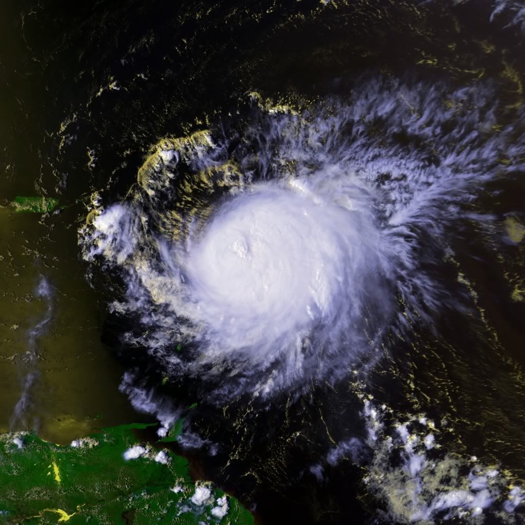
I cant imagine a repeat of 1998 because I dont want to experience something similar like this:

0 likes
Visit the Caribbean-Central America Weather Thread where you can find at first post web cams,radars
and observations from Caribbean basin members Click Here
and observations from Caribbean basin members Click Here
Re: Atlantic Sea Surface Temperatures and Anomalies
1998 was interesting in a meteorological point of view but it caused so much destruction in the Caribbean and Central America that nobody wants to experience it again, unfortuantely it seems that 1998 is a good analog especially if La Niña develops. Too early to tell but let's be prepared for anything.
0 likes
-
srainhoutx

- S2K Supporter
- Posts: 6919
- Age: 68
- Joined: Sun Jan 14, 2007 11:34 am
- Location: Haywood County, NC
- Contact:
Re: Atlantic Sea Surface Temperatures and Anomalies
cycloneye wrote:I cant imagine a repeat of 1998 because I dont want to experience something similar like this:
Last edited by srainhoutx on Thu Feb 25, 2010 7:25 pm, edited 1 time in total.
0 likes
Carla/Alicia/Jerry(In The Eye)/Michelle/Charley/Ivan/Dennis/Katrina/Rita/Wilma/Ike/Harvey
Member: National Weather Association
Wx Infinity Forums
http://wxinfinity.com/index.php
Facebook.com/WeatherInfinity
Twitter @WeatherInfinity
Member: National Weather Association
Wx Infinity Forums
http://wxinfinity.com/index.php
Facebook.com/WeatherInfinity
Twitter @WeatherInfinity
-
cycloneye
- Admin
- Posts: 149406
- Age: 69
- Joined: Thu Oct 10, 2002 10:54 am
- Location: San Juan, Puerto Rico
Re: Atlantic Sea Surface Temperatures and Anomalies
To continue with the 1998 analog discussion,here are how the anomalies were on Febuary 24,1998:

Here are the Febuary 25,2010 anomalies:

You can see the Tropical Atlantic between Africa and Lesser Antilles in above average sstas on both.
Here are the Febuary 25,2010 anomalies:
You can see the Tropical Atlantic between Africa and Lesser Antilles in above average sstas on both.
0 likes
Visit the Caribbean-Central America Weather Thread where you can find at first post web cams,radars
and observations from Caribbean basin members Click Here
and observations from Caribbean basin members Click Here
-
OuterBanker
- S2K Supporter
- Posts: 1761
- Joined: Wed Feb 26, 2003 10:53 am
- Location: Nags Head, NC
- Contact:
-
cycloneye
- Admin
- Posts: 149406
- Age: 69
- Joined: Thu Oct 10, 2002 10:54 am
- Location: San Juan, Puerto Rico
Re: Atlantic Sea Surface Temperatures and Anomalies
GOM is cold for the most part except in the loop current now,but watch with time how it will start to warm.

0 likes
Visit the Caribbean-Central America Weather Thread where you can find at first post web cams,radars
and observations from Caribbean basin members Click Here
and observations from Caribbean basin members Click Here
-
cycloneye
- Admin
- Posts: 149406
- Age: 69
- Joined: Thu Oct 10, 2002 10:54 am
- Location: San Juan, Puerto Rico
Re: Atlantic Sea Surface Temperatures and Anomalies
Its easy to see how warmer are the waters in 2010 compared to 2009 at the same date of Febuary 28.
Febuary 28,2009

Febuary 28,2010

Febuary 28,2009
Febuary 28,2010
0 likes
Visit the Caribbean-Central America Weather Thread where you can find at first post web cams,radars
and observations from Caribbean basin members Click Here
and observations from Caribbean basin members Click Here


Yep, Feb is almost certain to come in probably as warm in terms of the TNA as 2005, its certainly a rather worrying trend though there is still quite a lot of time for the SSTA to decrease, esp if we were to get a strengthening of the Azores high.
0 likes
Personal Forecast Disclaimer:
The posts in this forum are NOT official forecast and should not be used as such. They are just the opinion of the poster and may or may not be backed by sound meteorological data. They are NOT endorsed by any professional institution or storm2k.org. For official information, please refer to the NHC and NWS products
The posts in this forum are NOT official forecast and should not be used as such. They are just the opinion of the poster and may or may not be backed by sound meteorological data. They are NOT endorsed by any professional institution or storm2k.org. For official information, please refer to the NHC and NWS products
-
wxman57
- Moderator-Pro Met
- Posts: 23173
- Age: 68
- Joined: Sat Jun 21, 2003 8:06 pm
- Location: Houston, TX (southwest)
Re: Atlantic Sea Surface Temperatures and Anomalies
As we saw in 2009, SSTs are only part of the equation. If you remember, the Gulf of Mexico SSTs were well above normal, even higher than in 2005. Fortunately, wind shear was also high in the Gulf, so we saw no big storms. I'm afraid this year will be different in that the wind shear will likely be much lower than 2009, and not just because El Nino will be gone. It's the lower pressures in the MDR due to a weakened Bermuda High that are resulting in lower easterly trade winds and less low-level shear (and less dry air).
0 likes
Who is online
Users browsing this forum: No registered users and 99 guests