ENSO Updates (2007 thru 2023)
Moderator: S2k Moderators
Forum rules

The posts in this forum are NOT official forecasts and should not be used as such. They are just the opinion of the poster and may or may not be backed by sound meteorological data. They are NOT endorsed by any professional institution or STORM2K. For official information, please refer to products from the National Hurricane Center and National Weather Service.


Interestingly I'm not so sure anymore that the El nino will rapidly collapse, sure the SOI is positive and the subsurface is cold but there is no real upwelling occuring of the subsurface either at the moment and teleconnections are the moment aren't really favouring a rapid decline, but rather a slow decline towards neutral and perhaps cool neutral by October/November.
0 likes
Personal Forecast Disclaimer:
The posts in this forum are NOT official forecast and should not be used as such. They are just the opinion of the poster and may or may not be backed by sound meteorological data. They are NOT endorsed by any professional institution or storm2k.org. For official information, please refer to the NHC and NWS products
The posts in this forum are NOT official forecast and should not be used as such. They are just the opinion of the poster and may or may not be backed by sound meteorological data. They are NOT endorsed by any professional institution or storm2k.org. For official information, please refer to the NHC and NWS products
-
srainhoutx

- S2K Supporter

- Posts: 6919
- Age: 68
- Joined: Sun Jan 14, 2007 11:34 am
- Location: Haywood County, NC
- Contact:
Re:
KWT wrote:Interestingly I'm not so sure anymore that the El nino will rapidly collapse, sure the SOI is positive and the subsurface is cold but there is no real upwelling occuring of the subsurface either at the moment and teleconnections are the moment aren't really favouring a rapid decline, but rather a slow decline towards neutral and perhaps cool neutral by October/November.
Region 1+2 got your attention KWT?
0 likes
Carla/Alicia/Jerry(In The Eye)/Michelle/Charley/Ivan/Dennis/Katrina/Rita/Wilma/Ike/Harvey
Member: National Weather Association
Wx Infinity Forums
http://wxinfinity.com/index.php
Facebook.com/WeatherInfinity
Twitter @WeatherInfinity
Member: National Weather Association
Wx Infinity Forums
http://wxinfinity.com/index.php
Facebook.com/WeatherInfinity
Twitter @WeatherInfinity
-
cycloneye

- Admin

- Posts: 149155
- Age: 69
- Joined: Thu Oct 10, 2002 10:54 am
- Location: San Juan, Puerto Rico
Re: ENSO Updates=30 day SOI index keeps moving up=+10.7
El Nino 3.4 continues to go down slowly.

0 likes
Visit the Caribbean-Central America Weather Thread where you can find at first post web cams,radars
and observations from Caribbean basin members Click Here
and observations from Caribbean basin members Click Here
-
cycloneye
- Admin
- Posts: 149155
- Age: 69
- Joined: Thu Oct 10, 2002 10:54 am
- Location: San Juan, Puerto Rico
Re: ENSO Updates=30 day SOI index keeps moving up=+10.7
The ECMWF daily subsurface graphic shows how those warm waters slowly continue to wane while the cool waters expand.
http://www.ecmwf.int/products/forecasts ... me/xzmaps/
http://www.ecmwf.int/products/forecasts ... me/xzmaps/
0 likes
Visit the Caribbean-Central America Weather Thread where you can find at first post web cams,radars
and observations from Caribbean basin members Click Here
and observations from Caribbean basin members Click Here
-
cycloneye
- Admin
- Posts: 149155
- Age: 69
- Joined: Thu Oct 10, 2002 10:54 am
- Location: San Juan, Puerto Rico
Re: ENSO Updates=30 day SOI index keeps moving up=+12.0
The 30 day SOI index continues to make this impressive run upward,tonight's update up to +12.0.
http://www.bom.gov.au/climate/enso/soi.txt
http://www.longpaddock.qld.gov.au/Seaso ... SOIValues/

http://www.bom.gov.au/climate/enso/soi.txt
http://www.longpaddock.qld.gov.au/Seaso ... SOIValues/
0 likes
Visit the Caribbean-Central America Weather Thread where you can find at first post web cams,radars
and observations from Caribbean basin members Click Here
and observations from Caribbean basin members Click Here
-
cycloneye
- Admin
- Posts: 149155
- Age: 69
- Joined: Thu Oct 10, 2002 10:54 am
- Location: San Juan, Puerto Rico
Re: ENSO Updates=30 day SOI index keeps moving up=+12.0
I know that many members do not know what the heck SOI means  At link below you can read the whole explanation about what is this oscillation and how it can forecast when El Nino is waning and Neutral or La Nina comes to life or viceversa.
http://www.bom.gov.au/climate/glossary/soi.shtml
Sustained negative values of the SOI often indicate El Niño episodes. These negative values are usually accompanied by sustained warming of the central and eastern tropical Pacific Ocean, a decrease in the strength of the Pacific Trade Winds, and a reduction in rainfall over eastern and northern Australia. The most recent strong El Niño was in 1997/98, although its effect on Australia was rather limited. Severe droughts resulted from the weak to moderate El Niño events of 2002/03 and 2006/07.
Positive values of the SOI are associated with stronger Pacific trade winds and warmer sea temperatures to the north of Australia, popularly known as a La Niña episode. Waters in the central and eastern tropical Pacific Ocean become cooler during this time. Together these give an increased probability that eastern and northern Australia will be wetter than normal. The most recent strong La Niña was in 1988/89. A moderate La Niña developed slowly during 2007.
0 likes
Visit the Caribbean-Central America Weather Thread where you can find at first post web cams,radars
and observations from Caribbean basin members Click Here
and observations from Caribbean basin members Click Here
It also should be added that the SOI can show some big disconnection from the ENSO state over small periods of time, for example in the 2006 El nino the SOI stayed positive right upto the start of the decay of the El nino when it finally flipped.
0 likes
Personal Forecast Disclaimer:
The posts in this forum are NOT official forecast and should not be used as such. They are just the opinion of the poster and may or may not be backed by sound meteorological data. They are NOT endorsed by any professional institution or storm2k.org. For official information, please refer to the NHC and NWS products
The posts in this forum are NOT official forecast and should not be used as such. They are just the opinion of the poster and may or may not be backed by sound meteorological data. They are NOT endorsed by any professional institution or storm2k.org. For official information, please refer to the NHC and NWS products


Re: ENSO Updates=30 day SOI index keeps moving up=+12.0
KWT wrote:It also should be added that the SOI can show some big disconnection from the ENSO state over small periods of time, for example in the 2006 El nino the SOI stayed positive right upto the start of the decay of the El nino when it finally flipped.
This is entirely true; last summer showed that pretty well.
However, in general, there is remarkable correlation, and the high SOIs at least mean no more Kelvin waves for now, which are what has been keeping this Nino going. In the last 3 days, Nino 1+2 looks to have cooled back down a decent amount, as the central pacific warm anomalies continue to slowly degrade.
http://www.osdpd.noaa.gov/ml/ocean/sst/anom_anim.html
0 likes
-
cycloneye
- Admin
- Posts: 149155
- Age: 69
- Joined: Thu Oct 10, 2002 10:54 am
- Location: San Juan, Puerto Rico
Re: ENSO Updates=30 day SOI index keeps moving up=+12.0
The cool subsurface waters slowly but surely continue to expand.
Daily Subsurface update by ECMWF on April 22
Daily Subsurface update by ECMWF on April 22
0 likes
Visit the Caribbean-Central America Weather Thread where you can find at first post web cams,radars
and observations from Caribbean basin members Click Here
and observations from Caribbean basin members Click Here
-
cycloneye
- Admin
- Posts: 149155
- Age: 69
- Joined: Thu Oct 10, 2002 10:54 am
- Location: San Juan, Puerto Rico
Re: ENSO Updates=30 day SOI index keeps moving up=+13.3
Tonight's update of the SOI continues its movement up,now to +13.3. With this sharp climb of the SOI,we are seeing the very last stage of what may be left of El Nino.
20100322,20100420,12.0
20100323,20100421,13.3
20100322,20100420,12.0
20100323,20100421,13.3
0 likes
Visit the Caribbean-Central America Weather Thread where you can find at first post web cams,radars
and observations from Caribbean basin members Click Here
and observations from Caribbean basin members Click Here
-
cycloneye
- Admin
- Posts: 149155
- Age: 69
- Joined: Thu Oct 10, 2002 10:54 am
- Location: San Juan, Puerto Rico
Re: ENSO Updates=30 day SOI index keeps moving up=+13.3
The upward movement of the 30 day SOI may come to a halt in tonight's update as the daily data has come down.
http://www.longpaddock.qld.gov.au/Seaso ... SOIValues/
http://www.longpaddock.qld.gov.au/Seaso ... SOIValues/
0 likes
Visit the Caribbean-Central America Weather Thread where you can find at first post web cams,radars
and observations from Caribbean basin members Click Here
and observations from Caribbean basin members Click Here
-
cycloneye
- Admin
- Posts: 149155
- Age: 69
- Joined: Thu Oct 10, 2002 10:54 am
- Location: San Juan, Puerto Rico
Re: ENSO Updates
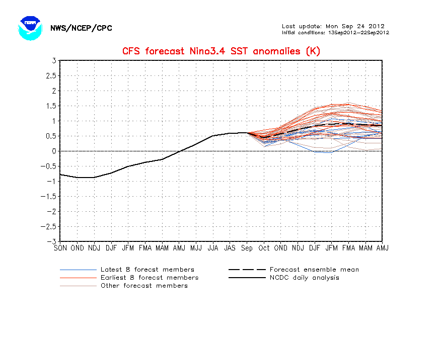
The CFS model has not changed much from its past forecast of Neutral ENSO by late May or early June.But the change comes later as the model goes to La Nina more earlier than in the past weeks.
0 likes
Visit the Caribbean-Central America Weather Thread where you can find at first post web cams,radars
and observations from Caribbean basin members Click Here
and observations from Caribbean basin members Click Here
Re: ENSO Updates
cycloneye wrote:April 23 Daily Subsurface Graphic
Looks to me that when/if that little tongue around 145 west gets to the surface, it will break the back of the remaining el nino.
0 likes
Certainly interesting to see, though the CFS is still less agressive than the ECM which goes into moderate range with quite a few members of the ensemble...
I still think La Nina maybe a little optimistic...we shall see!
I still think La Nina maybe a little optimistic...we shall see!
0 likes
Personal Forecast Disclaimer:
The posts in this forum are NOT official forecast and should not be used as such. They are just the opinion of the poster and may or may not be backed by sound meteorological data. They are NOT endorsed by any professional institution or storm2k.org. For official information, please refer to the NHC and NWS products
The posts in this forum are NOT official forecast and should not be used as such. They are just the opinion of the poster and may or may not be backed by sound meteorological data. They are NOT endorsed by any professional institution or storm2k.org. For official information, please refer to the NHC and NWS products
-
Blown Away

- S2K Supporter
- Posts: 10253
- Joined: Wed May 26, 2004 6:17 am
Re: ENSO Updates
What's a good analog year when there was a transition from neutral to La Nina during the heart of the hurricane season?
0 likes
Hurricane Eye Experience: David 79, Irene 99, Frances 04, Jeanne 04, Wilma 05… Hurricane Brush Experience: Andrew 92, Erin 95, Floyd 99, Matthew 16, Irma 17, Ian 22, Nicole 22…
If we go La Nina I'd imagine 1998 and 2007 would be the best recent examples. 1995 became weak La Nina by Autumn as well.
0 likes
Personal Forecast Disclaimer:
The posts in this forum are NOT official forecast and should not be used as such. They are just the opinion of the poster and may or may not be backed by sound meteorological data. They are NOT endorsed by any professional institution or storm2k.org. For official information, please refer to the NHC and NWS products
The posts in this forum are NOT official forecast and should not be used as such. They are just the opinion of the poster and may or may not be backed by sound meteorological data. They are NOT endorsed by any professional institution or storm2k.org. For official information, please refer to the NHC and NWS products
-
wxman57

- Moderator-Pro Met

- Posts: 23170
- Age: 68
- Joined: Sat Jun 21, 2003 8:06 pm
- Location: Houston, TX (southwest)
Re: ENSO Updates
Check past seasons' ENSO values here:
http://www.cpc.noaa.gov/products/analys ... ears.shtml
2005 would be a good analog, too. And the SST pattern in the Atlantic is most similar to 2005.
http://www.cpc.noaa.gov/products/analys ... ears.shtml
2005 would be a good analog, too. And the SST pattern in the Atlantic is most similar to 2005.
0 likes
1958 would be a good one as well IMO given the El Nino winter and the SST's being well above average, though that season the El nino only very slowly decayed into the summer.
0 likes
Personal Forecast Disclaimer:
The posts in this forum are NOT official forecast and should not be used as such. They are just the opinion of the poster and may or may not be backed by sound meteorological data. They are NOT endorsed by any professional institution or storm2k.org. For official information, please refer to the NHC and NWS products
The posts in this forum are NOT official forecast and should not be used as such. They are just the opinion of the poster and may or may not be backed by sound meteorological data. They are NOT endorsed by any professional institution or storm2k.org. For official information, please refer to the NHC and NWS products
-
Blown Away
- S2K Supporter
- Posts: 10253
- Joined: Wed May 26, 2004 6:17 am
Re:
KWT wrote:1958 would be a good one as well IMO given the El Nino winter and the SST's being well above average, though that season the El nino only very slowly decayed into the summer.

Lots if fishies if 1958 happens, seems like a good analog due to the above average MDR SST's and predicted weaker BH. Maybe we will see more storms develope farther E resulting in more recurves??
0 likes
Hurricane Eye Experience: David 79, Irene 99, Frances 04, Jeanne 04, Wilma 05… Hurricane Brush Experience: Andrew 92, Erin 95, Floyd 99, Matthew 16, Irma 17, Ian 22, Nicole 22…
Who is online
Users browsing this forum: cycloneye and 92 guests