Next round of severe weather 7th May Onwards?

U.S. & Caribbean Weather Discussions and Severe Weather Events

Moderator: S2k Moderators

Forum rules

The posts in this forum are NOT official forecast and should not be used as such. They are just the opinion of the poster and may or may not be backed by sound meteorological data. They are NOT endorsed by any professional institution or STORM2K.

Help Support Storm2K
Message
Author
RL3AO
Moderator-Pro Met
Moderator-Pro Met
Posts: 16308
Joined: Thu Jun 14, 2007 10:03 pm
Location: NC

#61 Postby RL3AO » Sun May 09, 2010 8:50 pm

7pm Wichita Falls NAM sounding.

Image

Yikes.
0 likes   

6SpeedTA95
Category 5
Category 5
Posts: 1206
Joined: Wed Oct 19, 2005 3:25 pm
Location: Oklahoma
Contact:

Re:

#62 Postby 6SpeedTA95 » Sun May 09, 2010 9:34 pm

RL3AO wrote:7pm Wichita Falls NAM sounding.

Image

Yikes.

Wow...the HODO is equally impressive.`
0 likes   

6SpeedTA95
Category 5
Category 5
Posts: 1206
Joined: Wed Oct 19, 2005 3:25 pm
Location: Oklahoma
Contact:

#63 Postby 6SpeedTA95 » Sun May 09, 2010 10:17 pm

I think 11:30am cdt might be the upgrade to high risk.

The 00Z nam is substantially different than the 12z or 18z.
0 likes   

User avatar
wx247
S2K Supporter
S2K Supporter
Posts: 14279
Age: 41
Joined: Wed Feb 05, 2003 10:35 pm
Location: Monett, Missouri
Contact:

Re:

#64 Postby wx247 » Sun May 09, 2010 10:23 pm

6SpeedTA95 wrote:I think 11:30am cdt might be the upgrade to high risk.

The 00Z nam is substantially different than the 12z or 18z.


I haven't had a chance to thoroughly look at it. What's your take on it?
0 likes   
Personal Forecast Disclaimer:
The posts in this forum are NOT official forecast and should not be used as such. They are just the opinion of the poster and may or may not be backed by sound meteorological data. They are NOT endorsed by any professional institution or storm2k.org. For official information, please refer to the NHC and NWS products.

johnmarkthom
Tropical Low
Tropical Low
Posts: 24
Joined: Wed Apr 21, 2010 7:47 am
Location: Joplin, MO

Re: Next round of severe weather 7th May Onwards?

#65 Postby johnmarkthom » Mon May 10, 2010 2:30 am

Uh-Oh Upgrade to High Risk SE KS and NE OK
0 likes   

User avatar
somethingfunny
ChatStaff
ChatStaff
Posts: 3926
Age: 36
Joined: Thu May 31, 2007 10:30 pm
Location: McKinney, Texas

Re: Next round of severe weather 7th May Onwards?

#66 Postby somethingfunny » Mon May 10, 2010 4:34 am

Oh wow. Strange that we're not even expecting rain here in DFW.
0 likes   

User avatar
wx247
S2K Supporter
S2K Supporter
Posts: 14279
Age: 41
Joined: Wed Feb 05, 2003 10:35 pm
Location: Monett, Missouri
Contact:

#67 Postby wx247 » Mon May 10, 2010 6:20 am

Here is a graphical look at the threat area as of 6 am central time this morning:

Image
0 likes   
Personal Forecast Disclaimer:
The posts in this forum are NOT official forecast and should not be used as such. They are just the opinion of the poster and may or may not be backed by sound meteorological data. They are NOT endorsed by any professional institution or storm2k.org. For official information, please refer to the NHC and NWS products.

User avatar
KWT
Category 5
Category 5
Posts: 31415
Joined: Tue Aug 17, 2004 11:02 am
Location: UK!!!

#68 Postby KWT » Mon May 10, 2010 7:14 am

A fairly early upgrade to a high risk event but not all that surprising.

Going to be a long eveing/night once the cap does break.
0 likes   
Personal Forecast Disclaimer:
The posts in this forum are NOT official forecast and should not be used as such. They are just the opinion of the poster and may or may not be backed by sound meteorological data. They are NOT endorsed by any professional institution or storm2k.org. For official information, please refer to the NHC and NWS products

Mindi
Tropical Wave
Tropical Wave
Posts: 9
Joined: Sat May 01, 2010 4:40 pm
Location: Nixa, MO

Re: Next round of severe weather 7th May Onwards?

#69 Postby Mindi » Mon May 10, 2010 7:15 am

Any estimation of when the cap might break?
0 likes   

User avatar
cycloneye
Admin
Admin
Posts: 143898
Age: 68
Joined: Thu Oct 10, 2002 10:54 am
Location: San Juan, Puerto Rico

Re: Next round of severe weather 7th May Onwards?

#70 Postby cycloneye » Mon May 10, 2010 7:41 am

Here is the Accuweather discussion video about this event.

http://www.accuweather.com/video.asp
0 likes   
Visit the Caribbean-Central America Weather Thread where you can find at first post web cams,radars
and observations from Caribbean basin members Click Here

User avatar
KWT
Category 5
Category 5
Posts: 31415
Joined: Tue Aug 17, 2004 11:02 am
Location: UK!!!

Re: Next round of severe weather 7th May Onwards?

#71 Postby KWT » Mon May 10, 2010 7:52 am

Mindi wrote:Any estimation of when the cap might break?


Hard to call, some models show some stormsm trying to break out as early as the mid afternoon but there is some big uncertainties still with this evolution...
0 likes   
Personal Forecast Disclaimer:
The posts in this forum are NOT official forecast and should not be used as such. They are just the opinion of the poster and may or may not be backed by sound meteorological data. They are NOT endorsed by any professional institution or storm2k.org. For official information, please refer to the NHC and NWS products

CrazyC83
Professional-Met
Professional-Met
Posts: 34001
Joined: Tue Mar 07, 2006 11:57 pm
Location: Deep South, for the first time!

#72 Postby CrazyC83 » Mon May 10, 2010 8:33 am

I would guess late afternoon for the cap breaking - maybe around 4 pm local time.
0 likes   

CrazyC83
Professional-Met
Professional-Met
Posts: 34001
Joined: Tue Mar 07, 2006 11:57 pm
Location: Deep South, for the first time!

Re: Next round of severe weather 7th May Onwards?

#73 Postby CrazyC83 » Mon May 10, 2010 10:13 am

Current conditions in the threat area - as of 9:00 am CDT

Arkansas
Fayetteville - Overcast, 54 (52)
Fort Smith - Overcast, 54 (51)

Kansas
Chanute - Light rain, 50 (48)
Emporia - Overcast, 50 (47)
Hays - Overcast, 52 (48)
Pratt - Overcast, 52 (52)
Salina - Overcast, 51 (49)
Topeka - Light rain, 50 (48)
Wichita - Drizzle, 52 (51)

Missouri
Joplin - Overcast, 51 (47)
Kansas City - Overcast, 49 (45)
Sedalia - Light rain, 49 (45)
Springfield - Overcast, 49 (46)

Oklahoma
Altus - Mostly cloudy, 68 (64)
Ardmore - Mostly cloudy, 66 (63)
Bartlesville - Overcast, 54 (52)
Clinton - Overcast, 62 (60)
Enid - Fog, 58 (58)
Lawton - Mostly cloudy, 69 (64)
McAlester - Mostly cloudy, 63 (58)
Muskogee - Overcast, 55 (53)
Oklahoma City - Overcast, 64 (61)
Stillwater - Overcast, 58 (56)
Tulsa - Overcast, 55 (53)
Woodward - Overcast, 62 (58)

Texas
Abilene - Partly cloudy, 75 (63)
Dallas - Partly cloudy, 76 (67)
Fort Worth - Mostly cloudy, 77 (67)
Sherman - Mostly cloudy, 67 (63)
Wichita Falls - Mostly cloudy, 72 (64)
0 likes   

Ntxwx
Tropical Storm
Tropical Storm
Posts: 153
Joined: Tue Jan 26, 2010 10:43 am
Location: Bridgeport, Texas

Re:

#74 Postby Ntxwx » Mon May 10, 2010 10:20 am

CrazyC83 wrote:I would guess late afternoon for the cap breaking - maybe around 4 pm local time.


My guess is 4:00 pm as well.
0 likes   

User avatar
brunota2003
S2K Supporter
S2K Supporter
Posts: 9476
Age: 34
Joined: Sat Jul 30, 2005 9:56 pm
Location: Stanton, KY...formerly Havelock, NC
Contact:

#75 Postby brunota2003 » Mon May 10, 2010 10:27 am

Certainly looks like central Oklahoma will be the main area today. Will be looking for storms to develop around the Lawton/Ft. Sill area and probably rapidly go tornado warned as they head to the NE. Enid, OKC, and Tulsa look to be under the gun, then the cells will shift quickly to the NE by nightfall.

What do y'all think?
Last edited by brunota2003 on Mon May 10, 2010 10:36 am, edited 1 time in total.
0 likes   

Ntxwx
Tropical Storm
Tropical Storm
Posts: 153
Joined: Tue Jan 26, 2010 10:43 am
Location: Bridgeport, Texas

Re: Next round of severe weather 7th May Onwards?

#76 Postby Ntxwx » Mon May 10, 2010 10:32 am

I belive the caping inversion could potentially give in in North Texas, although the main threat for this system, as been previoulsy stated remains further north in the MDT and High Risk zones from OKC eastward toward Tulsa and southeast Kansas.
0 likes   

User avatar
srainhoutx
S2K Supporter
S2K Supporter
Posts: 6919
Age: 67
Joined: Sun Jan 14, 2007 11:34 am
Location: Haywood County, NC
Contact:

Re: Next round of severe weather 7th May Onwards?

#77 Postby srainhoutx » Mon May 10, 2010 10:55 am

Image

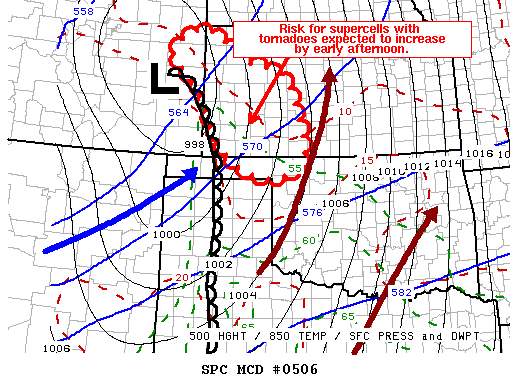
MESOSCALE DISCUSSION 0506
NWS STORM PREDICTION CENTER NORMAN OK
1037 AM CDT MON MAY 10 2010

AREAS AFFECTED...PARTS OF EXTREME ERN CO...WRN KS INTO NW OK

CONCERNING...SEVERE POTENTIAL...WATCH LIKELY

VALID 101537Z - 101730Z

TRENDS ARE BEING MONITORED FOR AN INCREASING SEVERE THREAT AND THE
POSSIBILITY OF A WW...WHICH SEEMS LIKELY TO BE NEEDED AROUND 17-18Z.


LATEST OBSERVATIONAL DATA AND RUC GUIDANCE INDICATE THAT A 90+ KT
CYCLONIC 500 MB JET STREAK IS ALREADY IN THE PROCESS OF NOSING EAST
OF THE SOUTHERN ROCKIES INTO/THROUGH THE TEXAS PANHANDLE REGION.
THIS IS EXPECTED TO BE ACCOMPANIED BY STRENGTHENING MID/UPPER
FORCING FOR UPWARD VERTICAL MOTION SPREADING EAST OF THE ROCKIES
THROUGH THE CENTRAL HIGH PLAINS BETWEEN NOW AND EARLY
AFTERNOON...WHICH LIKELY WILL CONTRIBUTE TO STEEPENING LAPSE RATES
AND MODERATELY STRONG CAPE AS SURFACE HEATING PROGRESSES. THE
DEVELOPING DRY LINE NEAR A DEEP SURFACE LOW PROGGED TO MIGRATE
SOUTHEASTWARD OUT OF EAST CENTRAL COLORADO INTO SOUTHWEST KANSAS IS
EXPECTED TO BECOME THE FOCUS FOR STRONG DESTABILIZATION ...AND STORM
INITIATION...POSSIBLY AS EARLY AS THE 17-19Z TIME FRAME. DEEP LAYER
SHEAR IS ALREADY MORE THAN SUFFICIENT FOR SUPERCELLS...AND THOUGH
SOUTHERLY LOW-LEVEL FLOW FIELDS MAY REMAIN SOMEWHAT
MODEST...CLOCKWISE LOW-LEVEL HODOGRAPH CURVATURE/ INCREASING AMBIENT
VERTICAL VORTICITY AND BOUNDARY LAYER DESTABILIZATION WILL PROBABLY
BECOME CONDUCIVE FOR TORNADOES...IN ADDITION TO LARGE HAIL.

..KERR.. 05/10/2010


ATTN...WFO...OUN...DDC...GLD...AMA...PUB...
0 likes   
Carla/Alicia/Jerry(In The Eye)/Michelle/Charley/Ivan/Dennis/Katrina/Rita/Wilma/Ike/Harvey

Member: National Weather Association
Wx Infinity Forums
http://wxinfinity.com/index.php

Facebook.com/WeatherInfinity
Twitter @WeatherInfinity

User avatar
wx247
S2K Supporter
S2K Supporter
Posts: 14279
Age: 41
Joined: Wed Feb 05, 2003 10:35 pm
Location: Monett, Missouri
Contact:

#78 Postby wx247 » Mon May 10, 2010 10:57 am

I noticed clouds are beginning to erode across Southern Oklahoma. This is behind the warm front. We shall see how much northward progress the front makes.
0 likes   
Personal Forecast Disclaimer:
The posts in this forum are NOT official forecast and should not be used as such. They are just the opinion of the poster and may or may not be backed by sound meteorological data. They are NOT endorsed by any professional institution or storm2k.org. For official information, please refer to the NHC and NWS products.

johnmarkthom
Tropical Low
Tropical Low
Posts: 24
Joined: Wed Apr 21, 2010 7:47 am
Location: Joplin, MO

Re: Next round of severe weather 7th May Onwards?

#79 Postby johnmarkthom » Mon May 10, 2010 11:43 am

Doesn't look like much has changed with the 11:00 update from the SPC.
0 likes   

CrazyC83
Professional-Met
Professional-Met
Posts: 34001
Joined: Tue Mar 07, 2006 11:57 pm
Location: Deep South, for the first time!

#80 Postby CrazyC83 » Mon May 10, 2010 12:10 pm

Current conditions in the threat area - as of 12:00 pm CDT

Arkansas
Fayetteville - Overcast, 57 (54)
Fort Smith - Light rain, 56 (53)

Kansas
Chanute - Overcast, 54 (51)
Dodge City - Overcast, 58 (57)
Emporia - Overcast, 52 (49)
Garden City - Overcast, 63 (60)
Goodland - Fog, 55 (54)
Hays - Overcast, 54 (52)
Pratt - Overcast, 55 (54)
Salina - Overcast, 51 (49)
Topeka - Light rain, 51 (49)
Wichita - Drizzle, 55 (55)

Missouri
Joplin - Overcast, 55 (50)
Kansas City - Rain, 48 (46)
Sedalia - Thunderstorm, 50 (48)
Springfield - Overcast, 49 (47)

Oklahoma
Altus - Clear, 81 (67)
Ardmore - Mostly cloudy, 70 (64)
Bartlesville - Overcast, 57 (55)
Clinton - A few clouds, 75 (64)
Enid - Overcast, 65 (65)
Lawton - Mostly cloudy, 77 (67)
McAlester - Mostly cloudy, 66 (61)
Muskogee - Mostly cloudy, 59 (55)
Oklahoma City - Mostly cloudy, 66 (62)
Stillwater - Mostly cloudy, 64 (60)
Tulsa - Mostly cloudy, 59 (56)
Woodward - Partly cloudy, 72 (61)

Texas
Abilene - A few clouds, 84 (67)
Dallas - Mostly cloudy, 80 (67)
Fort Worth - Partly cloudy, 81 (67)
Sherman - Mostly cloudy, 74 (67)
Wichita Falls - Partly cloudy, 82 (66)
0 likes   


Return to “USA & Caribbean Weather”

Who is online

Users browsing this forum: No registered users and 60 guests