ATL: EX-Tropical Depression FIVE - Discussion
Moderator: S2k Moderators
-
KFDM Meteorologist

- Professional-Met

- Posts: 1314
- Joined: Tue May 16, 2006 9:52 pm
- Location: Upper Texas Coast/Orange County
-
Dean4Storms
- S2K Supporter

- Posts: 6358
- Age: 63
- Joined: Sun Aug 31, 2003 1:01 pm
- Location: Miramar Bch. FL
AREA FORECAST DISCUSSION
NATIONAL WEATHER SERVICE TALLAHASSEE FL
1030 AM EDT SAT AUG 14 2010
.UPDATE...THE MORNING SURFACE ANALYSIS SHOWED THE REMNANT
CIRCULATION FROM TD5 CENTERED JUST NORTH OF THE LOCAL IN EAST-
CENTRAL ALABAMA AND THE SUBTROPICAL RIDGE AXIS SOUTH OF THE AREA
EXTENDING WEST OVER THE CENTRAL GULF OF MEXICO. DEEP MOIST
SOUTHWEST FLOW COMBINED WITH ENHANCED LOW-LEVEL CONVERGENCE INTO
A WEAK SURFACE TROUGH EXTENDING SOUTH FROM THE CIRCULATION WILL
KEEP THE RAIN CHANCES UP THROUGH THE DAY (VERY SIMILAR TO
YESTERDAY). THE LATEST REGIONAL RADAR LOOP AND OBSERVATIONS DIDN`T
INDICATE MUCH OF ANY RECENT NORTHWARD PROGRESSION OF THIS
LOW...MAINLY A SLOW EAST DRIFT TOWARD THE GA/AL STATE LINE. THE
MODELS HAVE INITIALIZED WELL WITH THIS POSITION AND TREND AND SHOW
IT BEGINNING TO TRACK SOUTH BACK TOWARD THE LOCAL AREA THROUGH THE
AFTERNOON AND EVENING HOURS TODAY. SOME MINOR ADJUSTMENTS WERE
MADE TO THE POP/QPF/SKY GRID CONFIGURATION BASED ON THESE LATEST
TRENDS THIS MORNING. OTHERWISE...THE PREVIOUS PACKAGE REMAINS ON
TRACK.
0 likes


Re: Re:
Dean4Storms wrote:Don't know what you're seeing that would make you think that. The MLC appears to be now moving into West Central GA which means the EURO could be correct in bringing it offshore further east around Appalachicola.
Speed up the animation, you can clearly see it moving into GA.
http://www.rap.ucar.edu/weather/satelli ... duration=6
Just looking at most of the models progging this one reaches the coast and then trends westwards along the coast. The ECM probably the most southerly of the models thought really there is only small differences.
I've said all along though Dean if it makes it into the water, even if only by 5-10 miles it'll probably be enough for the chances of this one to redevelop to shot up.
0 likes
Personal Forecast Disclaimer:
The posts in this forum are NOT official forecast and should not be used as such. They are just the opinion of the poster and may or may not be backed by sound meteorological data. They are NOT endorsed by any professional institution or storm2k.org. For official information, please refer to the NHC and NWS products
The posts in this forum are NOT official forecast and should not be used as such. They are just the opinion of the poster and may or may not be backed by sound meteorological data. They are NOT endorsed by any professional institution or storm2k.org. For official information, please refer to the NHC and NWS products
-
Dean4Storms
- S2K Supporter
- Posts: 6358
- Age: 63
- Joined: Sun Aug 31, 2003 1:01 pm
- Location: Miramar Bch. FL
Re: Re:
KWT wrote:Dean4Storms wrote:Don't know what you're seeing that would make you think that. The MLC appears to be now moving into West Central GA which means the EURO could be correct in bringing it offshore further east around Appalachicola.
Speed up the animation, you can clearly see it moving into GA.
http://www.rap.ucar.edu/weather/satelli ... duration=6
Just looking at most of the models progging this one reaches the coast and then trends westwards along the coast. The ECM probably the most southerly of the models thought really there is only small differences.
I've said all along though Dean if it makes it into the water, even if only by 5-10 miles it'll probably be enough for the chances of this one to redevelop to shot up.
I expect it to get back over the water if not relocated after a strong convective burst offshore overnight Sunday night. Keep in mind this low will be broad and any deep convection offshore should be able to consolidate a low fairly quickly with these warm SST's and a quite favorable UL environment.
0 likes

Re: Models Develop Gulf System - EX-TD5 Thread
Looking at this radar, EX TD 5 is better defined than yesterday IMHO. But it's still heading Northeast or east northeast. I can't see it making this big loop and getting back in the GOM or along the coast but with all the model support I guess I'll be wrong again.
Uncheck all the boxes below the radar except, radar and you can easy track the circulation you can even zoom in tight.
http://radar.weather.gov/radar.php?rid= ... 0&loop=yes
Uncheck all the boxes below the radar except, radar and you can easy track the circulation you can even zoom in tight.
http://radar.weather.gov/radar.php?rid= ... 0&loop=yes
0 likes
The following post is NOT an official forecast and should not be used as such. It is just the opinion of the poster and may or may not be backed by sound meteorological data. It is NOT endorsed by any professional institution including storm2k.org For Official Information please refer to the NHC and NWS products.
-
vbhoutex

- Storm2k Executive

- Posts: 29149
- Age: 74
- Joined: Wed Oct 09, 2002 11:31 pm
- Location: Cypress, TX
- Contact:
Re: Models Develop Gulf System - EX-TD5 Thread
0 likes
Skywarn, C.E.R.T.
Please click below to donate to STORM2K to help with the expenses of keeping the site going:

Please click below to donate to STORM2K to help with the expenses of keeping the site going:
That radar looks like its moving perhaps just a little north of east, best start moving southwards soon if its going to get into the Gulf though from the looks of things.
0 likes
Personal Forecast Disclaimer:
The posts in this forum are NOT official forecast and should not be used as such. They are just the opinion of the poster and may or may not be backed by sound meteorological data. They are NOT endorsed by any professional institution or storm2k.org. For official information, please refer to the NHC and NWS products
The posts in this forum are NOT official forecast and should not be used as such. They are just the opinion of the poster and may or may not be backed by sound meteorological data. They are NOT endorsed by any professional institution or storm2k.org. For official information, please refer to the NHC and NWS products
-
Pearl River

- S2K Supporter
- Posts: 825
- Age: 67
- Joined: Fri Dec 09, 2005 6:07 pm
- Location: SELa
Re: Models Develop Gulf System - EX-TD5 Thread
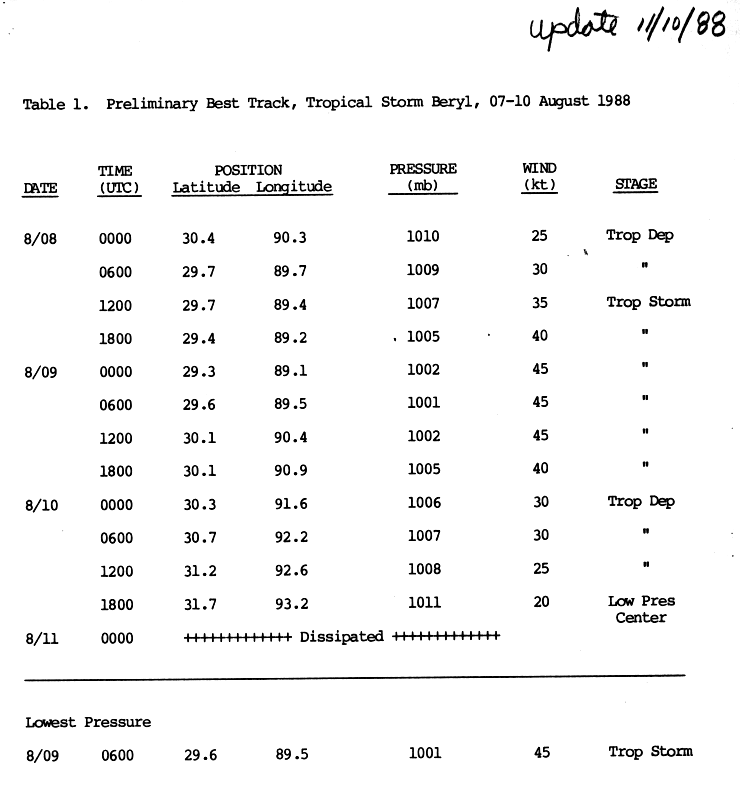
http://www.nhc.noaa.gov/archive/storm_wallets/atlantic/atl1988-prelim/beryl/prelim05.gif
Here's a little tidbit. Beryl 1988 started as a depression over land then moved southeast to the mouth of the Mississippi where she became a storm. Even if it moves south and hugs the coast, it could develop, not saying it will, but it's interesting.
Here's a little tidbit. Beryl 1988 started as a depression over land then moved southeast to the mouth of the Mississippi where she became a storm. Even if it moves south and hugs the coast, it could develop, not saying it will, but it's interesting.
0 likes
Certainly could PR, I'm keeping a close eye on it because if it gets to the coast then given the current presentation it'd have a chance of redeveloping again.
0 likes
Personal Forecast Disclaimer:
The posts in this forum are NOT official forecast and should not be used as such. They are just the opinion of the poster and may or may not be backed by sound meteorological data. They are NOT endorsed by any professional institution or storm2k.org. For official information, please refer to the NHC and NWS products
The posts in this forum are NOT official forecast and should not be used as such. They are just the opinion of the poster and may or may not be backed by sound meteorological data. They are NOT endorsed by any professional institution or storm2k.org. For official information, please refer to the NHC and NWS products
-
MiamiHurricanes10

- S2K Supporter
- Posts: 260
- Joined: Mon Jul 19, 2010 7:56 pm
- Location: Miami, Florida
Re: Models Develop Gulf System - EX-TD5 Thread
vbhoutex wrote:This one has been/is going to be interesting to watch..
Yeah I agree with that, the whole set-up is quite an interesting one to watch, esp because the mid level circulation has held very strong, indeed it may even be stronger now then it was when it was in the Gulf for most of the time.
0 likes
Personal Forecast Disclaimer:
The posts in this forum are NOT official forecast and should not be used as such. They are just the opinion of the poster and may or may not be backed by sound meteorological data. They are NOT endorsed by any professional institution or storm2k.org. For official information, please refer to the NHC and NWS products
The posts in this forum are NOT official forecast and should not be used as such. They are just the opinion of the poster and may or may not be backed by sound meteorological data. They are NOT endorsed by any professional institution or storm2k.org. For official information, please refer to the NHC and NWS products
-
MGC

- S2K Supporter
- Posts: 5940
- Joined: Sun Mar 23, 2003 9:05 pm
- Location: Pass Christian MS, or what is left.
Re: Models Develop Gulf System - EX-TD5 Thread
This kinda reminds me of Ivan in 2004 if this happens.....MGC
0 likes

Re: Models Develop Gulf System - EX-TD5 Thread
I'm beginning to wonder if the TD5 remnants are going to have any interaction with the tail end of the front off the east coast of Florida. Lots of disorganized convection over there.
0 likes
-
Stormcenter
- S2K Supporter
- Posts: 6689
- Joined: Wed Sep 03, 2003 11:27 am
- Location: Houston, TX
Looks like x-TD5 is maybe starting to make it's southward.
http://www.rap.ucar.edu/weather/satelli ... uration=12
http://www.rap.ucar.edu/weather/satelli ... uration=12
0 likes
-
ColinDelia

- S2K Supporter
- Posts: 918
- Joined: Mon Aug 29, 2005 5:52 am
- Location: The Beach, FL
Re: Models Develop Gulf System - EX-TD5 Thread
There's a TUTT low in the SW Gulf but it is supposed to move into Mexico in 36-48 hours
and then continue W/NW.
and then continue W/NW.
0 likes
Re:
Stormcenter wrote:Looks like x-TD5 is maybe starting to make it's southward.
http://www.rap.ucar.edu/weather/satelli ... uration=12
Looks like its heading SE now, you can see the clouds to the NW of the system moving SE as well so it makes sense that the system is starting to get shunted back SE/S over the next 24hrs.
0 likes
Personal Forecast Disclaimer:
The posts in this forum are NOT official forecast and should not be used as such. They are just the opinion of the poster and may or may not be backed by sound meteorological data. They are NOT endorsed by any professional institution or storm2k.org. For official information, please refer to the NHC and NWS products
The posts in this forum are NOT official forecast and should not be used as such. They are just the opinion of the poster and may or may not be backed by sound meteorological data. They are NOT endorsed by any professional institution or storm2k.org. For official information, please refer to the NHC and NWS products
-
KFDM Meteorologist
- Professional-Met
- Posts: 1314
- Joined: Tue May 16, 2006 9:52 pm
- Location: Upper Texas Coast/Orange County


Looks just offshore again there Ivanhater but its real close call again!
0 likes
Personal Forecast Disclaimer:
The posts in this forum are NOT official forecast and should not be used as such. They are just the opinion of the poster and may or may not be backed by sound meteorological data. They are NOT endorsed by any professional institution or storm2k.org. For official information, please refer to the NHC and NWS products
The posts in this forum are NOT official forecast and should not be used as such. They are just the opinion of the poster and may or may not be backed by sound meteorological data. They are NOT endorsed by any professional institution or storm2k.org. For official information, please refer to the NHC and NWS products
-
MississippiWx

- S2K Supporter
- Posts: 1720
- Joined: Sat Aug 14, 2010 1:44 pm
- Location: Hattiesburg, Mississippi
Re: Models Develop Gulf System - EX-TD5 Thread
Hello, everyone. I'm new here, but some of you might recognize my handle from Weather Underground. Seems a lot more civil here, so I might be spending more of my time here.
Anyway, looks like ex-TD5 is going to perform the anticyclonic loop and end up back over the waters of the Gulf of Mexico. Personally, I've never seen a tropical system strengthen that close to the Central Gulf of Mexico coastline, so I'm not so sure I believe it will strengthen to a tropical storm. Experience tells me to expect nothing more than a tropical depression. If it moves far enough off-shore, then I'll like its chances more.
Anyway, looks like ex-TD5 is going to perform the anticyclonic loop and end up back over the waters of the Gulf of Mexico. Personally, I've never seen a tropical system strengthen that close to the Central Gulf of Mexico coastline, so I'm not so sure I believe it will strengthen to a tropical storm. Experience tells me to expect nothing more than a tropical depression. If it moves far enough off-shore, then I'll like its chances more.
0 likes
This post is not an official forecast and should not be used as such. It is just the opinion of MississippiWx and may or may not be backed by sound meteorological data. It is not endorsed by any professional institution including storm2k.org. For Official Information please refer to the NHC and NWS products.
Who is online
Users browsing this forum: No registered users and 25 guests