ATL: Ex-Hurricane DANIELLE - Discussion

Moderator: S2k Moderators

Message
Author
User avatar
SouthFloridawx
S2K Supporter
S2K Supporter
Posts: 8346
Age: 46
Joined: Tue Jul 26, 2005 1:16 am
Location: Sarasota, FL
Contact:

Re: ATL : Hurricane DANIELLE - Discussion

#1121 Postby SouthFloridawx » Mon Aug 23, 2010 11:39 pm

Ivanhater wrote:Image

The requested URL /~btangy/TC/fig/1/storm1_6_ms4Z.png was not found on this server.
0 likes   

User avatar
WxGuy1
Professional-Met
Professional-Met
Posts: 538
Joined: Sat Oct 22, 2005 12:55 pm
Location: Oklahoma

Re:

#1122 Postby WxGuy1 » Mon Aug 23, 2010 11:44 pm

Weatherfreak000 wrote:This thing will bottom out 125 to 140kt imo.
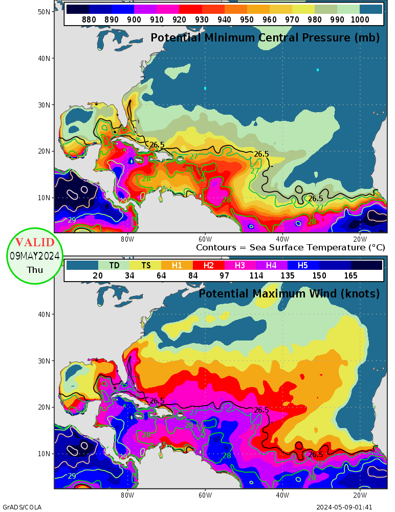

That sounds a bit high, and is higher than what the MPI is for that storm in the 24-72 hr time frame. Of course, storms don't always "behave" by the environmental MPI, but it's quite rare for a storm to meet the MPI, much less exceed it (again, it does happen, but not often by any means). The Eastern GoM is primed and ready to go right now, though...

Image
0 likes   

User avatar
SouthFloridawx
S2K Supporter
S2K Supporter
Posts: 8346
Age: 46
Joined: Tue Jul 26, 2005 1:16 am
Location: Sarasota, FL
Contact:

Re: ATL : Hurricane DANIELLE - Discussion

#1123 Postby SouthFloridawx » Mon Aug 23, 2010 11:47 pm

Definitely not on course with the track this evening... I've seen it before though. You think it's not going on course, but then in the long term... it does in fact do what the NHC and the Models think it's going to do. We'll see if this westward movement is a wobble or if it's a trend. They are much more easily tracked when they have an eye... :D
0 likes   

User avatar
TheDreamTraveler
Category 2
Category 2
Posts: 641
Joined: Sun Aug 22, 2010 3:10 am
Location: PA

Re: ATL : Hurricane DANIELLE - Discussion

#1124 Postby TheDreamTraveler » Mon Aug 23, 2010 11:56 pm

SouthFloridawx wrote:Definitely not on course with the track this evening... I've seen it before though. You think it's not going on course, but then in the long term... it does in fact do what the NHC and the Models think it's going to do. We'll see if this westward movement is a wobble or if it's a trend. They are much more easily tracked when they have an eye... :D


I've been looking at the microwave loops of the eye of Danielle, and it really does continue on a Westward route right now.
0 likes   

User avatar
SouthFloridawx
S2K Supporter
S2K Supporter
Posts: 8346
Age: 46
Joined: Tue Jul 26, 2005 1:16 am
Location: Sarasota, FL
Contact:

Re: ATL : Hurricane DANIELLE - Discussion

#1125 Postby SouthFloridawx » Mon Aug 23, 2010 11:56 pm

ERC so soon?

She really is a nice looking system.
Image
Image
Last edited by SouthFloridawx on Tue Aug 24, 2010 12:01 am, edited 1 time in total.
0 likes   

User avatar
Fego
S2K Supporter
S2K Supporter
Posts: 767
Age: 65
Joined: Sun Apr 18, 2004 7:58 pm
Location: San Juan, Puerto Rico
Contact:

Re: ATL : Hurricane DANIELLE - Discussion

#1126 Postby Fego » Mon Aug 23, 2010 11:58 pm

At 0415 UTC the eye is "gone", I mean, covered... I guess.
0 likes   
Go Giants! Go Niners! Go Warriors!

User avatar
ROCK
Category 5
Category 5
Posts: 9484
Age: 54
Joined: Tue Aug 17, 2004 7:30 am
Location: Kemah, Texas

Re: ATL : Hurricane DANIELLE - Discussion

#1127 Postby ROCK » Mon Aug 23, 2010 11:58 pm

latest steering....3UTC

http://cimss.ssec.wisc.edu/tropic/real- ... 8dlm3.html

looks west for now....should be picking up a little bit of forward speed also I would think.....
0 likes   

User avatar
cycloneye
Admin
Admin
Posts: 145330
Age: 68
Joined: Thu Oct 10, 2002 10:54 am
Location: San Juan, Puerto Rico

Re: ATL : Hurricane DANIELLE - Discussion

#1128 Postby cycloneye » Tue Aug 24, 2010 12:01 am

Fego wrote:At 0415 UTC the eye is "gone", I mean, covered... I guess.


Eye is there at 04:45 UTC.

Image
0 likes   
Visit the Caribbean-Central America Weather Thread where you can find at first post web cams,radars
and observations from Caribbean basin members Click Here

User avatar
cheezyWXguy
Category 5
Category 5
Posts: 6108
Joined: Mon Feb 13, 2006 12:29 am
Location: Dallas, TX

Re: ATL : Hurricane DANIELLE - Discussion

#1129 Postby cheezyWXguy » Tue Aug 24, 2010 12:01 am

SouthFloridawx wrote:ERC so soon?

hahaha what? We havent even seen the whole eye yet. Its still developing, give it time and youll see it soon.
0 likes   

User avatar
Fego
S2K Supporter
S2K Supporter
Posts: 767
Age: 65
Joined: Sun Apr 18, 2004 7:58 pm
Location: San Juan, Puerto Rico
Contact:

Re: ATL : Hurricane DANIELLE - Discussion

#1130 Postby Fego » Tue Aug 24, 2010 12:04 am

I don't see it moving due west, I mean 270... may be 280 .
0 likes   
Go Giants! Go Niners! Go Warriors!

User avatar
SouthFloridawx
S2K Supporter
S2K Supporter
Posts: 8346
Age: 46
Joined: Tue Jul 26, 2005 1:16 am
Location: Sarasota, FL
Contact:

Re: ATL : Hurricane DANIELLE - Discussion

#1131 Postby SouthFloridawx » Tue Aug 24, 2010 12:06 am

The eye is definitely not visible on IR. Though it could be the cloud temps, though they do seem to be warming. I got a feeling we're seeing a ERC.

Image
Last edited by SouthFloridawx on Tue Aug 24, 2010 12:07 am, edited 1 time in total.
0 likes   

User avatar
Fego
S2K Supporter
S2K Supporter
Posts: 767
Age: 65
Joined: Sun Apr 18, 2004 7:58 pm
Location: San Juan, Puerto Rico
Contact:

Re: ATL : Hurricane DANIELLE - Discussion

#1132 Postby Fego » Tue Aug 24, 2010 12:06 am

cycloneye wrote:
Fego wrote:At 0415 UTC the eye is "gone", I mean, covered... I guess.


Eye is there at 04:45 UTC.


Do you think Danielle is already near 16 North?
0 likes   
Go Giants! Go Niners! Go Warriors!

User avatar
cycloneye
Admin
Admin
Posts: 145330
Age: 68
Joined: Thu Oct 10, 2002 10:54 am
Location: San Juan, Puerto Rico

Re: ATL : Hurricane DANIELLE - Discussion

#1133 Postby cycloneye » Tue Aug 24, 2010 12:11 am

Fego wrote:
cycloneye wrote:
Fego wrote:At 0415 UTC the eye is "gone", I mean, covered... I guess.


Eye is there at 04:45 UTC.


Do you think Danielle is already near 16 North?


Has not reached 16N yet.

Image
0 likes   
Visit the Caribbean-Central America Weather Thread where you can find at first post web cams,radars
and observations from Caribbean basin members Click Here

Brent
S2K Supporter
S2K Supporter
Posts: 38090
Age: 36
Joined: Sun May 16, 2004 10:30 pm
Location: Tulsa Oklahoma
Contact:

Re: ATL : Hurricane DANIELLE - Discussion

#1134 Postby Brent » Tue Aug 24, 2010 1:34 am

AL, 06, 2010082406, , BEST, 0, 157N, 440W, 85, 973, HU, 64, NEQ, 25, 15, 10, 25, 1008, 150, 15, 0, 0, L, 0, , 0, 0, DANIELLE, D,

85 kt... 100 mph Cat 2 at 5am.
0 likes   
#neversummer

User avatar
ROCK
Category 5
Category 5
Posts: 9484
Age: 54
Joined: Tue Aug 17, 2004 7:30 am
Location: Kemah, Texas

Re: ATL : Hurricane DANIELLE - Discussion

#1135 Postby ROCK » Tue Aug 24, 2010 2:49 am

even at 973MB your still currently looking wnw steering in place...

http://cimss.ssec.wisc.edu/tropic/real- ... 8dlm3.html

probably miss the next forecast point but well within the cone....just sayin...
0 likes   

User avatar
Crostorm
Category 5
Category 5
Posts: 2060
Age: 50
Joined: Mon Dec 25, 2006 3:51 pm
Location: Croatia-Europe
Contact:

Re: ATL : Hurricane DANIELLE - Discussion

#1136 Postby Crostorm » Tue Aug 24, 2010 3:40 am

Image
0 likes   

WeatherGuesser
Category 5
Category 5
Posts: 2672
Joined: Tue Jun 29, 2010 6:46 am

#1137 Postby WeatherGuesser » Tue Aug 24, 2010 3:51 am

Cat 2 is official
0 likes   

cpdaman
Category 5
Category 5
Posts: 3131
Joined: Sat Jun 10, 2006 11:44 am
Location: SPB county (gulf stream)

Re: ATL : Hurricane DANIELLE - Discussion

#1138 Postby cpdaman » Tue Aug 24, 2010 4:01 am

i think the TUTT/ULL Is starting to exhibit some anti strengthening effects on the system ....i.e dryer air moving closer to the circulation's moisture envelope as well as it looks like it could be slowing which propably means it will be turning more WNW/NW soon?

i think today may feature a slower moving and slowly weakening storm from it's current cat 2 status.

u can see more hostile air invading the west central atlantic and this ULL/TUTT feature really sinking SW

http://www.ssd.noaa.gov/goes/east/catl/flash-wv.html
0 likes   

jconsor
Professional-Met
Professional-Met
Posts: 551
Joined: Mon Jun 30, 2008 9:31 pm
Location: Jerusalem, Israel
Contact:

Re: ATL : Hurricane DANIELLE - Discussion

#1139 Postby jconsor » Tue Aug 24, 2010 4:34 am

I will go on record as forecasting that Danielle will track at least a little SW of 30N 60W. The threat of a direct strike on Bermuda is still low, but the chances of at least tropical storm force winds impacting the island have increased significantly given the current fast westerly motion and ensemble trends. 2 of 20 GFS ensemble members now track Danielle within 50 miles north of Bermuda, and 2 others have her tracking about 150 miles south of Bermuda on a W or NW track.

Keep in mind that Danielle is already a relatively large system, and will grow larger as it interacts with the upper trough to its north and recurves. The ECMWF indicates TS force winds extending out about 150 miles to its west and 225 miles to its east when Danielle is at the latitude of Bermuda (around 32.5N).

I'm not confident Danielle will reach even cat 3 status in the next 24 hours given the dry air intrusion. The best chance for it to intensify significantly (possibly to cat 4) is likely on Wednesday, when divergence increases significantly and the shear vector shifts from westerly to SSW.
0 likes   

User avatar
KWT
Category 5
Category 5
Posts: 31415
Joined: Tue Aug 17, 2004 11:02 am
Location: UK!!!

#1140 Postby KWT » Tue Aug 24, 2010 4:55 am

Yeah this one looks quite ragged right now, may well weaken a touch during the next 6-12hrs again if it doesn't improve the current presentation.

Anyway Bermuda is getting mighty close to the cone right now!
0 likes   
Personal Forecast Disclaimer:
The posts in this forum are NOT official forecast and should not be used as such. They are just the opinion of the poster and may or may not be backed by sound meteorological data. They are NOT endorsed by any professional institution or storm2k.org. For official information, please refer to the NHC and NWS products


Return to “2010”

Who is online

Users browsing this forum: No registered users and 2 guests