ATL: IGOR - Ex Hurricane - Discussion

Moderator: S2k Moderators

Message
Author
ozonepete
Professional-Met
Professional-Met
Posts: 4743
Joined: Mon Sep 07, 2009 3:23 pm
Location: From Ozone Park, NYC / Now in Brooklyn, NY

Re: ATL: IGOR - Hurricane - Discussion

#1621 Postby ozonepete » Wed Sep 15, 2010 9:27 pm

hurricaneCW wrote:Igor circulation and overall size remains much larger than the weakening Julia. While there might be some effects from the interaction, I don't expect Igor to do anything too erratic. I expect Julia to get sheared further and weaken, Igor will probably maintain his intensity and continue to expand. For a classic Fujiwhara effect to take place, the storms have to be nearly identical in their size and strength, otherwise the stronger, larger circulation disrupts the smaller, weaker circulation.


There are many significant interactions with BIG differences in strength:

http://en.wikipedia.org/wiki/Fujiwhara_effect
0 likes   

User avatar
HURAKAN
Professional-Met
Professional-Met
Posts: 46086
Age: 38
Joined: Thu May 20, 2004 4:34 pm
Location: Key West, FL
Contact:

#1622 Postby HURAKAN » Wed Sep 15, 2010 9:30 pm

Image

Igor showing his new eye!
0 likes   

User avatar
x-y-no
Category 5
Category 5
Posts: 8359
Age: 65
Joined: Wed Aug 11, 2004 12:14 pm
Location: Fort Lauderdale, FL

Re:

#1623 Postby x-y-no » Wed Sep 15, 2010 9:32 pm

plasticup wrote:I plan to watch this weather buoy: http://www.ndbc.noaa.gov/station_page.php?station=41044

The closest point of approach should be within 10 miles in about 26 hours. If that is near peak intensity it could provide the hard data that the NHC likes to have befor a Cat 5 classification.


Wave height is already 24 feet.

If the buoy survives, it ought to get some great data.
0 likes   

Dean4Storms
S2K Supporter
S2K Supporter
Posts: 6358
Age: 62
Joined: Sun Aug 31, 2003 1:01 pm
Location: Miramar Bch. FL

#1624 Postby Dean4Storms » Wed Sep 15, 2010 9:36 pm

Looks to be moving west again. Wonder how much the weakening from the EWRC has to do with this step moreso to the west?
0 likes   

ozonepete
Professional-Met
Professional-Met
Posts: 4743
Joined: Mon Sep 07, 2009 3:23 pm
Location: From Ozone Park, NYC / Now in Brooklyn, NY

Re: ATL: IGOR - Hurricane - Discussion

#1625 Postby ozonepete » Wed Sep 15, 2010 9:37 pm

warmer wrote:use this site to estimate the distance of them:
http://jan.ucc.nau.edu/~cvm/latlongdist.html

they seem to have distance of 1400 miles right now


Try it again. I get 1100. Anyway, the important point is they could get close enough toi interact, and it would be fascinating to see.
0 likes   

Migle
Tropical Storm
Tropical Storm
Posts: 203
Age: 43
Joined: Fri Aug 27, 2010 5:30 pm
Location: New Orleans

Re: ATL: IGOR - Hurricane - Discussion

#1626 Postby Migle » Wed Sep 15, 2010 9:42 pm

Igor is a really massive storm now and looks like Bermuda is pretty much going to get a good bit out of this. Nice structure and continues expanding.
0 likes   

User avatar
HURAKAN
Professional-Met
Professional-Met
Posts: 46086
Age: 38
Joined: Thu May 20, 2004 4:34 pm
Location: Key West, FL
Contact:

Re: ATL: IGOR - Hurricane - Discussion

#1627 Postby HURAKAN » Wed Sep 15, 2010 10:01 pm

ozonepete wrote:
warmer wrote:use this site to estimate the distance of them:
http://jan.ucc.nau.edu/~cvm/latlongdist.html

they seem to have distance of 1400 miles right now


Try it again. I get 1100. Anyway, the important point is they could get close enough toi interact, and it would be fascinating to see.


Both are now located at 20.2ºN, so 56.5ºW - 34.6ºW is 21.9 * 60 = 1314 nm * 1.152 = 1514 miles
0 likes   

User avatar
Ptarmigan
Category 5
Category 5
Posts: 5313
Joined: Wed Aug 16, 2006 9:06 pm

Re: ATL: IGOR - Hurricane - Discussion

#1628 Postby Ptarmigan » Wed Sep 15, 2010 10:16 pm

I notice Igor's hurricane force winds extent has not changed that much, while tropical storm force winds have expanded a great deal.

HURRICANE FORCE WINDS EXTEND OUTWARD UP TO 45 MILES...75 KM...FROM
THE CENTER...AND TROPICAL STORM FORCE WINDS EXTEND OUTWARD UP TO 240
MILES...390 KM.
0 likes   

ozonepete
Professional-Met
Professional-Met
Posts: 4743
Joined: Mon Sep 07, 2009 3:23 pm
Location: From Ozone Park, NYC / Now in Brooklyn, NY

Re: ATL: IGOR - Hurricane - Discussion

#1629 Postby ozonepete » Wed Sep 15, 2010 10:27 pm

HURAKAN wrote:
ozonepete wrote:
warmer wrote:use this site to estimate the distance of them:
http://jan.ucc.nau.edu/~cvm/latlongdist.html

they seem to have distance of 1400 miles right now


Try it again. I get 1100. Anyway, the important point is they could get close enough toi interact, and it would be fascinating to see.


Both are now located at 20.2ºN, so 56.5ºW - 34.6ºW is 21.9 * 60 = 1314 nm * 1.152 = 1514 miles


Thanks, Hurakan! I'm still thinking that they will get close enough for interaction if they continue at their present speeds.
0 likes   

Battlebrick
Tropical Storm
Tropical Storm
Posts: 177
Joined: Thu Sep 02, 2010 9:55 pm

Re: ATL: IGOR - Hurricane - Discussion

#1630 Postby Battlebrick » Wed Sep 15, 2010 10:33 pm

0 likes   
Lim_Fao on IRC.

The following post is NOT an official forecast and should not be used as such. It is just the opinion of the poster and may or may not be backed by sound meteorological data. It is NOT endorsed by any professional institution including storm2k.org. For Official Information please refer to the NHC and NWS products.

emeraldislencguy
S2K Supporter
S2K Supporter
Posts: 207
Joined: Sun Aug 27, 2006 4:35 pm
Location: emerald isle nc
Contact:

Re: ATL: IGOR - Hurricane - Discussion

#1631 Postby emeraldislencguy » Wed Sep 15, 2010 10:43 pm

they have just posted rip current and heavy surf warnings for the coast of nc
how high fo yall think the waves will get
also our local tv met sais the cape verde season is over due to the upwelling from all the hurricanes says they ahve caused the water to cool off
what do the pro mets think of this
0 likes   

emeraldislencguy
S2K Supporter
S2K Supporter
Posts: 207
Joined: Sun Aug 27, 2006 4:35 pm
Location: emerald isle nc
Contact:

Re: ATL: IGOR - Hurricane - Discussion

#1632 Postby emeraldislencguy » Wed Sep 15, 2010 10:48 pm

please excuse my bad spelling I should have turned the lights on
0 likes   

RL3AO
Moderator-Pro Met
Moderator-Pro Met
Posts: 16308
Joined: Thu Jun 14, 2007 10:03 pm
Location: NC

Re: ATL: IGOR - Hurricane - Discussion

#1633 Postby RL3AO » Wed Sep 15, 2010 11:13 pm

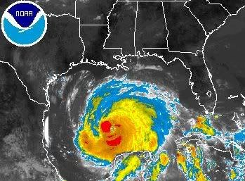
NOTICE: PHOTOSHOPPED IMAGE

I don't want to startle anyone. :P

To help with showing how big Igor is, here's what it would look like in the Gulf of Mexico.

Image
0 likes   

User avatar
South Texas Storms
Professional-Met
Professional-Met
Posts: 4226
Joined: Thu Jun 24, 2010 12:28 am
Location: Houston, TX

Re: ATL: IGOR - Hurricane - Discussion

#1634 Postby South Texas Storms » Wed Sep 15, 2010 11:14 pm

:uarrow:
wow what a big bad boy. :D
0 likes   

Shuriken

Re: ATL: IGOR - Hurricane - Discussion

#1635 Postby Shuriken » Thu Sep 16, 2010 1:11 am

Battlebrick wrote:http://www.ssd.noaa.gov/goes/flt/t1/flash-vis.html

Huge eye about to form.

WOW.
It'll should go annular at that point.
0 likes   

Aric Dunn
Category 5
Category 5
Posts: 21238
Age: 42
Joined: Sun Sep 19, 2004 9:58 pm
Location: Ready for the Chase.
Contact:

Re: ATL: IGOR - Hurricane - Discussion

#1636 Postby Aric Dunn » Thu Sep 16, 2010 1:39 am

Shuriken wrote:
Battlebrick wrote:http://www.ssd.noaa.gov/goes/flt/t1/flash-vis.html

Huge eye about to form.

WOW.
It'll should go annular at that point.


yes its going to be very large..

Image
0 likes   
Note: If I make a post that is brief. Please refer back to previous posts for the analysis or reasoning. I do not re-write/qoute what my initial post said each time.
If there is nothing before... then just ask :)

Space & Atmospheric Physicist, Embry-Riddle Aeronautical University,
I believe the sky is falling...

User avatar
wxmann_91
Category 5
Category 5
Posts: 8013
Age: 34
Joined: Fri Jul 15, 2005 2:49 pm
Location: Southern California
Contact:

Re: ATL: IGOR - Hurricane - Discussion

#1637 Postby wxmann_91 » Thu Sep 16, 2010 2:00 am

Shuriken wrote:
Battlebrick wrote:http://www.ssd.noaa.gov/goes/flt/t1/flash-vis.html

Huge eye about to form.

WOW.
It'll should go annular at that point.

Shear and the warm SST's over Igor should preclude that.

But it will get pretty big. Somewhat concerned about wave/surge potential in Bermuda, even though this will likely be down a couple categories by the time it gets there.
0 likes   

User avatar
abajan
S2K Supporter
S2K Supporter
Posts: 4230
Joined: Sun Sep 07, 2003 5:10 am
Location: Barbados

Re: ATL: IGOR - Hurricane - Discussion

#1638 Postby abajan » Thu Sep 16, 2010 3:44 am

HURAKAN wrote:
ozonepete wrote:
warmer wrote:use this site to estimate the distance of them:
http://jan.ucc.nau.edu/~cvm/latlongdist.html

they seem to have distance of 1400 miles right now


Try it again. I get 1100. Anyway, the important point is they could get close enough toi interact, and it would be fascinating to see.


Both are now located at 20.2ºN, so 56.5ºW - 34.6ºW is 21.9 * 60 = 1314 nm * 1.152 = 1514 miles
The results given by the calculator at http://jan.ucc.nau.edu/~cvm/latlongdist.html for the 11 p.m. coordinates are 1234.4790 nautical miles and 1420.5882 statute miles.
0 likes   

Shuriken

Re: ATL: IGOR - Hurricane - Discussion

#1639 Postby Shuriken » Thu Sep 16, 2010 3:57 am

wxmann_91 wrote:
Shuriken wrote:
Battlebrick wrote:http://www.ssd.noaa.gov/goes/flt/t1/flash-vis.html

Huge eye about to form.

WOW.
It'll should go annular at that point.
Shear and the warm SST's over Igor should preclude that.
The formerly-present feeder-bands and arcs are already dying as the new, huge eye firms up, and radial outflow aloft is now smothering everything in sight. I.e., annular. The storm is at the same longitude (55W) as Isabel when she evolved into a giant donutcane cat-5.

Unofficially, today will officially be "freak-out" day when the sats are splashed across the morning news.
0 likes   

User avatar
abajan
S2K Supporter
S2K Supporter
Posts: 4230
Joined: Sun Sep 07, 2003 5:10 am
Location: Barbados

#1640 Postby abajan » Thu Sep 16, 2010 4:40 am

IMHO there’s no hint of annularity. As a matter of fact, a vigorous feeder band seems to be developing on the southwestern side of Igor and the Leeward Islands may well experience squally weather at some point.

The preceding post is NOT an official forecast and should not be used as such. It is just the opinion of the poster and may or may not be backed by sound meteorological data. It is NOT endorsed by any professional institution including storm2k.org. For Official Information please refer to the NHC and NWS products.
0 likes   


Return to “2010”

Who is online

Users browsing this forum: No registered users and 5 guests