Pouch PGI50L in NW Carribean - Code Orange - (Is Invest 96L)

This is the general tropical discussion area. Anyone can take their shot at predicting a storms path.

Moderator: S2k Moderators

Forum rules

The posts in this forum are NOT official forecasts and should not be used as such. They are just the opinion of the poster and may or may not be backed by sound meteorological data. They are NOT endorsed by any professional institution or STORM2K. For official information, please refer to products from the National Hurricane Center and National Weather Service.

Help Support Storm2K
Message
Author
User avatar
Blown Away
S2K Supporter
S2K Supporter
Posts: 10145
Joined: Wed May 26, 2004 6:17 am

Re: Pouch PGI50L in NW Carribean - Code Orange

#1261 Postby Blown Away » Mon Sep 27, 2010 6:38 am

Image

TAFB now showing "Possible Tropical Cyclone" in 72 hours as the low landfalls in SFL.
0 likes   
Hurricane Eye Experience: David 79, Irene 99, Frances 04, Jeanne 04, Wilma 05... EYE COMING MY WAY IN 2024…
Hurricane Brush Experience: Andrew 92, Erin 95, Floyd 99, Matthew 16, Irma 17, Ian 22, Nicole 22…

User avatar
cycloneye
Admin
Admin
Posts: 145308
Age: 68
Joined: Thu Oct 10, 2002 10:54 am
Location: San Juan, Puerto Rico

Re: Pouch PGI50L in NW Carribean - Code Orange

#1262 Postby cycloneye » Mon Sep 27, 2010 6:39 am

Remains at 30%

TROPICAL WEATHER OUTLOOK
NWS TPC/NATIONAL HURRICANE CENTER MIAMI FL
800 AM EDT MON SEP 27 2010

FOR THE NORTH ATLANTIC...CARIBBEAN SEA AND THE GULF OF MEXICO...

DISORGANIZED CLOUDINESS AND THUNDERSTORMS OVER THE NORTHWESTERN
CARIBBEAN SEA ARE ASSOCIATED WITH A BROAD AREA OF LOW PRESSURE.
ENVIRONMENTAL CONDITIONS APPEAR FAVORABLE FOR GRADUAL DEVELOPMENT OF
THIS SYSTEM DURING THE NEXT COUPLE OF DAYS AS IT DRIFTS NORTHWARD.
THERE IS A MEDIUM CHANCE...30 PERCENT...OF THIS SYSTEM BECOMING A
TROPICAL CYCLONE DURING THE NEXT 48 HOURS.


A SMALL...SLOW-MOVING...LOW PRESSURE SYSTEM LOCATED ABOUT 725 MILES
WEST-SOUTHWEST OF THE CAPE VERDE ISLANDS IS PRODUCING DISORGANIZED
SHOWERS AND THUNDERSTORMS. DEVELOPMENT...IF ANY...OF THIS SYSTEM
IS EXPECTED TO BE SLOW TO OCCUR. THERE IS A LOW CHANCE...10
PERCENT...OF THIS SYSTEM BECOMING A TROPICAL CYCLONE DURING THE
NEXT 48 HOURS.

ELSEWHERE...TROPICAL CYCLONE FORMATION IS NOT EXPECTED DURING THE
NEXT 48 HOURS.

$$
FORECASTER PASCH
Image
0 likes   
Visit the Caribbean-Central America Weather Thread where you can find at first post web cams,radars
and observations from Caribbean basin members Click Here

User avatar
ObsessedMiami
Category 1
Category 1
Posts: 431
Joined: Tue Aug 31, 2004 8:08 pm
Location: West Kendall, Fl

Re: Pouch PGI50L in NW Carribean - Code Orange

#1263 Postby ObsessedMiami » Mon Sep 27, 2010 6:55 am

This blob is quite the tease and the NHC is the chaparone. She keeps flashing her legs and the NHC says, she is not that kind of girl, no matter what her reputation says.
0 likes   

User avatar
Vortex
S2K Supporter
S2K Supporter
Posts: 4644
Age: 53
Joined: Fri Aug 01, 2003 9:34 pm
Location: Hilton Head, SC

#1264 Postby Vortex » Mon Sep 27, 2010 6:58 am

Caymans are gusty out of the SSW with falling pressures...As the day goes on I expect to see an organized center begin to take shape to the WNW of the caymans...I expect it to go to Nicole quickly with such low pressures and deep convection beginning to fire....


Owen Roberts, GC (Airport)
Updated: 54 min 43 sec ago
82 °F
Scattered Clouds
Humidity: 79%
Dew Point: 75 °F
Wind: 16 mph from the SSW
Pressure: 29.74 in (Falling)
0 likes   

Aric Dunn
Category 5
Category 5
Posts: 21238
Age: 42
Joined: Sun Sep 19, 2004 9:58 pm
Location: Ready for the Chase.
Contact:

#1265 Postby Aric Dunn » Mon Sep 27, 2010 6:59 am

nothing exciting to relay yet .... just the remnants of matthew seem to be creeping into the southern BOC...
0 likes   
Note: If I make a post that is brief. Please refer back to previous posts for the analysis or reasoning. I do not re-write/qoute what my initial post said each time.
If there is nothing before... then just ask :)

Space & Atmospheric Physicist, Embry-Riddle Aeronautical University,
I believe the sky is falling...

User avatar
GCANE
S2K Supporter
S2K Supporter
Posts: 11496
Joined: Mon Oct 22, 2007 8:03 am

Re: Pouch PGI50L in NW Carribean - Code Orange

#1266 Postby GCANE » Mon Sep 27, 2010 7:02 am

The convergence center as shown on MIMIC-TPW has shifted back east to more over the Bay of Honduras.

http://cimss.ssec.wisc.edu/tropic/real- ... t72hrs.gif

Circulation looks broad and relatively slow rotation which IMHO indicates a slower spin up.

However, convection is very deep and outflow channels seem to be improving by the hour.

200mb vorticity is very low over the convection.


Image


Image
0 likes   

HURRICANELONNY
Category 5
Category 5
Posts: 1383
Joined: Wed May 07, 2003 6:48 am
Location: HOLLYWOOD.FL

#1267 Postby HURRICANELONNY » Mon Sep 27, 2010 7:18 am

0 likes   
hurricanelonny

Aric Dunn
Category 5
Category 5
Posts: 21238
Age: 42
Joined: Sun Sep 19, 2004 9:58 pm
Location: Ready for the Chase.
Contact:

#1268 Postby Aric Dunn » Mon Sep 27, 2010 7:41 am

ok well after looking the most recent visible images and some observations from the area. There appears to small weak LLC possibly forming east of Cozumel. It also shows up on radar out of Cuba.
0 likes   
Note: If I make a post that is brief. Please refer back to previous posts for the analysis or reasoning. I do not re-write/qoute what my initial post said each time.
If there is nothing before... then just ask :)

Space & Atmospheric Physicist, Embry-Riddle Aeronautical University,
I believe the sky is falling...

User avatar
Trader Ron
S2K Supporter
S2K Supporter
Posts: 928
Joined: Tue Jul 22, 2003 7:25 pm
Location: Naples,Fl
Contact:

#1269 Postby Trader Ron » Mon Sep 27, 2010 7:50 am

If NOAA Radio is to believed, it doesn't sound like much of a storm coming our way.
Just a rainy event with winds 15-20 kts. :D
0 likes   

User avatar
srainhoutx
S2K Supporter
S2K Supporter
Posts: 6919
Age: 67
Joined: Sun Jan 14, 2007 11:34 am
Location: Haywood County, NC
Contact:

Re: Pouch PGI50L in NW Carribean - Code Orange

#1270 Postby srainhoutx » Mon Sep 27, 2010 7:52 am

Upper Low is a bit further S (S of Memphis) than progged. It appears that the GFS may well have been unto something after all....

Image
0 likes   
Carla/Alicia/Jerry(In The Eye)/Michelle/Charley/Ivan/Dennis/Katrina/Rita/Wilma/Ike/Harvey

Member: National Weather Association
Wx Infinity Forums
http://wxinfinity.com/index.php

Facebook.com/WeatherInfinity
Twitter @WeatherInfinity

otowntiger
Category 5
Category 5
Posts: 1921
Joined: Tue Aug 31, 2004 7:06 pm

Re: Pouch PGI50L in NW Carribean - Code Yellow

#1271 Postby otowntiger » Mon Sep 27, 2010 7:54 am

jinftl wrote:Or it could be related to the fact the NHC still is giving this a 10% shot of developing in the next 48 hours...don't get me wrong...if this is about to blow up, the media will be all over it....it's just that the s2k buzz has eclipsed the actual reality of development so far.


You just hit the nail on the head!!!!
Last edited by otowntiger on Mon Sep 27, 2010 7:55 am, edited 1 time in total.
0 likes   

ericinmia
S2K Supporter
S2K Supporter
Posts: 1573
Joined: Fri Sep 12, 2003 11:15 pm
Location: Miami Lakes, FL

Re: Pouch PGI50L in NW Carribean - Code Orange

#1272 Postby ericinmia » Mon Sep 27, 2010 7:54 am

You can see a big difference in the region on the Visible in this loop, (shows yesterday, last night, then today...)

Loop: http://www.meteo.psu.edu/ewall/SATATL_F ... 16vis.html

Image
Image

Incase anyone didn't have the link, the PSU E-wall is a pretty good sight for a bunch of random things. Hard to get used to though at first....
(I like it because I don't have to remember the link, just type "psu ewall" into google. ) :)

E-wall: http://www.meteo.psu.edu/~gadomski/ewall.html
Tropical E-wall: http://www.meteo.psu.edu/ewall/ewalltropatl.html

-Eric
0 likes   

User avatar
Vortex
S2K Supporter
S2K Supporter
Posts: 4644
Age: 53
Joined: Fri Aug 01, 2003 9:34 pm
Location: Hilton Head, SC

Re: Pouch PGI50L in NW Carribean - Code Orange

#1273 Postby Vortex » Mon Sep 27, 2010 7:55 am

Watch 18.3/83.5..the 2 convective complexes should gel here and spark genesis later today...
0 likes   

User avatar
TheBurn
Category 2
Category 2
Posts: 540
Joined: Thu Jul 28, 2005 4:00 pm
Location: Rincon, PR

Re: Pouch PGI50L in NW Carribean - Code Orange

#1274 Postby TheBurn » Mon Sep 27, 2010 7:56 am

Image
Image
0 likes   

User avatar
Vortex
S2K Supporter
S2K Supporter
Posts: 4644
Age: 53
Joined: Fri Aug 01, 2003 9:34 pm
Location: Hilton Head, SC

#1275 Postby Vortex » Mon Sep 27, 2010 8:11 am

1245Z Vis...Low beginning to organize w of the caymans..Hi-res visible clearly indicates a stronger surface reflection beginning to take shape between the 2 complexes on the western side of the complex closer to the caymans..Expect the 2 areas to merge with a developing LLC right in between....
0 likes   

Aric Dunn
Category 5
Category 5
Posts: 21238
Age: 42
Joined: Sun Sep 19, 2004 9:58 pm
Location: Ready for the Chase.
Contact:

Re:

#1276 Postby Aric Dunn » Mon Sep 27, 2010 8:16 am

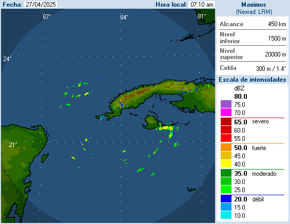
Vortex wrote:1245Z Vis...Low beginning to organize w of the caymans..Hi-res visible clearly indicates a stronger surface reflection beginning to take shape between the 2 complexes on the western side of the complex closer to the caymans..Expect the 2 areas to merge with a developing LLC right in between....


its very weak right now actually and I still cant find a Northerly winds anywhere near by yet. but the greatest low level turn i can see is very near Cozumel.. on the NW side of the convection near Cozumel.
0 likes   
Note: If I make a post that is brief. Please refer back to previous posts for the analysis or reasoning. I do not re-write/qoute what my initial post said each time.
If there is nothing before... then just ask :)

Space & Atmospheric Physicist, Embry-Riddle Aeronautical University,
I believe the sky is falling...

User avatar
Blown Away
S2K Supporter
S2K Supporter
Posts: 10145
Joined: Wed May 26, 2004 6:17 am

Re: Pouch PGI50L in NW Carribean - Code Orange

#1277 Postby Blown Away » Mon Sep 27, 2010 8:19 am

Deep persistent convection, broad cyclonic spinning, Code Orange, and TAFB indicating "Possible Tropical Cyclone" in 72 hours. Question, why is this area not an "Invest"???
0 likes   
Hurricane Eye Experience: David 79, Irene 99, Frances 04, Jeanne 04, Wilma 05... EYE COMING MY WAY IN 2024…
Hurricane Brush Experience: Andrew 92, Erin 95, Floyd 99, Matthew 16, Irma 17, Ian 22, Nicole 22…

User avatar
gatorcane
S2K Supporter
S2K Supporter
Posts: 23691
Age: 47
Joined: Sun Mar 13, 2005 3:54 pm
Location: Boca Raton, FL

Re: Pouch PGI50L in NW Carribean - Code Orange

#1278 Postby gatorcane » Mon Sep 27, 2010 8:20 am

Blown Away wrote:Deep persistent convection, broad cyclonic spinning, Code Orange, and TAFB indicating "Possible Tropical Cyclone" in 72 hours. Question, why is this area not an "Invest"???


I agree, I have no idea why it is not an invest.
0 likes   

User avatar
Evil Jeremy
S2K Supporter
S2K Supporter
Posts: 5463
Age: 32
Joined: Mon Apr 10, 2006 2:10 pm
Location: Los Angeles, CA

Re: Pouch PGI50L in NW Carribean - Code Orange

#1279 Postby Evil Jeremy » Mon Sep 27, 2010 8:22 am

I logged on this morning and headed directly to SFWMD for computer models. How stupid of me. Well, not me actually. Why is this not an invest yet? There have been worst looking, less threatening systems that have been invested this year.
0 likes   
Frances 04 / Jeanne 04 / Katrina 05 / Wilma 05 / Fay 08 / Debby 12 / Andrea 13 / Colin 16 / Hermine 16 / Matthew 16 / Irma 17

User avatar
cycloneye
Admin
Admin
Posts: 145308
Age: 68
Joined: Thu Oct 10, 2002 10:54 am
Location: San Juan, Puerto Rico

Re: Pouch PGI50L in NW Carribean - Code Orange

#1280 Postby cycloneye » Mon Sep 27, 2010 8:25 am

Radar from Pinar del Rio in Western Cuba. Some turning is seen.

Image
0 likes   
Visit the Caribbean-Central America Weather Thread where you can find at first post web cams,radars
and observations from Caribbean basin members Click Here


Return to “Talkin' Tropics”

Who is online

Users browsing this forum: Google Adsense [Bot], ouragans, USTropics, wwizard, wxman57 and 55 guests