Yet another storm to form in the NW Caribbean
Moderator: S2k Moderators
Forum rules

The posts in this forum are NOT official forecasts and should not be used as such. They are just the opinion of the poster and may or may not be backed by sound meteorological data. They are NOT endorsed by any professional institution or STORM2K. For official information, please refer to products from the National Hurricane Center and National Weather Service.
-
dwsqos2
Re: Yet another storm to form in the NW Caribbean
There wasn't much on the 0Z gfs through hour 144. This season is borderline hysterical. The two periods, a portion of July and now, during which the basin experienced the best tropical forcing may go down in hurricane history as producing nothing horribly significant. However, during a pretty significant subsidence wave, we ended up with a major hurricane (Karl). Heh.
0 likes

Re: Yet another storm to form in the NW Caribbean
I am wondering as TD16 weakens over Cuba & S FL that the MIMIC-TPW convergence may get redirected back south to under the deep convection.
http://cimss.ssec.wisc.edu/tropic/real- ... t72hrs.gif
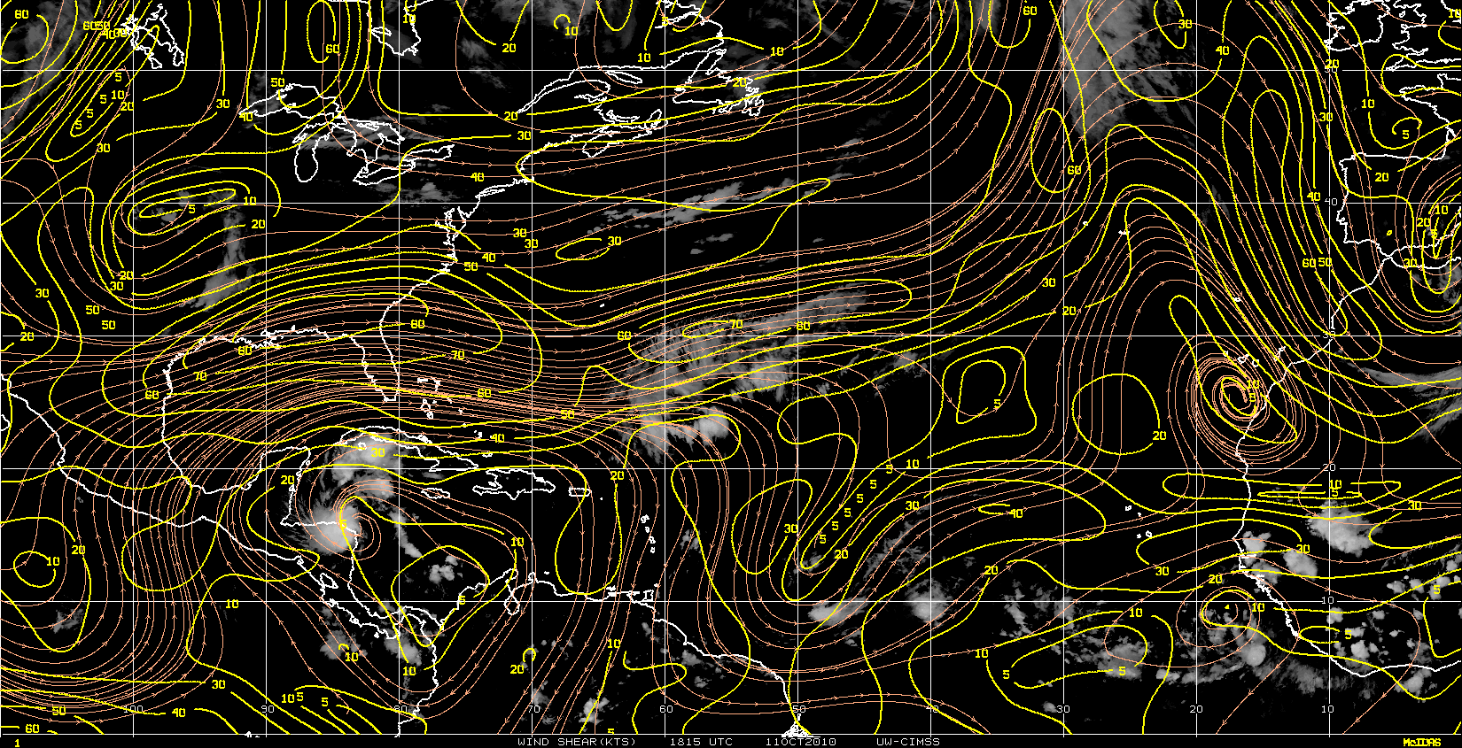
Nice anti-cyclone down there, plenty of overshooting tops, and a big area of deep convection topping out 55 to 60K-ft.

http://cimss.ssec.wisc.edu/tropic/real- ... t72hrs.gif
Nice anti-cyclone down there, plenty of overshooting tops, and a big area of deep convection topping out 55 to 60K-ft.
0 likes


-
otowntiger
- Category 5

- Posts: 1932
- Joined: Tue Aug 31, 2004 7:06 pm
Re: Yet another storm to form in the NW Caribbean
Are the models just showing a basic repeat of #16 as far as track and intensity? Earlier I know they were showing some pretty significant development and at least one strong storm during the last week or two that would slam the Florida penninsula, but have they all backed off of the apocalyptic prognostications?
0 likes

-
ConvergenceZone
.gif)
- Category 5
- Posts: 5241
- Joined: Fri Jul 29, 2005 1:40 am
- Location: Northern California
Re: Yet another storm to form in the NW Caribbean
otowntiger wrote:Are the models just showing a basic repeat of #16 as far as track and intensity? Earlier I know they were showing some pretty significant development and at least one strong storm during the last week or two that would slam the Florida penninsula, but have they all backed off of the apocalyptic prognostications?
I know what you mean otowntiger *Yawn*
While I'm happy that the US isn't having to deal with any majors so far this yer, the systems that do get going near the U.S. have been some of the most boring to track in recent memory...I enjoyed tracking Ivan, that was fun... But a string of waves that originally look like they are going to develop and then struggle to even make it to depression status are getting tiresome to say the least...
0 likes
-
otowntiger
- Category 5
- Posts: 1932
- Joined: Tue Aug 31, 2004 7:06 pm
Re: Yet another storm to form in the NW Caribbean
yep, 'yawn' is right. I guess I'm as guilty as anybody buying into all the hype on this site about long range model after model depicting something dangerous and imenent (within 2 weeks or so) significantly affecting our weather. The long range models are truly just for pure entertainment like they say. It was just the extreme consistancy of some of them that piqued my interest. They were onto something as far as tropical development but in what form they were sorely mistaken, that is up until about 3-4 days out. Of course we all know and its well documented that we don't have the technology to predict intensity yet.ConvergenceZone wrote:otowntiger wrote:Are the models just showing a basic repeat of #16 as far as track and intensity? Earlier I know they were showing some pretty significant development and at least one strong storm during the last week or two that would slam the Florida penninsula, but have they all backed off of the apocalyptic prognostications?
I know what you mean otowntiger *Yawn*
While I'm happy that the US isn't having to deal with any majors so far this yer, the systems that do get going near the U.S. have been some of the most boring to track in recent memory...I enjoyed tracking Ivan, that was fun... But a string of waves that originally look like they are going to develop and then struggle to even make it to depression status are getting tiresome to say the least...
0 likes
-
otowntiger
- Category 5
- Posts: 1932
- Joined: Tue Aug 31, 2004 7:06 pm
Re:
HURAKAN wrote:Computer models should not be used to forecast intensity. Learn that.
Last edited by otowntiger on Wed Sep 29, 2010 10:07 am, edited 1 time in total.
0 likes

Re: Yet another storm to form in the NW Caribbean
I know the global models are not good for intensity but what about HWRF, GFDL and SHIPS?
0 likes
-
HURAKAN

- Professional-Met

- Posts: 46084
- Age: 39
- Joined: Thu May 20, 2004 4:34 pm
- Location: Key West, FL
- Contact:
Re: Re:
otowntiger wrote:HURAKAN wrote:Computer models should not be used to forecast intensity. Learn that.Thanks. I've known that for a long time. Read the last line of my post: "Of course we all know and its well documented that we don't have the technology to predict intensity yet."
I don't like when people in this board say that we hype anything. Maybe the amateurs try to hype stuff once in a while but it's unusual for the seasoned members and especially, the pro-Mets, to hype anything. If you go to an open forum, the last thing you should take very serious are opinions from amateurs.
Also, even when there's a consensus, nothing is set in stone.
0 likes
-
SouthFloridawx

- S2K Supporter

- Posts: 8346
- Age: 47
- Joined: Tue Jul 26, 2005 1:16 am
- Location: Sarasota, FL
- Contact:
Re: Yet another storm to form in the NW Caribbean
Sweet... there is a thread for the convection south of Nicole.
0 likes
-
ConvergenceZone
- Category 5
- Posts: 5241
- Joined: Fri Jul 29, 2005 1:40 am
- Location: Northern California
Re: Re:
HURAKAN wrote:otowntiger wrote:HURAKAN wrote:Computer models should not be used to forecast intensity. Learn that.
I don't like when people in this board say that we hype anything. Maybe the amateurs try to hype stuff once in a while but it's unusual for the seasoned members and especially, the pro-Mets, to hype anything. If you go to an open forum, the last thing you should take very serious are opinions from amateurs.
Also, even when there's a consensus, nothing is set in stone.
HURAKAN, it's not posters that are over-hyping it, it's the models that are over-hyping it...
0 likes
-
HURAKAN
- Professional-Met
- Posts: 46084
- Age: 39
- Joined: Thu May 20, 2004 4:34 pm
- Location: Key West, FL
- Contact:
Re: Re:
ConvergenceZone wrote:HURAKAN, it's not posters that are over-hyping it, it's the models that are over-hyping it...
But that's normal. I usually (99.9%) don't take the intensity forecast too much into consideration.
0 likes


Re: Yet another storm to form in the NW Caribbean
Macrocane wrote:I know the global models are not good for intensity but what about HWRF, GFDL and SHIPS?
Hoping to improve

0 likes


Re: Yet another storm to form in the NW Caribbean
This year despite having been quite active has been exceptionally fortunate with few disasters, all of which affected Central America rather slightly. So far so good, and as far as the season to date with big impacts to the States, I think this smiley sums it up: " "
Will we see a " "
" 
That is the question. Maybe October 8th-November 25th once we get the Carib Patrol going. Otherwise we WILL have totally lucked out!
Will we see a "
That is the question. Maybe October 8th-November 25th once we get the Carib Patrol going. Otherwise we WILL have totally lucked out!
0 likes
Georges '98, Irene '99, Frances '04, Jeanne '04, Katrina '05, Wilma '05, Gustav '08, Isaac '12, Matthew '16, Florence '18, Michael '18, Ian '22

Re: Re:
ConvergenceZone wrote:otowntiger wrote:HURAKAN wrote:
I don't like when people in this board say that we hype anything. Maybe the amateurs try to hype stuff once in a while but it's unusual for the seasoned members and especially, the pro-Mets, to hype anything. If you go to an open forum, the last thing you should take very serious are opinions from amateurs.
Also, even when there's a consensus, nothing is set in stone.
HURAKAN, it's not posters that are over-hyping it, it's the models that are over-hyping it...
Huh.
How does one program a model to "overhype"???
0 likes
Who is online
Users browsing this forum: Yellow Evan and 129 guests