Winter 2010-11 for the Southern Plains
Moderator: S2k Moderators
Forum rules
 The posts in this forum are NOT official forecast and should not be used as such. They are just the opinion of the poster and may or may not be backed by sound meteorological data. They are NOT endorsed by any professional institution or STORM2K.

The posts in this forum are NOT official forecast and should not be used as such. They are just the opinion of the poster and may or may not be backed by sound meteorological data. They are NOT endorsed by any professional institution or STORM2K.

Re: Winter 2010-11 for the Southern Plains
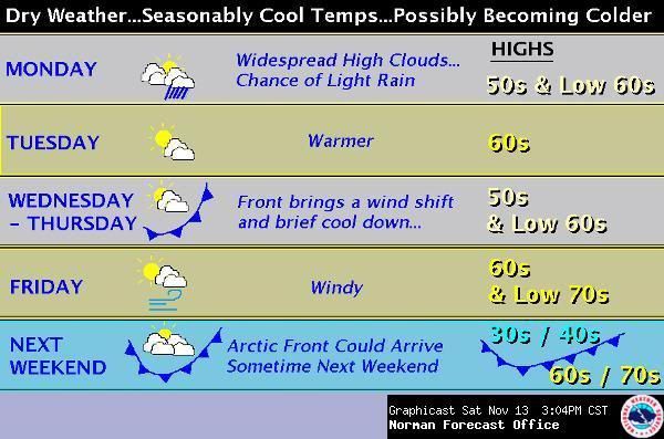
Certainly looks like the end of the month will be chilly.
0 likes
-
Extremeweatherguy

- Category 5

- Posts: 11095
- Joined: Mon Oct 10, 2005 8:13 pm
- Location: Florida
From the Norman, OK NWS afternoon discussion:
...THE LATTER PART OF NEXT WEEK BEARS
WATCHING...THOUGH. MODELS INDICATE A VERY COLD AIR MASS BUILDING IN
THE FAVORABLE FETCH REGION OF ALASKA AND WESTERN CANADA. THERE IS NO
INDICATION THAT THE COLD AIR WILL BREAK LOOSE IN A RAPID
FASHION...BUT INCREASINGLY COOLER AIR MAY SLIP INTO THE SOUTHERN
PLAINS BEHIND THE INITIAL FRONT ON WEDNESDAY.
0 likes

Looks like the trend as of late is bulk of the cold air pushing east through Canada vs due south. I guess it would make sense since many of the systems shown are GL cutters swinging from the rockies and not any that would open the gates far enough south. That SE ridge perhaps is starting to make it's footing.
Boy when they show that sharp contrast of cold north vs warm south in La Nina really does work that way...a lot of cold air bottled up there.
Boy when they show that sharp contrast of cold north vs warm south in La Nina really does work that way...a lot of cold air bottled up there.
0 likes
The above post and any post by Ntxw is NOT an official forecast and should not be used as such. It is just the opinion of the poster and may or may not be backed by sound meteorological data. It is NOT endorsed by any professional institution including Storm2k. For official information, please refer to NWS products.
Help support Storm2K!
-
HockeyTx82
- S2K Supporter

- Posts: 2787
- Joined: Tue Oct 27, 2009 11:17 am
- Location: Ponder, TX
Re: Winter 2010-11 for the Southern Plains
Now just bring it south and east and I would be a happy person right now.........
http://its.txdot.gov/ITS_WEB/FrontEnd/d ... llo&t=cctv

http://its.txdot.gov/ITS_WEB/FrontEnd/d ... llo&t=cctv
0 likes
Don't hold me accountable for anything I post on this forum. Leave the real forecasting up to the professionals.
Location: Ponder, TX (all observation posts are this location unless otherwise noted)
Location: Ponder, TX (all observation posts are this location unless otherwise noted)
-
srainhoutx

- S2K Supporter
- Posts: 6919
- Age: 68
- Joined: Sun Jan 14, 2007 11:34 am
- Location: Haywood County, NC
- Contact:
Re: Winter 2010-11 for the Southern Plains
HPC:...don't give up on the Arctic Front just yet, folks... 
PRELIMINARY EXTENDED FORECAST DISCUSSION
NWS HYDROMETEOROLOGICAL PREDICTION CENTER CAMP SPRINGS MD
900 AM EST FRI NOV 12 2010
VALID 12Z TUE NOV 16 2010 - 12Z FRI NOV 19 2010
MODELS AND ENSEMBLES GENERALLY DEPICT THE LONGWAVE PATTERN
STARTING OFF DAY 3 WITH RIDGES OFF EACH COAST OF NOAM AND A TROF
OVER THE CENTRAL CONUS. HOWEVER AN IMPORTANT TRANSITION BEGINS TUE
AS A STRONG RIDGE OR CLOSED HIGH DEVELOPS OVER THE BERING SEA.
DOWNSTREAM HEIGHT FALLS OVER THE ERN GULF OF ALASKA BEGIN TO
SQUASH AN ERSTWHILE STRONG ERN PACIFIC RIDGE...TURNING FLOW TO
MORE WNW INTO THE PACIFIC NW AND VANCOUVER/BRITISH COLUMBIA. THE
WESTERLY COMPONENT OF THE FLOW HAS A STRONG BEARING ON HOW MUCH
COLD AIR IN CANADA WILL BE ABLE TO BLEED S E OF THE ROCKIES IN THE
DAY 5-6 TIME FRAME. USING THE ECMWF ENSEMBLE MEAN AS OUR MAIN
GUIDANCE...WE ALLOWED MODERATE COOLING TO COME S INTO THE N
CENTRAL STATES BEHIND A DEEPENING LOW IN THE GREAT LAKES THU DAY
6.
TRANSITIONAL PATTERNS TYPICALLY GENERATE A LOT OF ENSEMBLE
SPREAD...AND TODAYS TRANSITIONAL PATTERN IS NO EXCEPTION. STILL
THERE IS DECENT CONSENSUS ON TROFFING ALONG 130W OFF THE CANADIAN
COAST NEARLY REPLACING THE RIDGING THAT HAS BEEN IN THAT AREA. AS
THIS TROF BECOMES ESTABLISHES...ENSEMBLES SHOW QUITE A BIT OF
SPREAD DEVELOPING OVER THE ERN TWO THIRDS OF THE CONUS DAYS 6-7.
MOST OF THESE DIFFERENCES ALOFT ARE INSIGNIFICANT N THE SENSE THAT
THEY ARE ACTING ON COOL DRY HIGH PRES AT THE SURFACE.
THE UPDATED PRELIM PROGS SWITCHED TO 100% ECMWF ENSEMBLE MEAN DAYS
3-7...MANUALLY ENHANCING THE GRADIENTS AROUND THE LOW MOVING UP
THE PIEDMONT INTO NEW ENG DAY 4-5. THIS BLEND AVERAGES OUT SOME OF
THE LOW CONFIDENCE DIFFERENCES AMONG THE MODELS IN THIS CHANGING
PATTERN.
HEDGE
0 likes
Carla/Alicia/Jerry(In The Eye)/Michelle/Charley/Ivan/Dennis/Katrina/Rita/Wilma/Ike/Harvey
Member: National Weather Association
Wx Infinity Forums
http://wxinfinity.com/index.php
Facebook.com/WeatherInfinity
Twitter @WeatherInfinity
Member: National Weather Association
Wx Infinity Forums
http://wxinfinity.com/index.php
Facebook.com/WeatherInfinity
Twitter @WeatherInfinity
-
Extremeweatherguy
- Category 5
- Posts: 11095
- Joined: Mon Oct 10, 2005 8:13 pm
- Location: Florida
I really dislike these cold-weather season pattern shifts. It seems like the models always have significant problems with them, continually changing scenarios each run. Just last night, for instance, the 00z GFS once again looked very frigid in the long term, and now today the 12z GFS just looks "moderately chilly" Thanksgiving week. The ECMWF isn't staying very consistent either. A few days ago it showed an arctic airmass spilling down the eastern side of the Rockies the weekend before Thanksgiving; today though, the 12z ECMWF is showing warm weather streaming up the plains during that same weekend. It's very frustrating!
Hopefully by the end of this weekend and into next week the models will have a better handle on the situation..
Hopefully by the end of this weekend and into next week the models will have a better handle on the situation..
0 likes
-
Portastorm

- Storm2k Moderator

- Posts: 9954
- Age: 63
- Joined: Fri Jul 11, 2003 9:16 am
- Location: Round Rock, TX
- Contact:
Re: Winter 2010-11 for the Southern Plains
Gotta love these strong autumn fronts ... at 2 p.m., it is 37 degrees in Amarillo and at the other end of the state, Brownsville, it is almost 50 degrees warmer at 84 degrees!
0 likes
-
Extremeweatherguy
- Category 5
- Posts: 11095
- Joined: Mon Oct 10, 2005 8:13 pm
- Location: Florida
Re: Winter 2010-11 for the Southern Plains
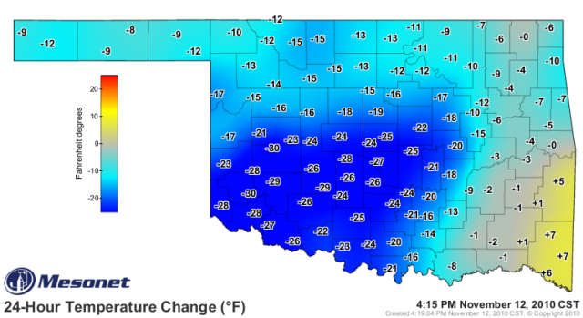
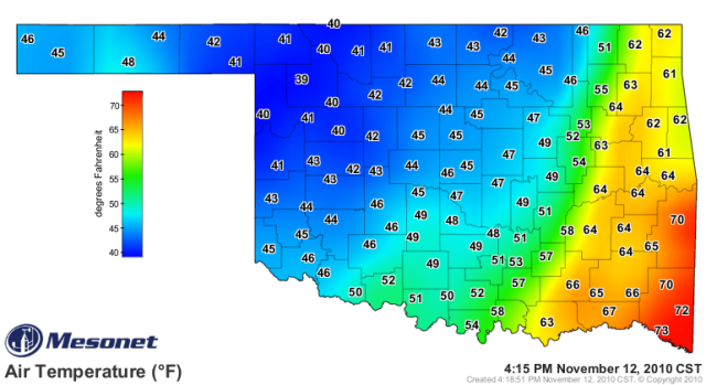
Yeah, this was definitely the first "true" cold front of the season (a.k.a. very noticeable as it came through). Yesterday we were in the 70s for highs, and this afternoon it is just 46-47F with gusty north winds and overcast skies.Portastorm wrote:Gotta love these strong autumn fronts ... at 2 p.m., it is 37 degrees in Amarillo and at the other end of the state, Brownsville, it is almost 50 degrees warmer at 84 degrees!
24-hour temperature change (Oklahoma): http://i43.photobucket.com/albums/e371/ ... 1289600648
4:15pm temperatures (Oklahoma): http://i43.photobucket.com/albums/e371/ ... grad-1.png
0 likes
-
TwisterFanatic

- Category 5
- Posts: 1041
- Joined: Mon Jun 28, 2010 12:43 pm
- Location: Sallisaw, Oklahoma
Cold front is moving in on me. 67 degrees here and 49 just 25 miles to the west. Very noticeable front.
0 likes
Personal Forecast Disclaimer:
The posts in this forum are NOT official forecast and should not be used as such. They are just the opinion of the poster and may or may not be backed by sound meteorological data. They are NOT endorsed by any professional institution or storm2k.org. For official information, please refer to the NHC and NWS products.
The posts in this forum are NOT official forecast and should not be used as such. They are just the opinion of the poster and may or may not be backed by sound meteorological data. They are NOT endorsed by any professional institution or storm2k.org. For official information, please refer to the NHC and NWS products.
-
Extremeweatherguy
- Category 5
- Posts: 11095
- Joined: Mon Oct 10, 2005 8:13 pm
- Location: Florida
Check out the snow they got over in Amarillo, TX today..
http://www.youtube.com/watch?v=7WfqePbYylQ
http://www.youtube.com/watch?v=oDTLBcpAX4w
http://www.youtube.com/watch?v=7WfqePbYylQ
http://www.youtube.com/watch?v=oDTLBcpAX4w
0 likes
Re: Winter 2010-11 for the Southern Plains
Wow thats quite a snow storm for early november. Lucky them.
0 likes
Wow I thought they only got a dusting, that's definitely more than that. But then again it is Amarillo...I'm guessing they will have several big ones with panhandle hookers being a common in La Nina.
Heard reports of 3-5 inches in the panhandle, can anyone confirm that?
Heard reports of 3-5 inches in the panhandle, can anyone confirm that?
0 likes
The above post and any post by Ntxw is NOT an official forecast and should not be used as such. It is just the opinion of the poster and may or may not be backed by sound meteorological data. It is NOT endorsed by any professional institution including Storm2k. For official information, please refer to NWS products.
Help support Storm2K!
Help support Storm2K!
-
Texas2Florida

- Tropical Depression

- Posts: 71
- Joined: Thu Dec 03, 2009 12:17 am
- Location: NE Pennsylvania backwoods
-
Extremeweatherguy
- Category 5
- Posts: 11095
- Joined: Mon Oct 10, 2005 8:13 pm
- Location: Florida
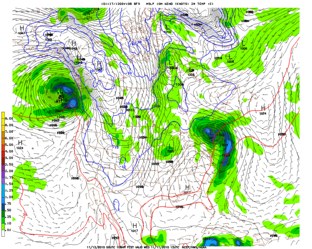
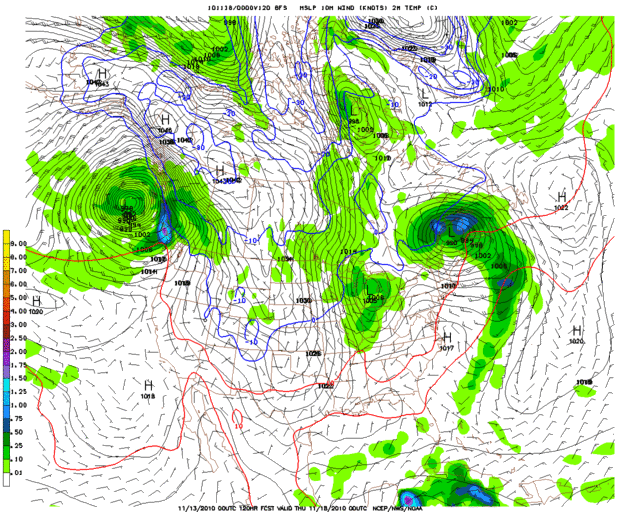
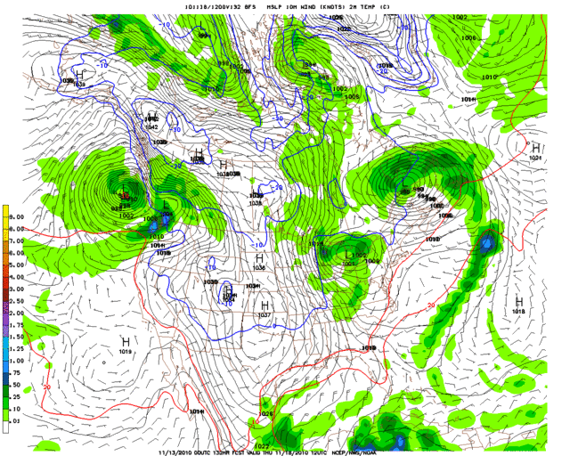
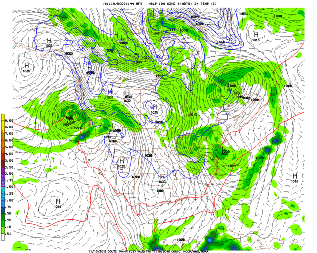
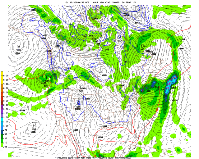
The 00z GFS looks like it might be getting a better handle on next week's first wave (second if this weekend is include) of cold. By Tuesday evening into Wednesday morning it has a 1048mb+ high building in western canada, while a low pressure axis across the plains is starting to drag a cold front south into western Kansas and the Oklahoma panhandle. The cold front then races south through Texas during the day on Wednesday, with the 0C 850mb line pushing into south-central Oklahoma by Wednesday evening. On Thursday morning the surface freezing line is well south into Oklahoma, with an axis of high pressure (1030mb+) stretching from the southern plains up into Canada. The high temperature Thursday afternoon struggles to top the lower 50s all the way to Dallas, with Oklahoma stuck in the 40s (under sunny skies). The cold starts shifting east Friday, but not before bringing a good chunk of Oklahoma and northeast Texas another freeze.
2-meter temperature, 6-hr precipitation, and SLP:
WED 6AM - http://i43.photobucket.com/albums/e371/ ... 108l-2.gif
WED 6PM - http://i43.photobucket.com/albums/e371/ ... 120l-3.gif
THU 6AM - http://i43.photobucket.com/albums/e371/ ... 132l-1.gif
THU 6PM - http://i43.photobucket.com/albums/e371/ ... n_144l.gif
FRI 6AM - http://i43.photobucket.com/albums/e371/ ... n_156l.gif
While not overly cold, especially compared to December/January cold snaps, this is still much colder than what was shown on the 12z GFS run; and probably more akin to what may actually take place mid next week. There might also be even colder airmasses to deal with as we head towards Thanksgiving week as well, but it is still too early to tell for sure. The models continue to flip flop on that issue a bit (see earlier post). It is worth noting that the latest "flip" of the GFS is back towards a cold Thanksgiving week though.
(11/13/10 10:30am Update: The 12z GFS now looks a little warmer for mid next week again. Still a nice shot of chilly air, but not near as chilly as on the 00z run. Geez.. Why do I even bother posting model analysis beyond 3-4 days out anymore..? lol)
2-meter temperature, 6-hr precipitation, and SLP:
WED 6AM - http://i43.photobucket.com/albums/e371/ ... 108l-2.gif
WED 6PM - http://i43.photobucket.com/albums/e371/ ... 120l-3.gif
THU 6AM - http://i43.photobucket.com/albums/e371/ ... 132l-1.gif
THU 6PM - http://i43.photobucket.com/albums/e371/ ... n_144l.gif
FRI 6AM - http://i43.photobucket.com/albums/e371/ ... n_156l.gif
While not overly cold, especially compared to December/January cold snaps, this is still much colder than what was shown on the 12z GFS run; and probably more akin to what may actually take place mid next week. There might also be even colder airmasses to deal with as we head towards Thanksgiving week as well, but it is still too early to tell for sure. The models continue to flip flop on that issue a bit (see earlier post). It is worth noting that the latest "flip" of the GFS is back towards a cold Thanksgiving week though.
(11/13/10 10:30am Update: The 12z GFS now looks a little warmer for mid next week again. Still a nice shot of chilly air, but not near as chilly as on the 00z run.
Last edited by Extremeweatherguy on Sat Nov 13, 2010 11:26 am, edited 1 time in total.
0 likes
-
gboudx

- S2K Supporter
- Posts: 4090
- Joined: Thu Sep 04, 2003 1:39 pm
- Location: Rockwall, Tx but from Harvey, La
Excerpt from AM DFW AFD.
BOTH THE ECMWF AND THE GFS ARE INDICATING A POSSIBLE PATTERN
SHIFT DURING THE FIRST PART OF THE WEEK OF THANKSGIVING WITH A
HIGH AMPLITUDE RIDGE BUILDING OFF THE WEST COAST. THIS PATTERN IS
USUALLY ASSOCIATED WITH AN INTRUSION OF VERY COLD AIR ACROSS THE
PLAINS. OF COURSE...THIS IS A FEW DAYS BEYOND THIS FORECAST CYCLE...
BUT A PATTERN SUCH AS THIS USUALLY BRINGS A WIDE SPREAD FREEZE TO
THE REGION. THEREFORE...WILL BE KEEPING A CLOSE EYE ON THE LARGE
SCALE PATTERN IN THE COMING DAYS.
0 likes
-
srainhoutx
- S2K Supporter
- Posts: 6919
- Age: 68
- Joined: Sun Jan 14, 2007 11:34 am
- Location: Haywood County, NC
- Contact:
Re: Winter 2010-11 for the Southern Plains
San Angelo snip...
JUST BEYOND THE FORECAST
PACKAGE...MODELS ARE HINTING AT A MUCH STRONGER COLD FRONT MOVING
INTO THE REGION...AT THE BEGINNING OF THE WEEK OF THANKSGIVING.
JUST BEYOND THE FORECAST
PACKAGE...MODELS ARE HINTING AT A MUCH STRONGER COLD FRONT MOVING
INTO THE REGION...AT THE BEGINNING OF THE WEEK OF THANKSGIVING.
0 likes
Carla/Alicia/Jerry(In The Eye)/Michelle/Charley/Ivan/Dennis/Katrina/Rita/Wilma/Ike/Harvey
Member: National Weather Association
Wx Infinity Forums
http://wxinfinity.com/index.php
Facebook.com/WeatherInfinity
Twitter @WeatherInfinity
Member: National Weather Association
Wx Infinity Forums
http://wxinfinity.com/index.php
Facebook.com/WeatherInfinity
Twitter @WeatherInfinity
-
Portastorm
- Storm2k Moderator
- Posts: 9954
- Age: 63
- Joined: Fri Jul 11, 2003 9:16 am
- Location: Round Rock, TX
- Contact:
Re: Winter 2010-11 for the Southern Plains
The crazy Canadian (today's 0z run) is on board as well although it holds the mean trough position more over the Great Lakes and Mississippi Valley as compared to the GFS and Euro.
http://raleighwx.easternuswx.com/models/ggem/00zggem500mbHGHTNA240.gif
http://raleighwx.easternuswx.com/models/ggem/00zggem500mbHGHTNA240.gif
0 likes
-
NY NJ PA Weather
- Professional-Met

- Posts: 22
- Age: 46
- Joined: Fri Sep 10, 2010 9:39 am
- Location: Freehold, New Jersey
- Contact:
Re: Winter 2010-11 for the Southern Plains
Thus far my ideas for the Northern Plains and Great Lakes is starting to work out like clock work from my thoughts in September and October.
The Arctic/Polar air masses are rapidly building over western Canada and all guidance agrees on the cold shot into the Northern Plains and Great Lakes over the next 7 to 10 days. Now going forward there should be a lot of volatility. Don't buy into solutions where the cold air masses get into the Southeast. Not with the ridge support around the Bahamas. No way.
However, I would keep an eye on the Southern Plains around Thanksgiving for a shallow assault of Arctic air that may create havoc for travel. As for the Northeast and Northern Mid Atlantic, the battle lines will start to be drawn. The NAO will continue to remain negative with higher heights becoming established over Greenland and around the Barren Sea. Moving into December, I expect the PV to be forced south and southeast towards Eastern Canada while Arctic air dominates from the Pacific Northwest through the Rockies, the Northern Plains, Great Lakes and New England. Tight thermal gradient develops from the Southern Plains through the Mississippi Valley, Tennessee and Ohio Valleys, and the Mid Atlantic. Train of storms follow. Details foggy (no pun intended) but I like the set up.
Oh yeah, and that La Nina that everyone was saying west based by now is not tanking in Niño 1+2 &3 while warming rapidly in Niño 3.4 and 4. Love it when a forecast works out, especially when one uses physics and dynamic meteorology!
0 likes
Let the Water Vapor Satellite lead the way!
-
Extremeweatherguy
- Category 5
- Posts: 11095
- Joined: Mon Oct 10, 2005 8:13 pm
- Location: Florida
Who is online
Users browsing this forum: No registered users and 76 guests