

Its western side is very flat at the moment so looks like shear is still a problem at the moment.
What we don't want is the system to track further west and then strengthen last minute.
WPAC: SONGDA - Tropical Depression (1102/04W)
Moderator: S2k Moderators
0 likes
Personal Forecast Disclaimer:
The posts in this forum are NOT official forecast and should not be used as such. They are just the opinion of the poster and may or may not be backed by sound meteorological data. They are NOT endorsed by any professional institution or storm2k.org. For official information, please refer to the NHC and NWS products
The posts in this forum are NOT official forecast and should not be used as such. They are just the opinion of the poster and may or may not be backed by sound meteorological data. They are NOT endorsed by any professional institution or storm2k.org. For official information, please refer to the NHC and NWS products
-
oaba09
- S2K Supporter

- Posts: 1496
- Age: 39
- Joined: Thu Oct 01, 2009 10:02 am
- Location: Valenzuela, Philippines
- Contact:

<Analyses at 23/15 UTC>
Scale -
Intensity -
Center position N11°40'(11.7°)
E131°50'(131.8°)
Direction and speed of movement W 20km/h(10kt)
Central pressure 985hPa
Maximum wind speed near the center 25m/s(50kt)
Maximum wind gust speed 35m/s(70kt)
Area of 30kt winds or more NE280km(150NM)
SW200km(110NM)
<Forecast for 24/15 UTC>
Intensity Strong
Center position of probability circle N12°55'(12.9°)
E130°20'(130.3°)
Direction and speed of movement NW 10km/h(6kt)
Central pressure 965hPa
Maximum wind speed near the center 35m/s(70kt)
Maximum wind gust speed 50m/s(100kt)
Radius of probability circle 130km(70NM)
Storm warning area Wide 240km(130NM)
<Forecast for 25/12 UTC>
Intensity Strong
Center position of probability circle N14°35'(14.6°)
E128°25'(128.4°)
Direction and speed of movement NW 15km/h(7kt)
Central pressure 950hPa
Maximum wind speed near the center 40m/s(80kt)
Maximum wind gust speed 60m/s(115kt)
Radius of probability circle 200km(110NM)
Storm warning area Wide 330km(180NM)
<Forecast for 26/12 UTC>
Intensity Very Strong
Center position of probability circle N16°25'(16.4°)
E126°00'(126.0°)
Direction and speed of movement NW 15km/h(7kt)
Central pressure 940hPa
Maximum wind speed near the center 45m/s(85kt)
Maximum wind gust speed 60m/s(120kt)
Radius of probability circle 300km(160NM)
Storm warning area Wide 460km(250NM)
<Forecast for 27/12 UTC>
Center position of probability circle N19°30'(19.5°)
E124°25'(124.4°)
Direction and speed of movement NNW 15km/h(9kt)
Radius of probability circle 440km(240NM)
<Forecast for 28/12 UTC>
Center position of probability circle N24°40'(24.7°)
E127°20'(127.3°)
Direction and speed of movement NNE 30km/h(15kt)
Radius of probability circle 560km(300NM)
0 likes
-
oaba09
- S2K Supporter
- Posts: 1496
- Age: 39
- Joined: Thu Oct 01, 2009 10:02 am
- Location: Valenzuela, Philippines
- Contact:
Latest from PAGASA:

Tropical Storm "CHEDENG" has maintained its strength as it continues to move West Northwestward.
Location of Center:
(as of 10:00 p.m.) 640 kms East of Borongan, Eastern Samar
Coordinates: 11.7°N, 131.9°E
Strength: Maximum sustained winds of 95 kph near the center and gustiness of up to 120 kph
Movement: West Northwest at 17 kph
Forecast Positions/Outlook: Tuesday evening:
360 kms Northeast of Borongan, Eastern Samar
Wednesday evening:
380 km North of Borongan, Eastern Samar or
200 km North Northeast of Virac, Catanduanes
Thursday evening:
80 km Northeast of Tuguegarao City
0 likes
-
RobWESTPACWX
- WestPACMet

- Posts: 1616
- Joined: Fri Sep 17, 2010 2:26 am
- Location: Tokyo, Japan
- Contact:
Re: WPAC: SONGDA - Severe Tropical Storm (1102/04W)
My personal thoughts on this system is that it will track along the NE coast of Luzon before taking off to the N. This is not only because the model consensus are showing it around that region but the streamline analysis is also depicting a weakness in the sub-tropical ridge in that region.
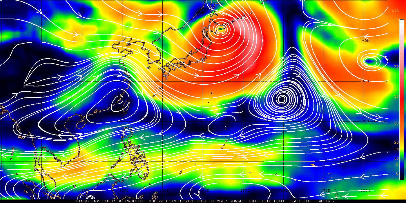
This would be bad news for the region though as they are still recovering from Aere that hit the area just over a week ago. But as far as it going across the island into the SCS I think that is out of the question.
As far as Okinawa (kadena fcst below) thoughts here are that is will defiantly hit the island in some sort of fashion once it gets wrapped up in the westerlies, now will it be a typhoon or a TS strength winds over the island that is still uncertain, but I would look for a upgrade in the TC COR of Kadena in the next 24-36 hours.
Just my thoughts though.
0 likes
Satellites, Charts and Forecasting tools for East Asia at WESTERNPACIFICWEATHER.COM
I suspect this is one of those classic systems that the models expected it to ramp up quicker then it has and thus go northwards sooner...instead its remained surpressed by shear and thus keeps trucking W/WNW.
Rob, I agree, though I wouldn't bew shocked if the models keep trending westwards over the next 24hrs.
Rob, I agree, though I wouldn't bew shocked if the models keep trending westwards over the next 24hrs.
0 likes
Personal Forecast Disclaimer:
The posts in this forum are NOT official forecast and should not be used as such. They are just the opinion of the poster and may or may not be backed by sound meteorological data. They are NOT endorsed by any professional institution or storm2k.org. For official information, please refer to the NHC and NWS products
The posts in this forum are NOT official forecast and should not be used as such. They are just the opinion of the poster and may or may not be backed by sound meteorological data. They are NOT endorsed by any professional institution or storm2k.org. For official information, please refer to the NHC and NWS products
-
RobWESTPACWX
- WestPACMet
- Posts: 1616
- Joined: Fri Sep 17, 2010 2:26 am
- Location: Tokyo, Japan
- Contact:
Re: WPAC: SONGDA - Severe Tropical Storm (1102/04W)
You can really see the dry air entrainment that has been having an effect on this system with the loop below.

0 likes
Satellites, Charts and Forecasting tools for East Asia at WESTERNPACIFICWEATHER.COM
-
RobWESTPACWX
- WestPACMet
- Posts: 1616
- Joined: Fri Sep 17, 2010 2:26 am
- Location: Tokyo, Japan
- Contact:
Re: WPAC: SONGDA - Severe Tropical Storm (1102/04W)
Has weakened per JTWC now,

0 likes
Satellites, Charts and Forecasting tools for East Asia at WESTERNPACIFICWEATHER.COM
-
RobWESTPACWX
- WestPACMet
- Posts: 1616
- Joined: Fri Sep 17, 2010 2:26 am
- Location: Tokyo, Japan
- Contact:
Re: WPAC: SONGDA - Severe Tropical Storm (1102/04W)
Models in a much tighter agreement now of a track just off of NE Luzon.

0 likes
Satellites, Charts and Forecasting tools for East Asia at WESTERNPACIFICWEATHER.COM
-
P.K.

- Professional-Met

- Posts: 5149
- Joined: Thu Sep 23, 2004 5:57 pm
- Location: Watford, England
- Contact:
Re: WPAC: SONGDA - Severe Tropical Storm (1102/04W)
55kts at 18Z.
WTPQ20 RJTD 231800
RSMC TROPICAL CYCLONE ADVISORY
NAME STS 1102 SONGDA (1102)
ANALYSIS
PSTN 231800UTC 11.7N 131.5E FAIR
MOVE W 10KT
PRES 980HPA
MXWD 055KT
GUST 080KT
50KT 30NM
30KT 150NM NORTHEAST 110NM SOUTHWEST
FORECAST
24HF 241800UTC 12.9N 129.4E 70NM 70%
MOVE WNW 06KT
PRES 960HPA
MXWD 075KT
GUST 105KT
48HF 251800UTC 14.6N 127.0E 110NM 70%
MOVE NW 07KT
PRES 945HPA
MXWD 080KT
GUST 115KT
72HF 261800UTC 16.7N 124.4E 160NM 70%
MOVE NW 08KT
PRES 935HPA
MXWD 085KT
GUST 120KT =
0 likes
-
RobWESTPACWX
- WestPACMet
- Posts: 1616
- Joined: Fri Sep 17, 2010 2:26 am
- Location: Tokyo, Japan
- Contact:
Re: WPAC: SONGDA - Severe Tropical Storm (1102/04W)
Another Video posted my partner here Pat, great video update.
[youtube]http://www.youtube.com/watch?v=ykJt0gBA2Kc[/youtube]
[youtube]http://www.youtube.com/watch?v=ykJt0gBA2Kc[/youtube]
0 likes
Satellites, Charts and Forecasting tools for East Asia at WESTERNPACIFICWEATHER.COM
A weaker system right now probably means this one makes actyual landfall on Luzon rather then just stay offshore. Will have to wait and see, I'd be a little surprised if it doesn't get above 65kts at some point.
0 likes
Personal Forecast Disclaimer:
The posts in this forum are NOT official forecast and should not be used as such. They are just the opinion of the poster and may or may not be backed by sound meteorological data. They are NOT endorsed by any professional institution or storm2k.org. For official information, please refer to the NHC and NWS products
The posts in this forum are NOT official forecast and should not be used as such. They are just the opinion of the poster and may or may not be backed by sound meteorological data. They are NOT endorsed by any professional institution or storm2k.org. For official information, please refer to the NHC and NWS products


Re:
Infdidoll wrote:I'm hearing two different predictions here: Some seem very confident this is a landfall on Luzon, others supporting Songda staying off to the NE. If I were a betting person, typhoon betting would be better than Vegas.
right now both JTWC and JMA have it staying offshore of PI and coming your direction - maybe east of or maybe west of - could go either way. You are wise to prepare early and avoid the lines. If I had to pick a spot to fly to and film, right now, I'd pick somewhere close to Okinawa - it's in the lane.
0 likes
-
rdhdstpchld
- Tropical Depression

- Posts: 79
- Joined: Mon May 09, 2011 3:47 am
Re: Re:
JTE50 wrote:Infdidoll wrote:I'm hearing two different predictions here: Some seem very confident this is a landfall on Luzon, others supporting Songda staying off to the NE. If I were a betting person, typhoon betting would be better than Vegas.
right now both JTWC and JMA have it staying offshore of PI and coming your direction - maybe east of or maybe west of - could go either way. You are wise to prepare early and avoid the lines. If I had to pick a spot to fly to and film, right now, I'd pick somewhere close to Okinawa - it's in the lane.
I'd pick Ishigaki...there's a club med there at least...
0 likes
-
rdhdstpchld
- Tropical Depression
- Posts: 79
- Joined: Mon May 09, 2011 3:47 am
Re: WPAC: SONGDA - Severe Tropical Storm (1102/04W)
Infdidoll wrote:rdhdstpchld wrote:New here - just a random deployed spouse sitting on Okinawa watching another holiday weekend go down the crapper...LOL. At least it will be more than just crummy rainstorms...Infidoll - agreed on the commissary thing...tho it's funny to watch the locals chuckle at us as we stock up. They don't shut down until the eye is upon us...I on the other hand, will have kids in house for three days prior and after - and probably miss a few days of school out of the deal too...blech
Welcome!Glad to have more military folks around here to contribute to the discussion! This site has the best info from meteorologists and enthusiasts so it's a great "go to" reference if you like analysis. I hear ya on restless kids! I've got a 4 & 5 year-old and they are going to be upset about being inside. Of course, the locals will be out there surfing in it! We live right on the sea wall and sit and watch people actually out there in the water during some of these storms. LOL I did post a fair warning on the Kadena Facebook page so those people going away on vacation this week have some adequate time to get their stuff together. This storm is coming right when a lot of people are leaving to go back to the States to visit.
Thanks - I love the analysis -- been lurking since we got here 2yrs ago (wow!) -- we had a typhoon hit the day our movers brought our stuff - I was in awe that they were still planning to come. I have noticed the bugs seem to be a ton more active these past couple of days...it's like they *know*
0 likes
Re: Re:
rdhdstpchld wrote:JTE50 wrote:Infdidoll wrote:I'm hearing two different predictions here: Some seem very confident this is a landfall on Luzon, others supporting Songda staying off to the NE. If I were a betting person, typhoon betting would be better than Vegas.
right now both JTWC and JMA have it staying offshore of PI and coming your direction - maybe east of or maybe west of - could go either way. You are wise to prepare early and avoid the lines. If I had to pick a spot to fly to and film, right now, I'd pick somewhere close to Okinawa - it's in the lane.
I'd pick Ishigaki...there's a club med there at least...
I stayed at a Club Med in Sardinia - it was a fortress, ride out a storm in it any day.
I suspect the locals in Okinawa (like a lot of places that get hit a lot) know the drill and don't fret it too much. I was in Tulum, Mexico for Emily in 2005 and the locals started boarding up the windows about 12 hours before the storm. Nobody was too excited, just methodical. If your on base housing is like that at Andersen AFB on Guam, then you can handle 105 knots just fine. I would stash the car somewhere else though. And hopefully you are well above sea level. Andersen is on a cliff so they don't have to worry about storm surge/big waves.
0 likes
Re: WPAC: SONGDA - Severe Tropical Storm (1102/04W)
rdhdstpchld wrote:Infdidoll wrote:rdhdstpchld wrote:New here - just a random deployed spouse sitting on Okinawa watching another holiday weekend go down the crapper...LOL. At least it will be more than just crummy rainstorms...Infidoll - agreed on the commissary thing...tho it's funny to watch the locals chuckle at us as we stock up. They don't shut down until the eye is upon us...I on the other hand, will have kids in house for three days prior and after - and probably miss a few days of school out of the deal too...blech
Welcome!
Thanks - I love the analysis -- been lurking since we got here 2yrs ago (wow!) -- we had a typhoon hit the day our movers brought our stuff - I was in awe that they were still planning to come. I have noticed the bugs seem to be a ton more active these past couple of days...it's like they *know*
I got really interesting video of all the dragonflies swarming once before a typhoon hit a few years ago. I've heard they can sense a change in pressure in the air. Pretty neat stuff.
0 likes
Re: Re:
JTE50 wrote:Infdidoll wrote:I'm hearing two different predictions here: Some seem very confident this is a landfall on Luzon, others supporting Songda staying off to the NE. If I were a betting person, typhoon betting would be better than Vegas.
right now both JTWC and JMA have it staying offshore of PI and coming your direction - maybe east of or maybe west of - could go either way. You are wise to prepare early and avoid the lines. If I had to pick a spot to fly to and film, right now, I'd pick somewhere close to Okinawa - it's in the lane.
I trust JTWC & JMA. PAGASA always seems to predict in favor of storms hitting the Philippines. Maybe they're playing safe, but for accuracy, JTWC seems to be the agency of choice for how it will impact the overall region, not just in the interest of one continent or prefecture.
0 likes
-
oaba09
- S2K Supporter
- Posts: 1496
- Age: 39
- Joined: Thu Oct 01, 2009 10:02 am
- Location: Valenzuela, Philippines
- Contact:
Re: WPAC: SONGDA - Severe Tropical Storm (1102/04W)
STS 1102 (Songda)
Issued at 00:50 UTC, 24 May 2011
<Analyses at 24/00 UTC>
Scale -
Intensity -
Center position N11°55'(11.9°)
E131°10'(131.2°)
Direction and speed of movement WNW Slowly
Central pressure 980hPa
Maximum wind speed near the center 30m/s(55kt)
Maximum wind gust speed 40m/s(80kt)
Area of 50kt winds or more Wide 60km(30NM)
Area of 30kt winds or more NE280km(150NM)
SW200km(110NM)
<Forecast for 25/00 UTC>
Intensity Strong
Center position of probability circle N12°55'(12.9°)
E128°30'(128.5°)
Direction and speed of movement WNW 15km/h(7kt)
Central pressure 960hPa
Maximum wind speed near the center 40m/s(75kt)
Maximum wind gust speed 55m/s(105kt)
Radius of probability circle 130km(70NM)
Storm warning area Wide 260km(140NM)
<Forecast for 26/00 UTC>
Intensity Strong
Center position of probability circle N14°30'(14.5°)
E125°55'(125.9°)
Direction and speed of movement WNW 15km/h(7kt)
Central pressure 945hPa
Maximum wind speed near the center 40m/s(80kt)
Maximum wind gust speed 60m/s(115kt)
Radius of probability circle 200km(110NM)
Storm warning area Wide 350km(190NM)
<Forecast for 27/00 UTC>
Intensity Very Strong
Center position of probability circle N16°55'(16.9°)
E123°25'(123.4°)
Direction and speed of movement NW 15km/h(8kt)
Central pressure 935hPa
Maximum wind speed near the center 45m/s(85kt)
Maximum wind gust speed 60m/s(120kt)
Radius of probability circle 300km(160NM)
Storm warning area Wide 480km(260NM)
0 likes
Who is online
Users browsing this forum: No registered users and 17 guests