Development on either side of Central A? (Is invest 97L)

This is the general tropical discussion area. Anyone can take their shot at predicting a storms path.

Moderator: S2k Moderators

Forum rules

The posts in this forum are NOT official forecasts and should not be used as such. They are just the opinion of the poster and may or may not be backed by sound meteorological data. They are NOT endorsed by any professional institution or STORM2K. For official information, please refer to products from the National Hurricane Center and National Weather Service.

Help Support Storm2K
Message
Author
User avatar
Rgv20
S2K Supporter
S2K Supporter
Posts: 2466
Age: 39
Joined: Wed Jan 05, 2011 5:42 pm
Location: Edinburg/McAllen Tx

#21 Postby Rgv20 » Sun Jul 10, 2011 2:45 pm

Its going to be a big mess in Central America late this week going into the weekend.

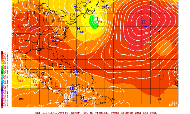
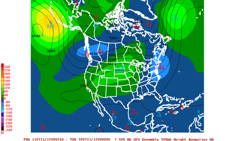
12zECMWF Saturday Morning
Image

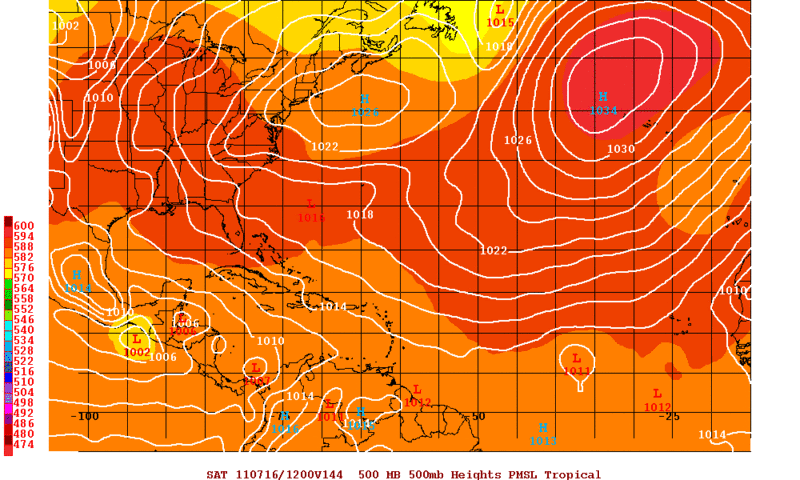
12zGFS Saturday Morning
Image

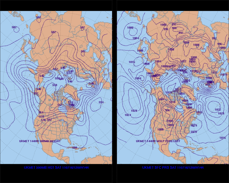
12zUKMET Saturday Morning
Image
0 likes   
The following post is NOT an official forecast and should not be used as such. It is just the opinion of the poster and may or may not be backed by sound meteorological data. It is NOT endorsed by any professional institution including storm2k.org For Official Information please refer to the NHC and NWS products.

User avatar
cycloneye
Admin
Admin
Posts: 145452
Age: 68
Joined: Thu Oct 10, 2002 10:54 am
Location: San Juan, Puerto Rico

Re: Posible development on either side of Centralamerica?

#22 Postby cycloneye » Sun Jul 10, 2011 5:20 pm

Yikes Macrocane! No change to the very wet scenario for that part of the world.

EPAC discussion at 22:05 UTC

LOOKING AHEAD...A TROPICAL WAVE IN THE CENTRAL CARIBBEAN WILL
MOVE INTO THE W CARIBBEAN THROUGH TUE...CROSS THE YUCATAN
PENINSULA TUE AND TUE NIGHT...THEN ACROSS THE BAY OF CAMPECHE
WED AND THU. THE MONSOON TROUGH IS EXPECTED TO SHIFT NORTHWARD
IN RESPONSE TO THE TROPICAL WAVE AND EXTEND FROM SOUTHERN MEXICO
ACROSS CENTRAL AMERICA BY MIDWEEK...WITH THE MONSOON TROUGH
BECOMING UNUSUALLY STRONG. ASSOCIATED WITH THIS UNUSUALLY STRONG
MONSOON TROUGH...A SURGE OF SW MONSOONAL FLOW WILL COMMENCE BY
MONDAY MORNING FROM 03N TO 07N BETWEEN 85W AND 100W WITH FRESH
TO STRONG WINDS EXPECTED. THE PERSISTENT FRESH TO STRONG SW
MONSOONAL FLOW WILL ALLOW SEAS TO BUILD TO 10-12 FT BY MON NIGHT
AND UP TO 13 FT BY TUE NIGHT OVER THE E PART OF THE AREA. MARINE
GUIDANCE SUGGESTS INCREASING WINDS TO 30 KT SOUTH OF COSTA RICA
AND PANAMA BY THU. PERSISTENT STRONG SW MONSOONAL FLOW WILL
BRING ABUNDANT TROPICAL MOISTURE INTO CENTRAL AMERICA AND
SOUTHERN MEXICO...POTENTIALLY GENERATING AREAS OF HEAVY RAINFALL
AND POSSIBLE MUDSLIDES OVER PORTIONS OF CENTRAL AMERICA AND
SOUTHERN MEXICO...ESPECIALLY FOR THE SECOND HALF OF THIS WEEK.
WE WILL CONTINUE MONITORING THE MEDIUM RANGE FORECAST ON THIS
POSSIBLE SCENARIO.

http://www.nhc.noaa.gov/text/refresh/MI ... 2149.shtml?
0 likes   
Visit the Caribbean-Central America Weather Thread where you can find at first post web cams,radars
and observations from Caribbean basin members Click Here

User avatar
cycloneye
Admin
Admin
Posts: 145452
Age: 68
Joined: Thu Oct 10, 2002 10:54 am
Location: San Juan, Puerto Rico

Re: Posible development on either side of Centralamerica?

#23 Postby cycloneye » Sun Jul 10, 2011 5:52 pm

The 18z GFS has almost the same as in past runs with two cyclones in the EPAC and SW Caribbean,although in this particular run,the EPAC side is somewhat less strong than the SW Caribbean.After it makes landfall in Nicaragua,it buries in Central America with more dumping of rain.In other words is a mess in the development front and on the rainy front for Central America.

Image

Uploaded by Imageshack.us
0 likes   
Visit the Caribbean-Central America Weather Thread where you can find at first post web cams,radars
and observations from Caribbean basin members Click Here

User avatar
ROCK
Category 5
Category 5
Posts: 9484
Age: 54
Joined: Tue Aug 17, 2004 7:30 am
Location: Kemah, Texas

Re: Posible development on either side of Central America?

#24 Postby ROCK » Sun Jul 10, 2011 6:33 pm

18Z NOGAPS holding to its guns with a farther north scenario....MY guess is where this (if anything) sets up shop will determine if it gets buried in CA or makes its way into the BOC.....I can say this...dont count on this death ridge over the NGOM to remain in the long range....it will break down...JMO

https://www.fnmoc.navy.mil/wxmap_cgi/cg ... t=Tropical
0 likes   

User avatar
Rgv20
S2K Supporter
S2K Supporter
Posts: 2466
Age: 39
Joined: Wed Jan 05, 2011 5:42 pm
Location: Edinburg/McAllen Tx

#25 Postby Rgv20 » Sun Jul 10, 2011 7:59 pm

By day 10 the 12zECMWF Ensembles are much weaker with the ridge than the operational run, just a wait and see scenario.

Image

Also 12zGFS Ensembles are hinting at a possible weakening of the ridge by day 11.

Image
0 likes   
The following post is NOT an official forecast and should not be used as such. It is just the opinion of the poster and may or may not be backed by sound meteorological data. It is NOT endorsed by any professional institution including storm2k.org For Official Information please refer to the NHC and NWS products.

User avatar
ROCK
Category 5
Category 5
Posts: 9484
Age: 54
Joined: Tue Aug 17, 2004 7:30 am
Location: Kemah, Texas

Re: Posible development on either side of Central America?

#26 Postby ROCK » Sun Jul 10, 2011 10:52 pm

https://www.fnmoc.navy.mil/wxmap_cgi/cg ... t=Tropical

0Z NOGAPS even farther north up the yucatan before turning into the BOC....
0 likes   

User avatar
Rgv20
S2K Supporter
S2K Supporter
Posts: 2466
Age: 39
Joined: Wed Jan 05, 2011 5:42 pm
Location: Edinburg/McAllen Tx

Re: Posible development on either side of Central America?

#27 Postby Rgv20 » Sun Jul 10, 2011 10:59 pm

ROCK wrote:https://www.fnmoc.navy.mil/wxmap_cgi/cgi-bin/wxmap_loop.cgi?&area=ngp_troplant&prod=z85&dtg=2011071000&set=Tropical

0Z NOGAPS even farther north up the yucatan before turning into the BOC....


That is yesterday 0z run, new 0z run should begin updating around 11:15 cdt.
0 likes   
The following post is NOT an official forecast and should not be used as such. It is just the opinion of the poster and may or may not be backed by sound meteorological data. It is NOT endorsed by any professional institution including storm2k.org For Official Information please refer to the NHC and NWS products.

User avatar
ROCK
Category 5
Category 5
Posts: 9484
Age: 54
Joined: Tue Aug 17, 2004 7:30 am
Location: Kemah, Texas

Re: Posible development on either side of Central America?

#28 Postby ROCK » Sun Jul 10, 2011 11:12 pm

Rgv20 wrote:
ROCK wrote:https://www.fnmoc.navy.mil/wxmap_cgi/cgi-bin/wxmap_loop.cgi?&area=ngp_troplant&prod=z85&dtg=2011071000&set=Tropical

0Z NOGAPS even farther north up the yucatan before turning into the BOC....


That is yesterday 0z run, new 0z run should begin updating around 11:15 cdt.


yep my bad....0z run now out afew hours.....
0 likes   

User avatar
South Texas Storms
Professional-Met
Professional-Met
Posts: 4227
Joined: Thu Jun 24, 2010 12:28 am
Location: Houston, TX

Re: Posible development on either side of Central America?

#29 Postby South Texas Storms » Sun Jul 10, 2011 11:23 pm

When do most models show cyclogeneis starting to occur?
0 likes   

User avatar
cycloneye
Admin
Admin
Posts: 145452
Age: 68
Joined: Thu Oct 10, 2002 10:54 am
Location: San Juan, Puerto Rico

Re: Posible development on either side of Central America?

#30 Postby cycloneye » Mon Jul 11, 2011 5:45 am

NOGAPS believe it or not has been the only model that has been persistant with developing in the Western Caribbean than the other models. Even GFS that was bullish for many runs,at 00z it was less enthusiastic.

http://moe.met.fsu.edu/cgi-bin/ngptc2.c ... =Animation
0 likes   
Visit the Caribbean-Central America Weather Thread where you can find at first post web cams,radars
and observations from Caribbean basin members Click Here

User avatar
GCANE
S2K Supporter
S2K Supporter
Posts: 11500
Joined: Mon Oct 22, 2007 8:03 am

Re: Posible development on either side of Central America?

#31 Postby GCANE » Mon Jul 11, 2011 9:24 am

Two strong hot-towers are firing off the east Nicaragua coast.


Image
0 likes   

User avatar
cycloneye
Admin
Admin
Posts: 145452
Age: 68
Joined: Thu Oct 10, 2002 10:54 am
Location: San Juan, Puerto Rico

Re: Posible development on either side of Central America?

#32 Postby cycloneye » Mon Jul 11, 2011 11:09 am

From EPAC discussion at 16:05 UTC:

A TROPICAL WAVE IN THE WESTERN CARIBBEAN ALONG 81W WILL CROSS
THE YUCATAN PENINSULA TUE AND THE BAY OF CAMPECHE TUE NIGHT
THROUGH THU. THE MONSOON TROUGH IS EXPECTED TO SHIFT NORTHWARD
IN RESPONSE TO THE TROPICAL WAVE AND EXTEND FROM SOUTHERN MEXICO
ACROSS CENTRAL AMERICA BY MID-WEEK...WITH THE MONSOON TROUGH
BECOMING UNUSUALLY STRONG. STRONG W-SW WINDS ARE EXPECTED N OF
05N E OF 94W WITH WINDS TO 30 KT LIKELY S OF BOTH GUATEMALA AND
COSTA RICA. PERSISTENT FRESH TO STRONG SW MONSOONAL FLOW WILL
ALLOW SEAS TO BUILD TO 10-12 FT MON NIGHT AND TO 13 FT TUE NIGHT
S OF CENTRAL AMERICA. ABUNDANT TROPICAL MOISTURE SURGING INTO
CENTRAL AMERICA AND SOUTHERN MEXICO HAS THE POTENTIAL TO
GENERATE HEAVY RAINFALL AND POSSIBLE MUDSLIDES OVER PORTIONS OF
CENTRAL AMERICA AND SOUTHERN MEXICO...ESPECIALLY TUE NIGHT
THROUGH FRI.
0 likes   
Visit the Caribbean-Central America Weather Thread where you can find at first post web cams,radars
and observations from Caribbean basin members Click Here

User avatar
cycloneye
Admin
Admin
Posts: 145452
Age: 68
Joined: Thu Oct 10, 2002 10:54 am
Location: San Juan, Puerto Rico

Re: Posible development on either side of Central America?

#33 Postby cycloneye » Mon Jul 11, 2011 11:36 am

Something taking shape near Nicaragua?

Image

Bouy 42057 reports pretty high gusts,but pressure is not very low.

http://www.ndbc.noaa.gov/station_page.php?station=42057
0 likes   
Visit the Caribbean-Central America Weather Thread where you can find at first post web cams,radars
and observations from Caribbean basin members Click Here

User avatar
Ivanhater
Storm2k Moderator
Storm2k Moderator
Posts: 11162
Age: 38
Joined: Fri Jul 01, 2005 8:25 am
Location: Pensacola

Re: Posible development on either side of Central America?

#34 Postby Ivanhater » Mon Jul 11, 2011 11:38 am

This area looks very interesting today.
0 likes   
Michael

User avatar
latitude_20
Tropical Storm
Tropical Storm
Posts: 196
Joined: Wed Jun 30, 2010 6:46 am
Location: Tulum, Mexico
Contact:

Re: Posible development on either side of Central America?

#35 Postby latitude_20 » Mon Jul 11, 2011 11:50 am

Yes it does - should make for an interesting next few days...
0 likes   

User avatar
KWT
Category 5
Category 5
Posts: 31415
Joined: Tue Aug 17, 2004 11:02 am
Location: UK!!!

#36 Postby KWT » Mon Jul 11, 2011 11:52 am

Does look quite interesting today!
0 likes   
Personal Forecast Disclaimer:
The posts in this forum are NOT official forecast and should not be used as such. They are just the opinion of the poster and may or may not be backed by sound meteorological data. They are NOT endorsed by any professional institution or storm2k.org. For official information, please refer to the NHC and NWS products

User avatar
GCANE
S2K Supporter
S2K Supporter
Posts: 11500
Joined: Mon Oct 22, 2007 8:03 am

Re: Posible development on either side of Central America?

#37 Postby GCANE » Mon Jul 11, 2011 11:53 am

A lot better looking then the 10% Yellow Circle IMHO.

Image

Image
0 likes   

User avatar
ROCK
Category 5
Category 5
Posts: 9484
Age: 54
Joined: Tue Aug 17, 2004 7:30 am
Location: Kemah, Texas

Re: Posible development on either side of Central America?

#38 Postby ROCK » Mon Jul 11, 2011 12:12 pm

anticyclone close to it....light shear
http://tropic.ssec.wisc.edu/real-time/w ... oom=&time=
0 likes   

Sanibel
Category 5
Category 5
Posts: 10375
Joined: Mon Aug 30, 2004 11:06 pm
Location: Offshore SW Florida

Re: Posible development on either side of Central America?

#39 Postby Sanibel » Mon Jul 11, 2011 12:37 pm

I think we have curvature in the disturbance over Honduras. This area has shown a tendency for development already this year. All depends on track.
0 likes   

User avatar
cycloneye
Admin
Admin
Posts: 145452
Age: 68
Joined: Thu Oct 10, 2002 10:54 am
Location: San Juan, Puerto Rico

Re: Posible development on either side of Central America?

#40 Postby cycloneye » Mon Jul 11, 2011 12:39 pm

NHC mentions it but.......

A LARGE AREA OF SHOWERS AND THUNDERSTORMS OVER THE WESTERN CARIBBEAN
SEA AND PORTIONS OF CENTRAL AMERICA IS ASSOCIATED WITH A TROPICAL
WAVE INTERACTING WITH AN UPPER-LEVEL LOW. DEVELOPMENT OF THIS
SYSTEM IS NOT EXPECTED DUE TO INTERACTION WITH LAND AND THIS SYSTEM
HAS A LOW CHANCE...NEAR 0 PERCENT...OF BECOMING A TROPICAL CYCLONE
DURING THE NEXT 48 HOURS. REGARDLESS OF DEVELOPMENT...HEAVY
RAINFALL ASSOCIATED WITH THIS SYSTEM WILL LIKELY CONTINUE OVER
PORTIONS OF CENTRAL AMERICA DURING THE NEXT COUPLE OF DAYS AS IT
MOVES WEST-NORTHWESTWARD AT 10 TO 15 MPH.


Image
0 likes   
Visit the Caribbean-Central America Weather Thread where you can find at first post web cams,radars
and observations from Caribbean basin members Click Here


Return to “Talkin' Tropics”

Who is online

Users browsing this forum: Google Adsense [Bot], LarryWx, REDHurricane and 27 guests