ATL: EMILY - Remnants
Moderator: S2k Moderators
- Evil Jeremy
- S2K Supporter

- Posts: 5463
- Age: 32
- Joined: Mon Apr 10, 2006 2:10 pm
- Location: Los Angeles, CA
The through comes through faster on this run. So future-Emily moves north out of the Caribbean faster, but becomes trapped by the rebuilding high. I can't tell if that is a good trend in the long run in terms of avoiding US impact or not.
EDIT: It sits and gets recurved by the next through, but I don't personally hold much faith in the GFS after it looses high resolution after 204 hours.
EDIT: It sits and gets recurved by the next through, but I don't personally hold much faith in the GFS after it looses high resolution after 204 hours.
0 likes
Frances 04 / Jeanne 04 / Katrina 05 / Wilma 05 / Fay 08 / Debby 12 / Andrea 13 / Colin 16 / Hermine 16 / Matthew 16 / Irma 17
- 'CaneFreak
- Category 5

- Posts: 1487
- Joined: Mon Jun 05, 2006 10:50 am
- Location: New Bern, NC
Re:
Agreed
Evil Jeremy wrote:The through comes through faster on this run. So future-Emily moves north out of the Caribbean faster, but becomes trapped by the rebuilding high. I can't tell if that is a good trend in the long run in terms of avoiding US impact or not.
EDIT: It sits and gets recurved by the next through, but I don't personally hold much faith in the GFS after it looses high resolution after 204 hours.
0 likes
- Rgv20
- S2K Supporter

- Posts: 2466
- Age: 39
- Joined: Wed Jan 05, 2011 5:42 pm
- Location: Edinburg/McAllen Tx
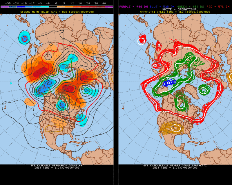
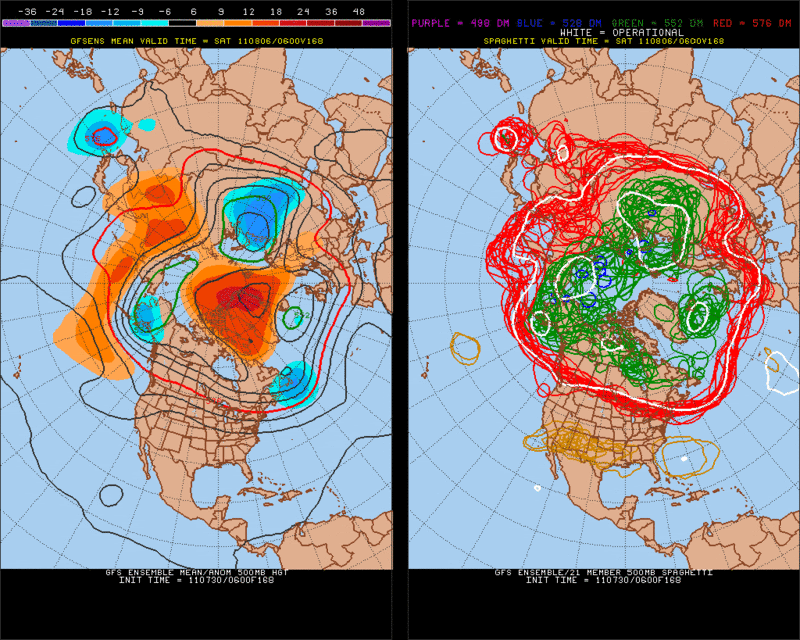
This could be a classic scenario where if the trough is not strong enough or 91l is not deep enough it would just cause a slow down to N/NW movement for a couple of days follow by a west movement if the 6zGFS Ensembles are correct.
By 96hrs you could can see the trough around Maine pulling on 91l.

By 168hrs the trough is on the process of lifting out albeit a slow one. But some of the Ensembles start to build a ridge east of Florida.

Of course this far out is just speculation but just something to keep an eye out.
By 96hrs you could can see the trough around Maine pulling on 91l.

By 168hrs the trough is on the process of lifting out albeit a slow one. But some of the Ensembles start to build a ridge east of Florida.

Of course this far out is just speculation but just something to keep an eye out.
0 likes
The following post is NOT an official forecast and should not be used as such. It is just the opinion of the poster and may or may not be backed by sound meteorological data. It is NOT endorsed by any professional institution including storm2k.org For Official Information please refer to the NHC and NWS products.
- ConvergenceZone
- Category 5

- Posts: 5241
- Joined: Fri Jul 29, 2005 1:40 am
- Location: Northern California
Re:
'CaneFreak wrote:Operational GFS:
http://mag.ncep.noaa.gov/GemPakTier/Mag ... ort_ht.gif
Ridge rebuilds over Northeastern US...NO recurve on this run folks
I don't know about that, whie I don't see it showing it recurving, I also don't show it hitting the USA either. Just kinda sitting out there in the Atlantic.
0 likes
- northjaxpro
- S2K Supporter

- Posts: 8900
- Joined: Mon Sep 27, 2010 11:21 am
- Location: Jacksonville, FL
Re: ATL: INVEST 91L - Discussion
plasticup wrote:This is going to be a great one to track. Does it beat the ridge and recurve into Bermuda, or does the ridge push back and slide it into the Carolinas? Or is the ridge extra strong, pushing it over Florida and into the Gulf? Regardless, this one has the potential to be a loooooong tracker with some really interesting steering.
I'm pumped.
Well, I am not pumped about the prospects of our fellow neighbors down in the NE Caribbean islands potentially staring down at this storm in a few days. This could get to be a potentially dangerous situation for them. I'm hope and pray for the best situation possible, but also hope those folks are preparing for the worst as this system likely heads their way within the next 72 hours.
But, I do agree with you that this tropical cyclone will be quite a fascinating one to monitor all next week. There are so many variables to factor in with this system, including the ones you mentioned plasticup. Everyone definitely needs to pay attention for sure all week long with the progress of future Emily.
Last edited by northjaxpro on Sat Jul 30, 2011 11:55 am, edited 2 times in total.
0 likes
NEVER, EVER SAY NEVER in the tropics and weather in general, and most importantly, with life itself!!
________________________________________________________________________________________
Fay 2008 Beryl 2012 Debby 2012 Colin 2016 Hermine 2016 Julia 2016 Matthew 2016 Irma 2017 Dorian 2019
________________________________________________________________________________________
Fay 2008 Beryl 2012 Debby 2012 Colin 2016 Hermine 2016 Julia 2016 Matthew 2016 Irma 2017 Dorian 2019
-
StormClouds63
- Category 2

- Posts: 583
- Age: 62
- Joined: Tue May 13, 2008 11:56 am
- Location: Southwest Louisiana
Re: ATL: INVEST 91L - Discussion
plasticup wrote:This is going to be a great one to track. Does it beat the ridge and recurve into Bermuda, or does the ridge push back and slide it into the Carolinas? Or is the ridge extra strong, pushing it over Florida and into the Gulf? Regardless, this one has the potential to be a loooooong tracker with some really interesting steering.
I'm pumped.
Of the 3 options you mentioned, it's probably scenario 1 (re-curve) ... if not, option 2 (EC threat)
0 likes
Re: ATL: INVEST 91L - Discussion
Bring on 2011, The science behind the madness begins....Each year we wait all year for these 3 upcoming month Aug-Oct..Maybe a few weeks early but here we go folks...We break down the models 4x a day, sleep little, conjecture alot but in the end its our unique passion that few quite understand...Emily in the making should certainly bring all that we do too the table...I look forward to everyones analysis..Stay safe and enjoy the ride...
0 likes
-
plasticup
Re: ATL: INVEST 91L - Discussion
Eh, I'm rooting against the recurve. Everyone loves them, but for those of us in Bermuda it's not so great.
Fun fact, my first ever hurricane was also called Emily. It whipped through Bermuda in 1987 before satellite communication and no one even knew it was coming. People were driving, sailing, out for walks, a cruise ship was trying to dock and then BOOM it's a hurricane. To this day, people are able to tell you exactly what they were doing when Emily showed up.
Fun fact, my first ever hurricane was also called Emily. It whipped through Bermuda in 1987 before satellite communication and no one even knew it was coming. People were driving, sailing, out for walks, a cruise ship was trying to dock and then BOOM it's a hurricane. To this day, people are able to tell you exactly what they were doing when Emily showed up.
0 likes
-
hurricaneCW
- Category 5

- Posts: 1799
- Joined: Wed Mar 03, 2010 6:20 am
- Location: Toms River, NJ
Re: ATL: INVEST 91L - Discussion
Just like with last season, I think we'll see a lot of close calls, I'm not saying anything about this invest until we get an actual system out of it. It's starting to get better organized on satellite though, more convection, some classic curvature, Emily is probably one of my favorite names so I hope it becomes a powerful system like 2005.
0 likes
- Bocadude85
- Category 5

- Posts: 2991
- Age: 39
- Joined: Mon Apr 18, 2005 2:20 pm
- Location: Honolulu,Hi
Re: ATL: INVEST 91L - Models
I wonder if we could see a track similar to hurricane David in 1979 perhaps a little north of his track and not as strong obviously.
0 likes
- 'CaneFreak
- Category 5

- Posts: 1487
- Joined: Mon Jun 05, 2006 10:50 am
- Location: New Bern, NC
http://www.ssd.noaa.gov/goes/flt/t2/flash-rgb.html
I believe I am seeing two low level centers in this case: one near 49W (will likely become emily at some point) and one near 45/46 west...this is going to slow the development process even further...I am beginning to think this thing is really going to take its time developing...lets see what they say at 2 pm...
I believe I am seeing two low level centers in this case: one near 49W (will likely become emily at some point) and one near 45/46 west...this is going to slow the development process even further...I am beginning to think this thing is really going to take its time developing...lets see what they say at 2 pm...
0 likes
- Evil Jeremy
- S2K Supporter

- Posts: 5463
- Age: 32
- Joined: Mon Apr 10, 2006 2:10 pm
- Location: Los Angeles, CA
Re: ATL: INVEST 91L - Models
Vorticity has vastly improved over the past 6 hours. Much more consolidated now:
6 Hours Ago:

Now:

91L is looking healthy this morning. I say the NHC raises their TWO to 80% in a half hour, though 90% wouldn't surprise me, given how unpredictable they have been this season.
EDIT: Had the images in the wrong order lol, fixed.
6 Hours Ago:

Now:

91L is looking healthy this morning. I say the NHC raises their TWO to 80% in a half hour, though 90% wouldn't surprise me, given how unpredictable they have been this season.
EDIT: Had the images in the wrong order lol, fixed.
Last edited by Evil Jeremy on Sat Jul 30, 2011 12:39 pm, edited 1 time in total.
0 likes
Frances 04 / Jeanne 04 / Katrina 05 / Wilma 05 / Fay 08 / Debby 12 / Andrea 13 / Colin 16 / Hermine 16 / Matthew 16 / Irma 17
- cycloneye
- Admin

- Posts: 149431
- Age: 69
- Joined: Thu Oct 10, 2002 10:54 am
- Location: San Juan, Puerto Rico
Re: ATL: INVEST 91L - Models
0 likes
Visit the Caribbean-Central America Weather Thread where you can find at first post web cams,radars
and observations from Caribbean basin members Click Here
and observations from Caribbean basin members Click Here
Re:
'CaneFreak wrote:http://www.ssd.noaa.gov/goes/flt/t2/flash-rgb.html
I believe I am seeing two low level centers in this case: one near 49W (will likely become emily at some point) and one near 45/46 west...this is going to slow the development process even further...I am beginning to think this thing is really going to take its time developing...lets see what they say at 2 pm...
good eye and I see it also....49W 12.8N out in front and another lagging behind. still has ways to go IMO...one of these will become the dominant one eventually.
0 likes
Re: ATL: INVEST 91L - Models
I suspect we'll be discussing the impacts on Emily from the high mountains of Hispainola in a couple of days, but in the short term PR and NE carib islands have some trouble on their hands it appears.
0 likes
- Tropics Guy
- Tropical Storm

- Posts: 167
- Age: 63
- Joined: Tue Aug 31, 2004 8:12 pm
- Location: Hallandale beach & Vero beach, FL
Re: ATL: INVEST 91L - Discussion
Overall structure is improving, though seems like the low pressure circulation is still stretched out east to west which may slow development in the interim, but still on its way to becoming a TD or Emily by tomorrow or sooner...................
http://www.ssd.noaa.gov/goes/flt/t2/loop-vis.html
TG
http://www.ssd.noaa.gov/goes/flt/t2/loop-vis.html
TG
0 likes
- ConvergenceZone
- Category 5

- Posts: 5241
- Joined: Fri Jul 29, 2005 1:40 am
- Location: Northern California
Re: ATL: INVEST 91L - Models
cycloneye wrote:12z CMC ends run in the northern Bahamas.
http://moe.met.fsu.edu/cgi-bin/cmctc2.c ... =Animation
That run is probably the most ominous yet, as far as getting closer to the east coast is concerned. While you can see a turn the last couple of frames, it's making it a much closer call then the other models runs. Interesting days ahead....
0 likes
Who is online
Users browsing this forum: No registered users and 21 guests


