
Pouch P17L in Eastern Atlantic -(Now Invest 97L)
Moderator: S2k Moderators
Forum rules

The posts in this forum are NOT official forecasts and should not be used as such. They are just the opinion of the poster and may or may not be backed by sound meteorological data. They are NOT endorsed by any professional institution or STORM2K. For official information, please refer to products from the National Hurricane Center and National Weather Service.
-
Brent
- S2K Supporter

- Posts: 38740
- Age: 37
- Joined: Sun May 16, 2004 10:30 pm
- Location: Tulsa Oklahoma
- Contact:
Re: Pouch P17L in Eastern Atlantic - 10%
Last edited by Brent on Thu Aug 18, 2011 2:26 am, edited 1 time in total.
0 likes
#neversummer

Re: Pouch P17L in Eastern Atlantic - 10%
I think I see some 940MB in there which would equate to a Cat 3-4 ...major disaster right there.... 
0 likes


Re:
sgastorm wrote:This solution would require a big evacuation from Florida northward. It would probably bring considerable winds far inland from Florida and northward too. Looks like 240 hour ECMWF is not far from Savannah and Charleston.
i hope it comes up this way ( when people are evacuated, i'm going to be at CofC That week
0 likes
Once I see the REDS and GREENS Converge on a Base Velocity. ... I'm There!!
This is NOT an Official Forecast....Just my Opinion. For official information, please refer to the NHC and NWS products.
HIGHLIGHTS : '13 El Reno Tornado : 2013 Storm Chaser Tour, Joaquin; SC flood event, Matthew '16, Lowcountry Snow storm Jan '18
This is NOT an Official Forecast....Just my Opinion. For official information, please refer to the NHC and NWS products.
HIGHLIGHTS : '13 El Reno Tornado : 2013 Storm Chaser Tour, Joaquin; SC flood event, Matthew '16, Lowcountry Snow storm Jan '18
-
SouthFLTropics

- Category 5

- Posts: 4258
- Age: 50
- Joined: Thu Aug 14, 2003 8:04 am
- Location: Port St. Lucie, Florida
Re: Pouch P17L in Eastern Atlantic - 10%
That track is very similar to Floyd in 99. Isn't 99 one of the analog years for this year. That would give the entire SE CONUS a scare and cause major evac headaches.
Sent from my DROID2 using Tapatalk
Sent from my DROID2 using Tapatalk
0 likes
Fourth Generation Florida Native
Personal Storm History: David 79, Andrew 92, Erin 95, Floyd 99, Irene 99, Frances 04, Jeanne 04, Wilma 05, Matthew 16, Irma 17, Ian 22, Nicole 22, Milton 24
Personal Storm History: David 79, Andrew 92, Erin 95, Floyd 99, Irene 99, Frances 04, Jeanne 04, Wilma 05, Matthew 16, Irma 17, Ian 22, Nicole 22, Milton 24
-
somethingfunny

- ChatStaff

- Posts: 3926
- Age: 37
- Joined: Thu May 31, 2007 10:30 pm
- Location: McKinney, Texas
I'll tell you right now a vast majority from Key West on up to Myrtle Beach remember Floyd and will decide not to evacuate based on one bad experience.
0 likes
I am not a meteorologist, and any posts made by me are not official forecasts or to be interpreted as being intelligent. These posts are just my opinions and are probably silly opinions.
-
Meso

- Category 5
- Posts: 1609
- Age: 39
- Joined: Mon Aug 09, 2004 12:14 pm
- Location: South Africa
- Contact:
Re: Pouch P17L in Eastern Atlantic - 10%
It's quite rare to see such agreement between models, especially on a storm that hasn't properly formed even.
The 00z CMC, GFS and EURO are almost all identify in their timing, strength and location, though consistency is the key.
It's definitely looking more and more like something big is going to develop and by the end of the weekend we should have a better idea on the situation. The waters around the Bahamas seem to be prime for strengthening, or at least that's what the models are seeing, they all seem to bomb the system in the 180-216 hour period.
0 likes
Re: Pouch P17L in Eastern Atlantic - 10%
Meso wrote:It's quite rare to see such agreement between models, especially on a storm that hasn't properly formed even.
The 00z CMC, GFS and EURO are almost all identify in their timing, strength and location, though consistency is the key.
It's definitely looking more and more like something big is going to develop and by the end of the weekend we should have a better idea on the situation. The waters around the Bahamas seem to be prime for strengthening, or at least that's what the models are seeing, they all seem to bomb the system in the 180-216 hour period.

0 likes
Once I see the REDS and GREENS Converge on a Base Velocity. ... I'm There!!
This is NOT an Official Forecast....Just my Opinion. For official information, please refer to the NHC and NWS products.
HIGHLIGHTS : '13 El Reno Tornado : 2013 Storm Chaser Tour, Joaquin; SC flood event, Matthew '16, Lowcountry Snow storm Jan '18
This is NOT an Official Forecast....Just my Opinion. For official information, please refer to the NHC and NWS products.
HIGHLIGHTS : '13 El Reno Tornado : 2013 Storm Chaser Tour, Joaquin; SC flood event, Matthew '16, Lowcountry Snow storm Jan '18
-
weatherguy2
- Tropical Depression

- Posts: 72
- Joined: Sun Aug 01, 2010 2:45 am
Re: Pouch P17L in Eastern Atlantic - 10%
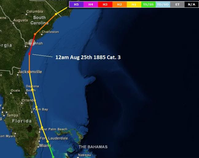
IF the 00z ECMWF came true, the last time a category 3 hurricane took a path like that was the morning of Aug. 25th 1885
Zoomed in 00z ECMWF:
Zoomed in 00z ECMWF:
0 likes


-
South Texas Storms

- Professional-Met

- Posts: 4257
- Joined: Thu Jun 24, 2010 12:28 am
- Location: Houston, TX
Re:
Turtle wrote:I've never tracked Hurricanes/Tropical Storms seriously, but is there a chance this event could shift 500+ miles West into Texas? This summer has been very event-less so I'm hoping for a change.
I'm hoping with ya Turtle but it doesn't look very likely at this time. I'm worried for our friends east of us but it is still over a week away...
0 likes

weatherguy2, that is actually spot on the ECM track.
So the ECM continues to flip-flop vbetwewen an explosive system and nearly nothing...wonderful for confidence!
And WHERE is the invest!
So the ECM continues to flip-flop vbetwewen an explosive system and nearly nothing...wonderful for confidence!
And WHERE is the invest!
0 likes
Personal Forecast Disclaimer:
The posts in this forum are NOT official forecast and should not be used as such. They are just the opinion of the poster and may or may not be backed by sound meteorological data. They are NOT endorsed by any professional institution or storm2k.org. For official information, please refer to the NHC and NWS products
The posts in this forum are NOT official forecast and should not be used as such. They are just the opinion of the poster and may or may not be backed by sound meteorological data. They are NOT endorsed by any professional institution or storm2k.org. For official information, please refer to the NHC and NWS products

-
Meso
- Category 5
- Posts: 1609
- Age: 39
- Joined: Mon Aug 09, 2004 12:14 pm
- Location: South Africa
- Contact:
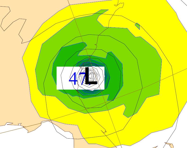
The 06z GFS is running late? Should have started 30 minutes ago, but nothing out yet.
But the 06z NAM has started showing P17 approaching PR as a 1008mb low in 84 hours!
EDIT: There it is, GFS run started coming through now 30 minutes later.
But the 06z NAM has started showing P17 approaching PR as a 1008mb low in 84 hours!
EDIT: There it is, GFS run started coming through now 30 minutes later.
Last edited by Meso on Thu Aug 18, 2011 5:07 am, edited 1 time in total.
0 likes

6Z GFS H+60 near 14/55...starting to organize...
http://raleighwx.americanwx.com/models/ ... cal060.gif
http://raleighwx.americanwx.com/models/ ... cal060.gif
0 likes
H+72 near Martinique..consistancy is outstanding!
http://raleighwx.americanwx.com/models/ ... cal072.gif
http://raleighwx.americanwx.com/models/ ... cal072.gif
0 likes
-
cycloneye

- Admin

- Posts: 149381
- Age: 69
- Joined: Thu Oct 10, 2002 10:54 am
- Location: San Juan, Puerto Rico
Re: Pouch P17L in Eastern Atlantic - 10%
And WHERE is the invest!
Good question KWT. I think they are waiting for convection to be plenty to then put it up.
0 likes
Visit the Caribbean-Central America Weather Thread where you can find at first post web cams,radars
and observations from Caribbean basin members Click Here
and observations from Caribbean basin members Click Here
Who is online
Users browsing this forum: No registered users and 120 guests