ATL : HARVEY - Tropical Depression - Discussion
Moderator: S2k Moderators
-
somethingfunny

- ChatStaff

- Posts: 3926
- Age: 37
- Joined: Thu May 31, 2007 10:30 pm
- Location: McKinney, Texas
Re: ATL : INVEST 93L - Discussion
93L has alot of pep, to use an unscientific word. I'm inclined to think it will ramp up very quickly once it forms an LLC... probably make landfall as a 60kt, 989mb tropical storm just to irritate those of us in the audience. Looks dangerous, though.
0 likes
I am not a meteorologist, and any posts made by me are not official forecasts or to be interpreted as being intelligent. These posts are just my opinions and are probably silly opinions.
-
ozonepete
- Professional-Met

- Posts: 4743
- Joined: Mon Sep 07, 2009 3:23 pm
- Location: From Ozone Park, NYC / Now in Brooklyn, NY
Re: ATL : INVEST 93L - Discussion
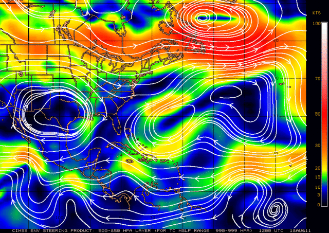
For GCANE and KWT, and anyone else who's interested, here's the steering charts for weak systems. The first chart is for 1000 to 1010 mb and the second for 990-1000 mb. KWT, I can see why you think it might turn westward again after it moves north of Honduras. Will have to watch how this steering morphs today and tonight. But the thing that should stand out is how the strength of the steering winds drops off rapidly from 20 knots to less than 10 knots over a very short distance around 83 degrees west. That implies this could slow down significantly tonight.

0 likes

Re: ATL : INVEST 93L - Discussion
somethingfunny wrote:93L has alot of pep, to use an unscientific word. I'm inclined to think it will ramp up very quickly once it forms an LLC... probably make landfall as a 60kt, 989mb tropical storm just to irritate those of us in the audience. Looks dangerous, though.
Ha yep thats true isn't it!
Suspect its very close to a TD now, lets see what recon shows...
0 likes
Personal Forecast Disclaimer:
The posts in this forum are NOT official forecast and should not be used as such. They are just the opinion of the poster and may or may not be backed by sound meteorological data. They are NOT endorsed by any professional institution or storm2k.org. For official information, please refer to the NHC and NWS products
The posts in this forum are NOT official forecast and should not be used as such. They are just the opinion of the poster and may or may not be backed by sound meteorological data. They are NOT endorsed by any professional institution or storm2k.org. For official information, please refer to the NHC and NWS products
I'll take this on for now:
000
URNT15 KNHC 181509
AF300 02FFA INVEST HDOB 08 20110818
145930 1635N 06840W 3927 07729 0419 -185 -223 360009 010 /// /// 03
150000 1634N 06843W 3926 07738 0418 -185 -213 358011 012 /// /// 03
150030 1634N 06845W 3926 07732 0419 -185 -215 355010 010 /// /// 03
150100 1633N 06848W 3926 07730 0418 -185 -213 356011 011 /// /// 03
150130 1632N 06851W 3926 07735 0419 -185 -219 356011 011 /// /// 03
150200 1631N 06854W 3926 07734 0419 -186 -210 011009 009 /// /// 03
150230 1631N 06856W 3926 07734 0419 -185 -202 013009 010 /// /// 03
150300 1630N 06859W 3926 07729 0420 -184 -208 028009 010 /// /// 03
150330 1629N 06902W 3926 07740 0420 -185 -201 027009 010 /// /// 03
150400 1628N 06905W 3926 07732 0418 -185 -206 016012 013 /// /// 03
150430 1628N 06907W 3925 07735 0419 -185 -211 008013 013 /// /// 03
150500 1627N 06910W 3927 07728 0419 -185 -207 017011 011 /// /// 03
150530 1626N 06913W 3926 07735 0418 -185 -196 012012 012 /// /// 03
150600 1625N 06916W 3927 07731 0419 -185 -191 023010 011 /// /// 03
150630 1625N 06918W 3926 07737 0418 -185 -196 038008 010 /// /// 03
150700 1624N 06921W 3925 07736 0419 -186 -193 032003 004 /// /// 03
150730 1623N 06924W 3927 07733 0418 -182 -204 029002 002 /// /// 03
150800 1622N 06927W 3926 07735 0418 -184 -197 344004 006 /// /// 03
150830 1622N 06929W 3926 07729 0418 -185 -198 001006 007 /// /// 03
150900 1621N 06932W 3927 07733 0418 -187 -204 015006 007 /// /// 03
$$
;
0 likes
Personal Forecast Disclaimer:
The posts in this forum are NOT official forecast and should not be used as such. They are just the opinion of the poster and may or may not be backed by sound meteorological data. They are NOT endorsed by any professional institution or storm2k.org. For official information, please refer to the NHC and NWS products
The posts in this forum are NOT official forecast and should not be used as such. They are just the opinion of the poster and may or may not be backed by sound meteorological data. They are NOT endorsed by any professional institution or storm2k.org. For official information, please refer to the NHC and NWS products


Re: ATL : INVEST 93L - Discussion
ozonepete wrote::uarrow: You can pretty much bet this will be named by 5PM or 11PM later today, IMHO.
As far as 8/0/0, a lot of us here are very intense storm watchers and really love to see big hurricanes so we can analyze them and learn more, 8/0/0 is disappointing on that level. But please remember none of us ever want to see them hit populated areas and hurt people. That's why we like "fish" storms that stay out in the open waters. That's a win for everybody.
The posts in this forum are NOT official forecast and should not be used as such. They are just the opinion of the poster and may or may not be backed by sound meteorological data. They are NOT endorsed by any professional institution or storm2k.org. For official information, please refer to the NHC and NWS products.
Thanks again for the reply, fishes are the best way to go indeed. Too bad the next 2 storms up don't look to be fishes and one of them is about to strengthen quick perhaps and hit land tomorrow or Sat. For a while now I've been keeping tabs on the time frame from August 15th-19th favoring hurricane events and perhaps a disaster resulting and not much had happened as of yet, but now that I saw 93L, I am now believing that today (18th) and tomorrow the 19th we could see a bombing out of the storm as it nears land. This means to me that the storm could become dangerous if it keeps doing what it's been doing the last 24 hours. I'd go more with a Friday Afternoon landfall. we'll see how it pans out, my honest opinion would be that CA should prepare for the system should it strengthen fast.
The posts in this forum are NOT official forecast and should not be used as such. They are just the opinion of the poster and may or may not be backed by sound meteorological data. They are NOT endorsed by any professional institution or storm2k.org. For official information, please refer to the NHC and NWS products.
0 likes
Georges '98, Irene '99, Frances '04, Jeanne '04, Katrina '05, Wilma '05, Gustav '08, Isaac '12, Matthew '16, Florence '18, Michael '18, Ian '22
-
Aric Dunn
- Category 5

- Posts: 21238
- Age: 43
- Joined: Sun Sep 19, 2004 9:58 pm
- Location: Ready for the Chase.
- Contact:
It for sure has a closed circ. and the mid level circ seems mostly stacked. the last couple hours you can see the ball of convection; although small, beginning to rotate with the LLC. Low shear and should pass just north of Honduras. Could approach hurricane strength especially being that its small and can intensify quickly once the convection wraps around.
0 likes
Note: If I make a post that is brief. Please refer back to previous posts for the analysis or reasoning. I do not re-write/qoute what my initial post said each time.
If there is nothing before... then just ask
Space & Atmospheric Physicist, Embry-Riddle Aeronautical University,
I believe the sky is falling...
If there is nothing before... then just ask
Space & Atmospheric Physicist, Embry-Riddle Aeronautical University,
I believe the sky is falling...

Re: ATL : INVEST 93L - Discussion
Does anyone know when recon will leave for the system?
0 likes
"People might not get all they work for in this world, but they must certainly work for all they get."- Frederick Douglass
-
HURAKAN

- Professional-Met
- Posts: 46084
- Age: 39
- Joined: Thu May 20, 2004 4:34 pm
- Location: Key West, FL
- Contact:
Re: ATL : INVEST 93L - Discussion
AHS2011 wrote:Does anyone know when recon will leave for the system?
On its way
0 likes
-
SouthDadeFish

- Professional-Met
- Posts: 2835
- Joined: Thu Sep 23, 2010 2:54 pm
- Location: Miami, FL
- Contact:

-
ozonepete
- Professional-Met
- Posts: 4743
- Joined: Mon Sep 07, 2009 3:23 pm
- Location: From Ozone Park, NYC / Now in Brooklyn, NY
Re:
Aric Dunn wrote:It for sure has a closed circ. and the mid level circ seems mostly stacked. the last couple hours you can see the ball of convection; although small, beginning to rotate with the LLC. Low shear and should pass just north of Honduras. Could approach hurricane strength especially being that its small and can intensify quickly once the convection wraps around.
I agree with everything you said.
And also the slower forward speed will allow for more intensification.
Last edited by ozonepete on Thu Aug 18, 2011 11:05 am, edited 1 time in total.
0 likes
000
URNT15 KNHC 181559
AF300 02FFA INVEST HDOB 13 20110818
154930 1506N 07309W 3929 07730 0418 -175 -279 044008 008 /// /// 03
155000 1505N 07311W 3926 07734 0420 -175 -283 042009 009 /// /// 03
155030 1504N 07314W 3922 07743 0420 -175 -266 041010 010 /// /// 03
155100 1504N 07317W 3930 07724 0420 -175 -274 040010 010 /// /// 03
155130 1504N 07320W 3926 07734 0419 -175 -290 051010 010 /// /// 03
155200 1504N 07323W 3926 07730 0418 -175 -303 057010 010 /// /// 03
155230 1504N 07326W 3927 07732 0417 -175 -304 055009 010 /// /// 03
155300 1504N 07329W 3927 07734 0418 -175 -302 052010 010 /// /// 03
155330 1504N 07331W 3926 07737 0419 -173 -304 055009 010 /// /// 03
155400 1504N 07334W 3925 07733 0419 -174 -317 064010 010 /// /// 03
155430 1504N 07337W 3926 07732 0419 -171 -328 059011 011 /// /// 03
155500 1504N 07340W 3926 07736 0419 -171 -317 061011 011 /// /// 03
155530 1504N 07343W 3925 07740 0420 -172 -307 059011 012 /// /// 03
155600 1504N 07346W 3926 07732 0419 -170 -308 063011 012 /// /// 03
155630 1504N 07349W 3926 07731 0419 -170 -297 060012 013 /// /// 03
155700 1503N 07352W 3926 07738 0419 -170 -285 063012 012 /// /// 03
155730 1503N 07354W 3927 07731 0419 -170 -284 070012 012 /// /// 03
155800 1503N 07357W 3926 07732 0419 -170 -299 068011 012 /// /// 03
155830 1503N 07400W 3926 07734 0419 -170 -292 069011 011 /// /// 03
155900 1503N 07403W 3926 07730 0418 -170 -280 071012 012 /// /// 03
$$
;
0 likes
Personal Forecast Disclaimer:
The posts in this forum are NOT official forecast and should not be used as such. They are just the opinion of the poster and may or may not be backed by sound meteorological data. They are NOT endorsed by any professional institution or storm2k.org. For official information, please refer to the NHC and NWS products
The posts in this forum are NOT official forecast and should not be used as such. They are just the opinion of the poster and may or may not be backed by sound meteorological data. They are NOT endorsed by any professional institution or storm2k.org. For official information, please refer to the NHC and NWS products
-
SouthDadeFish
- Professional-Met
- Posts: 2835
- Joined: Thu Sep 23, 2010 2:54 pm
- Location: Miami, FL
- Contact:
-
wxman57

- Moderator-Pro Met

- Posts: 23173
- Age: 68
- Joined: Sat Jun 21, 2003 8:06 pm
- Location: Houston, TX (southwest)
Re: ATL : INVEST 93L - Discussion
We're not sure (here at the office) that 93L has an LLC this morning. My coworker says he thinks he can see something south of the convection around 15N, but I can't really see anything significant there. I can't really tell if it has any LLC at all. Could just be a wave axis with a blob of squalls near the northern part of the wave. We do agree that it has a better-than-not chance of becoming "Harvey" before it moves inland, though. So don't be surprised if recon gets there in the next hour and doesn't find anything in the way of an LLC.
0 likes
-
Ivanhater

- Storm2k Moderator

- Posts: 11221
- Age: 39
- Joined: Fri Jul 01, 2005 8:25 am
- Location: Pensacola
Re: ATL : INVEST 93L - Discussion
wxman57 wrote:We're not sure (here at the office) that 93L has an LLC this morning. My coworker says he thinks he can see something south of the convection around 15N, but I can't really see anything significant there. I can't really tell if it has any LLC at all. Could just be a wave axis with a blob of squalls near the northern part of the wave. We do agree that it has a better-than-not chance of becoming "Harvey" before it moves inland, though. So don't be surprised if recon gets there in the next hour and doesn't find anything in the way of an LLC.
Microwave seems to suggest a LLC under the convection

0 likes
Michael
Will be interesting Wxman57, that has been the trend of the season when it comes to strongly organised mid levels but poorly defined lower levels.
0 likes
Personal Forecast Disclaimer:
The posts in this forum are NOT official forecast and should not be used as such. They are just the opinion of the poster and may or may not be backed by sound meteorological data. They are NOT endorsed by any professional institution or storm2k.org. For official information, please refer to the NHC and NWS products
The posts in this forum are NOT official forecast and should not be used as such. They are just the opinion of the poster and may or may not be backed by sound meteorological data. They are NOT endorsed by any professional institution or storm2k.org. For official information, please refer to the NHC and NWS products
-
wxman57
- Moderator-Pro Met
- Posts: 23173
- Age: 68
- Joined: Sat Jun 21, 2003 8:06 pm
- Location: Houston, TX (southwest)
Re: ATL : INVEST 93L - Discussion
Ivanhater wrote:wxman57 wrote:We're not sure (here at the office) that 93L has an LLC this morning. My coworker says he thinks he can see something south of the convection around 15N, but I can't really see anything significant there. I can't really tell if it has any LLC at all. Could just be a wave axis with a blob of squalls near the northern part of the wave. We do agree that it has a better-than-not chance of becoming "Harvey" before it moves inland, though. So don't be surprised if recon gets there in the next hour and doesn't find anything in the way of an LLC.
Microwave seems to suggest a LLC under the convection
http://i52.tinypic.com/33k62py.jpg
I think it's suggestive of some rotation, which we can clearly see on satellite loops. But I'm not sure that rotation is actually at the surface yet or whether it's 1000-2000 feet up where the low cloud bases are.
0 likes
000
URNT15 KNHC 181609
AF300 02FFA INVEST HDOB 14 20110818
155930 1503N 07406W 3925 07735 0418 -170 -284 072012 012 /// /// 03
160000 1503N 07409W 3926 07738 0418 -171 -293 073012 013 /// /// 03
160030 1503N 07412W 3922 07737 0419 -175 -305 077011 012 /// /// 03
160100 1503N 07415W 3930 07721 0417 -170 -321 070013 013 /// /// 03
160130 1503N 07418W 3927 07736 0417 -170 -313 071012 013 /// /// 03
160200 1503N 07421W 3926 07733 0419 -170 -295 073012 012 /// /// 03
160230 1503N 07423W 3926 07736 0418 -170 -293 075013 013 /// /// 03
160300 1503N 07426W 3926 07728 0418 -170 -299 076012 013 /// /// 03
160330 1502N 07429W 3927 07730 0418 -170 -307 068013 013 /// /// 03
160400 1502N 07432W 3925 07732 0418 -170 -296 070013 013 /// /// 03
160430 1502N 07435W 3926 07734 0418 -170 -290 070013 013 /// /// 03
160500 1502N 07438W 3926 07733 0416 -170 -288 068014 014 /// /// 03
160530 1502N 07441W 3926 07733 0419 -170 -288 067014 014 /// /// 03
160600 1502N 07444W 3925 07737 0418 -169 -295 066013 014 /// /// 03
160630 1502N 07447W 3927 07729 0418 -169 -310 070014 014 /// /// 03
160700 1502N 07450W 3926 07729 0416 -165 -319 064013 014 /// /// 03
160730 1502N 07453W 3926 07731 0417 -165 -321 068014 014 /// /// 03
160800 1502N 07455W 3926 07730 0417 -165 -319 070014 015 /// /// 03
160830 1502N 07458W 3926 07733 0417 -165 -323 064014 014 /// /// 03
160900 1502N 07501W 3926 07734 0417 -165 -314 066014 014 /// /// 03
$$
;
0 likes
Personal Forecast Disclaimer:
The posts in this forum are NOT official forecast and should not be used as such. They are just the opinion of the poster and may or may not be backed by sound meteorological data. They are NOT endorsed by any professional institution or storm2k.org. For official information, please refer to the NHC and NWS products
The posts in this forum are NOT official forecast and should not be used as such. They are just the opinion of the poster and may or may not be backed by sound meteorological data. They are NOT endorsed by any professional institution or storm2k.org. For official information, please refer to the NHC and NWS products
-
ozonepete
- Professional-Met
- Posts: 4743
- Joined: Mon Sep 07, 2009 3:23 pm
- Location: From Ozone Park, NYC / Now in Brooklyn, NY
Re: ATL : INVEST 93L - Discussion
Ivanhater wrote:Microwave seems to suggest a LLC under the convection
http://i52.tinypic.com/33k62py.jpg
Smart post, Michael. That's the only way to get an idea if there's an LLC under obscuring convection. I agree it suggests an LLC is there under that ball of convection.
0 likes
-
ozonepete
- Professional-Met
- Posts: 4743
- Joined: Mon Sep 07, 2009 3:23 pm
- Location: From Ozone Park, NYC / Now in Brooklyn, NY
Re: ATL : INVEST 93L - Discussion
0 likes
Who is online
Users browsing this forum: No registered users and 132 guests