ATL: IRENE - Remnants - Discussion

Moderator: S2k Moderators

Message
Author
User avatar
KWT
Category 5
Category 5
Posts: 31415
Joined: Tue Aug 17, 2004 11:02 am
Location: UK!!!

Re:

#121 Postby KWT » Thu Aug 18, 2011 11:58 am

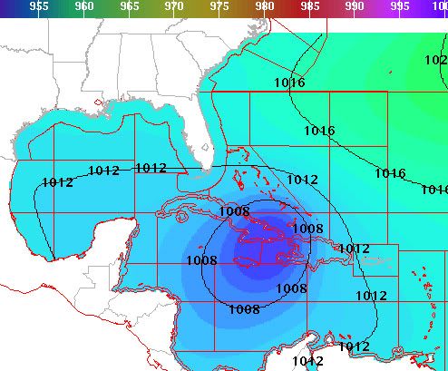
AdamFirst wrote:I haven't seen the hype machine crank up so readily for an invest like this.

Why the special attention?


Because the models (espeically the GFS) has been both agressive and consistant with it...

I also think its partly because this is the first real geniune threat to the US as well this season.
0 likes   
Personal Forecast Disclaimer:
The posts in this forum are NOT official forecast and should not be used as such. They are just the opinion of the poster and may or may not be backed by sound meteorological data. They are NOT endorsed by any professional institution or storm2k.org. For official information, please refer to the NHC and NWS products

User avatar
cycloneye
Admin
Admin
Posts: 145270
Age: 68
Joined: Thu Oct 10, 2002 10:54 am
Location: San Juan, Puerto Rico

Re: ATL: INVEST 97L - Discussion

#122 Postby cycloneye » Thu Aug 18, 2011 12:35 pm

2 PM TWO:

A LARGE TROPICAL WAVE LOCATED NEARLY MIDWAY BETWEEN THE CAPE VERDE
ISLANDS AND THE LESSER ANTILLES CONTINUES TO PRODUCE LIMITED SHOWER
ACTIVITY. SIGNIFICANT DEVELOPMENT IS NOT LIKELY DURING THE NEXT
COUPLE OF DAYS. HOWEVER...ENVIRONMENTAL CONDITIONS COULD BECOME
MORE CONDUCIVE FOR DEVELOPMENT AFTER THAT TIME. THIS SYSTEM HAS A
LOW CHANCE...10 PERCENT...OF BECOMING A TROPICAL CYCLONE DURING THE
NEXT 48 HOURS AS IT MOVES WESTWARD AT 15 MPH.
0 likes   
Visit the Caribbean-Central America Weather Thread where you can find at first post web cams,radars
and observations from Caribbean basin members Click Here

Aric Dunn
Category 5
Category 5
Posts: 21238
Age: 42
Joined: Sun Sep 19, 2004 9:58 pm
Location: Ready for the Chase.
Contact:

#123 Postby Aric Dunn » Thu Aug 18, 2011 12:36 pm

Well on a side note.. the FNMOC has finally decided to develop it.. lol
0 likes   
Note: If I make a post that is brief. Please refer back to previous posts for the analysis or reasoning. I do not re-write/qoute what my initial post said each time.
If there is nothing before... then just ask :)

Space & Atmospheric Physicist, Embry-Riddle Aeronautical University,
I believe the sky is falling...

User avatar
KWT
Category 5
Category 5
Posts: 31415
Joined: Tue Aug 17, 2004 11:02 am
Location: UK!!!

#124 Postby KWT » Thu Aug 18, 2011 12:49 pm

Well more or less the same idea from the NHC Cycloneye which sounds reasonable, not much chance before 48hrs is up, but chances increase from then on, esp past 72hrs.
0 likes   
Personal Forecast Disclaimer:
The posts in this forum are NOT official forecast and should not be used as such. They are just the opinion of the poster and may or may not be backed by sound meteorological data. They are NOT endorsed by any professional institution or storm2k.org. For official information, please refer to the NHC and NWS products

User avatar
HurricaneMaster_PR
Category 2
Category 2
Posts: 795
Joined: Tue Jul 22, 2003 6:23 pm
Location: San Juan, Puerto Rico

Re: ATL: INVEST 97L - Discussion

#125 Postby HurricaneMaster_PR » Thu Aug 18, 2011 12:52 pm

Latest TAFB Surface Forecast (72 hrs)
Image
0 likes   

User avatar
KWT
Category 5
Category 5
Posts: 31415
Joined: Tue Aug 17, 2004 11:02 am
Location: UK!!!

#126 Postby KWT » Thu Aug 18, 2011 12:54 pm

Interesting track, that forecast takes it a touch WSW into PR and towards Hispaniola.

Track first 72hrs looks like 00z ECM...
0 likes   
Personal Forecast Disclaimer:
The posts in this forum are NOT official forecast and should not be used as such. They are just the opinion of the poster and may or may not be backed by sound meteorological data. They are NOT endorsed by any professional institution or storm2k.org. For official information, please refer to the NHC and NWS products

User avatar
northjaxpro
S2K Supporter
S2K Supporter
Posts: 8900
Joined: Mon Sep 27, 2010 11:21 am
Location: Jacksonville, FL

Re:

#127 Postby northjaxpro » Thu Aug 18, 2011 1:01 pm

KWT wrote:Interesting track, that forecast takes it a touch WSW into PR and towards Hispaniola.

Track first 72hrs looks like 00z ECM...


This may very well be a situation where 50-100 miles deviation in track could make all the difference in terms of a potentially strengthening tropical cyclone or one that interacts with the islands. This is going to be interesting to monitor in a few days to see how this shakes down.
0 likes   
NEVER, EVER SAY NEVER in the tropics and weather in general, and most importantly, with life itself!!

________________________________________________________________________________________

Fay 2008 Beryl 2012 Debby 2012 Colin 2016 Hermine 2016 Julia 2016 Matthew 2016 Irma 2017 Dorian 2019

User avatar
HurricaneMaster_PR
Category 2
Category 2
Posts: 795
Joined: Tue Jul 22, 2003 6:23 pm
Location: San Juan, Puerto Rico

Re: ATL: INVEST 97L - Discussion

#128 Postby HurricaneMaster_PR » Thu Aug 18, 2011 1:30 pm

DATE/TIME LAT LON CLASSIFICATION STORM
18/1745 UTC 12.9N 40.1W TOO WEAK 97L
0 likes   

Aric Dunn
Category 5
Category 5
Posts: 21238
Age: 42
Joined: Sun Sep 19, 2004 9:58 pm
Location: Ready for the Chase.
Contact:

#129 Postby Aric Dunn » Thu Aug 18, 2011 1:32 pm

Did it get classified as an invest early enough for the 12z runs of the hurricane models.. ?
0 likes   
Note: If I make a post that is brief. Please refer back to previous posts for the analysis or reasoning. I do not re-write/qoute what my initial post said each time.
If there is nothing before... then just ask :)

Space & Atmospheric Physicist, Embry-Riddle Aeronautical University,
I believe the sky is falling...

User avatar
northtxboy
Category 1
Category 1
Posts: 262
Age: 43
Joined: Mon Jan 03, 2011 1:50 pm
Location: Windom Tx
Contact:

#130 Postby northtxboy » Thu Aug 18, 2011 1:39 pm

Look at all the people online now!!! This might get alittle crazy :eek:
0 likes   

weatherguy2
Tropical Depression
Tropical Depression
Posts: 72
Joined: Sun Aug 01, 2010 2:45 am

Re: ATL: INVEST 97L - Discussion

#131 Postby weatherguy2 » Thu Aug 18, 2011 1:50 pm

New NHC grid forecast for the morning of AUG 24th, it's at the south tip of Cuba:
Image
0 likes   

User avatar
cycloneye
Admin
Admin
Posts: 145270
Age: 68
Joined: Thu Oct 10, 2002 10:54 am
Location: San Juan, Puerto Rico

Re: ATL: INVEST 97L - Discussion

#132 Postby cycloneye » Thu Aug 18, 2011 1:57 pm

18z Best Track

AL, 97, 2011081818, , BEST, 0, 136N, 394W, 25, 1008, DB
0 likes   
Visit the Caribbean-Central America Weather Thread where you can find at first post web cams,radars
and observations from Caribbean basin members Click Here

User avatar
KWT
Category 5
Category 5
Posts: 31415
Joined: Tue Aug 17, 2004 11:02 am
Location: UK!!!

#133 Postby KWT » Thu Aug 18, 2011 2:22 pm

Looks like its over Cuba to me weatherguy2. Would be a hard call to find out where it goes from there, either westwards into the Caribbean or into the Bahamas region.
0 likes   
Personal Forecast Disclaimer:
The posts in this forum are NOT official forecast and should not be used as such. They are just the opinion of the poster and may or may not be backed by sound meteorological data. They are NOT endorsed by any professional institution or storm2k.org. For official information, please refer to the NHC and NWS products

User avatar
Vortex
S2K Supporter
S2K Supporter
Posts: 4644
Age: 53
Joined: Fri Aug 01, 2003 9:34 pm
Location: Hilton Head, SC

#134 Postby Vortex » Thu Aug 18, 2011 2:34 pm

NWS Miami afternoon update:

Rarely do they mention anyting 7 days out...Consevative at best. Obviouly, they see what we see..


Snipet:

EXTENDED PERIOD...SUNDAY THROUGH THURSDAY...SLIGHTLY DRIER AIR WILL
MOVE OVER S FLA THROUGH MIDWEEK WITH CLIMO POPS. NOCTURNAL E COAST
AND DIURNAL INTERIOR AND W CONVECTION EXPECTED. THE LONG RANGE MODELS
LINING UP AND AGREEING THAT A DEVELOPING TROPICAL WAVE APPROACHES
THE AREA LATE NEXT WEEK. AT THIS TIME...LOADING ECMWF WINDS AND
LEAVING WEATHER AS IS PENDING ADDITIONAL GUIDANCE/DEVELOPMENT.
0 likes   

HUC
Category 2
Category 2
Posts: 590
Joined: Fri Oct 03, 2003 3:48 pm
Location: Basse-Terre Guadeloupe

#135 Postby HUC » Thu Aug 18, 2011 2:35 pm

I should said the real center appears to organised around 12N - 40,5Wwhere a small cluster just begining...Let's see
0 likes   

HUC
Category 2
Category 2
Posts: 590
Joined: Fri Oct 03, 2003 3:48 pm
Location: Basse-Terre Guadeloupe

#136 Postby HUC » Thu Aug 18, 2011 2:38 pm

0 likes   

User avatar
Hurricaneman
Category 5
Category 5
Posts: 7350
Age: 45
Joined: Tue Aug 31, 2004 3:24 pm
Location: central florida

Re: ATL: INVEST 97L - Discussion

#137 Postby Hurricaneman » Thu Aug 18, 2011 2:40 pm

I see the possible center at 14.1n 38.2w

The posts in this forum are NOT official forecast and should not be used as such. They are just the opinion of the poster and may or may not be backed by sound meteorological data. They are NOT endorsed by any professional institution or storm2k.org. For official information, please refer to the NHC and NWS products
0 likes   

User avatar
wxman57
Moderator-Pro Met
Moderator-Pro Met
Posts: 22976
Age: 67
Joined: Sat Jun 21, 2003 8:06 pm
Location: Houston, TX (southwest)

Re: ATL: INVEST 97L - Discussion

#138 Postby wxman57 » Thu Aug 18, 2011 2:43 pm

Look farther west - 14N/41.3W.
0 likes   

User avatar
Vortex
S2K Supporter
S2K Supporter
Posts: 4644
Age: 53
Joined: Fri Aug 01, 2003 9:34 pm
Location: Hilton Head, SC

#139 Postby Vortex » Thu Aug 18, 2011 2:43 pm

Buoy not to far from estimated center...

14.9/38W

Air Temperature (ATMP): 81.0 °F
Water Temperature (WTMP): 80.6 °F
Atmospheric Pressure (PRES): 29.81 in
Wind Speed (WSPD): 13.0 kts
Wind Direction (WDIR): E (100 deg)
0 likes   

HurricaneWarning92
Category 2
Category 2
Posts: 520
Joined: Sat Jul 23, 2011 4:33 pm
Location: Pembroke Pines, S. Florida (Lat: 26.00N, Lon: 80.22W)

#140 Postby HurricaneWarning92 » Thu Aug 18, 2011 2:43 pm

yep i see it there too...
0 likes   
The posts in this forum are NOT official forecast and should not be used as such. They are just the opinion of the poster and may or may not be backed by sound meteorological data. They are NOT endorsed by any professional institution or storm2k.org. For official information, please refer to the NHC and NWS products.


Return to “2011”

Who is online

Users browsing this forum: No registered users and 26 guests