ATL: NATE - Remnants - Discussion
Moderator: S2k Moderators
Re: ATL: NATE - Models
Looks like the CMC has only slightly shifted its outlier solution. Just off the Louisiana/Mississippi coast at 96h.
0 likes

Re: ATL: NATE - Models
need to see the CMC tonight and see if that flips as well....all the globals showing the same thing would pretty much put the last nail in the coffin...damn Nate...what kind of name is that anyway.... 
0 likes
-
Rgv20

- S2K Supporter

- Posts: 2466
- Age: 39
- Joined: Wed Jan 05, 2011 5:42 pm
- Location: Edinburg/McAllen Tx
Re: ATL: NATE - Models
clfenwi wrote:Looks like the CMC has only slightly shifted its outlier solution. Just off the Louisiana/Mississippi coast at 96h.
Just looked at it, but IMO its way way to fast with regards to Nate's track.
0 likes
The following post is NOT an official forecast and should not be used as such. It is just the opinion of the poster and may or may not be backed by sound meteorological data. It is NOT endorsed by any professional institution including storm2k.org For Official Information please refer to the NHC and NWS products.
-
Wx_Warrior
- Category 5

- Posts: 2718
- Joined: Thu Aug 03, 2006 3:58 pm
- Location: Beaumont, TX
Re: ATL: NATE - Models
clfenwi wrote:Looks like the CMC has only slightly shifted its outlier solution. Just off the Louisiana/Mississippi coast at 96h.
lost me link to the CMC...anyone care to share?
0 likes
Re: ATL: NATE - Models
Wx_Warrior wrote:CMC back to it's old self. NICE.
now if the EURO shifts you will be singing a different tune....
0 likes
-
Rgv20
- S2K Supporter
- Posts: 2466
- Age: 39
- Joined: Wed Jan 05, 2011 5:42 pm
- Location: Edinburg/McAllen Tx
Re: ATL: NATE - Models
ROCK wrote:clfenwi wrote:Looks like the CMC has only slightly shifted its outlier solution. Just off the Louisiana/Mississippi coast at 96h.
lost me link to the CMC...anyone care to share?
Here you go Rock....http://www.weatheroffice.gc.ca/model_forecast/global_e.html
Just a tip the Black and White Charts update faster than the Color ones..
0 likes
The following post is NOT an official forecast and should not be used as such. It is just the opinion of the poster and may or may not be backed by sound meteorological data. It is NOT endorsed by any professional institution including storm2k.org For Official Information please refer to the NHC and NWS products.
-
Wx_Warrior
- Category 5
- Posts: 2718
- Joined: Thu Aug 03, 2006 3:58 pm
- Location: Beaumont, TX
Re: ATL: NATE - Models
0 likes
Re: ATL: NATE - Models
http://www.weatheroffice.gc.ca/model_forecast/global_e.html for the source.
Loop will be on http://moe.met.fsu.edu/tcgengifs/ shortly.
And I'll revise my statement. Not any shift in landfall position... just ~12 hr slower in timing compared to the 12Z run... if I didn't know better, I would think I was looking at an interpolated run.
Loop will be on http://moe.met.fsu.edu/tcgengifs/ shortly.
And I'll revise my statement. Not any shift in landfall position... just ~12 hr slower in timing compared to the 12Z run... if I didn't know better, I would think I was looking at an interpolated run.
Last edited by clfenwi on Thu Sep 08, 2011 12:04 am, edited 1 time in total.
0 likes
-
Wx_Warrior
- Category 5
- Posts: 2718
- Joined: Thu Aug 03, 2006 3:58 pm
- Location: Beaumont, TX
-
Huckster

- Category 1

- Posts: 394
- Age: 44
- Joined: Fri Aug 13, 2004 2:33 am
- Location: Baton Rouge, LA
- Contact:
Re: ATL: NATE - Models
Ixolib wrote:Radiogirltx wrote:LaBreeze wrote:Just curious - what areas are considered NE GOM, Central (North) GOM, and NW GOM? Is there a particular dividing line that most people use on here? I was just wondering - thanks in advance.
I'd like to know too. I posed the same question during the Irene thread, but never noticed a response.
My opinion would be:
NE GOM = Pensacola to Big Bend
EASTERN GOM = Big Bend southward to Key West
CENTRAL GOM = Mississippi and Louisiana
NW GOM = Sabine Pass to Matagorda Bay (maybe Corpus???)
WESTERN GOM = Matagorda Bay southward to Brownsville
SW GOM = Brownsville southward to Veracruz
I suppose one could also use the NHC breakpoints as a point of reference...
http://www.nhc.noaa.gov/breakpoints/images/bp_gulf_11.jpg
Of course, we all know what they say about opinions...
I've been wondering and confused about what part of the Gulf is what. I've confused myself; do I live on the North Gulf Coast? or West? or Central? or North-central? Does the Gulf even exist
 So, I took a map, and made some boxes, lines, and a circle. Please feel free to give constructive criticism. Every day we live, we learn something new. The only way to get an answer is to ask a question.
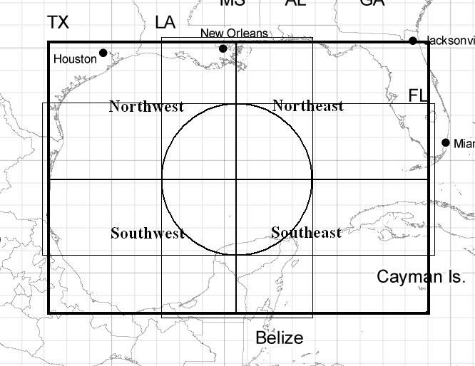
0 likes
Re: ATL: NATE - Models
I dont think it is intialized right from the get go....has it farther up the Yuc....interesting...
0 likes
-
Rgv20
- S2K Supporter
- Posts: 2466
- Age: 39
- Joined: Wed Jan 05, 2011 5:42 pm
- Location: Edinburg/McAllen Tx
Re: ATL: NATE - Models
Wx_Warrior wrote:Need 2-3 consecutive runs for me to jump.
I'm still not sold on Nate being a threat to the Northern Gulf but I still need one more run of the ECMWF to be sure..
Oh and the NHC agrees with me so Im pretty confident......or do I agree with the NHC?
0 likes
The following post is NOT an official forecast and should not be used as such. It is just the opinion of the poster and may or may not be backed by sound meteorological data. It is NOT endorsed by any professional institution including storm2k.org For Official Information please refer to the NHC and NWS products.

What about the cooler temps(with the dryer air) we have been experiencing here in SE LA? Would that tend to lessen development or direction into the gulf states?
edit: I see a comment I missed about the dry air above(Macrocane). Same thing for cooler temp?
edit: I see a comment I missed about the dry air above(Macrocane). Same thing for cooler temp?
Macrocane wrote:The posts in this forum are NOT official forecast and should not be used as such. They are just the opinion of the poster and may or may not be backed by sound meteorological data. They are NOT endorsed by any professional institution or storm2k.org. For official information, please refer to the NHC and NWS products.
If shear is going to weaken and remain low then the dry air won't be a big problem for Nate, it may slow strengthening a little but not weaken the cyclone, I believe it will make it to hurricane status as it will have enough time to strengthen once the baroclinic processes in the area end. D-max should help Nate in its organization process tonight.
0 likes

Re:
bayoubebe wrote:What about the cooler temps(with the dryer air) we have been experiencing here in SE LA? Would that tend to lessen development or direction into the gulf states?
edit: I see a comment I missed about the dry air above(Macrocane). Same thing for cooler temp?
I don't think the cooler temps will have any effect on Nate because this is just the first cool shot in a looong time and sea cools slower than land so the SST will stay the same, anyway it is expected to stay south enough from most of the Gulf states.
0 likes
-
TwisterFanatic

- Category 5
- Posts: 1041
- Joined: Mon Jun 28, 2010 12:43 pm
- Location: Sallisaw, Oklahoma
EURO has a monster high push it SW from 96-120 HRS. It was headed towards the South Texas coast and BAM!
http://raleighwx.americanwx.com/models/ ... _loop.html
http://raleighwx.americanwx.com/models/ ... _loop.html
0 likes
Personal Forecast Disclaimer:
The posts in this forum are NOT official forecast and should not be used as such. They are just the opinion of the poster and may or may not be backed by sound meteorological data. They are NOT endorsed by any professional institution or storm2k.org. For official information, please refer to the NHC and NWS products.
The posts in this forum are NOT official forecast and should not be used as such. They are just the opinion of the poster and may or may not be backed by sound meteorological data. They are NOT endorsed by any professional institution or storm2k.org. For official information, please refer to the NHC and NWS products.

Re: ATL: NATE - Models
Big Time changes with 06z GFS - tropical cyclone into Gulfport Miss then sliding east along coast to P'Cola.
06z GFS
06z GFS
0 likes

Re: ATL: NATE - Models
WOW! Looks like the operational is now coming more in line with the ensembles. Interesting days ahead.
0 likes
Re: ATL: NATE - Tropical Storm - Discussion
Check out the 6Z GFS on the models forum...HUGE shift! Now has landfall around Mississippi on Tuesday as a strong looking cyclone, then moving east towards Florida Panhandle.
0 likes
-
Sabanic

- Category 2

- Posts: 683
- Age: 66
- Joined: Wed Aug 01, 2007 7:01 am
- Location: Mobile, AL
- Contact:
Re: ATL: NATE - Models
ronjon wrote:Big Time changes with 06z GFS - tropical cyclone into Gulfport Miss then sliding east along coast to P'Cola.
06z GFS
Now that would be nasty!!
0 likes
"I can do all things through Christ which strengtheneth me" - Philippians 4:13
Who is online
Users browsing this forum: No registered users and 27 guests