Is there already someone for the Maria obs?
If not, I could post 'em for a few hours.
ATL: MARIA - Post-Tropical - Discussion
Moderator: S2k Moderators
-
Extratropical94

- Professional-Met

- Posts: 3545
- Age: 31
- Joined: Wed Oct 20, 2010 6:36 am
- Location: Hamburg, Germany
- Contact:
0 likes
54° 11' 59'' N, 9° 9' 20'' E
Boomer Sooner!
Go Broncos! Go Cards!
Clinching counties, one at a time: https://mob-rule.com/user-gifs/USA/xtrp94.gif
- Daniel
Boomer Sooner!
Go Broncos! Go Cards!
Clinching counties, one at a time: https://mob-rule.com/user-gifs/USA/xtrp94.gif
- Daniel
-
Blown Away

- S2K Supporter

- Posts: 10253
- Joined: Wed May 26, 2004 6:17 am
Re: ATL: MARIA - Recon Discussion
Did they bring a big fork on the plane?
0 likes
Hurricane Eye Experience: David 79, Irene 99, Frances 04, Jeanne 04, Wilma 05… Hurricane Brush Experience: Andrew 92, Erin 95, Floyd 99, Matthew 16, Irma 17, Ian 22, Nicole 22…
-
northjaxpro

- S2K Supporter
- Posts: 8900
- Joined: Mon Sep 27, 2010 11:21 am
- Location: Jacksonville, FL
Re:
Aric Dunn wrote:I guess for Maria... 13 is her lucky number... ( 13N that is) still riding that line..
LOL.. Yeah, Aric, she is hugging the 13 latitude for sure.
It looks as if Maria will survive not generating into a tropical wave. Convection is still building near to where the low level swirl which was displaced overnight.
0 likes
NEVER, EVER SAY NEVER in the tropics and weather in general, and most importantly, with life itself!!
________________________________________________________________________________________
Fay 2008 Beryl 2012 Debby 2012 Colin 2016 Hermine 2016 Julia 2016 Matthew 2016 Irma 2017 Dorian 2019
________________________________________________________________________________________
Fay 2008 Beryl 2012 Debby 2012 Colin 2016 Hermine 2016 Julia 2016 Matthew 2016 Irma 2017 Dorian 2019
-
Dave

- Retired Staff

- Posts: 13442
- Age: 75
- Joined: Tue Aug 01, 2006 3:57 pm
- Location: Milan Indiana
- Contact:
Re:
Extratropical94 wrote:Is there already someone for the Maria obs?
If not, I could post 'em for a few hours.
Extra go ahead and pick them up when they start if you would like. I'm on Nate now and am setup for him for the time being.
0 likes
This post is NOT AN OFFICIAL FORECAST and should not be used as such. It is just the opinion of the poster and may or may not be backed by sound meteorological data. It is NOT endorsed by any professional institution including storm2k.org. For Official Information please refer to the NHC and NWS products.
-
Dave
- Retired Staff
- Posts: 13442
- Age: 75
- Joined: Tue Aug 01, 2006 3:57 pm
- Location: Milan Indiana
- Contact:
Re: ATL: MARIA - Recon Discussion
Blown Away wrote:Did they bring a big fork on the plane?
Blown Away now you know they did...it's lunch time.
0 likes
This post is NOT AN OFFICIAL FORECAST and should not be used as such. It is just the opinion of the poster and may or may not be backed by sound meteorological data. It is NOT endorsed by any professional institution including storm2k.org. For Official Information please refer to the NHC and NWS products.
-
Gustywind

- Category 5

- Posts: 12334
- Joined: Mon Sep 03, 2007 7:29 am
- Location: Baie-Mahault, GUADELOUPE
For those who are interrested here is the latest weather forecast Guadeloupe concerning TS Maria 11am ( source Meteo-france Guadeloupe).
 http://www.meteo.fr/temps/domtom/antill ... ameter=new Date().getTime() (french version).
Bulletin of tracking No.: 4. Episode No.: 28 - GD
Thursday, September 8, 2011
11: 30 a.m.
Meteorological vigilance Guadeloupe LEVEL yellow for the tropical storm "MARIA".
Phenomenon (type, name):
TROPICAL STORM "MARIA".
Current position(distance)
At 11 A.M, the center was located at 13 ° 0 North and 51 ° 2 West, approximately 1200 km South-East of Guadeloupe.
Characteristics,current intensity of the cyclone
Estimated average maximum wind: 85 km/h gust: 100 km/h. Range, winds > 65 km/h: 185 km North.
Minimum pressure: 1005 hectoPascals.
Displacement current Direction (cap): to the West at 35 km/h
Forecasts (mouvement and (intensity)
For now, the more likely scenario is moving the center of MARIA in the vicinity of Martinica on the night of Friday to Saturday. MARIA is always expected to be at this time a moderate tropical storm. Uncertainty is always great, the trajectories for MARIA can evolve between St. Vincent and Barbuda. This scenario is therefore still led to evolve and refine by the next 36 hours. According to this forecast track and intensity, Guadeloupe should know substantial consequent stormy episodes from Friday afternoon and until Saturday evening and a gradual strengthening of the wind during the day. Average winds of the range of 60 to 80 km/h, with gusts to 100 km/h are expected during the night of Friday to Saturday. From North-Est direction, the wind wind will switch South and then southeast during the night. Concerning the sea, the first effects of the long and strong swell from East to North-East begin tomorrow morning with average waves of 2 m 50, 3 meters 50 before reach 4 to 5 meters in evening and night of Friday to Saturday.
Comments /Consequences
Risks related to stormy rain: sudden rising waters, raw, floods, landslides, lightning, gusts of wind. Dangerous sea with larges welters on exposed coasts.
Summary
Moderate risk of occurrence of the phenomenon. The expected impact is moderate to strong.
Validity -period of the phenomenon
Cyclonic effects expected on Friday 9th afternoon to Saturday 10th at night.
Next newsletter
This Thursday, September 8th at 530 PM.
0 likes
-
BatzVI

- Tropical Storm

- Posts: 199
- Joined: Sat Jun 10, 2006 8:27 am
- Location: St. Thomas, Virgin Islands
Re: ATL: MARIA- Tropical Storm- Discussion
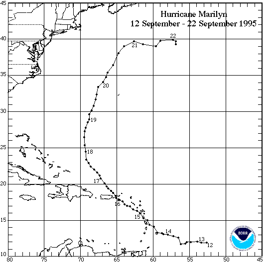
This just has shades of Marilyn '95 to me....disorganized, then passing through Guadeloupe area, slowing down, intensifying, and then slamming up from the south....hopefully she'll stay disorganized....
0 likes
-
SuperLikeNintendo
- Tropical Low

- Posts: 18
- Joined: Wed Aug 31, 2011 1:14 pm
-
Gustywind
- Category 5
- Posts: 12334
- Joined: Mon Sep 03, 2007 7:29 am
- Location: Baie-Mahault, GUADELOUPE
Re: ATL: MARIA- Tropical Storm- Discussion
BatzVI wrote:This just has shades of Marilyn '95 to me....disorganized, then passing through Guadeloupe area, slowing down, intensifying, and then slamming up from the south....hopefully she'll stay disorganized....
Not good memories for most of the Leewardians
0 likes
-
BatzVI
- Tropical Storm
- Posts: 199
- Joined: Sat Jun 10, 2006 8:27 am
- Location: St. Thomas, Virgin Islands
Re: ATL: MARIA- Tropical Storm- Discussion
Scariest night of my life in St. Thomas....stay safe Gusty...and everyone else
0 likes
-
Aric Dunn
- Category 5
- Posts: 21238
- Age: 43
- Joined: Sun Sep 19, 2004 9:58 pm
- Location: Ready for the Chase.
- Contact:
heads up.. hwrf at the 6z run had the sharp nw turn at about 55W ... well so far with the run not till up to 60 west. still heading west.
0 likes
Note: If I make a post that is brief. Please refer back to previous posts for the analysis or reasoning. I do not re-write/qoute what my initial post said each time.
If there is nothing before... then just ask
Space & Atmospheric Physicist, Embry-Riddle Aeronautical University,
I believe the sky is falling...
If there is nothing before... then just ask
Space & Atmospheric Physicist, Embry-Riddle Aeronautical University,
I believe the sky is falling...
-
HurricaneMaster_PR

- Category 2

- Posts: 795
- Joined: Tue Jul 22, 2003 6:23 pm
- Location: San Juan, Puerto Rico
Re: ATL: MARIA- Tropical Storm- Discussion
Gustywind wrote:BatzVI wrote:This just has shades of Marilyn '95 to me....disorganized, then passing through Guadeloupe area, slowing down, intensifying, and then slamming up from the south....hopefully she'll stay disorganized....
Not good memories for most of the Leewardians, especially for us in Guadeloupe tell HUC how nasty was this night at Basse-Terre.. a nightmare. Let's hope it stays like that and be on our guard islanders.
This is Marilyn (95') Track. Something similar is what is forecast to happen with Maria (in the short-medium term)
0 likes
-
Extratropical94
- Professional-Met
- Posts: 3545
- Age: 31
- Joined: Wed Oct 20, 2010 6:36 am
- Location: Hamburg, Germany
- Contact:
Recon aircraft on the ground.
Observation 01
URNT15 KNHC 081716
AF306 0114A MARIA HDOB 01 20110908
170630 1742N 06448W 0137 ///// //// //// +227 360000 000 /// /// 25
170700 1742N 06448W 0136 ///// //// //// +228 360000 000 /// /// 25
170730 1742N 06448W 0135 ///// 0124 +392 +230 360000 000 /// /// 23
170800 1742N 06448W 0137 ///// 0124 +387 +228 360000 000 /// /// 23
170830 1742N 06448W 0137 ///// 0124 +387 +229 360000 000 /// /// 23
170900 1742N 06448W 0135 ///// 0124 +380 +229 360000 000 /// /// 23
170930 1742N 06448W 0135 ///// 0124 +379 +230 360000 000 /// /// 23
171000 1742N 06448W 0135 ///// 0124 +376 +230 360000 000 /// /// 23
171030 1742N 06448W 0135 ///// 0124 +374 +232 360000 000 /// /// 23
171100 1742N 06448W 0135 ///// 0123 +380 +234 360000 000 /// /// 23
171130 1742N 06448W 0137 ///// 0124 +356 +238 360000 000 /// /// 23
171200 1742N 06447W 0136 ///// 0123 +333 +239 360000 000 /// /// 23
171230 1742N 06447W 0134 ///// 0122 +328 +235 360000 000 /// /// 23
171300 1742N 06448W 0133 ///// 0121 +318 +233 360000 000 /// /// 23
171330 1742N 06448W 0135 ///// 0122 +319 +233 360000 000 /// /// 23
171400 1742N 06448W 0134 ///// 0121 +316 +232 360000 000 /// /// 23
171430 1742N 06448W 0131 ///// 0118 +311 +230 360000 000 /// /// 23
171500 1742N 06448W 0129 ///// 0116 +302 +228 360000 000 /// /// 23
171530 1742N 06448W 0126 ///// 0114 +295 +225 360000 000 /// /// 23
171600 1742N 06449W 0123 ///// 0111 +291 +222 360000 000 /// /// 23
$$
0 likes
54° 11' 59'' N, 9° 9' 20'' E
Boomer Sooner!
Go Broncos! Go Cards!
Clinching counties, one at a time: https://mob-rule.com/user-gifs/USA/xtrp94.gif
- Daniel
Boomer Sooner!
Go Broncos! Go Cards!
Clinching counties, one at a time: https://mob-rule.com/user-gifs/USA/xtrp94.gif
- Daniel
-
cycloneye

- Admin

- Posts: 149436
- Age: 69
- Joined: Thu Oct 10, 2002 10:54 am
- Location: San Juan, Puerto Rico
Re: ATL: MARIA - Recon Discussion
Plane ready to depart from St Croix.
0 likes
Visit the Caribbean-Central America Weather Thread where you can find at first post web cams,radars
and observations from Caribbean basin members Click Here
and observations from Caribbean basin members Click Here
-
BatzVI
- Tropical Storm
- Posts: 199
- Joined: Sat Jun 10, 2006 8:27 am
- Location: St. Thomas, Virgin Islands
Re: ATL: MARIA- Tropical Storm- Discussion
So I wasn't too far off...except that Marilyn was stronger coming into Guadeloupe area...I was just outside and saw 5 frigate birds riding the thermals....from what I've learned down here, that's not a good sign. Hearing thunder now also. The wave ahead of Maria is making itself known.
0 likes
-
gatorcane

- S2K Supporter
- Posts: 23708
- Age: 48
- Joined: Sun Mar 13, 2005 3:54 pm
- Location: Boca Raton, FL
The posts in this forum are NOT official forecast and should not be used as such. They are just the opinion of the poster and may or may not be backed by sound meteorological data. They are NOT endorsed by any professional institution or storm2k.org. For official information, please refer to the NHC and NWS products.
Good consensus for a track through or east of the Bahamas it looks like. Pattern still looks the same as when Emily and Irene were moving through, nothing to steer it into Florida or the SE US Coast that I can see AS LONG AS it does not weaken into a tropical wave for a few days.
I really doubt the ECMWF will shift a whole lot west. It's pretty darn good in the medium range.
GFS more bullish on intensity this run while it turns north through the eastern Bahamas. Bahamas will have to keep any eye on it.
Could be another hurricane for the Bahamas!
Last edited by gatorcane on Thu Sep 08, 2011 12:27 pm, edited 1 time in total.
0 likes


-
Aric Dunn
- Category 5
- Posts: 21238
- Age: 43
- Joined: Sun Sep 19, 2004 9:58 pm
- Location: Ready for the Chase.
- Contact:
Re:
gatorcane wrote:Good consensus for a track through or east of the Bahamas it looks like. Pattern still looks the same as when Emily and Irene were moving through, nothing to steer it into Florida or the SE US Coast that I can see AS LONG AS it does not weaken into a tropical wave for a few days.
I really doubt the ECMWF will shift a whole lot west. It's pretty darn good in the medium range.
GFS more bullish on intensity this run while it turns north through the eastern Bahamas. Bahamas will have to keep any eye on it.
unfortunately the euro in the short term at the 00z turned to the NW so passing through the NE islands... it will have to shift to adjust for the continued westward motion and the continued building ridging.
0 likes
Note: If I make a post that is brief. Please refer back to previous posts for the analysis or reasoning. I do not re-write/qoute what my initial post said each time.
If there is nothing before... then just ask
Space & Atmospheric Physicist, Embry-Riddle Aeronautical University,
I believe the sky is falling...
If there is nothing before... then just ask
Space & Atmospheric Physicist, Embry-Riddle Aeronautical University,
I believe the sky is falling...
-
Aric Dunn
- Category 5
- Posts: 21238
- Age: 43
- Joined: Sun Sep 19, 2004 9:58 pm
- Location: Ready for the Chase.
- Contact:
12z CMC shifts west some more especially in the short term. finally initializes the current ridging a little more accurately it looks like. Though the end of run similar to the nogaps. with the cut off low opening up..
http://moe.met.fsu.edu/cgi-bin/cmctc2.c ... =Animation
http://moe.met.fsu.edu/cgi-bin/cmctc2.c ... =Animation
0 likes
Note: If I make a post that is brief. Please refer back to previous posts for the analysis or reasoning. I do not re-write/qoute what my initial post said each time.
If there is nothing before... then just ask
Space & Atmospheric Physicist, Embry-Riddle Aeronautical University,
I believe the sky is falling...
If there is nothing before... then just ask
Space & Atmospheric Physicist, Embry-Riddle Aeronautical University,
I believe the sky is falling...
-
Extratropical94
- Professional-Met
- Posts: 3545
- Age: 31
- Joined: Wed Oct 20, 2010 6:36 am
- Location: Hamburg, Germany
- Contact:
Observation 02 - Takeoff
URNT15 KNHC 081726
AF306 0114A MARIA HDOB 02 20110908
171630 1742N 06449W 0121 ///// 0108 +276 +222 360000 000 /// /// 23
171700 1742N 06449W 0105 ///// 0105 +282 +249 360000 000 /// /// 23
171730 1742N 06449W 0118 ///// 0106 +285 +243 360000 000 /// /// 23
171800 1742N 06449W 0115 ///// 0105 +276 +265 168003 008 /// /// 25
171830 1742N 06448W 0012 00070 0112 +278 +272 126013 016 /// /// 03
171900 1742N 06447W 9760 00322 0127 +255 +248 127013 014 /// /// 03
171930 1742N 06445W 9409 00637 0116 +232 +218 132015 015 /// /// 03
172000 1742N 06443W 8982 01055 0141 +207 +186 132015 016 /// /// 03
172030 1742N 06442W 8611 01431 0147 +184 +159 128016 017 /// /// 03
172100 1742N 06440W 8201 01853 0149 +159 +137 121017 018 /// /// 03
172130 1742N 06439W 7905 02167 0149 +142 +125 121019 019 /// /// 03
172200 1742N 06437W 7614 02474 0132 +131 +115 127019 020 /// /// 03
172230 1741N 06436W 7280 02853 0131 +110 +108 130021 022 /// /// 03
172300 1741N 06435W 7040 03136 0141 +086 //// 126022 022 024 001 05
172330 1740N 06433W 6966 03226 0140 +082 //// 130022 023 020 000 01
172400 1739N 06431W 6879 03331 0139 +076 //// 131021 022 020 000 01
172430 1738N 06429W 6723 03513 0139 +066 //// 131022 022 019 000 01
172500 1737N 06427W 6544 03742 0139 +053 //// 124023 024 021 000 01
172530 1737N 06426W 6336 04007 //// +038 //// 120020 021 020 000 01
172600 1736N 06424W 6459 03853 0146 +044 //// 121022 022 021 000 01
$$
0 likes
54° 11' 59'' N, 9° 9' 20'' E
Boomer Sooner!
Go Broncos! Go Cards!
Clinching counties, one at a time: https://mob-rule.com/user-gifs/USA/xtrp94.gif
- Daniel
Boomer Sooner!
Go Broncos! Go Cards!
Clinching counties, one at a time: https://mob-rule.com/user-gifs/USA/xtrp94.gif
- Daniel
Who is online
Users browsing this forum: No registered users and 43 guests