ATL: INVEST 93L - Discussion
Moderator: S2k Moderators
-
brunota2003

- S2K Supporter

- Posts: 9476
- Age: 35
- Joined: Sat Jul 30, 2005 9:56 pm
- Location: Stanton, KY...formerly Havelock, NC
- Contact:

Check out some of the live webcams along the east coast.
Sebastian Inlet:
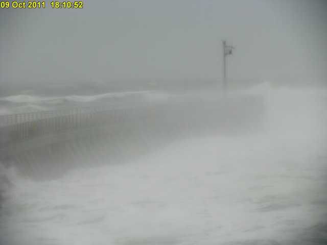
Daytona Beach Pier, huge waves, waves are reaching all the way to the boardwalk's seawall.
http://www.sunglowpierlive.com
http://www.volusia.org/beach/daytona.htm
Sebastian Inlet:
Daytona Beach Pier, huge waves, waves are reaching all the way to the boardwalk's seawall.
http://www.sunglowpierlive.com
http://www.volusia.org/beach/daytona.htm
0 likes

Re: ATL: INVEST 93L - Discussion
wait, this is suppose to move across the state or keep going north?
0 likes
Just like Jon Snow..."I know nothing" except what I know, and most of what I know is gathered by the fine people of the NHC
Winds keep increasing at PAFB.
Conditions at: KCOF (PATRICK AFB/COCO, FL, US) observed 2255 UTC 09 October 2011
Temperature: 22.5°C (72°F)
Dewpoint: 20.6°C (69°F) [RH = 89%]
Pressure (altimeter): 29.74 inches Hg (1007.2 mb)
[Sea-level pressure: 1007.3 mb]
Winds: from the NNE (30 degrees) at 48 MPH (42 knots; 21.8 m/s)
gusting to 57 MPH (50 knots; 26.0 m/s)
Visibility: 4 miles (6 km)
Ceiling: at least 12,000 feet AGL
Clouds: few clouds at 800 feet AGL
Weather: -RA BR (light rain, mist)
0 likes
-
chris_fit

- Category 5

- Posts: 3261
- Age: 43
- Joined: Wed Sep 10, 2003 11:58 pm
- Location: Tampa Bay Area, FL
Re: ATL: INVEST 93L - Discussion
Seems like the LLC is moving NW or so... but the heavy convection almost due W
http://radar.weather.gov/radar.php?rid= ... 1&loop=yes
http://radar.weather.gov/radar.php?rid= ... 1&loop=yes
0 likes
-
brunota2003
- S2K Supporter
- Posts: 9476
- Age: 35
- Joined: Sat Jul 30, 2005 9:56 pm
- Location: Stanton, KY...formerly Havelock, NC
- Contact:
-
AJC3

- Admin

- Posts: 4153
- Age: 62
- Joined: Tue Aug 31, 2004 7:04 pm
- Location: Ballston Spa, New York
- Contact:
Re:
brunota2003 wrote:What are the winds going to be like in that western band where all those reds are? I see winds of 50 to 55 knots ~800 feet off the ground east of Cocoa Beach, which would put ground winds in the 50 to 55 mph range...what about as that band moves ashore? Could there be higher winds?
I'll let you know when they get here. They'll be a lot stronger on the beach though - I live 9 miles west of there.
0 likes
-
brunota2003
- S2K Supporter
- Posts: 9476
- Age: 35
- Joined: Sat Jul 30, 2005 9:56 pm
- Location: Stanton, KY...formerly Havelock, NC
- Contact:
Re: ATL: INVEST 93L - Discussion
Conditions at
MELBOURNE INTERNATIONAL, FL, United States
2011.10.09 2253 UTC
Wind from the NNE (030 degrees) at 39 MPH (34 KT) gusting to 51 MPH (44 KT)
Visibility 2 mile(s)
Sky conditions mostly cloudy
Weather Light rain
Mist
Precipitation last hour 0.03 inches
Temperature 72.0 F (22.2 C)
Dew Point 70.0 F (21.1 C)
Relative Humidity 93%
Pressure (altimeter) 29.74 in. Hg (1007 hPa)
ob KMLB 092253Z 03034G44KT 2SM -RA BR SCT008 BKN017 BKN024 22/21 A2974 RMK AO2 PK WND 04046/2240 SLP070 P0003 T02220211
AJC3 wrote:brunota2003 wrote:What are the winds going to be like in that western band where all those reds are? I see winds of 50 to 55 knots ~800 feet off the ground east of Cocoa Beach, which would put ground winds in the 50 to 55 mph range...what about as that band moves ashore? Could there be higher winds?
I'll let you know when they get here. They'll be a lot stronger on the beach though - I live 9 miles west of there.
Be safe!
0 likes
New Smyrna also reporting wind gusts above 50 mph.
Current Weather Conditions:
New Smyrna Beach, New Smyrna Beach Municipal Airport, FL, United States
NWS Point Forecast for KEVB (KEVB) 29-03-20N 080-56-54W
--------------------------------------------------------------------------------
Conditions at Oct 09, 2011 - 06:47 PM EDTOct 09, 2011 2011.10.09 2247 UTC
Wind from the E (080 degrees) at 32 MPH (28 KT) gusting to 55 MPH (48 KT)
Visibility 3 mile(s)
Sky conditions overcast
Weather Light rain, mist
Temperature 71 F (22 C)
Dew Point 69 F (21 C)
Relative Humidity 94%
Pressure (altimeter) 29.83 in. Hg (1010 hPa)
ob KEVB 092247Z 08028G48KT 3SM -RABR BKN020 OVC050 22/21 A2983
0 likes
-
Ev1948
- S2K Supporter
- Posts: 65
- Joined: Mon Jun 28, 2010 6:16 pm
- Location: Florida USA -from South New Jersey
Re: ATL: INVEST 93L - Discussion
I live in Sebastian, between Vero and Palm Bay, I have no wind gauge, but the wind right now is blowing like he...double toothpicks..When will all this be out of here, we have been putting up with heavy rains, and wind , since Friday night.  Make it stop !!
  I have to go to Orlando Airport tomorrow to pick up family, flying in from NJ..
Evelyn
Evelyn
0 likes
-
SunnyThoughts
- Category 5
- Posts: 2263
- Joined: Wed Jul 09, 2003 12:42 pm
- Location: Pensacola, Florida
-
cycloneye

- Admin
- Posts: 149364
- Age: 69
- Joined: Thu Oct 10, 2002 10:54 am
- Location: San Juan, Puerto Rico
Re: ATL: INVEST 93L - Discussion
TROPICAL WEATHER OUTLOOK
NWS NATIONAL HURRICANE CENTER MIAMI FL
800 PM EDT SUN OCT 9 2011
FOR THE NORTH ATLANTIC...CARIBBEAN SEA AND THE GULF OF MEXICO...
SURFACE OBSERVATIONS...SATELLITE IMAGERY...AND WSR-88D DOPPLER RADAR
DATA FROM MELBOURNE FLORIDA INDICATE THAT A LOW PRESSURE AREA IS
LOCATED ABOUT 50 MILES SOUTHEAST OF CAPE CANAVERAL. ALTHOUGH THIS
SYSTEM DOES NOT HAVE A WELL-DEFINED SURFACE CENTER OF
CIRCULATION...IT IS PRODUCING GALE FORCE WINDS ALONG THE CENTRAL
EAST COAST OF FLORIDA AND EASTWARD OVER THE ATLANTIC FOR SEVERAL
HUNDRED MILES. THE LOW IS MOVING NORTHWESTWARD NEAR 10 MPH AND IS
EXPECTED TO MOVE INLAND OVER NORTH-CENTRAL FLORIDA BY MONDAY
MORNING...AND OVER THE EXTREME NORTHEASTERN GULF OF MEXICO OR NORTH
FLORIDA BY EARLY TUESDAY. AS LONG AS THE LOW REMAINS OVER
WATER...THERE IS STILL SOME POSSIBILITY OF DEVELOPMENT...AND THIS
SYSTEM HAS A MEDIUM CHANCE...30 PERCENT...OF BECOMING A SUBTROPICAL
CYCLONE DURING THE NEXT 48 HOURS. REGARDLESS OF DEVELOPMENT...
STRONG GUSTY WINDS AND LOCALLY HEAVY RAINFALL ARE EXPECTED OVER
PORTIONS OF THE SOUTHEASTERN UNITED STATES TODAY AND MONDAY. FOR
ADDITIONAL INFORMATION SPECIFIC TO YOUR AREA...INLUDING WATCHES OR
WARNINGS...PLEASE SEE STATEMENTS ISSUED BY YOUR LOCAL WEATHER
OFFICE.
ELSEWHERE...TROPICAL CYCLONE FORMATION IS NOT EXPECTED DURING THE
NEXT 48 HOURS.
$$
FORECASTER PASCH/CANGIALOSI
0 likes
Visit the Caribbean-Central America Weather Thread where you can find at first post web cams,radars
and observations from Caribbean basin members Click Here
and observations from Caribbean basin members Click Here

Re: ATL: INVEST 93L - Discussion
Yeah, this definitely looks subtropical, and making a fair run on tropical status from the radar presentation.

0 likes
-
Downdraft

- S2K Supporter
- Posts: 906
- Joined: Wed Oct 09, 2002 8:45 pm
- Location: Sanford, Florida
- Contact:
Re: ATL: INVEST 93L - Discussion
It walks like a duck, it looks like a duck but it must be chicken because it's so close to coming ashore. Hmmmmmm
0 likes

Re: ATL: INVEST 93L - Discussion
BigJoeBastardi Joe Bastardi
Earlier today, I understood, but one has to adapt and quickly to the rapidity of the weather. If Humberto (2007)could do it, so can this
1 minute ago
Joe Bastardi
BigJoeBastardi Joe Bastardi
My Point:You cant name storm like Jose, then have system this tight over 80 plus water impact US mainland in hurricane season and not name
1 minute ago
Joe Bastardi
BigJoeBastardi Joe Bastardi
respectfully disagree with TPC. Data buoy pressure is down 4 mb in 2 hours with gusts of 55-60. This is a tight system over warm water
0 likes
Just like Jon Snow..."I know nothing" except what I know, and most of what I know is gathered by the fine people of the NHC
-
Tampa_God

- Category 1

- Posts: 333
- Age: 36
- Joined: Wed May 31, 2006 7:27 pm
- Location: New Port Richey/Trinity, FL
Re: ATL: INVEST 93L - Discussion
Agree with JB. We have seen a couple weak Tropical Storms look way worse than this does at the moment. Add that with the radar image and date recently posted, it should be upgraded to a weak TS.
0 likes
-
cycloneye
- Admin
- Posts: 149364
- Age: 69
- Joined: Thu Oct 10, 2002 10:54 am
- Location: San Juan, Puerto Rico
Re: ATL: INVEST 93L - Discussion
00z Best Track
Up to 40kts and pressure down to 1005 mbs.
AL, 93, 2011101000, , BEST, 0, 280N, 800W, 40, 1005, SS
ftp://ftp.tpc.ncep.noaa.gov/atcf/tcweb/ ... 011.invest
Up to 40kts and pressure down to 1005 mbs.
AL, 93, 2011101000, , BEST, 0, 280N, 800W, 40, 1005, SS
ftp://ftp.tpc.ncep.noaa.gov/atcf/tcweb/ ... 011.invest
0 likes
Visit the Caribbean-Central America Weather Thread where you can find at first post web cams,radars
and observations from Caribbean basin members Click Here
and observations from Caribbean basin members Click Here
Re: ATL: INVEST 93L - Discussion
friends on the coast reporting wide spread power outages
0 likes
Just like Jon Snow..."I know nothing" except what I know, and most of what I know is gathered by the fine people of the NHC
-
viberama

- Tropical Depression

- Posts: 65
- Age: 53
- Joined: Mon Aug 01, 2011 7:36 pm
- Location: Orlando, FL
- Contact:
Re: ATL: INVEST 93L-Discussion -00z Best Track at 40kts,1005mbs
Had a 20kt gust here about 10 minutes ago. Power hasn't even flickered yet but I am about 5 miles from the coast. Knock on wood. Be safe everyone.
Last edited by viberama on Sun Oct 09, 2011 7:36 pm, edited 1 time in total.
0 likes
The following post is NOT an official forecast and should not be used as such. It is just my opinion and may or may not be backed by sound meteorological data. For Official Information please refer to the NHC and NWS products
Who is online
Users browsing this forum: No registered users and 28 guests