Texas Winter 2011-2012...
Moderator: S2k Moderators
Forum rules
 The posts in this forum are NOT official forecast and should not be used as such. They are just the opinion of the poster and may or may not be backed by sound meteorological data. They are NOT endorsed by any professional institution or STORM2K.

The posts in this forum are NOT official forecast and should not be used as such. They are just the opinion of the poster and may or may not be backed by sound meteorological data. They are NOT endorsed by any professional institution or STORM2K.
-
srainhoutx

- S2K Supporter

- Posts: 6919
- Age: 68
- Joined: Sun Jan 14, 2007 11:34 am
- Location: Haywood County, NC
- Contact:
Re: Texas Winter 2011-2012...
I see you haven’t been around the boards very long. This is a weather message board where folks discuss and learn from the Pro Mets and knowledgeable enthusiasts that have been a part of weather board history since their inception. They do serve a purpose and offer a lot of valuable information. Perhaps these type venues are not for you. There are many other highly technical boards to explore, but belittling anyone for their ‘comments’ or ‘thoughts’ does not benefit or add to the discussions, IMO… 
0 likes
Carla/Alicia/Jerry(In The Eye)/Michelle/Charley/Ivan/Dennis/Katrina/Rita/Wilma/Ike/Harvey
Member: National Weather Association
Wx Infinity Forums
http://wxinfinity.com/index.php
Facebook.com/WeatherInfinity
Twitter @WeatherInfinity
Member: National Weather Association
Wx Infinity Forums
http://wxinfinity.com/index.php
Facebook.com/WeatherInfinity
Twitter @WeatherInfinity

Re: Texas Winter 2011-2012...
wxman57 wrote:Let's abandon the subject of -removed-, OK? Besides, we all know the temperature across Texas will be in the upper 80s next week, right?
It's winter and we have to be cold. Perhaps abandoning -removed- may bring on the freeze.
0 likes
-
Rgv20

- S2K Supporter
- Posts: 2466
- Age: 39
- Joined: Wed Jan 05, 2011 5:42 pm
- Location: Edinburg/McAllen Tx
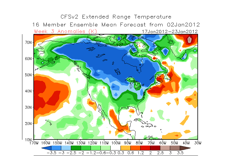
The CFS Weeklies for the first time is showing widespread below normal temperatures across the US...It's going to be interesting to see what future models runs show!
0 likes
The following post is NOT an official forecast and should not be used as such. It is just the opinion of the poster and may or may not be backed by sound meteorological data. It is NOT endorsed by any professional institution including storm2k.org For Official Information please refer to the NHC and NWS products.
-
austinrunner
Re: Texas Winter 2011-2012...
srainhoutx wrote:I see you haven’t been around the boards very long.
Two years as a registered user. A lot longer than that as a lurker. Of course, I have no way of knowing how you define "very long."
0 likes
-
austinrunner
Re:
Rgv20 wrote:The CFS Weeklies for the first time is showing widespread below normal temperatures across the US.
The anomalies for Texas are not strong. And notice the more significant positive anomalies not far away on the Mexican plateau, which is often a source for warming in this state.
0 likes
-
orangeblood
- S2K Supporter
- Posts: 3895
- Joined: Tue Dec 15, 2009 6:14 pm
- Location: Fort Worth, TX
Re: Texas Winter 2011-2012...
Sorry austinrunner but anytime you see that time that kind of cold forecast across the majority of the continent this far out, you can almost guarantee it's underestimating it and usually ends up overwhelming the pattern. The density of arctic air like that this time of year will almost always undercut and beat those measly "warm anomalies" you're referring to everytime. Austinrunner, I would like to introduce to kettle and all of his -removed- little buddies!!
0 likes
-
aggiecutter
- Category 5

- Posts: 1755
- Joined: Thu Oct 14, 2004 9:22 pm
- Location: Texarkana
Re: Texas Winter 2011-2012...
Interesting stuff from Larry Cosgrove tonight.
http://www.examiner.com/weather-in-hous ... ary-4-2012
http://www.examiner.com/weather-in-hous ... ary-4-2012
0 likes
-
weatherdude1108
- Category 5
- Posts: 4228
- Joined: Tue Dec 13, 2011 1:04 pm
- Location: Northwest Austin/Cedar Park, TX
Re: Texas Winter 2011-2012...
aggiecutter wrote:Interesting stuff from Larry Cosgrove tonight.
http://www.examiner.com/weather-in-hous ... ary-4-2012
Bring it! I hope Larry is right. I'd feel better about our winter storm chances if the potential systems had more snowpack-chilled real estate to our north with which to work.
0 likes
The preceding post is NOT an official forecast, and should not be used as such. It is only the opinion of the poster and may or may not be backed by sound meteorological data. It is NOT endorsed by any professional institution including storm2k.org. For Official Information please refer to the NHC and NWS products.
-
Rgv20
- S2K Supporter
- Posts: 2466
- Age: 39
- Joined: Wed Jan 05, 2011 5:42 pm
- Location: Edinburg/McAllen Tx
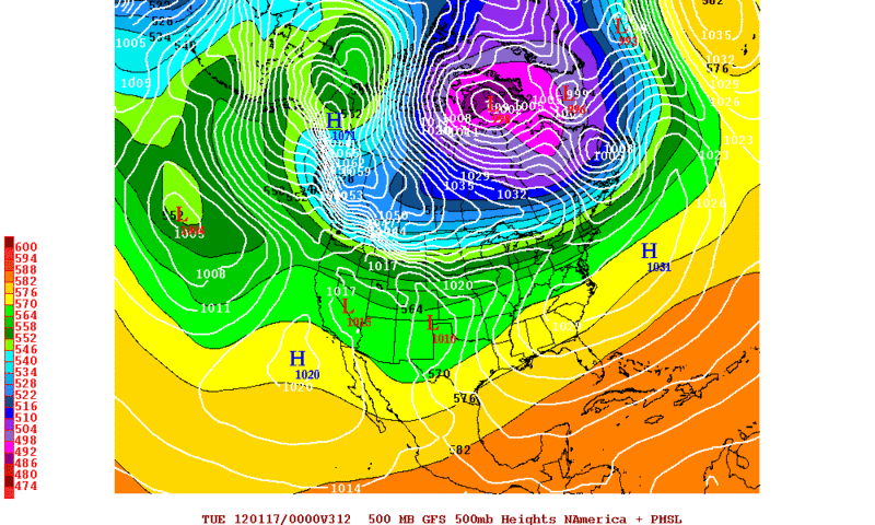
Warning the following forecast of the 0zGFS is for entertainment purposes only!.......1071mb HIGH just SE of Alaska at 312hrs 
0 likes
The following post is NOT an official forecast and should not be used as such. It is just the opinion of the poster and may or may not be backed by sound meteorological data. It is NOT endorsed by any professional institution including storm2k.org For Official Information please refer to the NHC and NWS products.
-
orangeblood
- S2K Supporter
- Posts: 3895
- Joined: Tue Dec 15, 2009 6:14 pm
- Location: Fort Worth, TX
Re: Texas Winter 2011-2012...
Yikes!!! That is a monster Arctic High moving into Western Canada 8 days from now shown by the 0Z GFS.
0 likes


Lol that's funny even for the long range. Have we ever seen a 1070+ high on a GFS map in modern times before? I can recall a couple of 1060s though couple times last year and a few more I think back in 07.
0 likes
The above post and any post by Ntxw is NOT an official forecast and should not be used as such. It is just the opinion of the poster and may or may not be backed by sound meteorological data. It is NOT endorsed by any professional institution including Storm2k. For official information, please refer to NWS products.
Help support Storm2K!
-
orangeblood
- S2K Supporter
- Posts: 3895
- Joined: Tue Dec 15, 2009 6:14 pm
- Location: Fort Worth, TX
Re:
Ntxw wrote:Lol that's funny even for the long range. Have we ever seen a 1070+ high on a GFS map in modern times before? I can recall a couple of 1060s though couple times last year and a few more I think back in 07.
I think I recall seeing one last year on the GFS and Camadian several days before the early February outbreak. We don't see it very often with the GFS depicting arctic outbreaks like this but when we do it usually becomes verifiable in some form or fashion.
Another note: IMO, these stratospheric warming episodes seem to be the most reliable tool in predicting arctic outbreaks across the lower 48....they take a few weeks to evolve but are almost always on cue!!
0 likes
-
Rgv20
- S2K Supporter
- Posts: 2466
- Age: 39
- Joined: Wed Jan 05, 2011 5:42 pm
- Location: Edinburg/McAllen Tx
Re: Re:
orangeblood wrote:I think I recall seeing one last year on the GFS and Camadian several days before the early February outbreak. We don't see it very often with the GFS depicting arctic outbreaks like this but when we do it usually becomes verifiable in some form or fashion.
Agree with the fact that when GFS forecasts crazy things like that it's trying to sniff out something.....A turn to a cooler pattern after mid month for the lower 48 is picking up steam! I dont know if you did it on purpose but Camadian (Comedian?) is a good nickname for the CMC!
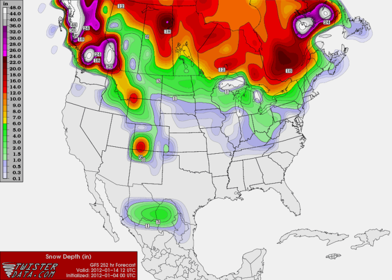
By late next week 0zGFS is forecasting some snow for the mountains of Mexico and parts of Texas..Long shot but worth mentioning it.
0 likes
The following post is NOT an official forecast and should not be used as such. It is just the opinion of the poster and may or may not be backed by sound meteorological data. It is NOT endorsed by any professional institution including storm2k.org For Official Information please refer to the NHC and NWS products.
-
austinrunner
Re:
Ntxw wrote:Lol that's funny even for the long range. Have we ever seen a 1070+ high on a GFS map in modern times before? I can recall a couple of 1060s though couple times last year and a few more I think back in 07.
Yeah, last year. What happened then? As one poster said on January 9:
Yes, where did the record high pressure go??? I really think the GFS predicts an ice age every year no matter what.
0 likes

Re: Texas Winter 2011-2012...
austinrunner wrote:Yeah, last year. What happened then? As one poster said on January 9:Yes, where did the record high pressure go??? I really think the GFS predicts an ice age every year no matter what.
I don't think anyone expects a 1070 high pressure coming down. But, it's a sign of a colder pattern to come. As you recall, February 1st came with a strong arctic front, and we had ice and snow on the ground for a few days.
0 likes
-
austinrunner
Re: Texas Winter 2011-2012...
That's really stretching the facts to say that a GFS prediction for early January 2011 had much to do with the cold outbreak one month later.
0 likes
Re: Texas Winter 2011-2012...
austinrunner wrote:That's really stretching the facts to say that a GFS prediction for early January 2011 had much to do with the cold outbreak one month later.
I don't think so. If you look at all the other models and all the other data. There are definite signs that a colder pattern is coming. Usually, when the GFS hints at these sort of things for an extended period of time, a change usually comes. It might get pushed back, and it won't be as intense. But, I don't think there is anything wrong with saying that it looks like a colder pattern is coming.
0 likes
Some 0z updates: Euro/CMC/GFS have come in warmer and very far to the west with the early week system so based on today's runs probably a cool down then some rain followed by a warm up. A different tune is that they develop a kicker storm that wasn't there in previous runs behind it.
0 likes
The above post and any post by Ntxw is NOT an official forecast and should not be used as such. It is just the opinion of the poster and may or may not be backed by sound meteorological data. It is NOT endorsed by any professional institution including Storm2k. For official information, please refer to NWS products.
Help support Storm2K!
Help support Storm2K!
-
austinrunner
Re: Texas Winter 2011-2012...
iorange55 wrote:There are definite signs that a colder pattern is coming.
A colder pattern for whom is the relevant question. The same questionable model (GFS) that's predicting the monster surface high in western Canada never lowers 500 mb heights at 30 degrees north in Texas below 570. It's a flat pattern that pushes the really cold air towards the Great Lakes, not Texas.
Compare the forecast:
http://wxweb.meteostar.com/models/ipsm_looper.php?PROD=2012010400_NAM_GFS_500_HGT_WINDS
with the classic pattern for a severe arctic outbreak in south Texas as described in this paper:
http://www.srh.noaa.gov/ssd/techmemo/tm88.htm
The significance of the 500 mb features associated with freeze events in the Lower Rio Grande Valley is that they are recognizable several days before the freeze event. Forecasters preparing extended outlooks and agricultural weather forecasts for the Lower Rio Grande Valley should be able to interpret the 500 mb and surface analyses and progs, in conjunction with other synoptic reasoning and centrally prepared guidance, in terms of likelihood of a damaging freeze.
The recognition guidelines for 500 mb patterns which may indicate a freeze are:
1. A short wave omega block superimposed on a long wave ridge through central Alaska with a deep low system between Hudson Bay and Greenland.
2. An east-west trough line over southern Canada or the northern United States with zonal flow and a strong jet to the south and northerly flow to the north of the trough line.
3. A closed low moving southward through the Prairie Provinces of Canada developing into a long wave trough, without cyclogenesis.
4. Discontinuous retrogression of a full-latitude trough over the western United States involving a closed low or major east-west short-wave moving southward without cyclogenesis.
5. A sharp full-latitude trough, frequently with a closed low, over the southeastern states.
Last edited by austinrunner on Wed Jan 04, 2012 2:31 am, edited 2 times in total.
0 likes
Re: Texas Winter 2011-2012...
austinrunner wrote:iorange55 wrote:There are definite signs that a colder pattern is coming.
A colder pattern for whom is the relevant question. The same questionable model (GFS) that's predicting the monster surface high in western Canada never lowers 500 mb heights at 30 degrees north in Texas beyond 570. It's a flat pattern that pushes the really cold air towards the Great Lakes, not Texas.
This is not always the case. Shallow arctic air is not always accompanied with extremely low heights especially. In the case of the December 1989 outbreak heights were only between 564 and 552 but at the same time featured single digits to below zero.
http://www.meteo.psu.edu/~gadomski/NARR/1989/us1222.php
The same is said for another significant outbreak in December of 1983
http://www.meteo.psu.edu/~gadomski/NARR/1983/us1223.php
Pretty mind boggling if you ask me
Last edited by Ntxw on Wed Jan 04, 2012 2:00 am, edited 2 times in total.
0 likes
The above post and any post by Ntxw is NOT an official forecast and should not be used as such. It is just the opinion of the poster and may or may not be backed by sound meteorological data. It is NOT endorsed by any professional institution including Storm2k. For official information, please refer to NWS products.
Help support Storm2K!
Help support Storm2K!
Who is online
Users browsing this forum: No registered users and 110 guests