King Euro has been much kinder to this old man's backside.
Texas Winter 2011-2012...
Moderator: S2k Moderators
Forum rules
 The posts in this forum are NOT official forecast and should not be used as such. They are just the opinion of the poster and may or may not be backed by sound meteorological data. They are NOT endorsed by any professional institution or STORM2K.

The posts in this forum are NOT official forecast and should not be used as such. They are just the opinion of the poster and may or may not be backed by sound meteorological data. They are NOT endorsed by any professional institution or STORM2K.
-
Portastorm

- Storm2k Moderator

- Posts: 9955
- Age: 63
- Joined: Fri Jul 11, 2003 9:16 am
- Location: Round Rock, TX
- Contact:
Re: Texas Winter 2011-2012...
No doubt. Many of us have been duped over the years by the GFS spinning up winter storms, Arctic outbreaks, and general wintry mayhem. That's why I started the whole "Charlie Brown trying to kick the football with Lucy" thing. Just when you think you can trust the GFS, it yanks the ball from you and you end up on your backside! 
King Euro has been much kinder to this old man's backside.
King Euro has been much kinder to this old man's backside.
0 likes
Any forecasts under my name are to be taken with a grain of salt. Get your best forecasts from the National Weather Service and National Hurricane Center.
-
Palmer divide shadow
- Tropical Depression

- Posts: 54
- Joined: Thu Dec 29, 2011 11:15 am
- Location: Monument Colorado,but from Sugarland tx
Re: Texas Winter 2011-2012...
That cold wave actually was the coldest in 20 years for many and lots of records and in some cases alltime records were broken.
0 likes
-
Portastorm
- Storm2k Moderator
- Posts: 9955
- Age: 63
- Joined: Fri Jul 11, 2003 9:16 am
- Location: Round Rock, TX
- Contact:
Larry Cosgrove's blog post tonight ought to get some tongues wagging ...
http://www.examiner.com/weather-in-houston/houston-tx-and-vicinity-weather-forecast-thursday-january-5-2012
http://www.examiner.com/weather-in-houston/houston-tx-and-vicinity-weather-forecast-thursday-january-5-2012
0 likes
Any forecasts under my name are to be taken with a grain of salt. Get your best forecasts from the National Weather Service and National Hurricane Center.
-
ThunderSleetDreams

- S2K Supporter

- Posts: 1510
- Age: 43
- Joined: Tue Dec 20, 2011 4:42 pm
- Location: S of Weimar, TX
Re: Texas Winter 2011-2012...
I have a gut feeling w are in for a pretty epic end to January
0 likes
#NeverSummer
I hibernate when it gets above 75 degrees!
I hibernate when it gets above 75 degrees!
-
TeamPlayersBlue

- Category 5

- Posts: 3530
- Joined: Tue Feb 02, 2010 1:44 am
- Location: Denver/Applewood, CO
If only the arctic air were coming down in time for the low pressure arrival on Monday...
0 likes
Personal Forecast Disclaimer:
The posts in this forum are NOT official forecast and should not be used as such. They are just the opinion of the poster and may or may not be backed by sound meteorological data. They are NOT endorsed by any professional institution or storm2k.org. For official information, please refer to the NHC and NWS products.
The posts in this forum are NOT official forecast and should not be used as such. They are just the opinion of the poster and may or may not be backed by sound meteorological data. They are NOT endorsed by any professional institution or storm2k.org. For official information, please refer to the NHC and NWS products.
-
weatherdude1108
- Category 5
- Posts: 4228
- Joined: Tue Dec 13, 2011 1:04 pm
- Location: Northwest Austin/Cedar Park, TX
Re: Texas Winter 2011-2012...
orangeblood wrote:Ntxw wrote:orangeblood wrote:One thing is for sure, the GFS has been very consistent on brutally cold air building across Canada next week. This brutally cold air, if it was to verify, will be very dense and should beat the models as far as the southern extent of the arctic boundary. Wherever this boundary sets up, thats where the fun and games should be and would expect the models to trend further south with time!! imo
Have you taken a look at the warming forecasts lately for the stratosphere? The next wave seems to be even stronger and has potential to beat down the PV even more!
http://www.cpc.ncep.noaa.gov/products/stratosphere/strat_a_f/
Yeah, it makes you think this pattern might lock and hold for awhile. Those would be some crazy height rises building across Alaska into the Yukon Territory, if this forecast were to verify, possibly making the Arctic Express train quite long...sending one Arctic High after another into the lower latitudes.
I was looking at that stratosphere page, and I got confused. What am I looking at? How do you
figure out what's coming down the Arctic "pipe" from the mass of data on this page? Trying to
narrow it down and simplify it. I'm just not familiar with this stratosphere page. Thanks for your
help.
0 likes

Re: Texas Winter 2011-2012...
weatherdude1108 wrote:I was looking at that stratosphere page, and I got confused. What am I looking at? How do you
figure out what's coming down the Arctic "pipe" from the mass of data on this page? Trying to
narrow it down and simplify it. I'm just not familiar with this stratosphere page. Thanks for your
help.
It can be a complex thing to learn, but from my miniscule of knowledge regarding such if you take a look at that page scroll down and look for "NCEP/GFS Analyses and Forecasts" >temperature. That is the GFS forecast for temps in the stratosphere (click on the NH ones, it's for the northern hemisphere, 10-70mb is usually good places to look at). Usually when the AO+ is present it is cold all over the arctic stratospheric regions with no warm anomalies with a strong PV. That has been the regime in December, all of the cold is bottled up there.
From what I've read, a SSW or MWW (same things), warm temperature surges disturb the cold PV (AO+) and if strong enough can send it into the troposphere (where our weather is) hence bringing down cold with it. More/stronger warming waves can also then push it into the lower latitudes once present in the troposphere (AO-), and that is when we begin the arctic march! If anyone wants to add or correct feel free, this is all from reading so hopefully I got it down enough!
Think of it as warm air expands, cold air condenses. As the stratosphere warms it expands, and the troposphere has to condense.
0 likes
The above post and any post by Ntxw is NOT an official forecast and should not be used as such. It is just the opinion of the poster and may or may not be backed by sound meteorological data. It is NOT endorsed by any professional institution including Storm2k. For official information, please refer to NWS products.
Help support Storm2K!
-
Texas Snowman

- Storm2k Moderator
- Posts: 6197
- Joined: Fri Jan 25, 2008 11:29 am
- Location: Denison, Texas
Re:
Portastorm wrote:Larry Cosgrove's blog post tonight ought to get some tongues wagging ...
http://www.examiner.com/weather-in-houston/houston-tx-and-vicinity-weather-forecast-thursday-january-5-2012
Same line of thought, here are some tweets from today from WeatherBell's Joe B:
"Remember week one: mild week two turning wild. Week three cold thats vile."
"This looks like a coast to coast cold threat. Portland Oregon to Portland Maine.. perhaps to the ports of Houston and new Orleans too."
"Cross Polar flow, look out below."
0 likes
The above post and any post by Texas Snowman is NOT an official forecast and should not be used as such. It is just the opinion of the poster and may or may not be backed by sound meteorological data. It is NOT endorsed by any professional institution including storm2k.org. For official information, please refer to NWS products.
-
BigB0882
- S2K Supporter
- Posts: 2292
- Joined: Thu Jul 03, 2003 12:08 am
- Location: Baton Rouge, LA
- Contact:
At least things are getting interesting. Hope it does get cold.
By the way, the GFS did hint at record cold last year and it wasn't that far off! We had about 36 hours below freezing all the way down to the coast with freezing rain and sleet for many areas. It was the coldest I can remember in a very long time, especially since it lasted for more than just one night.
By the way, the GFS did hint at record cold last year and it wasn't that far off! We had about 36 hours below freezing all the way down to the coast with freezing rain and sleet for many areas. It was the coldest I can remember in a very long time, especially since it lasted for more than just one night.
0 likes
-
Texas Snowman
- Storm2k Moderator
- Posts: 6197
- Joined: Fri Jan 25, 2008 11:29 am
- Location: Denison, Texas
Two more late night tweets from Joe Bastardi:
"GFS Ensembles are continuing to echo ideas that the biggest mid winter flip since 2007 is on the way. Ugly cold evolving lt nxweek/beyond."
"strong troughs day 7-10 has canadian archipelago air.. cold but not as cold as what follows week 3 ..cross polar air. pattern may lock."
"GFS Ensembles are continuing to echo ideas that the biggest mid winter flip since 2007 is on the way. Ugly cold evolving lt nxweek/beyond."
"strong troughs day 7-10 has canadian archipelago air.. cold but not as cold as what follows week 3 ..cross polar air. pattern may lock."
0 likes
The above post and any post by Texas Snowman is NOT an official forecast and should not be used as such. It is just the opinion of the poster and may or may not be backed by sound meteorological data. It is NOT endorsed by any professional institution including storm2k.org. For official information, please refer to NWS products.
-
Rgv20

- S2K Supporter
- Posts: 2466
- Age: 39
- Joined: Wed Jan 05, 2011 5:42 pm
- Location: Edinburg/McAllen Tx
Tonight's new operational 0zGFS never actually develops the blocking across Alaska/Bering Sea in the longer range but the 0zGFS Ensembles still hold firm and the eventual colder pattern change for the lower 48 after mid month.
0zGFS Ensembles 500mb Height anomalies forecast valid for Sunday Evening Jan 15. The Ensembles still holding firm on positive 500mb Height Anomalies over the Bering Sea/Western Alaska.
0zGFS Ensembles 500mb Height anomalies forecast valid for Sunday Evening Jan 15. The Ensembles still holding firm on positive 500mb Height Anomalies over the Bering Sea/Western Alaska.
0 likes
The following post is NOT an official forecast and should not be used as such. It is just the opinion of the poster and may or may not be backed by sound meteorological data. It is NOT endorsed by any professional institution including storm2k.org For Official Information please refer to the NHC and NWS products.
Re: Texas Winter 2011-2012...
Hmm I wonder why no one has mentioned the Canadian for Monday/Tuesday. I don't know surface data, but it looks awfully similar to the JMA.

Uploaded with ImageShack.us

Uploaded with ImageShack.us
0z GFS about the same time frame.

Uploaded with ImageShack.us

Uploaded with ImageShack.us

Uploaded with ImageShack.us
0z GFS about the same time frame.

Uploaded with ImageShack.us
Last edited by Ntxw on Thu Jan 05, 2012 1:06 am, edited 2 times in total.
0 likes
The above post and any post by Ntxw is NOT an official forecast and should not be used as such. It is just the opinion of the poster and may or may not be backed by sound meteorological data. It is NOT endorsed by any professional institution including Storm2k. For official information, please refer to NWS products.
Help support Storm2K!
Help support Storm2K!
-
Rgv20
- S2K Supporter
- Posts: 2466
- Age: 39
- Joined: Wed Jan 05, 2011 5:42 pm
- Location: Edinburg/McAllen Tx
0zCMC is interesting for you folks in North Texas!
Forecast valid for Monday Evening. Some one may get a wintery surprise!

Forecast valid for Monday Evening. Some one may get a wintery surprise!
0 likes
The following post is NOT an official forecast and should not be used as such. It is just the opinion of the poster and may or may not be backed by sound meteorological data. It is NOT endorsed by any professional institution including storm2k.org For Official Information please refer to the NHC and NWS products.
-
TeamPlayersBlue
- Category 5
- Posts: 3530
- Joined: Tue Feb 02, 2010 1:44 am
- Location: Denver/Applewood, CO
The GFS Monday to Tuesday brought back the possibility of some wintry weather for SE TExas too.
0 likes
Personal Forecast Disclaimer:
The posts in this forum are NOT official forecast and should not be used as such. They are just the opinion of the poster and may or may not be backed by sound meteorological data. They are NOT endorsed by any professional institution or storm2k.org. For official information, please refer to the NHC and NWS products.
The posts in this forum are NOT official forecast and should not be used as such. They are just the opinion of the poster and may or may not be backed by sound meteorological data. They are NOT endorsed by any professional institution or storm2k.org. For official information, please refer to the NHC and NWS products.
0z Euro is somewhat slower and not as cold as the other two, but has a very potent slow moving system. Very impressive shape to it just needs colder air, could be some good heavy rains ahead of it. Behind the system euro has a disturbance in Cal/AZ border as polar air is making it's way into Texas behind the first storm.

Uploaded with ImageShack.us

Uploaded with ImageShack.us
0 likes
The above post and any post by Ntxw is NOT an official forecast and should not be used as such. It is just the opinion of the poster and may or may not be backed by sound meteorological data. It is NOT endorsed by any professional institution including Storm2k. For official information, please refer to NWS products.
Help support Storm2K!
Help support Storm2K!
-
Portastorm
- Storm2k Moderator
- Posts: 9955
- Age: 63
- Joined: Fri Jul 11, 2003 9:16 am
- Location: Round Rock, TX
- Contact:
Re: Texas Winter 2011-2012...
For those here who think most of us only post when we see Arctic outbreaks or winter storms on the horizon ...
None of the 0z operational runs (GFS, Euro, CMC, or UKie) show polar air plunging towards Texas in the next 6-10 days. In fact, there is a lot of model disparity this morning and still, within that mixed up bunch, none of them are showing any "excitement" from what I can tell beyond this weekend's upper low (and that's only on some of the models).
None of the 0z operational runs (GFS, Euro, CMC, or UKie) show polar air plunging towards Texas in the next 6-10 days. In fact, there is a lot of model disparity this morning and still, within that mixed up bunch, none of them are showing any "excitement" from what I can tell beyond this weekend's upper low (and that's only on some of the models).
0 likes
Any forecasts under my name are to be taken with a grain of salt. Get your best forecasts from the National Weather Service and National Hurricane Center.
-
Texas Snowman
- Storm2k Moderator
- Posts: 6197
- Joined: Fri Jan 25, 2008 11:29 am
- Location: Denison, Texas
Re: Texas Winter 2011-2012...
Several interesting tweets this morning.
First two from @Henry_Margusity:
"It's been a week now that the SOI values have been way down to indicate a neutral ENSO or barely a La Nina."
"The euro model shows the pattern change of true arctic air by the 13th. That means colder then it is now."
-----
Second, a couple from @BigJoeBastardi:
"Even in mild patterns, fun and games.. southern rockies snow perhaps into Texas west of I-35 for Sunday/Monday."
"Next fla freeze threat next weekend.. remember mild then wild, then cold that is vile... weather evolution for U.S next 3 weeks."
0 likes
The above post and any post by Texas Snowman is NOT an official forecast and should not be used as such. It is just the opinion of the poster and may or may not be backed by sound meteorological data. It is NOT endorsed by any professional institution including storm2k.org. For official information, please refer to NWS products.
-
Texas Snowman
- Storm2k Moderator
- Posts: 6197
- Joined: Fri Jan 25, 2008 11:29 am
- Location: Denison, Texas
Looking at some forecast discussions from NWS offices north of DFW this morning. Interesting to see if this front is the beginning of a pattern change that does lead to serious cold by month's end.
-----
Norman NWS: "BY THE MIDDLE OF NEXT WEEK, AN UPPER WAVE COMING DOWN FROM CANADA COULD BRING IN SOME CONSIDERABLY COLDER AIR BEGINNING ON WEDNESDAY."
Tulsa NWS: "COLDER AIR WILL SURGE SWD WEDNESDAY INTO THURSDAY AS THE UPPER LOW EXITS TO THE EAST. HAVE KEPT THE LINGERING WRAP-AROUND PRECIP ON WEDNESDAY ALL LIQUID FOR NOW...BUT WILL WATCH THIS CLOSELY. MUCH COLDER WEATHER WILL SETTLE IN FOR LATE NEXT WEEK...WITH TEMPS DROPPING BACK TO AROUND OR BELOW NORMAL."
Amarillo NWS: "A POTENT ARCTIC COLD FRONT ASSOCIATED WITH THIS COLD AIR LOOKS TO MOVE ACROSS THE FORECAST AREA ON WEDNESDAY WITH THE POSSIBILITY OF COLD TEMPERATURES RETURNING JUST BEYOND THIS FORECAST PERIOD. THE GOOD NEWS IS THAT THE MOST EXTREME COLD SHOULD STAY NORTH AND EAST OF
THE PANHANDLES."
Wichita NWS: "MODELS BOTH CONTINUE TO SHOW AN ARCTIC SURGE FOR THE MIDDLE OF THE WEEK ON THE BACKSIDE OF THIS SYSTEM. THIS WILL CERTAINLY REMIND EVERYONE THAT THIS IS STILL JANUARY."
0 likes
The above post and any post by Texas Snowman is NOT an official forecast and should not be used as such. It is just the opinion of the poster and may or may not be backed by sound meteorological data. It is NOT endorsed by any professional institution including storm2k.org. For official information, please refer to NWS products.
-
weatherdude1108
- Category 5
- Posts: 4228
- Joined: Tue Dec 13, 2011 1:04 pm
- Location: Northwest Austin/Cedar Park, TX
Re: Texas Winter 2011-2012...
Ntxw wrote:weatherdude1108 wrote:I was looking at that stratosphere page, and I got confused. What am I looking at? How do you
figure out what's coming down the Arctic "pipe" from the mass of data on this page? Trying to
narrow it down and simplify it. I'm just not familiar with this stratosphere page. Thanks for your
help.
It can be a complex thing to learn, but from my miniscule of knowledge regarding such if you take a look at that page scroll down and look for "NCEP/GFS Analyses and Forecasts" >temperature. That is the GFS forecast for temps in the stratosphere (click on the NH ones, it's for the northern hemisphere, 10-70mb is usually good places to look at). Usually when the AO+ is present it is cold all over the arctic stratospheric regions with no warm anomalies with a strong PV. That has been the regime in December, all of the cold is bottled up there.
From what I've read, a SSW or MWW (same things), warm temperature surges disturb the cold PV (AO+) and if strong enough can send it into the troposphere (where our weather is) hence bringing down cold with it. More/stronger warming waves can also then push it into the lower latitudes once present in the troposphere (AO-), and that is when we begin the arctic march! If anyone wants to add or correct feel free, this is all from reading so hopefully I got it down enough!
Think of it as warm air expands, cold air condenses. As the stratosphere warms it expands, and the troposphere has to condense.
That definitely helps! Makes total sense visualizing as the stratosphere warms, the troposphere has no choice but to condense/compress and take the path of least resistance. Thank you so much!
0 likes
The preceding post is NOT an official forecast, and should not be used as such. It is only the opinion of the poster and may or may not be backed by sound meteorological data. It is NOT endorsed by any professional institution including storm2k.org. For Official Information please refer to the NHC and NWS products.
-
aggiecutter
- Category 5
- Posts: 1755
- Joined: Thu Oct 14, 2004 9:22 pm
- Location: Texarkana
Re: Texas Winter 2011-2012...
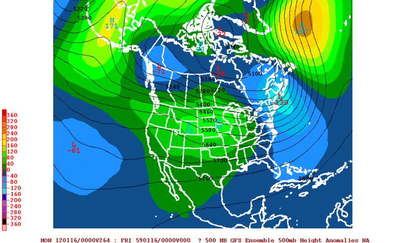
Portastorm wrote:For those here who think most of us only post when we see Arctic outbreaks or winter storms on the horizon ...
None of the 0z operational runs (GFS, Euro, CMC, or UKie) show polar air plunging towards Texas in the next 6-10 days. In fact, there is a lot of model disparity this morning and still, within that mixed up bunch, none of them are showing any "excitement" from what I can tell beyond this weekend's upper low (and that's only on some of the models).
Looking at this mornings' GFS Ensemble, it looks like the first significant piece of cold air will come down the middle of next week. However, at the end of the period, above normal heights at the pole with lower heights east of the Rockies should make for a more intense and prolonged arctic outbreak. However, there is still a lot of variance in each of the ensemble members as to where the positive and negative anomalies will be located. This is quite typical when you have a pattern change.
The preceding post is NOT an official forecast and should not be used as such. It is just the opinion of the poster and may or may not be backed by sound meteorological data. It is NOT endorsed by any professional institution including storm2k.org. For official information, please refer to NWS products.
0 likes
Who is online
Users browsing this forum: No registered users and 104 guests