Texas Winter 2011-2012...

Winter Weather Discussion

Moderator: S2k Moderators

Forum rules

The posts in this forum are NOT official forecast and should not be used as such. They are just the opinion of the poster and may or may not be backed by sound meteorological data. They are NOT endorsed by any professional institution or STORM2K.

Help Support Storm2K
Message
Author
User avatar
Portastorm
Storm2k Moderator
Storm2k Moderator
Posts: 9914
Age: 63
Joined: Fri Jul 11, 2003 9:16 am
Location: Round Rock, TX
Contact:

Re: Texas Winter 2011-2012...

#2561 Postby Portastorm » Fri Feb 03, 2012 6:19 pm

Portastorm wrote:Rgv, I don't know about 40s Sunday here ... but it is possible based on those model runs you referenced. Current NWS forecast says low 50s. Regardless, I'm liking how our QPF values have risen up to about 1.25 inches for this coming event. Every little bit helps!


Update for my friend in the Valley ... our temps are now progged for mid 40s on Sunday with rain. Good call on those model runs!
0 likes   
Any forecasts under my name are to be taken with a grain of salt. Get your best forecasts from the National Weather Service and National Hurricane Center.

User avatar
Rgv20
S2K Supporter
S2K Supporter
Posts: 2466
Age: 38
Joined: Wed Jan 05, 2011 5:42 pm
Location: Edinburg/McAllen Tx

#2562 Postby Rgv20 » Fri Feb 03, 2012 6:59 pm

:uarrow: Hope you enjoyed those cool temps up in Austin! Im looking forward for some rain this weekend with highs in the upper 50s for Sunday :P ....Hey when the high today was 87F, 50s are going to feel cold! :lol:


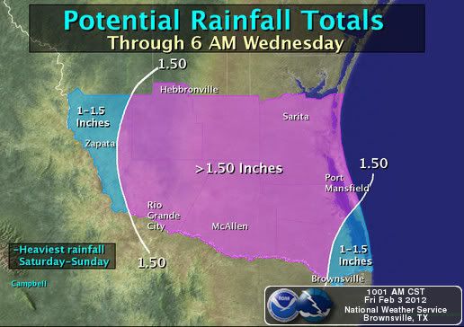
Hopefully this forecast Map verifies :D

Image
Periods of rain will follow a cold front late Saturday and Sunday, perhaps lingering into early Monday. Current forecasts suggest between 1 and 2 inches Valley-wide through Monday with more rain beginning late Tuesday and increasing Wednesday.
0 likes   
The following post is NOT an official forecast and should not be used as such. It is just the opinion of the poster and may or may not be backed by sound meteorological data. It is NOT endorsed by any professional institution including storm2k.org For Official Information please refer to the NHC and NWS products.

User avatar
Texas Snowman
Storm2k Moderator
Storm2k Moderator
Posts: 6179
Joined: Fri Jan 25, 2008 11:29 am
Location: Denison, Texas

#2563 Postby Texas Snowman » Fri Feb 03, 2012 10:41 pm

A year ago tonight, my front yard was covered in several inches of snow and sleet.

Tonight it was covered in ice again. This time it was covered by pea to nickel sized hail from a severe thunderstorm that ripped through Denison. Not far away, golfball and egg sized hail fell.
0 likes   
The above post and any post by Texas Snowman is NOT an official forecast and should not be used as such. It is just the opinion of the poster and may or may not be backed by sound meteorological data. It is NOT endorsed by any professional institution including storm2k.org. For official information, please refer to NWS products.

User avatar
jasons2k
Storm2k Executive
Storm2k Executive
Posts: 8245
Age: 51
Joined: Wed Jul 06, 2005 12:32 pm
Location: The Woodlands, TX

#2564 Postby jasons2k » Sat Feb 04, 2012 12:06 am

I noticed San Antonio is getting pounded pretty good tonight. And there are a lot of training storms near College Station and some damage reported in that area. Looks to be an active overnight with the highest risk being flooding. At least it will help or lakes and the drought!
0 likes   

User avatar
Rgv20
S2K Supporter
S2K Supporter
Posts: 2466
Age: 38
Joined: Wed Jan 05, 2011 5:42 pm
Location: Edinburg/McAllen Tx

#2565 Postby Rgv20 » Sat Feb 04, 2012 1:33 am

Severe Thunderstorm Warning

SEVERE THUNDERSTORM WARNING
TXC029-187-493-040700-
/O.NEW.KEWX.SV.W.0016.120204T0615Z-120204T0700Z/

BULLETIN - EAS ACTIVATION REQUESTED
SEVERE THUNDERSTORM WARNING
NATIONAL WEATHER SERVICE AUSTIN/SAN ANTONIO TX
1215 AM CST SAT FEB 4 2012

THE NATIONAL WEATHER SERVICE IN AUSTIN SAN ANTONIO HAS ISSUED A

* SEVERE THUNDERSTORM WARNING FOR...
EAST CENTRAL BEXAR COUNTY...
SOUTHWESTERN GUADALUPE COUNTY...
NORTH CENTRAL WILSON COUNTY...

* UNTIL 100 AM CST.

* AT 1211 AM CST...NWS METEOROLOGISTS HAVE DETECTED A SEVERE
THUNDERSTORM CAPABLE OF PRODUCING QUARTER SIZE HAIL...AND DAMAGING
WINDS IN EXCESS OF 60 MPH. THIS STORM WAS LOCATED NEAR ST.
HEDWIG...OR 9 MILES SOUTH OF UNIVERSAL CITY...AND MOVING EAST AT 15
MPH.

* SOME LOCATIONS IN THE WARNING INCLUDE LA VERNIA AND NEW BERLIN.

VERY HEAVY RAINS WITH RAINFALL RATES OF 2 TO 4 INCHES CAN ALSO BE
EXPECTED.
PRECAUTIONARY/PREPAREDNESS ACTIONS...

THIS IS A DANGEROUS STORM. IF YOU ARE IN ITS PATH...PREPARE
IMMEDIATELY FOR DAMAGING WINDS...DESTRUCTIVE HAIL...AND DEADLY CLOUD
TO GROUND LIGHTNING. PEOPLE OUTSIDE SHOULD MOVE TO A SHELTER...
PREFERABLY INSIDE A STRONG BUILDING BUT AWAY FROM WINDOWS.

&&

LAT...LON 2957 9807 2933 9805 2937 9831 2950 9831
TIME...MOT...LOC 0615Z 269DEG 12KT 2942 9825

$$


FLASH FLOOD STATEMENT
NATIONAL WEATHER SERVICE AUSTIN/SAN ANTONIO TX
1213 AM CST SAT FEB 4 2012

TXC029-040800-
/O.CON.KEWX.FF.W.0012.000000T0000Z-120204T0800Z/
/00000.0.ER.000000T0000Z.000000T0000Z.000000T0000Z.OO/
BEXAR TX-
1213 AM CST SAT FEB 4 2012

...A FLASH FLOOD WARNING REMAINS IN EFFECT UNTIL 200 AM CST FOR
CENTRAL BEXAR COUNTY...

AT 1206 AM CST...NATIONAL WEATHER SERVICE METEOROLOGISTS CONTINUED TO
DETECT THUNDERSTORMS PRODUCING FLASH FLOODING FROM NEAR KELLY FIELD
TO BALCONES HEIGHTS TO SAN ANTONIO INTERNATIONAL AIRPORT AND FROM
KIRBY TO SCHERTZ. RAINFALL RATES OF 2 TO 4 INCHES PER HOUR CAN BE
EXPECTED.

LOCATIONS IN THE WARNING AREA INCLUDE UNIVERSAL CITY...SHAVANO
PARK...LIVE OAK...HOLLYWOOD PARK...HILL COUNTRY VILLA AND SELMA.

PRECAUTIONARY/PREPAREDNESS ACTIONS...

RUNOFF FROM HEAVY RAIN WILL FLOOD CREEKS, STREAMS, STREET
INTERSECTIONS, CULVERTS AND UNDERPASSES. LOW LYING PLACES THAT
NORMALLY FLOOD COULD BECOME DEATH TRAPS. DO NOT CROSS ANY FLOODED
AREA. TURN AROUND DON`T DROWN.

WHEN WATER COVERS THE ROAD...TURN AROUND DON`T DROWN. THE LIFE YOU
SAVE MAY BE YOUR OWN.

&&

LAT...LON 2960 9863 2965 9835 2962 9834 2959 9831
2956 9830 2954 9826 2943 9822 2939 9861

$$
0 likes   
The following post is NOT an official forecast and should not be used as such. It is just the opinion of the poster and may or may not be backed by sound meteorological data. It is NOT endorsed by any professional institution including storm2k.org For Official Information please refer to the NHC and NWS products.

User avatar
Rgv20
S2K Supporter
S2K Supporter
Posts: 2466
Age: 38
Joined: Wed Jan 05, 2011 5:42 pm
Location: Edinburg/McAllen Tx

#2566 Postby Rgv20 » Sat Feb 04, 2012 2:14 am

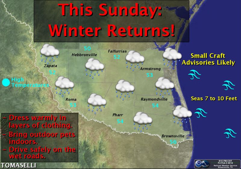
Classic winter day shaping up for the Valley this Sunday....Highs in the low 50s with overunning rain :D

Image
Cloudy skies with light rain and moderate winds from the north will produce cold weather on Sunday after several recent days of above normal temperatures. Adverse marine conditions are also expected due to strong winds offshore, with Small Craft Advisories likely on that day. -Tomaselli
0 likes   
The following post is NOT an official forecast and should not be used as such. It is just the opinion of the poster and may or may not be backed by sound meteorological data. It is NOT endorsed by any professional institution including storm2k.org For Official Information please refer to the NHC and NWS products.

User avatar
Portastorm
Storm2k Moderator
Storm2k Moderator
Posts: 9914
Age: 63
Joined: Fri Jul 11, 2003 9:16 am
Location: Round Rock, TX
Contact:

Re: Texas Winter 2011-2012...

#2567 Postby Portastorm » Sat Feb 04, 2012 7:52 am

Alright folks, for the second major medium-range model cycle in a row (I don't count the 6z and 18z), we see a +PNA developing with a western ridge/eastern trough pattern in about six days. To me this is significant because I don't recall seeing such consistency from the GFS and Euro as of late. The question remains where will that ridge set up and how sharp will the trough be (not to mention what happens with the polar vortex in terms of location)? That will dictate whether Texas sees a glancing blow from the Arctic air or a major blast or little/anything.

Your Grey Goose-swilling mets will be all likkered up, er, watching carefully all weekend at the Portastorm Weather Center. :wink:
0 likes   
Any forecasts under my name are to be taken with a grain of salt. Get your best forecasts from the National Weather Service and National Hurricane Center.

User avatar
vbhoutex
Storm2k Executive
Storm2k Executive
Posts: 29112
Age: 73
Joined: Wed Oct 09, 2002 11:31 pm
Location: Cypress, TX
Contact:

Re: Texas Winter 2011-2012...

#2568 Postby vbhoutex » Sat Feb 04, 2012 9:18 am

Portastorm wrote:Alright folks, for the second major medium-range model cycle in a row (I don't count the 6z and 18z), we see a +PNA developing with a western ridge/eastern trough pattern in about six days. To me this is significant because I don't recall seeing such consistency from the GFS and Euro as of late. The question remains where will that ridge set up and how sharp will the trough be (not to mention what happens with the polar vortex in terms of location)? That will dictate whether Texas sees a glancing blow from the Arctic air or a major blast or little/anything.

Your Grey Goose-swilling mets will be all likkered up, er, watching carefully all weekend at the Portastorm Weather Center. :wink:

Gives me pause/goose bumps :lol: to read this. Glad to know the PWC mets are all READY to forecast for us and keep us updated. :cheesy:
0 likes   
Skywarn, C.E.R.T.
Please click below to donate to STORM2K to help with the expenses of keeping the site going:
Image

Dean4Storms
S2K Supporter
S2K Supporter
Posts: 6358
Age: 62
Joined: Sun Aug 31, 2003 1:01 pm
Location: Miramar Bch. FL

#2569 Postby Dean4Storms » Sat Feb 04, 2012 9:37 am

JB pointed out here with good pics how the ECMWF continues the last 4 runs with a deeper and deeper trough in the east......

http://twitter.com/#!/BigJoeBastardi/st ... 08/photo/1
0 likes   

User avatar
wxman57
Moderator-Pro Met
Moderator-Pro Met
Posts: 22979
Age: 67
Joined: Sat Jun 21, 2003 8:06 pm
Location: Houston, TX (southwest)

Re: Texas Winter 2011-2012...

#2570 Postby wxman57 » Sat Feb 04, 2012 9:43 am

Euro is coldest, indicating temps way down into the MID 30s for southeast Texas in 9 days.
0 likes   

User avatar
Tireman4
S2K Supporter
S2K Supporter
Posts: 5853
Age: 59
Joined: Fri Jun 30, 2006 1:08 pm
Location: Humble, Texas
Contact:

#2571 Postby Tireman4 » Sat Feb 04, 2012 9:57 am

After yesterday's torture 7 mile run, I am sooo glad to see this. Woo Hoo....
0 likes   

User avatar
Portastorm
Storm2k Moderator
Storm2k Moderator
Posts: 9914
Age: 63
Joined: Fri Jul 11, 2003 9:16 am
Location: Round Rock, TX
Contact:

Re: Texas Winter 2011-2012...

#2572 Postby Portastorm » Sat Feb 04, 2012 10:08 am

wxman57 wrote:Euro is coldest, indicating temps way down into the MID 30s for southeast Texas in 9 days.


Mid 30s? Ah heck ...we can do better than that. :lol:

Admit it, you'd be uncomfortable on that nifty bike of yours in mid 30s. I'll see what the PWC mets can do about lowering that temperature some more.
0 likes   
Any forecasts under my name are to be taken with a grain of salt. Get your best forecasts from the National Weather Service and National Hurricane Center.

User avatar
Ntxw
Storm2k Moderator
Storm2k Moderator
Posts: 22786
Joined: Wed Oct 21, 2009 6:34 pm
Location: DFW, Texas

#2573 Postby Ntxw » Sat Feb 04, 2012 10:48 am

I've been going through op and ensemble runs this morning. Models are not seeing these big arctic highs coming down the Canadian prairies until close range. What makes them legit? Hudson bay vortex is settling in along with -epo ride in alaska. This means the highs go south, most likely more than one given the duration of the +pna. Stepping down process...
0 likes   
The above post and any post by Ntxw is NOT an official forecast and should not be used as such. It is just the opinion of the poster and may or may not be backed by sound meteorological data. It is NOT endorsed by any professional institution including Storm2k. For official information, please refer to NWS products.

  Help support Storm2K!
Help Support Storm2K

User avatar
wxman57
Moderator-Pro Met
Moderator-Pro Met
Posts: 22979
Age: 67
Joined: Sat Jun 21, 2003 8:06 pm
Location: Houston, TX (southwest)

Re: Texas Winter 2011-2012...

#2574 Postby wxman57 » Sat Feb 04, 2012 1:59 pm

Portastorm wrote:
wxman57 wrote:Euro is coldest, indicating temps way down into the MID 30s for southeast Texas in 9 days.


Mid 30s? Ah heck ...we can do better than that. :lol:

Admit it, you'd be uncomfortable on that nifty bike of yours in mid 30s. I'll see what the PWC mets can do about lowering that temperature some more.


Good news! New (12Z) Euro has our lows in the mid 50s next Saturday and mid 60s Sunday. No more mid 30s. Neither the 12Z Euro nor the 12Z GFS has temps in east Texas anywhere close to the mid 30s over the next 15 days.

Still raining in SW Houston. Now at 12.5" for the year. Last year, it took all the way to mid October to reach 12.5".
0 likes   

Palmer divide shadow
Tropical Depression
Tropical Depression
Posts: 54
Joined: Thu Dec 29, 2011 11:15 am
Location: Monument Colorado,but from Sugarland tx

#2575 Postby Palmer divide shadow » Sat Feb 04, 2012 2:04 pm

I bet the grass is really green.even for febuary.
0 likes   

User avatar
jasons2k
Storm2k Executive
Storm2k Executive
Posts: 8245
Age: 51
Joined: Wed Jul 06, 2005 12:32 pm
Location: The Woodlands, TX

#2576 Postby jasons2k » Sat Feb 04, 2012 2:04 pm

I had .62" overnight. I thought I'd have more, but still good :D
0 likes   

weatherdude1108
Category 5
Category 5
Posts: 4228
Joined: Tue Dec 13, 2011 1:04 pm
Location: Northwest Austin/Cedar Park, TX

#2577 Postby weatherdude1108 » Sat Feb 04, 2012 2:58 pm

I had only sprinkles last night in my yard during the big flash flood event. Not measurable. About 20 miles give or take east and south, they had flooding problems. Depended totally on your location.
0 likes   

User avatar
vbhoutex
Storm2k Executive
Storm2k Executive
Posts: 29112
Age: 73
Joined: Wed Oct 09, 2002 11:31 pm
Location: Cypress, TX
Contact:

Re:

#2578 Postby vbhoutex » Sat Feb 04, 2012 4:02 pm

jasons wrote:I had .62" overnight. I thought I'd have more, but still good :D

I've had over 2" in the last 24 hours. Reported 1.90" to CoCoRahs this am while it was still raining. I've had over 7" of rain so far this year. It took till sometime in the summer to get there last year.
0 likes   
Skywarn, C.E.R.T.
Please click below to donate to STORM2K to help with the expenses of keeping the site going:
Image

User avatar
Portastorm
Storm2k Moderator
Storm2k Moderator
Posts: 9914
Age: 63
Joined: Fri Jul 11, 2003 9:16 am
Location: Round Rock, TX
Contact:

Re: Texas Winter 2011-2012...

#2579 Postby Portastorm » Sat Feb 04, 2012 4:57 pm

The King of Warm mongerers is correct in that both the 12z GFS and Euro have kind of backed off on their "colder" look from the 0z cycle. Haven't looked at the ensembles yet. The 12z UKMet, however, is very aggressive with Arctic air by later next week but it seems the outlier at the moment.
0 likes   
Any forecasts under my name are to be taken with a grain of salt. Get your best forecasts from the National Weather Service and National Hurricane Center.

User avatar
wxman57
Moderator-Pro Met
Moderator-Pro Met
Posts: 22979
Age: 67
Joined: Sat Jun 21, 2003 8:06 pm
Location: Houston, TX (southwest)

Re: Texas Winter 2011-2012...

#2580 Postby wxman57 » Sat Feb 04, 2012 8:01 pm

Another 2 1/2" of rain today. That's 12.32" for the year, just about what I'd measured from January through October last year.
0 likes   


Return to “Winter Weather”

Who is online

Users browsing this forum: No registered users and 13 guests