Texas Winter 2011-2012...

Winter Weather Discussion

Moderator: S2k Moderators

Forum rules

The posts in this forum are NOT official forecast and should not be used as such. They are just the opinion of the poster and may or may not be backed by sound meteorological data. They are NOT endorsed by any professional institution or STORM2K.

Help Support Storm2K
Message
Author
User avatar
Rgv20
S2K Supporter
S2K Supporter
Posts: 2466
Age: 38
Joined: Wed Jan 05, 2011 5:42 pm
Location: Edinburg/McAllen Tx

Re:

#2681 Postby Rgv20 » Thu Feb 09, 2012 9:30 pm

Rgv20 wrote:Okay I did a little bit of research as to which years would be good analog years for this upcoming winter season and IMO 1950-51,1956-57,1971-72,1974-75,1989-90,and 2008-09 could mirror this winter season. Also I wont be surprise if we would get a Severe Arctic Front during this winter season. Does Dec 1989 bring memories?

This map represents the Temperature Anomalies from Nov thru Jan.
Image


This map represents the Precipitation Anomalies from Nov thru Jan.
Image


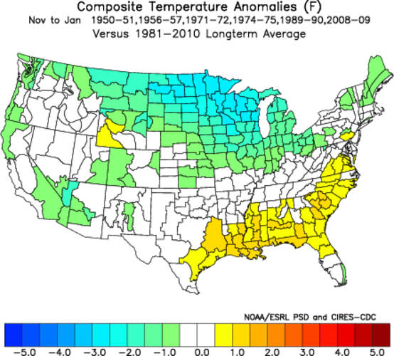
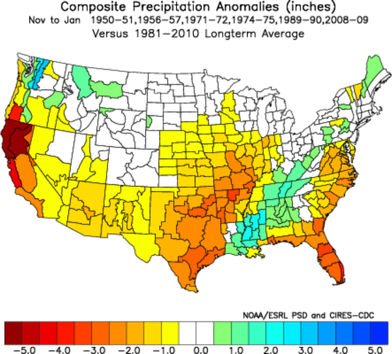
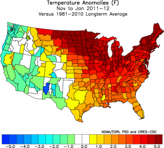
Just wanted to look back to see how the analog years I picked on September stacked up...Keep in mind it only from Nov thru Jan.

In regards to Temperature Anomalies no comment! :lol:
Image


Regarding the Precipitation Anomalies it did sort of follow the analogs. Surprisingly much of Texas had above normal rainfall for the period for being a La Nina winter but with the historic drought we have had it was a blessing! :D
Image
0 likes   
The following post is NOT an official forecast and should not be used as such. It is just the opinion of the poster and may or may not be backed by sound meteorological data. It is NOT endorsed by any professional institution including storm2k.org For Official Information please refer to the NHC and NWS products.

orangeblood
S2K Supporter
S2K Supporter
Posts: 3714
Joined: Tue Dec 15, 2009 6:14 pm
Location: Fort Worth, TX

Re: Texas Winter 2011-2012...

#2682 Postby orangeblood » Fri Feb 10, 2012 12:08 am

Right when the MJO is coming around into its favorable phases for the southern plains, there is almost no significant cold air to tap into whatsoever!!! Unlike the last couple of winters, the block has worked against us this year...trapping all of the cold air across Europe and Asia
0 likes   

User avatar
Texas Snowman
Storm2k Moderator
Storm2k Moderator
Posts: 6179
Joined: Fri Jan 25, 2008 11:29 am
Location: Denison, Texas

Re: Texas Winter 2011-2012...

#2683 Postby Texas Snowman » Fri Feb 10, 2012 12:42 am

orangeblood wrote:Right when the MJO is coming around into its favorable phases for the southern plains, there is almost no significant cold air to tap into whatsoever!!! Unlike the last couple of winters, the block has worked against us this year...trapping all of the cold air across Europe and Asia


Despite the apparent glee that wxman57 has in crushing our hopes this winter, I am far from giving up. 8-)

I mean, come on, it's February 9th and we all have seen the unreliability of the models outside of a few days out.

Having seen three big North Texas snows in mid March the last several years, I would heartily disagree with our King of Warmth that it's all over for Texas from the Dallas area south.

I'd say that there's still a good month left for the region of I-20 north to keep their hopes alive.
0 likes   
The above post and any post by Texas Snowman is NOT an official forecast and should not be used as such. It is just the opinion of the poster and may or may not be backed by sound meteorological data. It is NOT endorsed by any professional institution including storm2k.org. For official information, please refer to NWS products.

User avatar
Texas Snowman
Storm2k Moderator
Storm2k Moderator
Posts: 6179
Joined: Fri Jan 25, 2008 11:29 am
Location: Denison, Texas

#2684 Postby Texas Snowman » Fri Feb 10, 2012 12:46 am

:uarrow: Case in point, check out the latest tweets tonight by Joe Bastardi.

While he is admittedly talking about I-40 north, it wouldn't take much of a buckle in the storm track along with some chilly air and evaporative cooling to give North Texas a shot at some snow if this comes to pass.


@BigJoeBastardi: "Then something I have had for a couple of days, a 2cnd storm next week deep blue heaviest snow , system for Mon/Tue http://pic.twitter.com/chMxzz8z"


@BigJoeBastardi: "For much of US if spring is around the corner.. its a long haul to the end of the block ( ripped off from the great Elliot Abrams)."


@BigJoeBastardi: "Most places n of I-40 going to see enough snow to challenge the winter totals for normal in the next 3-4 weeks. Blocking on euro impressive."
0 likes   
The above post and any post by Texas Snowman is NOT an official forecast and should not be used as such. It is just the opinion of the poster and may or may not be backed by sound meteorological data. It is NOT endorsed by any professional institution including storm2k.org. For official information, please refer to NWS products.

gpsnowman
S2K Supporter
S2K Supporter
Posts: 3185
Joined: Fri Jan 07, 2011 10:35 am
Location: Grand Prairie Tx

#2685 Postby gpsnowman » Fri Feb 10, 2012 12:58 am

:uarrow: I sure hope you are right. Regardless of precip, the colder temps this weekend will be pretty darn chilly. Can't wait to feel that cold air with a little wind! Mid 20's for lows. Something we have not felt much of this winter.
0 likes   

User avatar
Ntxw
Storm2k Moderator
Storm2k Moderator
Posts: 22785
Joined: Wed Oct 21, 2009 6:34 pm
Location: DFW, Texas

#2686 Postby Ntxw » Fri Feb 10, 2012 1:22 am

GFS has trended closer to Euro and Canadian (remember a few days ago everything was in Kansas?). I would like to mention the 0z euro has come in colder and shows wintry precip From Midland to just north of Waco (and everyone else inbetween) this coming Sunday/Monday. It is one run so far that has extended it that far south. Still have a lot of runs to go, though a few days ago I think it did also once. It's going to be a race between how fast the precip moves in and/or how quickly the cold air moves out. Right now based on how things have gone the past several days, my early bet is that if one were to "snow chase" nearby, Paris/Bonham would be ideal.

Edit: I forgot about the Ukmet, it's not that different from the Euro. One thing else I did notice is that 540 thickness is far to the north which makes me wonder if someone could have problems with ice if the cold air retreats a little slower than anticipated, especially in northeast Texas.
0 likes   
The above post and any post by Ntxw is NOT an official forecast and should not be used as such. It is just the opinion of the poster and may or may not be backed by sound meteorological data. It is NOT endorsed by any professional institution including Storm2k. For official information, please refer to NWS products.

  Help support Storm2K!
Help Support Storm2K

User avatar
Texas Snowman
Storm2k Moderator
Storm2k Moderator
Posts: 6179
Joined: Fri Jan 25, 2008 11:29 am
Location: Denison, Texas

Re: Texas Winter 2011-2012...

#2687 Postby Texas Snowman » Fri Feb 10, 2012 6:12 am

Whoa! Where did this come from? I thought that there wasn't ANY cold air out there. :wink:

Here's the chilly forecast - sunny skies and all - for Sherman/Denison tomorrow:

Saturday: Mostly sunny, with a high near 34. Wind chill values between 10 and 20. North northeast wind between 10 and 20 mph, with gusts as high as 25 mph.

Saturday Night: Partly cloudy, with a low around 21. East northeast wind between 5 and 10 mph.
0 likes   
The above post and any post by Texas Snowman is NOT an official forecast and should not be used as such. It is just the opinion of the poster and may or may not be backed by sound meteorological data. It is NOT endorsed by any professional institution including storm2k.org. For official information, please refer to NWS products.

Snowman67
Category 2
Category 2
Posts: 633
Joined: Thu Dec 31, 2009 12:44 pm
Location: Tomball, TX

Re: Texas Winter 2011-2012...

#2688 Postby Snowman67 » Fri Feb 10, 2012 6:46 am

wxman57 wrote:True, the models are clueless beyond a few days out. However, there's still no cold air in western Canada (or Alaska now). Can't get cold in Texas if temps are well above normal in western Canada. I think we've seen our last freeze in Houston, though I do need a 29F low at IAH for the forecast contest.


Not so fast my heat miser friend. NWS now forecasting a widespread freeze Saturday night for areas north of Wharton-Houston-Winnie line. IAH forecasting a low of 31F.
0 likes   
Any forecast I make is based on my opinion only. Please refer to the NWS or NHC for official forecasts.

Palmer divide shadow
Tropical Depression
Tropical Depression
Posts: 54
Joined: Thu Dec 29, 2011 11:15 am
Location: Monument Colorado,but from Sugarland tx

#2689 Postby Palmer divide shadow » Fri Feb 10, 2012 7:17 am

There is cold air available ,most of its in north central canada sliding south and east.this weekends cold shot is an example of not always needing western Canada as a source region for cold to move south.90 percent if the time you do,but this is one of the exceptions.
0 likes   

User avatar
wxman57
Moderator-Pro Met
Moderator-Pro Met
Posts: 22979
Age: 67
Joined: Sat Jun 21, 2003 8:06 pm
Location: Houston, TX (southwest)

Re: Texas Winter 2011-2012...

#2690 Postby wxman57 » Fri Feb 10, 2012 8:42 am

Snowman67 wrote:
wxman57 wrote:True, the models are clueless beyond a few days out. However, there's still no cold air in western Canada (or Alaska now). Can't get cold in Texas if temps are well above normal in western Canada. I think we've seen our last freeze in Houston, though I do need a 29F low at IAH for the forecast contest.


Not so fast my heat miser friend. NWS now forecasting a widespread freeze Saturday night for areas north of Wharton-Houston-Winnie line. IAH forecasting a low of 31F.


Seriously? A possible light freeze north of Houston in mid February is a sign of bitter cold in Canada? Enjoy the last gasps of winter over the next few days. Highs in Houston will be topping 80 by the last week of February. ;-)

Image
0 likes   

HockeyTx82
S2K Supporter
S2K Supporter
Posts: 2540
Joined: Tue Oct 27, 2009 11:17 am
Location: Ponder, TX

Re: Texas Winter 2011-2012...

#2691 Postby HockeyTx82 » Fri Feb 10, 2012 9:21 am

Well tomorrow morning should fun. I am running the Hot Chocolate 15k in Dallas. Race starts around 8 but I will be there earlier than that. It looks to be pretty cold. At least I will get to finally try out my new winter running gear I got for Christmas this year. :cold: :cold:

Forecast for Dallas from the NWS as of this morning.

Tonight: Mostly clear, with a low around 24. North wind around 10 mph.

Saturday: Mostly sunny, with a high near 40. North northeast wind between 10 and 20 mph, with gusts as high as 25 mph.

Saturday Night: Partly cloudy, with a low around 24. East northeast wind between 5 and 10 mph.

I don't get this, does the Wind Chill not apply south of Denton? Forecast for Denton as of this morning as well........ :double:

Tonight: Mostly clear, with a low around 21. North wind around 10 mph.

Saturday: Mostly sunny, with a high near 37. Wind chill values between 9 and 19. North northeast wind between 10 and 20 mph, with gusts as high as 25 mph.

Saturday Night: Partly cloudy, with a low around 21. East northeast wind between 5 and 10 mph.
0 likes   
Don't hold me accountable for anything I post on this forum. Leave the real forecasting up to the professionals.

Location: Ponder, TX (all observation posts are this location unless otherwise noted)

User avatar
CaptinCrunch
S2K Supporter
S2K Supporter
Posts: 8728
Age: 57
Joined: Mon Nov 03, 2003 4:33 pm
Location: Kennedale, TX (Tarrant Co.)

Re: Texas Winter 2011-2012...

#2692 Postby CaptinCrunch » Fri Feb 10, 2012 9:35 am

THE GFS/EC/CMC MODELS NOW REMARKABLY IN GOOD AGREEMENT ON THE UPPER
FEATURES MOVING THROUGH THE WEST COAST AND ACROSS THE PLAINS THROUGH
DAY07. HOWEVER...AT THE SURFACE THERE REMAINS SOME DISCREPANCY
CONCERNING CYCLOGENESIS ON WEDNESDAY AND THE TRACK OF THE SURFACE
LOW ACROSS TEXAS WEDNESDAY INTO THURSDAY.

ALSO...BOTH MODELS AGREE ON TRANSPORTING COLD CANADIAN HIGH
PRESSURE SOUTHWARD INTO THE STATE TONIGHT THEN SLIDING IT INTO THE
LOWER MISSISSIPPI RIVER VALLEY ON SUNDAY. TONIGHT WILL BE VERY
COLD WITH A HARD FREEZE ACROSS MOST OF NORTH TEXAS SATURDAY AND
SUNDAY MORNINGS.

ANOTHER SHORTWAVE SYSTEM WILL MOVE ACROSS NORTH TEXAS SUNDAY
THROUGH MONDAY. PARTIAL THICKNESSES INDICATE SOME PRECIPITATION
MIGHT FALL AS A RAIN/SLEET MIX SUNDAY EVENING IN THE NORTHWEST
COUNTIES BEFORE WARM ADVECTION ALOFT TRANSITION THE POTENTIAL TO
ALL RAIN LATE SUNDAY NIGHT THROUGH MONDAY.
FORECAST SOUNDINGS DO
NOT SHOW MUCH POTENTIAL FOR THUNDER...BUT HAVE INCLUDED ISOLATED
THUNDER GENERALLY ALONG AND SOUTH OF I-20 DURING THIS EVENT.


I think the NWS FTW Office may have to rethink the Sunday night Monday morning event. The chance to see more sleet and some ice may be greater than they think.
0 likes   

Snowman67
Category 2
Category 2
Posts: 633
Joined: Thu Dec 31, 2009 12:44 pm
Location: Tomball, TX

Re: Texas Winter 2011-2012...

#2693 Postby Snowman67 » Fri Feb 10, 2012 9:38 am

wxman57 wrote:
Snowman67 wrote:
wxman57 wrote:True, the models are clueless beyond a few days out. However, there's still no cold air in western Canada (or Alaska now). Can't get cold in Texas if temps are well above normal in western Canada. I think we've seen our last freeze in Houston, though I do need a 29F low at IAH for the forecast contest.


Not so fast my heat miser friend. NWS now forecasting a widespread freeze Saturday night for areas north of Wharton-Houston-Winnie line. IAH forecasting a low of 31F.


Seriously? A possible light freeze north of Houston in mid February is a sign of bitter cold in Canada? Enjoy the last gasps of winter over the next few days. Highs in Houston will be topping 80 by the last week of February. ;-)

Image


I wasn't making any reference to the temps in Canada, just your statement about Houston having seen it's last freeze. I will enjoy any and all winter that we have left and hoping the temp goes below 32F at IAH on Saturday night to notch another freeze. Look on the bright side - the forecast for IAH is only 2 degrees warmer than what you need for your forecast contest :D
0 likes   
Any forecast I make is based on my opinion only. Please refer to the NWS or NHC for official forecasts.

gpsnowman
S2K Supporter
S2K Supporter
Posts: 3185
Joined: Fri Jan 07, 2011 10:35 am
Location: Grand Prairie Tx

#2694 Postby gpsnowman » Fri Feb 10, 2012 9:53 am

Fox 4 Evan Andrews mentioned sleet possible Sunday night. The forecasted temps temps this weekend continue to get colder and colder.
0 likes   

User avatar
Tireman4
S2K Supporter
S2K Supporter
Posts: 5853
Age: 59
Joined: Fri Jun 30, 2006 1:08 pm
Location: Humble, Texas
Contact:

Re: Texas Winter 2011-2012...

#2695 Postby Tireman4 » Fri Feb 10, 2012 9:54 am

HockeyTx82 wrote:Well tomorrow morning should fun. I am running the Hot Chocolate 15k in Dallas. Race starts around 8 but I will be there earlier than that. It looks to be pretty cold. At least I will get to finally try out my new winter running gear I got for Christmas this year. :cold: :cold:


My best friend is too. He is aiming for a 6:45 pace. I am thinking, the way his intervals have been going, he should be close (3x1 mile at 5:45 pace). He should do well in our age group (45-49). Good luck to you.
0 likes   

orangeblood
S2K Supporter
S2K Supporter
Posts: 3714
Joined: Tue Dec 15, 2009 6:14 pm
Location: Fort Worth, TX

Re:

#2696 Postby orangeblood » Fri Feb 10, 2012 10:31 am

Ntxw wrote:GFS has trended closer to Euro and Canadian (remember a few days ago everything was in Kansas?). I would like to mention the 0z euro has come in colder and shows wintry precip From Midland to just north of Waco (and everyone else inbetween) this coming Sunday/Monday. It is one run so far that has extended it that far south. Still have a lot of runs to go, though a few days ago I think it did also once. It's going to be a race between how fast the precip moves in and/or how quickly the cold air moves out. Right now based on how things have gone the past several days, my early bet is that if one were to "snow chase" nearby, Paris/Bonham would be ideal.

Edit: I forgot about the Ukmet, it's not that different from the Euro. One thing else I did notice is that 540 thickness is far to the north which makes me wonder if someone could have problems with ice if the cold air retreats a little slower than anticipated, especially in northeast Texas.


Ntxw - With the high pressure oriented the way its forecast by most models, I just don't see that ice scenario unfolding. Winds will be out of a southeasterly direction and that normally spells disaster for those wanting winter weather. I think you would need winds out of the north-northeast to hold the dense cold air at the surface. It looks like there might be a few flakes on the front end of the precip shield but will transition to rain fairly quickly.
0 likes   

User avatar
wxman57
Moderator-Pro Met
Moderator-Pro Met
Posts: 22979
Age: 67
Joined: Sat Jun 21, 2003 8:06 pm
Location: Houston, TX (southwest)

Re: Texas Winter 2011-2012...

#2697 Postby wxman57 » Fri Feb 10, 2012 10:44 am

HockeyTx82 wrote: ... snip...
I don't get this, does the Wind Chill not apply south of Denton? Forecast for Denton as of this morning as well........ :double:

Tonight: Mostly clear, with a low around 21. North wind around 10 mph.

Saturday: Mostly sunny, with a high near 37. Wind chill values between 9 and 19. North northeast wind between 10 and 20 mph, with gusts as high as 25 mph.

Saturday Night: Partly cloudy, with a low around 21. East northeast wind between 5 and 10 mph.


21F with a 10 and 20 mph wind = a wind chill between 6 and 10F. A temp of 37 with a 20 mph wind = a wind chill of 27F. So on average, a wind chill of between 9 and 19 isn't TOO bad, though 19 value should be more like 30.

http://www.nws.noaa.gov/os/windchill/index.shtml
0 likes   

ndale
Category 1
Category 1
Posts: 429
Joined: Tue Dec 29, 2009 11:12 am
Location: Pflugerville/Austin Tx

#2698 Postby ndale » Fri Feb 10, 2012 10:56 am

Austin wfo likes to use the word "conundrum" when they don't know what to expect with wintry precipitation, it is in their forecast this morning: THE CONUNDRUM IS THE POTENTIAL FOR A WINTERY MIX ACROSS
THE EDWARDS PLATEAU AND HILL COUNTRY SUNDAY MORNING. THERE ARE
INDICATIONS THAT SOME SLEET MAY BE MIXED WITH THE RAIN AS THE PCPN
SHIELD OVERSPREADS THE EDWARDS PLATEAU AND HILL COUNTRY SUNDAY
MORNING. ATTM CONFIDENCE IS LOW FOR THIS SCENARIO SO HAVE LEFT
SLEET OUT OF THE FCST.
0 likes   
Any opinions stated are those of an amateur, please take with several grains of salt and for official forecast refer to the National Weather Service.

HockeyTx82
S2K Supporter
S2K Supporter
Posts: 2540
Joined: Tue Oct 27, 2009 11:17 am
Location: Ponder, TX

Re: Texas Winter 2011-2012...

#2699 Postby HockeyTx82 » Fri Feb 10, 2012 10:56 am

wxman57 wrote:
HockeyTx82 wrote: ... snip...
I don't get this, does the Wind Chill not apply south of Denton? Forecast for Denton as of this morning as well........ :double:

Tonight: Mostly clear, with a low around 21. North wind around 10 mph.

Saturday: Mostly sunny, with a high near 37. Wind chill values between 9 and 19. North northeast wind between 10 and 20 mph, with gusts as high as 25 mph.

Saturday Night: Partly cloudy, with a low around 21. East northeast wind between 5 and 10 mph.


21F with a 10 and 20 mph wind = a wind chill between 6 and 10F. A temp of 37 with a 20 mph wind = a wind chill of 27F. So on average, a wind chill of between 9 and 19 isn't TOO bad, though 19 value should be more like 30.

http://www.nws.noaa.gov/os/windchill/index.shtml


Ah I see. I guess I was more confused as to why the Denton forecast mentions wind chill values and the Dallas one does not. Either way should be fun times tomorrow.
0 likes   
Don't hold me accountable for anything I post on this forum. Leave the real forecasting up to the professionals.

Location: Ponder, TX (all observation posts are this location unless otherwise noted)

natlib
Tropical Storm
Tropical Storm
Posts: 159
Joined: Tue Dec 01, 2009 10:09 am
Location: San Angelo, TX

Re: Texas Winter 2011-2012...

#2700 Postby natlib » Fri Feb 10, 2012 11:13 am

No winter cancel in West Texas............

...WINTER WEATHER POSSIBLE SUNDAY AND SUNDAY EVENING ACROSS
SOUTHEAST NEW MEXICO AND MUCH OF WEST TEXAS...

MUCH COLDER AIR ASSOCIATED WITH A LARGE SURFACE HIGH PRESSURE
SYSTEM IN THE NORTHERN PLAINS WILL FILTER INTO SOUTHEAST NEW
MEXICO AND WEST TEXAS BEGINNING TONIGHT AND CONTINUE SATURDAY
THROUGH SUNDAY. BY SUNDAY HIGH TEMPERATURES ARE EXPECTED TO BE IN
THE 30S TO LOWER 40S ACROSS MUCH OF THE REGION. ALONG WITH THE
COLDER TEMPERATURES A MIXTURE OF RAIN...SLEET...SNOW AND FREEZING
RAIN WILL BE POSSIBLE SUNDAY AND SUNDAY EVENING AS AN UPPER LEVEL
STORM SYSTEM APPROACHES FROM THE ROCKIES. THERE IS STILL
UNCERTAINTY IN THE TRACK AND STRENGTH OF THIS STORM BUT SOME
ACCUMULATION OF FREEZING OR FROZEN PRECIPITATION IS POSSIBLE
SUNDAY AND SUNDAY EVENING ACROSS THE REGION. RESIDENTS ACROSS
SOUTHEAST NEW MEXICO AND WEST TEXAS SHOULD CONTINUE TO MONITOR THE
LATEST FORECASTS REGARDING THIS DEVELOPING WINTER WEATHER SYSTEM
AND BE PREPARED TO TAKE ACTION.
0 likes   


Return to “Winter Weather”

Who is online

Users browsing this forum: No registered users and 11 guests